- Italy Tours Home
- Italy Ethos
- Tours 2023
- Blog
- Contact Us
- Dolomites
- Top 10 Dolomites
- Veneto
- Dolomites Geology
- Dolomiti Bellunesi
- Cortina
- Cadore
- Belluno
- Cansiglio
- Carso
- Carnia
- Sauris
- Friuli
- Trentino
- Ethnographic Museums
- Monte Baldo
- South Tyrol
- Alta Pusteria
- Dobbiaco
- Emilia-Romagna
- Aosta Valley
- Cinque Terre
- Portofino
- Northern Apennines
- Southern Apennines
- Italian Botanical Gardens
- Padua Botanical Garden
- Orchids of Italy
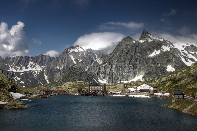
Great Saint Bernard Pass: Atmospheric Location in Grand High-Altitude Alpine Setting.
The Via Francigena
In the Middle Ages, this was an important route, used by merchants on the way to the commercial centers in the Po valley and the merchant towns beyond the Alps, and by pilgrims going to Rome and the Holy Land. This route was called the “Via Francigena”, meaning the linking route between the Mediterranean countries and the land of the Franks. The “Via Francigena”, starting from the Flanders, Champagne and the Franche-Comté, continued along the banks of the Geneva lake, past the dyke of Agaune, up to the Rhône valley and the valley of Entremont, to cross the Alps right at the Great Saint Bernard Pass (2,473 m). The route crosses the whole region, first along the Artanavaz stream, then into the main Aosta valley, running along the course of the Dora Baltea river. The orographic bounds of this region are so strong that the historical road network (from the Roman road of Gaul, the so-called Strada Romana delle Gallie, to the Medieval tracing, to the variations of the 18th and 19th century) has mainly been followed by State roads Nos. 26/27, which go along the Aosta Valley and enter the side valley of the Great Saint Bernard, converging onto Aosta itself (the regional capital). However, it is possible to go back and outline the main route of the “Via Francigena” by following the tracks linking the hospices, placed on strategical points such as mountain passes, and the remains of Roman and Medieval infrastructure and monuments; in particular, the parish churches and the oldest chapels. Now the track of the ancient “Via Francigena” is doubled by a long-distance walking route, connecting this part of the Alps to Rome (and beyond) through the whole of Italy.
The Route to the Great Saint Bernard Pass
Frequented since the Neolithic era, this is the pass which, at an altitude of 2,473 m above sea level, makes communication and trade possible between the two sides of the Alps and, in general, between Central/Northern Europe and the Mediterranean. The starting point for the ascent is the village of Saint-Rhémy-en-Bosses, the last inhabited settlement on the way up. In past times, the men of the village – the so-called marroniers – held the right to accompany travellers and provide the necessary for the trek. Leaving the village, the mountain track runs between the Great Saint Bernard stream and the national road (coinciding with the latter for a stretch); then, from the pasture lands of Les Toules, the route can be identified with the paved service road leading to the old oil pipeline. Beyond the locality of Prà Zentor, climbing upwards, bend after bend, and past a tombstone and a pillar that commemorate two travellers who lost their lives during the crossing, the route reaches Fonteinte (2,000 m): an ancient stopover for rest and refreshment (possibly a former Roman mansio) – run by the Hospice at the pass. Above this level, the forests dwindle, giving way to the typical high-altitude environment of bare grassland and, for a stretch, the mountain track is a mere trace, but then it becomes a good mule track again, dominated by a mountain called Tour des Fous, which legend holds was infested by the Saracens before the Hospice was built at the pass. The route then crosses the National road and, after a last well-conserved stretch of Roman road, hewn from the mountain rock, it reaches the so-called Plan de Jupiter, the Jupiter’s Plain, where, in Roman times, a temple was dedicated to Jupiter Pennino, and two mansiones (used as refuges) stood on the site of a prehistoric cult relating to the Celtic divinity Penn. The view from here reveals the glacial lake (see image above), which is crossed by the Italian-Swiss border, and the Hospice, built in the 11th century by the saint after whom the pass is named, which is now run by Augustinian Fathers.
The Great St Bernard Pass
The Great St Bernard Pass (Col du Grand St-Bernard, Colle del Gran San Bernardo, Grosser Sankt Bernhard) is the third highest road pass in Switzerland, at an elevation of 2,473 m (circa 8,100 ft). It connects Martigny in the canton of Valais with the Aosta valley region of Italy. It is the lowest pass lying on the ridge between the two highest mountains of the Alps, Mont Blanc and Monte Rosa. It is located on the main watershed that separates the basin of the Rhône from that of the Po.
The Great St. Bernard is one of the most ancient passes through the Western Alps, with evidence of use as far back as the Bronze Age and surviving traces of a Roman road. In 1800, Napoleon’s army used the pass to enter Italy (read below), an event depicted in two notable oil paintings. Having been bypassed by easier and more practical routes, particularly the Great St Bernard’s tunnel, a road tunnel which opened in 1964, its value today is mainly historical and recreational, being a highly panoramic and atmospheric spot; however, by road, it can only be reached June to September.
Straddling the highest point of the road, the Great St Bernard’s Hospice was founded in 1049. The hospice later became famous for its use of St Bernard dogs in rescue operations.
Geography
The pass runs northwest–southeast through the Valais Alps (formerly known as the Pennine Alps after the Roman name for the pass – poeninus mons or summus poeninus), at a maximum elevation of 2,473 m (circa 8,100 ft). The road running through the pass, highway E27 in both Italy and Switzerland, joins Martigny in the upper Rhône valley in the canton of Valais, Switzerland, to Aosta in the Aosta valley region of Italy. From Martigny Route 9 descends to Lausanne, while from Aosta the A5 motorway descends to Turin.
From the north, in Switzerland, the route to the pass follows the lower part of the river Drance above Martigny, then enters the wild and desolate Val d’Entremont (lit.: “valley between mountains”) through which the Drance d’Entremont flows. The Great St Bernard’s tunnel (and the main road) plunges through the mountain at a 1,915 m (6,283 ft) level, reducing, since the tunnel’s opening in 1964, the commercial relevance of the road over the pass.
On the south side, the route follows the steep slopes of the upper part of the torrent du Grand Saint-Bernard valley, then turns to the east and follows the stream in a bend to the south, where it enters the torrent Artanavaz valley near Saint-Rhémy-en-Bosses and turns to the east again, then veers smoothly to the southeast at La Clusaz (Gignod). Here the road enters the Buthier stream valley at the lower end of the Valpelline and turns south again, where finally the stream flows into the Dora Baltea valley near the Pont de Pierre in Aosta. The route here in the main Aosta valley becomes part of the A5 motorway connecting the Mont Blanc tunnel to the west to the upper Po valleys basin to the southeast.
A reduction of utility began after the construction of the Simplon tunnel, strictly speaking a railway tunnel, 100 km (62 mi) to the east in 1905. The much smaller historic road winding over the pass itself, which lies a few hundred metres from the Swiss border with Italy, is only open June to September.
The pass at its narrowest point runs between the peaks of Grande Chenalette at 2,889 m (9,478 ft) and Mont Mort at 2,867 m (9,406 ft). Slightly to the west is the Pointe de Drône at 2,949 m (9,675 ft), the highest peak. Between it and the pass is the Petite Chenalette, at 2,885 m (9,465 ft).
Weather
The snow at the pass in winter may be as much as 10 metres deep. The temperature may drop as low as - 30 °C. The lake at the pass is frozen for approximately 265 days per year.
Ecology
The pass is well above the tree line. All the wood required for construction and firewood must be hauled in from some distance. On the south-west side of the pass is a small tarn, the Great St Bernard Lake, which captures melt water and does not support fish, even though attempts have been made to stock it. In past years the tarn has not always thawed completely in summer.
Alpine flowers are abundant in the vicinity: Gentiana clusii, Ranunculus glacialis, Dryas octopetala, Myosotis alpinus, Saxifraga oppositifolia are only some names, among many hundreds more. Moss is prolific and the rocks are lichen-covered.
The Hospice and the Dogs
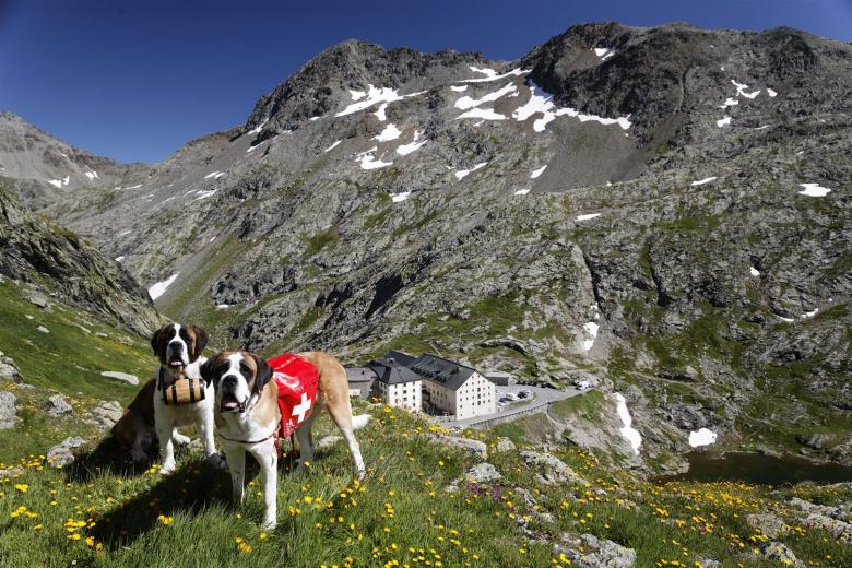
A hospice for travellers was founded in 1049 by Saint Bernard de Menton and came to be named after him in the 16th century, along with the pass. This was not the first hospice at the pass; buildings were probably there since the Roman mansio, but the region was not secure, and they were destroyed many times. The first concern of the founder of the current monastery was to clear the region of bandits and keep the pass safe for travellers, the role of rescuers developing naturally. The hospice later became famous for its use of St Bernard dogs (see image above; the hospice buildings are in the background) in rescue operations. Pope Pius XI confirmed Bernard as patron saint of the Alps in 1923.
The hospice straddles the highest point of the road, which is now in Switzerland. Today the modern road for through traffic has been routed around the outside of the monastery buildings to allow some integrity to the grounds. The old road may still be seen, above the paved road. The hospice occupies two buildings of 1560 and 1898. The Congregation of Canons of the Great Saint Bernard (the monks) also owns the Hôtel de l’Hospice du Grand-St-Bernard, a four-storey building made of grey stone (built in 1899) on the Italian side, which it leases to a private entrepreneur for the provision of hotel services.
The St Bernards dogs were bred large enough to traverse deep snow and to find lost persons by scent. The first evidence that the dogs were in use at the monastery is two paintings dating to 1690 by Salvator Rosa. It is often said that they carried small casks of liqueur (usually grappa, or brandy) around their necks (although, in fact, this is only legend), in the belief that the liqueur had medicinal properties.
Today the tunnel and modern technology have made rescue operations at the pass mainly unnecessary. The dogs were put up for sale in 2004 because of the high cost of maintenance and were promptly bought by two foundations created for the purpose: Fondation Barry du Grand Saint Bernard and Fondation Bernard et Caroline de Watteville. The Fondation Barry bought the kennels and the facilities in Martigny and continues to support and breed the dogs (three or four dozen). One condition of the sale is that they be brought to the monastery for the summer, where travellers are likely to see them romping around the slopes. The de Watteville Foundation keeps several dogs in kennels adjunct to its Musée. Both have agreed to work together, and others have joined the partnership.
The monastery currently houses a handful of monks on a permanent basis and serves as a spiritual centre for visitors, and people on retreat.
History
Celtic Period
The pass first appears in history as the route taken by the Celtic tribes of the Boii and Lingones in the invasion of Italy of 390 BC. The classical authors first mentioning the pass in that or other contexts lived in the 1st century BC under the early Roman Empire. They were calling the pass and the mountains Poeninus, Poenini or “Punic”, apparently in reference to Hannibal’s crossing. He did not cross there, however. On the presumption that the name was falsely altered by analogy, it can be reconstructed to *peninus, a Roman-Celtic word, considering that Celtic tribes owned the entire pass until defeated by the Romans. Livy says that the pass was not named after the Carthaginians but after a mountain god. For well over a century, scholars such as the Grimm brothers have made a connection with the Celtic root pen or ben, “head, summit, chief” on an analogy with the Zeus karaios of Hesychius.
Two tribes occupied the valleys on either side of the pass on a permanent basis: the Veragri on the Swiss side and the Salassi on the Italian side.
Roman Period
Julius Caesar sent an expedition under his best commander from Gaul, Servius Galba, in 57 BC to seize the pass, hoping to obtain a shorter route between Italy and Gaul than the contemporary coastal route. Galba was deceived by the Veragri into making camp near Martigny with the expectation of moving to the pass on the next day. At that time the Romans found the heights over the trail occupied by three hostile Gallic tribes. The Romans won a local victory by a daring foray from the camp, but Galba judged he could not take the pass and departed.
Augustus succeeded where his adoptive father failed, and the pass became Roman. Augustus placed a large castra stativa and founded a colony, Augusta Praetoria Salassorum, below the pass, which later became Aosta (contraction of Augusta); its ruins are a historic attraction today. By 43 AD., under the emperor Caludius, a good Roman road through the pass was completed, with a mansio at the top and a temple to Jupiter Poeninus, resulting in the name Mons Jovis in late antiquity, Monte Jove in the early Italian period and Mont Joux in the French period – a synonym for the pass. The site of the temple is known as the Plan de Jupiter, located on a knoll on the Italian side of the pass. A cross was placed there in 1816 bearing the inscription Deo optimo maximo, “to the best and greatest God”. The bronze statue of St Bernard on a pedestal above the road on the Italian side, across a small valley from the cross, was constructed in 1905 on the site of the Roman mansio.
The coins and votive tablets found at the site of the temple roughly date the upper limit of Roman control of the pass. The youngest date to the reign of Theodosius II (first half of the 5th century); these and other artifacts are stored in the monastery museum. Fragments of the marble temple, some with inscriptions, have been incorporated into many structures of the village of Bourg-Saint-Pierre on the Swiss side of the pass. The Roman milestone for mile XXIIII was also brought to the center of the settlement from the top of the pass.
Napoleonic Crossing
The pass had entered history with the Gallic invasion of 390 BC. The last Gallic invasion over it occurred in May 1800, under the direction of the 30-year-old First Consul of the French Republic, Napoleon Bonaparte. An Austrian army of 140,000 men had laid siege to French-occupied Genoa, Liguria, on the west coast of northern Italy. Napoleon traversed the pass with 40,000 men and ⅓ of their heavy artillery sending another 20,000 over three other passes as a diversion, intending to strike the Austrian rear. The panicked Austrians were unable to assemble fast enough to meet the French en masse but in a rather piecemeal way in June 1800, and so were defeated first at the battle of Montebello and then at the battle of Marengo.
Napoleon prepared for the march secretly by assembling men in small units below the pass, establishing supply dumps along the lower part of their route, and hiring artisans to set up shop along it as well. On May 15th an advance unit went over the pass to take Aosta, after which hospitals were set up at Martigny and Aosta. At Martigny the army assembled and received rations for three days. All the equipment – carriages, artillery, arms, and ammunition – was disassembled and divided into packs of 60-70 pounds for the men to carry. The cannons were to be dragged up over the snow in hollowed-out pine half-logs by mules, and then when the mules died or were exhausted, by 100 soldiers and hired men each. Napoleon offered liberal monetary rewards to soldiers and laborers who could perform difficult portages in a timely fashion.
Over several days at the end of May the army went over the pass single-file, 6000 men per day. Bands played martial music along the route, with drum rolls at especially difficult places to alert the men. At the top, the monks handed each man two glasses of wine and a slice of rye with cheese as they filed by (courtesy of the French army); accounts of the amounts expended vary. On the other side, the snow became so packed that the men slid down sitting; Napoleon was the last man over, sliding also. The good weather held for the entire crossing, which could easily have turned into a disaster, had it not.
On the way up, Napoleon had discussed affairs of the heart with his young guide and mule driver, Pierre-Nicholas Dorsaz, who did not know his identity. Offered a reward at the top, Dorsaz asked for the mule on which Napoleon was riding. He received the mule and a short note for the chief supply officer of the army. Versions of the story vary, but they all agree that when the young man had turned in the note and had drawn his ample pay for the work, he found that his companion was Napoleon and the latter had given him a house and farm so that he could marry his sweetheart.
In the Aosta valley Napoleon’s army slipped by an Austrian garrison at Bard fort, just out of cannon range. The commander related that he was astonished to watch an army of 40,000 men in full equipment go marching past, coming from the direction of the heights.
The Pass in Literature
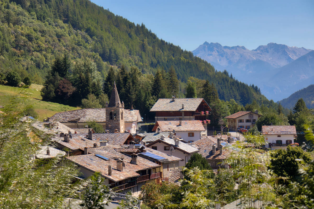
The Dorrit family crossed from France into Italy in Book Two: Riches of the novel Little Dorrit by Charles Dickens. They meet the newly wed Gowans and the gentlemanly murderer Rigaud, now called Blandois, at the inn after climbing up on mules. The novel was published in 1857 but set in the mid-1820s. Dickens describes the site of the pass, and the experience of staying overnight in the inn, having visited it formerly in person (above, an image of the atmospheric stone village of Saint-Rhémy-en-Bosses, at the beginning of the ascent towards the pass, on the Italian side, and sited along the long-distance route doubling the track of the ancient “Via Francigena”).
Return from Great Saint Bernard to Home
Return from Great Saint Bernard to Aosta Valley

New! Comments
Have your say about what you just read! Leave me a comment in the box below.