- Italy Tours Home
- Italy Ethos
- Tours 2023
- Blog
- Contact Us
- Dolomites
- Top 10 Dolomites
- Veneto
- Dolomites Geology
- Dolomiti Bellunesi
- Cortina
- Cadore
- Belluno
- Cansiglio
- Carso
- Carnia
- Sauris
- Friuli
- Trentino
- Ethnographic Museums
- Monte Baldo
- South Tyrol
- Alta Pusteria
- Dobbiaco
- Emilia-Romagna
- Aosta Valley
- Cinque Terre
- Portofino
- Northern Apennines
- Southern Apennines
- Italian Botanical Gardens
- Padua Botanical Garden
- Orchids of Italy
Belluno, Small Capital of the Dolomites, at the
Crossroads where Art and Nature Meet.
Belluno is the main centre of an extensive province that covers a large section (about two thirds) of the Dolomites region.
The town also presents much interest in itself, so the aim of this page is twofold: to give a geographical overview of the province as well as a brief introduction to what there is to see in town.
As for the first point, the whole territory of the province is articulated around the basin of the Piave – Veneto’s most important river – and some of its tributaries; in order, north to south: Ansiei, Boite, Maè, Cordevole and Cismon.
The first two rivers form the sub-region of Cadore. The Maé crosses the Zoldano sub-region, while the Cordevole is the axis of the Agordino sub-region. Lastly, the Cismon runs through the Feltrino area (its upper reaches belonging, in fact, to Trentino).
Belluno: an Atmospheric Medieval Centre with Interesting Monuments
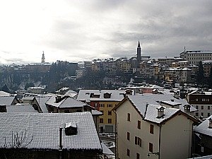
When it comes to the town of Belluno itself, it is situated at the confluence of the Ardo stream as it flows into the Piave, and its historic centre is built on a small plateau, on an elevated, strategic position between the two rivers.
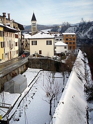
This open setting affords extensive views on the Piave valley (in this section called Val Belluna) and the surrounding hills and mountains (above, a view of Belluno town centre from the other side of the Ardo).
The centre is mostly 16th century in appearance, with many interesting architectures dating back to the time of the Venetian domination (1404 to 1797).
This is not the appropriate setting for a detailed explanation of what there is to see and visit in each monument, but still I would like to offer a broad orientation. I will therefore enucleate the main sights briefly, concentrating perhaps on some curiosities that are not usually dealt with elsewhere.
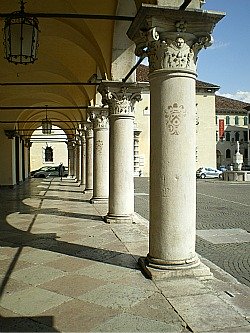
The most animated place in Belluno is its main square, Piazza dei Martiri: a big, triangular-shaped space known as ‘Listòn’, lined on one side by arcades under which are all the best shops and cafés in town.
But the most interesting sight is undoubtedly the monumental compound of the two adjacent squares Piazza Duomo and Piazza delle Erbe.
In the first one (pictured below), the most notable building is the Palazzo dei Rettori – a majestic architecture dating back to the early Renaissance period (1491).
At that time, this was the city’s most important building, as it used to be the seat of the government representative in Belluno at the time of the Venetian domination.
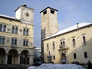
The other notable building is of course the Duomo itself – gothic in its basic layout (most evidently in the exterior), but with a harmonious interior in Renaissance style, dating to the 16th century.
Here, some important paintings of the Venetian school are to be admired (Andrea Schiavone, Cesare Vecellio, Jacopo Bassano, Palma il Giovane).
Particularly atmospheric is the secluded crypt – which is certainly the most peaceful part of the building, and one that most visitors miss, as it can be accessed only by an inconspicuous flight of stairs to the left of the main altar (bear in mind, though, that it is not always open). The crypt also displays a delicate Gothic triptych of uncertain attribution.
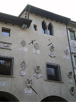
The adjacent Piazza delle Erbe – formerly the site of the Roman forum – with a pretty fountain in the centre, is more intimate in scale, and it is animated in the morning hours by a characteristic vegetable market. It is enclosed on one side by the Palazzo del Monte di Pietà (1501-31), with a façade embellished by stone coats of arms (see picture below).
On the other side of the square, notice the column on the corner: this is the former Loggia dei Ghibellini (1471), where the wrongdoers used to be punished by being hanged in a swinging cage that left its marks.
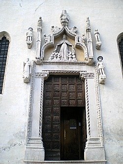
In terms of monumental buildings, the other highlight in Belluno is the church of Santo Stefano, which is actually my favourite.
Set apart in a pleasant, secluded square, the exterior of this building is in a plain, simple Gothic style, but the side entrance displays a fine sculpture representing a “Madonna of the Misericordia”, dated 1468 (pictured below).
The interior of this church is particularly atmospheric – again Gothic in its basic outline, and with a two-coloured alternation of dark red and white marble bands.
There are notable works of art, too: paintings by Cesare Vecellio (who belonged to the same family as the famous Titian), a wooden Crucifixion and two angels by renowned sculptor Andrea Brustolon (1662-1732), a cycle of finely restored frescoes attributed to Jacopo da Montagnana (15th century) and a side chapel covered with elaborate, somber wood carvings, containing also a dramatic statue of the “Madonna Addolorata” (1737).
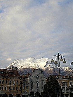
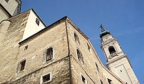
As said before, though, given its elevated position, the centre of Belluno is particularly evocative for its views over the Dolomites – especially so when looking to the north, where the Dolomiti Bellunesi act as a natural backdrop to the city’s squares and open spaces, framed by the Medieval outline of the Civic tower or the fine Baroque bell tower of the Duomo, erected in 1732-43 by the famous Piedmontese architect Filippo Juvarra (see below an image of the side of the Duomo).
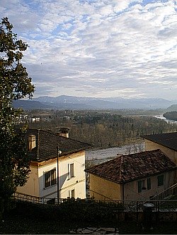
Looking south, the landscape is more open, and the gentle slopes of Nevegal-Col Visentìn dominate the scenery. The distant views on the Piave valley, fading in the hazy horizon towards Feltre, can be glimpsed from several locations too (see picture below), and can make one reminisce of many 18th century painters vistas.
That is the time when in and around Belluno flourished a small and little-known school of landscape artists (like Ippolito Caffi, for example), and some of their production can still be appreciated in the small but interesting Civic museum, together with the works of Sebastiano Ricci – perhaps Belluno's most famous painter of all times, but usually more associated with Venice.
In Belluno it is pleasant also to just walk around, and lose oneself in the tiny alleyways that radiate either side of Via Mezzaterra – the main axis of the Medieval centre, traced on the Roman decumanus, enlivened by colourful houses and the gurgling sound of the many fountains that bring right into town the water tumbling down from the Dolomites.
Particularly fascinating is the timeless atmosphere of Via Santa Maria dei Battuti, eventually leading to the charming riverside neigborhood of Borgo Piave – so called as in the old times this used to be the fluvial port, where the wood floating down the river was gathered and sorted before continuing its journey southwards (see images below).
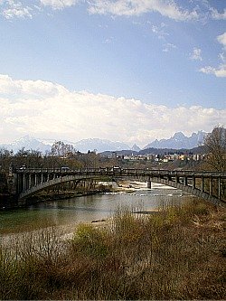
The peculiar position of Belluno town centre – elongated on what is similar to a peninsula suspended above two rivers (see above an image with the historic Ponte della Vittoria) – means that it was also relatively easy to pedestrianize it.
A few years ago the hisrtoric centre was freed almost completely from cars, thanks to a modern and ingenious scheme of combining parking with escalators. This makes its visit not only architecturally and historically compelling, but also – as an added bonus – traffic free.
As can already be appreciated, in addition to being an interesting destination in its own right, Belluno can also serve as a first orientation point and, in many ways, as a gateway to the Dolomites and to many other areas of natural beauty that lay in all directions all around town – especially to the north.
Getting Into Nature from Belluno.
The Nevegàl-Col Visentìn area
The natural places to visit most close at hand, and which can be enjoyed with the greatest ease from Belluno, are perhaps those in the Nevegàl-Col Visentìn area.
The people of Belluno have always had a particular fondness for this mountain, perhaps because it is, in many ways, their easiest ‘escape into Nature’; as a consequence, some parts of it have been degraded by clusters of second homes that do not look particularly attractive, but move further beyond and you will find sights and worthwhile things to do.
Along the way leading towards the Nevegàl from Belluno one passes the interesting little church of San Mamante, built on an ancient site of Pagan worship, which contains a cycle of old frescoes (unfortunately it is usually closed).
From there, one could in fact continue on foot towards the Nevegàl through pleasant paths in the woods. But past the ugly resort of Nevegàl itself, especially appealing, in my view, is a visit to the Botanic Garden of the Oriental Alps (“Giardino Botanico delle Alpi Orientali”), a real hidden jewel tucked away on the upper reaches of Monte Faverghera, half-way up the natural slope that – should you care to continue – would lead to the summit of Col Visentin (1,763 m): a rounded mountain that if, on one hand, is spoiled by the presence of radio and telephone masts, on the other will reward you with views that sweep the horizon at almost 360°.
Situated just above the deep cut of the Valle Lapisina, where the Lago di Santa Croce also lies (which can be admired from here with a dramatic perspective), the views range from the Cansiglio plateau to the majestic curtain of rocky mountains that close the Alpago region to the north.
Then, looking to the north-west, the jagged peaks of the Dolomiti Bellunesi and the Vette Feltrine come into sight, while turning to the south, the vast Venetian plains open up, with the magical, distant mirage – on exceptionally clear days – of Venice itself and its lagoon (the Campanile of San Marco is an unmistakable landmark).
This enchanting sight is more typical of limpid – and icy – winter days; but in fact, when northerly winds clear the air, it can happen in any season.
Closer by, a long sequence of hills continues to the west, and a relatively flat network of tracks and paths can be followed in that direction, leading to Rifugio Bristòt (1,616 m) and beyond.
In general, this area is quiet and little-frequented – perhaps a little less so in winter, as it is renowned for cross-country ski, and again on summer weekends, due to the closeness of town.
There are continuous views, alternated between the Venetian plain on one side and the open basin of the Val Belluna on the other. Should you wish, from there you can walk all the way to beautiful spots such as Valmorèl and Pian Coltura, renowned in spring for the blossoming of snowdrops and daffodils, which turn entire fields into undulated carpets of white and yellow.
A network of high and very little frequented roads also connects the municipalities of Trichiana and Limana to Belluno through small villages, while crossing areas of meadows and isolated farmsteads mostly devoid of human presence. A good option is to take the road from Sant’Antonio Tortal to Valmorel and then continue from there on a single track lane to Nevegal. This road will pass several interesting rock formations and it is sometimes carved in the rocks themselves (see picture below; although highly atmospheric, however, this road is best avoided in winter or with high snow).
A Strategic Position for Visiting the Dolomiti Bellunesi
If, on the other hand, you decide to head north of Belluno, here you will start ascending the slopes of much steeper mountains – the ante-chamber of the wilder Dolomiti Bellunesi.
Some sections are in fact already under the protection of a National Park, which has equipped two thematic trails there – namely, the solitary and romantic “Sentiero delle Chiesette Abbandonate” (the “Trail of the Forgotten Churches”) and the equally appealing “Via degli Ospizi” (the Way of the Hermitages).
The first trail is centered on the many chapels and little churches that were built on these little-inhabited slopes since time immemorial, sometimes in locations that were places of Pagan worship long before.
The saints to which the chapels are dedicated – San Liberale, San Gottardo, San Michele, San Martino and San Floriano – bear witness to that continuity of use, as often these were warrior saints, highlighting also a connection with the not-too-distant Germanic world.
Following on that note, the second trail is centered on the idea of a Pilgrims’ route, which in ancient times used to connect Germany and Northern Europe to Rome through the corridor of the Val Cordévole. For that reason, a number of monasteries and hospices sprung up along the way – the most notable of all certainly being the Certosa di Vedàna.
Documented since the 12th century, this religious compound was rebuilt in the 17th century as a charterhouse that is still today inhabited by an enclosed order of nuns, and for that reason it is unfortunately barred to the general public.
The building still remains an amazing sight, though, unmistakable with its pale-yellow coloured walls, and impressively located at the foothills of the Dolomiti Bellunesi just before entering the narrow, impressive gorges of the Val Cordévole (known in this section as Canale d’Agordo) to the east and the Valle del Mis to the west. Further on from here, paths would take you into wilder and relatively uncharted territory.
Another popular outing from Belluno is the ascent to Monte Schiara (2,565 m) and the Rifugio VII Alpini. Geographically as well as visually, Mt. Schiara is probably the closest mountain to town.
Roads lead up to Bolzano Bellunese or the Col di Roanza, from where one has to continue on foot on trails that soon enter open meadows, affording wider and wider views over the city and the Val Belluna beyond.
The only setback is that, being relatively close to town and because of the modest altitude (1,502 m), the area around Rifugio VII Alpini can easily become a crowded playground – especially so in busy summer weekends.
But keep walking past the mountain hut, and you will soon find yourself following the trails of the Alta Via (Alpine Highway) No. 1 – the so-called 'classica'.
This would take you close to the top of Schiara itself, and the curious geological quirck of the Gusela del Vescovà just beside it – in the shape of a needle – but it has to be reminded that, after a certain point, specialized equipment will be required in order to continue.
On a more gentle note, it is also worth remembering that the area around Monte Serva (2,132 m) – an outlying summit of the Schiara group – is a lot easier to reach, and has long been renowned as a plant-hunter's paradise for its notable flora.
Pretty much the Belluno counterpart of the more famous Vette Feltrine to the east, an excursion here at the height of summer can be highly rewarding – especially if Alpine flora is what you're after.
The Ardo Valley
The Ardo valley can certainly be considered among the most noteworthy features within the Dolomiti Bellunesi National Park. It is distinguished by a discreet charm, and the atmospheric – but perhaps a bit gloomy – appearance of its canyons (being so narrow, they don’t receive much sunlight – especially in winter).
This valley is also notable for its small rural settlements – remnants of an old time and mostly abandoned by now – and for the innumerable traces of activities linked to past and recent human activities (such as trails, mule-tracks, cultivated patches, old rural buildings, dry stone walls, terracing – and the ‘casere’, old traditional dairy pens).
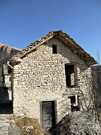
One of such hamlets, with characteristic stone buildings, is Case Bortot (pictured below), which is usually also the starting point for the excursion to the Bus del Busòn, described further down, which can either be visited as a single destination or within the context of a circular trail that also starts from here.
The Ardo forms a deeply cut valley originated by the confluence of a well-developed network of smaller rivulets and impluvia that criss-cross and drain the southern side of the Schiara group. To the north, it pushes deep into the mountains, while on the other side – often imprisoned into humid and dark canyons – it almost reaches the outskirts of the provincial capital of Belluno.
The valley – deeply embanked in various sections – cuts in fact through the whole stratigraphic succession of Dolomite rocks, from the most ancient layers (Main Dolomite and Soverzene Formation) to the more recent ones (Tertiary Flysch and Molasses formations), within the sub-montane sector of the park.
The frequent sections of canyons (with a narrow and constricted valley floor, confined by smooth and overhanging rock walls) testify to the relevant role played by the Ardo to shape the morphogenesis of the valley.
The diffused and noteworthy presence of glacial deposits – often embanked and affected by landslides and erosion phenomena – documents in all respects also the important role played by glacial molding, through the action of a crept-in side branch of the Piave glacier, exerted during the culminating phases of the last glaciation.
Along the valley it is possible to observe two different canyons that witness the deviations in the course of the Ardo: the Bus del Buson and the Pont de la Mortis.
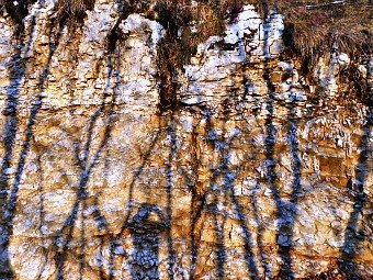
The ‘fossil’ canyon of Bus del Buson, deeply cut into the Biancone (a white flint limestone), is an extremely narrow canyon, probably incised by a sub-glacial stream during the final phases of the last glaciations (when the valley was still occupied by a glacial ‘tongue’); then, it was abandoned by the stream when the ice sheet drew back (see image below).

In the area of Pont de la Mortis, the stream draws an ample bend and runs in a narrow gorge, deeply cut into the marl limestone of the Scaglia Rossa (‘Red Scaglia’). This gorge – which is rendered even more atmospheric by the contrast between the red rocks and the crystal clear water – represents a relatively recent ‘gap’ that the stream was forced to open following a huge landslide (the accumulation of material is clearly visible just after the bridge to the left) which had submerged the old valley, forcing the water course to move further to the right (west).
It is a fossil gorge (technically speaking, an epigenetic gorge) – a gap that the Ardo was forced to open in relatively recent geologic times, which was then abandoned by the stream when the ice sheet drew back.
The Cordevole valley
The Cordevole valley represents a ‘canale’: a deep and narrow corridor, cut in rocks and connecting the Dolomites to the Pre-Alpine sector – that is, the Agordino to the Bellunese. It is a very ancient transversal valley that crosses the entire chain of the Dolomiti Bellunesi.
As it often happens with ancient valleys, it is a complex environmental system, to whose morphologic evolution have contributed several factors: valley glaciers, old water courses, degradation of the side slopes (landslides and erosion) and, locally, karstic corrosion too.
The glacial molding, mainly due to the action of an inserted branch of the ancient Cordevole glacier during the glaciations, is recognizable by the vaguely ‘U-shaped’ valley’s transversal profile (detectable by a relatively ample valley floor with steep, and often craggy, side slopes).
Particularly atmospheric is the section between La Stanga and Castei, which takes on the aspect of a deeply cut gorge incised in the sub-horizontal rock layers of Main Dolomite (karstic canyon).
The main valley is flanked by a system of deep and narrow side valleys and canyons, some of which are clearly structured along old important fault lines (Val di Piero, Val Vescovà, Val Pegolera).
With short digressions from the main road, it is possible to reach and explore very interesting and atmospheric micro-habitats, such as:
a) The Val di Piero waterfall – a high drop in a canyon environment;
b) the torrent conoid at Agre – an ample prairie created by a series of gravelly floods deposited by the Pegolera stream;
c) the epigenetic canyon at the beginning of the Val Pegolera and the evorsion potholes present at the bottom – ‘pots’ that have been excavated on the rocky layers of Main Dolomite by the gurgling waters and the detritus transported by old floods;
d) the Cordevole river bottom, presenting a rich variety of rocks and pebbles: white-colored (limestone, Dolomite); dark-colored (of volcanic origin: porphyry, andesite, volcanic sandstone); multicoloured (conglomerate, Gneiss) and silver-grey stones (Phyllites).
The anthropic (human) aspect is connected with detritus deposits derived from the excavation of galleries for hydro-electric purposes. There is also a fault line in the Main Dolomite rock, visible from the right flank of the Castei valley.
“La Pissa del Castei” is a singular waterfall that dried up during the digging work for the Castei road gallery; to remember it, there still is a cone-shaped deposit in travertine. Above Castei, there is also a Dolomite tower known as ‘La Panocia’.
Dino Buzzati and the Magic of the Dolomites
Going back to the cultural and historic side, there is yet another aspect of the area around Belluno that deserves a mention, as its serene, hilly countryside was often chosen, during the 16th and 17th centuries, by the local nobility to build their villas, in Venetian style.
Close to the city centre, and visible just north of the train station, is the Villa Vescovile al Belvedere, which is perhaps the most notable example of a local 18th century stately home, erected on a panoramic promontory between 1711-14 by architect Alessandro Tremignon, as a summer residence for bishop G. F. Bembo (unfortunately it is not open to visitors).
On the other side of the Piave, just out of town is Villa Buzzati, which belonged to the family of the renowned writer and journalist Dino Buzzati.
Dino Buzzati is a very well known name in 20th century Italian literature: often referred to as the “Italian Kafka” for its surreal prose, he also wrote a lot about the myths and stories of his native Dolomites.
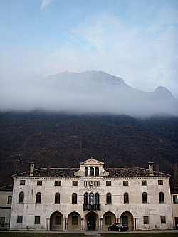
Today the villa has been turned into a smart B&B, and in summer its beautiful grounds sometimes host open air cultural events (pictured below, a 17th century villa in Safforze, just outside Belluno).
All in all, and as a closing note, it is evident that Belluno and its surroundings have really a lot to offer, both in terms of places of cultural interest and natural sights.
Return from Belluno to Italy-Tours-in-Nature
Copyright © 2019 Italy-Tours-in-Nature

New! Comments
Have your say about what you just read! Leave me a comment in the box below.