- Italy Tours Home
- Italy Ethos
- Tours 2023
- Blog
- Contact Us
- Dolomites
- Top 10 Dolomites
- Veneto
- Dolomites Geology
- Dolomiti Bellunesi
- Cortina
- Cadore
- Belluno
- Cansiglio
- Carso
- Carnia
- Sauris
- Friuli
- Trentino
- Ethnographic Museums
- Monte Baldo
- South Tyrol
- Alta Pusteria
- Dobbiaco
- Emilia-Romagna
- Aosta Valley
- Cinque Terre
- Portofino
- Northern Apennines
- Southern Apennines
- Italian Botanical Gardens
- Padua Botanical Garden
- Orchids of Italy
Aosta Valley: the Highest Peaks of the Alps in Italy’s “Small Tibet”.

Geography and General Description
The Aosta Valley (Valle d’Aosta in Italian; Vallée d’Aoste in French) is a mountainous autonomous region in northwestern Italy. It is bordered by France to the west, Switzerland to the north, and by Piedmont to the south and east. The regional capital is the town of Aosta.
Covering an area of 3,263 km2 (1,260 sq. mi) and with a population of about 128,000, it is the smallest, least populous, and least densely populated region of Italy. The province of Aosta having been dissolved in 1945, the Aosta Valley region was the first in Italy to abolish provincial subdivisions altogether. Provincial administrative functions are provided by the regional government. The region is divided into 74 comuni (communes in French), or municipalities.
Italian and French are the official languages, though the native population also speaks Valdôtain, a dialect of Franco-Provençal origin. Italian is spoken as a mother tongue by 77.29% of population, Valdôtain by 17.91%, and French by 1.25%. In 2009, reportedly 50.53% of the population could speak all three languages – so one could well say that the region is trilingual.
The Aosta Valley is an Alpine valley which with its tributary valleys includes the Italian slopes of Mont Blanc (Monte Bianco in Italian) and, to the north (bordering with France and Switzerland), Grand Combin (4,314 m), Cervino (Matterhorn in German; 4,478 m) and Monte Rosa (4,634 m); to the south, bordering with Piedmont, is Gran Paradiso (4,061 m). This was just to mention those mountains peaking above 4,000 metres of altritude, as there are many other important mountains, the highest peak being Mont Blanc (4,810 m or 15,780 ft; pictured above). These are the highest mountains in the whole Alpine chain, and this makes Val d’Aosta the region in Italy with the largest portion of high territory.
The structure of the region, also, is peculiar: the axis of the main Aosta valley sees a progression of tributary valleys (some of them very long) that run, comb-like, north and south of the main river, the Dora Baltea. Let us see them one by one, starting with those to the north of the river; in sequence (as encountered from the south), these are: Gressoney (Val di Gressoney), Ayas (Val d’Ayas), Valtournenche, Great Saint Bernard/Valpelline (Val du Grand Saint Bernard) valleys; to the south, instead, we have the Champorcher, Cogne (Val di Cogne), Valsavarenche, Rhêmes (Val di Rhêmes), Valgrisenche and Little Saint Bernard (Val du Petit Saint Bernard) valleys. At the head of the main Aosta valley, where the impressive ramparts of Mont Blanc close the valley like a massive wall of rock and ice, we have two more, shorter tributary valleys running either side of Courmayeur: the Val Ferret to the north, and the Val Vény to the south.
Climate
The valleys, usually above 1,600 m (5,200 ft), have a cold continenatal climate (DFC). In this climate, the snow season is very long, up to 8 or 9 months at the highest points. During the summer, mists occur almost every day on the peaks; these areas are amongst the wettest in the western Alps. Temperatures are low, between −7 °C (19 °F) and −3 °C (27 °F) in January, and in July they can range between + 5° (41 °F) and 20 °C (68 °F). In this area is the village of Rhêmes-Notre-Dame (Val di Rhêmes), which may be one the coldest in the Western Alps, where the winter average temperature is around −7 °C (19 °F).
In the main valley floor, however, the climate is very different; it is still continental but dry, with extreme variations: winter can be cold with hard frosts, but with a predominance of sunny and dry conditions, and only very occasional snow; in the summer, instead, temperatures can soar high, and Aosta itself can be very hot indeed (up to 35 °C/95 °F). Summers are also rather dry, but a lot more humid and hotter, with rare thunderstorms (Aosta has a yearly average rainfall of only about 500 mm). Annual rainfall totals increase rapidly towards the head of the valleys (2,368 mm/year at the Great Saint Bernard pass).
These areas, between 2,000 and 3,500 m (6,600 and 11,500 ft), usually have a typically tundra climate (ET), where every month has an average temperature below 10 °C (50 °F). This climate may vary, from a kind of more severe cold oceanic climate, with a low summer average but mild winters, sometimes above −3 °C (27 °F), especially near lakes, to a more severe cold continental climate, with a very low winter average. Temperature averages at Plateau Rosa on Monte Rosa, for example (3,400 m/11,200 ft. high), are −11.6 °C (11.1 °F) in January and +1.4 °C (34.5 °F) in July. It is the coldest place with verifiable climate in Italy.
In the past, above 3,500 m (11,500 ft), all months had an average temperature below freezing, with a perpetual frost climate (PFC). In recent years, however, there was a rise in temperatures.
History
The first inhabitants of the Aosta Valley were the Celts and Ligures (Liguri), whose language heritage remains in some local place names. Rome conquered the region from the local population of the Salassi around 25 BC and founded Augusta Prætoria Salassorum (modern-day Aosta), to secure the strategic mountain passes, and they went on to build bridges and roads through the mountains. Thus, the name Valle d’Aosta literally means “Valley of Augustus”. This is also strongly connected with the presence of the Romans at the Great Saint Bernard pass (pictured above), where a famous place of worship was erected, and dedicated to Jupiter.
In 1031–1032, Humbert I of Savoy, the founder of the House of Savoy, received the title Count of Aosta from Emperor Conrad II of the Franconian line, and built himself a commanding fortification at Bard (Forte di Bard). Saint Anselm of Canterbury was in fact born in Aosta in 1033 or 1034. The region was then divided among strongly fortified castles, and in 1191, Thomas I of Savoy found it necessary to grant the communes a Charte des franchises (“Charter of Liberties”), which preserved autonomy — rights that were fiercely defended until 1770, when they were revoked in order to tie Aosta more closely to Piedmont, but which were again demanded during post-Napoleonic times. In the mid-13th century, Emperor Frederick II made the County of Aosta a duchy (with the Duke of Aosta), and the coat of arms was charged with a rampant lion carried in the Savoy arms, until the reunification of Italy in 1870.
The region remained part of Savoy lands, with the exception of French occupations from 1539 to 1563, later in 1691, then between 1704 and 1706. It was also ruled by the first French Empire between 1800 and 1814. During French rule, it was part of the Aoste arrondissement, in the Doire département. As part of the Kingdom of Sardinia, it eventually joined the newly founded Kingdom of Italy in 1861.
French forces briefly controlled the area at the end of World War II, but withdrew under British and American pressure. The region gained a special autonomous status after the end of World War II; the province of Aosta ceased to exist in 1945.
Government and politics
For more than 20 years the valley has been dominated by autonomist regional parties (Union Valdôtaine, or Valdostan Union).
The population density of the Aosta Valley is by far the lowest in Italian regions. In 2008, 38.9 inhabitants per km2 were registered in the region, whereas the average national figure was 198.8, though the region has extensive uninhabitable areas of mountain and glacier, with a substantial part of the population living in the central valley. Migration from tributary valleys has now been contrasted with the help of generous regional support for agriculture and tourist development.
Negative natural population growth since 1976 has been more than offset by immigration. The region has one of Italy’s lowest birth rates, with a rising average age. This, too, is partly compensated by immigration, since most immigrants arriving in the region are younger people working in the tourist industry. Between 1991 and 2001, the population of Aosta Valley grew by 3.1%, which is the highest growth among the Italian regions. With a negative natural population growth, this is due exclusively to positive net migration. Between 2001 and 2011, the population of Aosta Valley grew by a further 7.07%. As of 2006, the Italian National Institute of Statistics (ISTAT) estimated that 4,976 foreign-born immigrants live in the Aosta Valley, equal to 4.0% of the total regional population.
Culture: Languages
The Valdôtain population and their language dialects have been the subject of some sociological research.
The Aosta Valley was the first government authority to adopt Modern French as the official language in 1536, three years before France itself. In modern times, Italian and French are the region’s official languages and are used for the regional government’s acts and laws, though Italian is much more widely spoken in everyday life, and French is mostly spoken in cultural life. Education is conducted evenly in French and Italian, so that anyone who has gone to school in the Aosta Valley can speak French to at least a medium-high level.
The regional language, known as patoué valdotèn or simply patoué (patois valdostano in Italian, patois valdôtain in French), is a dialectal variety of Franco-Provençal. It is spoken as a native and second language by 68,000 residents, or about 58% of the population according to a sociolinguistic survey carried out by the Fondation Émile Chanoux in 2001.
The survey found out that the Italian language was spoken as mother tongue by 77.29% of respondents, Franco-Provençal by 17.91%, while French only by 1.25%. The residents of the villages of Gressoney-Saint-Jean, Gressoney-la-Trinité and Issime, in the Lys Valley, also speak two dialects of Walser German, known as Titsch and Töitschu, respectively. According to the survey, Walser German was spoken as mother tongue by 207 people, or 17.78% of the population, in these three villages. Nevertheless, it was known to 56.38% of the population.
Monuments: Castles
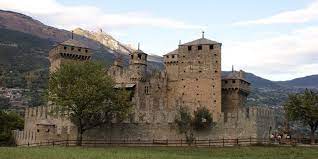
There are numerous medieval castles and fortified houses in the Aosta Valley, including Châtel-Argent, Sainte-Pierre, Fénis (pictured above), Issogne, Ussel, Sarre, Cly, Verrès, and Châtelard. Savoy castle in Gressoney-Saint-Jean was conceived in the 19th century and completed in 1904; since 1990, it has also been home to the Savoy Castle Alpine Botanical Garden.
The Astronomical Observatory of the Aosta Valley is in the locality of in Saint-Barthélemy, within the municipality of Nus.
The Via Francigena
In the Middle Ages, this was an important route, used by merchants on the way to the commercial centers in the Po valley and the merchant towns beyond the Alps, and also by pilgrims going to Rome and the Holy Land. This route was called the “Via Francigena”, meaning the linking route between Mediterranean countries and the land of the Franks. The “Via Francigena”, starting from the Flanders, Champagne and the Franche-Comté, continued on the banks of the Geneva lake, past the dyke of Agaune, up the Rhône valley and the valley of Entremont, to cross the Alps right at the Great Saint Bernard Pass (2,473 m; see below). The route crosses the whole region, first along the Artanavaz stream, then into the main valley, along the course of the Dora Baltea river. The orographic bounds of this region are so strong that the historical road network (from the Roman road of Gaul to the Medieval tracing, to the variations of the 18th and 19th century) has mainly been followed by State roads Nos. 26/27, which go all along the Aosta Valley and up towards the pass. However, it is possible to go back and outline the main route of the “Via Francigena” by following the tracks which connected the hospices, placed on strategical points such as mountain passes, and the remains of Roman and Medieval infrastructure and monuments; in particular, the parish churches and the oldest chapels.
The Route to the Great Saint Bernard Pass
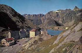
Frequented since the Neolithic era, this is the pass which, at an altitude of 2,473 m above sea level, makes communication and trade possible between the two sides of the Alps and, in general, between Central/Northern Europe and the Mediterranean. The starting point for the ascent is the village of Saint-Rhémy-en-Bosses, the last inhabited settlement on the way up. In past times, the men of the village – the so-called marroniers – held the right to accompany travellers and provide the necessary for the trek. Leaving the village, the mountain track runs between the Great Saint Bernard stream and the national road (coinciding with the latter for a stretch); then, from the pasture lands of Les Toules, the route can be identified with the paved service road leading to the old oil pipeline. Beyond the locality of Prà Zentor, climbing upwards, bend after bend, past a tombstone and a pillar that commemorate two travellers who lost their lives during the crossing, the route reaches Fonteinte (2,000 m): an ancient stopover for rest and refreshment (possibly a former Roman mansio) – run by the Hospice at the pass. Above this level, the forests dwindle, giving way to the typical high-altitude environment of bare grassland and, for a stretch, the mountain track is a mere trace, but then it becomes a good mule track again, dominated by a mountain called Tour des Fous, which legend holds was infested by the Saracens before the Hospice was built at the pass. The route then crosses the National road once again and, after a last well-conserved stretch of Roman road, hewn from the mountain rock, it reaches the Plan de Jupiter, the so-called “Jupiter’s Plains”, where, in Roman times, a temple was dedicated to Jupiter Pennino, and two mansiones (used as refuges) stood on the site of a prehistoric cult relating to the Celtic divinity Penn. The view from here reveals the glacial lake, which is crossed by the Italian-Swiss border, and the Hospice, built in the 11th century by the saint after whom the pass is named, which is now run by Augustinian Fathers.
Cuisine
The cuisine of Aosta Valley is characterized by simplicity and revolves around “robust” ingredients such as potatoes, polenta, cheese, meat and rye bread. Many of the dishes involve Fontina, a cheese with a protected status, made from cow’s milk that originates from the valley. It is found in dishes such as the soup à la vâpeuleunèntse (Valpelline Soup). Other cheeses made in the region are the Tomme de Gressoney (Toma di Gressoney) and Seras. Fromadzto (Valdôtain for cheese) has been produced locally since the 15th century and also has PDO status.
Regional specialities, besides Fontina, are Motzetta (dried chamois meat), Lard d’Arnad (a cured and brined fatback product with PDO designation), Jambon de Bosses (a kind of ham, likewise with PDO designation), and a dark bread made with rye and honey.
Notable dishes include Carbonnade, similar to the Belgian dish of the same name, consisting of salt-cured beef cooked with onions and red wine served with polenta; breaded veal cutlets, called costolette; teuteuns (salt-cured cow’s udder that is cooked and sliced); and steak à la valdôtaine: a steak with croûtons, ham and melted cheese.
Wine growing
Notable wines include two white wines from Morgex (Blanc de Morgex et de La Salle and Chaudelune), a red wine blend from Arvier (Enfer d’Arvier) and one from Gamay. All wines produced in the region befall under the denomination of Vallée d’Aoste DOC.
Return from Aosta Valley to Home

New! Comments
Have your say about what you just read! Leave me a comment in the box below.