- Italy Tours Home
- Italy Ethos
- Tours 2023
- Blog
- Contact Us
- Dolomites
- Top 10 Dolomites
- Veneto
- Dolomites Geology
- Dolomiti Bellunesi
- Cortina
- Cadore
- Belluno
- Cansiglio
- Carso
- Carnia
- Sauris
- Friuli
- Trentino
- Ethnographic Museums
- Monte Baldo
- South Tyrol
- Alta Pusteria
- Dobbiaco
- Emilia-Romagna
- Aosta Valley
- Cinque Terre
- Portofino
- Northern Apennines
- Southern Apennines
- Italian Botanical Gardens
- Padua Botanical Garden
- Orchids of Italy
Dobbiaco: Gateway to the Dolomites, Set Among Pastures and Deep Green Forests.
“Dobbiaco is Extraordinary: it Tempers your Body
and Soul”.
These words on Dobbiaco – Toblach in German – were spoken by Gustav Mahler, probably the town’s most famous visitor ever.
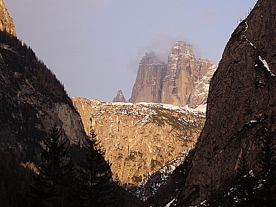
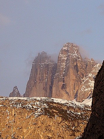
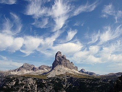
It is part of the three municipalities in the Alta Val Pusteria (Hochpustertal in German – together with neighbouring Sesto/Sexten and San Candido/Innichen – to have become known as one of the “Comuni delle Tre Cime” (Drei Zinnen in German; see picture above): the three communities – on the South Tyrol side – lying at the foot of these celebrated peaks that have become the symbol of the Dolomites.
For its peculiar location, Dobbiaco/Toblach is considered one of the key gateways to the Dolomites, situated at an altitude – 1,256 meters above sea level – that makes it ideally suited for both summer and winter activities.
The town is spread over a high, verdant plateau: a location that – despite being surrounded by tall mountains – is very open and abundantly sunny, especially during the summer months.
To the south, this plateau is protected by the rocky Dolomite crags of Cima Nove and Monte Serla, while on the northern side are the margins of the Western Tauern (Cornetto di Confine, Corno di Fana) – a mountain range which has most of its development in nearby Austria.
In many ways, Dobbiaco lays in a strategic position, being at a crossroads between three main communication arteries that connect it to Venice and the Dolomites’ heartland to the south; Bolzano/Bozen – and from there on to Tyrol and Bayern – to the west, and Osttirol (Austria) to the east. Only to the north is its territory ‘blocked’ by the main watershed ridge.
Interestingly enough, Dobbiaco’s municipality is itself split into two parts – this divide being not only between two villages, but rather between two hugely important water systems.
The river Drau (Drava in Italian) has its source just to the east of town (unbeknown to many, this long European river begins its life in Italy), and has the peculiarity of running all the way to the Danube.
Perhaps it is worth pointing out, then, that this part of Dobbiaco’s territory is, strictly speaking, outside of the Mediterranean zone, and draining – albeit for a small section – into the Black sea basin!
The other important river is the Rienza (Rienz in German), which has its source at the foothill of the Tre Cime and, after having formed the Lago di Dobbiaco/Toblachersee, it crosses the Dobbiaco plateau, then turns westwards to follow the whole length of the Italian section of Val Pusteria/Pustertal.
It eventually flows into the Isarco/Eisack just to the north of Bressanone/Brixen – this river eventually draining (through the Adige) into the Adriatic Sea, and thus belonging to the Mediterranean zone.
The town itself is also divided into two parts: Dobbiaco Vecchia/Alt-Toblach is the historical part, and is located at a slightly higher altitude in a more secluded location at the entrance of the Valle di San Silvestro/Wahlen.
Dobbiaco Nuova/Neu-Toblach, on the contrary, was newly created at the onset of the 20th century, following the arrival of the railway and a general betterment of the transportation system.
It is modern and less appealing, comprised mainly of a mixture of hotels, shops and other sports facilities. The Val Pusteria/Pustertal National Route divides the two parts quite neatly.
From the point of view of geology, Dobbiaco is situated on the boundary between the Central-eastern Alps and the South-eastern Alps.
Some parts of its territory are included within two Regional Parks,“Dolomiti di Sesto/Sextnerdolomiten” and “Fanes–Sennes–Braies/Prags”, which are both important nature reserves, belonging to the seven Natural Parks of South Tyrol.
The Origins of Dobbiaco/Toblach
In fact, the very name of the place bears probably a reference to its geographical location, as Duplagum – so the settlement is first mentioned in 827 – means “two waters”, which seems to be referring to either the two lakes in the vicinity (Landro and Dobbiaco) or – most likely – to the springs of the two rivers Rienza and Drava, mentioned above.
In Pre-historic times, first evidence of the presence of a settlement here dates to the late Iron Age, and the first inhabitants were probably Illyrians (from an archaeological site that was dug to the Northwest of the actual town).
In the 4th century BC the area was invaded by Celtic tribes, who progressively mingled with the previous inhabitants, and went on to form the Kingdom of the Noricum, which in 15BC subjected itself to the Romans. To the same time dates the foundation of nearby San Candido/Innichen – the main centre of the upper valley, then known as Littamum.
In the 1st century AD a road along the Val Pusteria/Pustertal was traced: the exact route has not yet been identified with certainty, but a milestone was found dated 247, during the reign of Philip II the Emperor.
At that time, the newly arrived Latin language superimposed itself on the Celtic and Illyrian idioms, thus creating a new Roman tongue – Ladin – still spoken today in many valleys of the Dolomites, although not here anymore.
With the fall of the Western Roman Empire, Dobbiaco fell under the dominion of Germanic people (the Ostrogoths and Bavarians). Despite that, for a long time the pressure of Slav populations over the region was strong, and it is ascertained that in 609 the Vends arrived through the Drau valley, conquering the area – to which followed the victory of the Bavarians over the Slavs.
The result of these different dominations left its mark on the territory – especially in place names – bearing evidence to the fact that this area had always been at an important crossroads for its strategic location.
The Bavarians were responsible for the diffusion of Christianity in the Pusteria/Pustertal, especially through the operations of Duke Tassilone III, who in 769 founded a Benedictine Abbey in San Candido/Innichen.
As a matter of fact, it is likely that Dobbiaco was founded as a result, together with other settlements in the upper valley. The local site of worship was dedicated to St. John the Baptist.
The Bavarian Duchy expanded over the years beyond the Sella di Dobbiaco/Toblachersattel into the territory of the Francs, which in 773 – under the rule of Charlemagne – conquered the reign of the Lombards.
Around year 1000, the Diocese of the Princes-Bishops started taking shape – and that is the time when the Pusteria/Pustertal was annexed to the territories belonging to the Prince-Bishop of Bressanone/Brixen.
Lay powers were handed over to aristocratic families, and the area of Dobbiaco was donated by the Prince-Bishops as a fiefdom to the Counts of Gorizia and Tyrol in 1271.
In 1363, the county was again handed over – this time to the Hapsburgs, then to the House of Bayern, and eventually – around 1500 – it came back to the Counts of Tyrol; from then on – and until 1919 – the history of Tyrol is strictly connected with that of Austria.
In those same years, relationships started to get strained with the neighbours to the south – the Republic of Venice. Those were also the times of the glory of Maximilian, Emperor of Austria.
The fact that Venice refused the passage of Maximilian’s troops across its territory was the cause of a war that led to two attacks to Botestagno castle – the Venetians’ outpost near Cortina – in 1508 and 1511; eventually, the Imperial troops won, conquering the castle – and the Ampezzo basin fell under Austrian rule.
In 1792 Tyrol fell again briefly under Bavarian domination for a brief spell, after which the area surrounding Dobbiaco was divided into three sections: Italian, Illyrian and Bavarian; finally, after the Congress of Vienna (1815), the entire Veneto became Austrian for a time.
The Origins of Tourism
From the second half of the 19th century onwards, tourist development started in Dobbiaco, with the consequent construction of new homes and infrastructures, and also the tracing of a railway line connecting Vienna with South Tyrol.
Most importantly, a Grand Hotel was erected – now turned into a cultural and congress centre. Several organizations of common utility were founded too, and the town became also known as a spa resort.
Mountain hiking and climbing became increasingly more popular, and that is the time when several peaks of the surrounding Dolomites were conquered.
In 1905, with the goal of further expanding the blooming tourist industry, a railway link was opened between Dobbiaco and Cortina – the so-called “Ferrovia delle Dolomiti”; then, everything came to a halt with the explosion of World War I, which saw some of its most bitter fights in the area.
During the war, this section of Val Pusteria/Pustertal became an operational zone, as it was very close to the boundary between Italy and Austria – which caused the town to be severely damaged by bomb raids.
After the Italian defeat at Caporetto (1917), though, the frontline moved away; in 1919, the Treaty of Saint-Germain eventually fixed the border in its present location, thus including Dobbiaco (together with Sesto/Sexten and San Candido/Innichen) under Italian soil.
It was only at the end of the hostilities – after 1919 – that the railways became operational again for civilian use, but the Cortina-Dobbiaco line reopened only in 1921.
After a brief peaceful spell, during the Fascist regime the area started to suffer again (as indeed the whole of South Tyrol) for the relentless campaign – pursued by the Fascists – of trying to erase the German background and culture, which have always been predominant in this region. Some restrictions – such as the banning of German names, prohibitions in the use of language, and closure of the schools – were particularly harsh.
Despite the violent Fascist cultural repression, during WW2 the area was largely unaffected by fights, even though – being so close to the border – Dobbiaco and its surroundings were largely used as a base for barracks and other military outposts.
After WW2, the signature of the First Charter of Autonomy for the region of South Tyrol – in 1948 – meant the opening of a whole new chapter.
Linguistic minorities were now formally recognized and protected; the use of German was fully reinstated by law, and – where applicable – of Ladin also (all signs in the region have been bilingual ever since – or even trilingual, where Ladin is spoken, but this is not the case in Dobbiaco).
Economy and tourism flourished again – in fact, ever more so than before – from the 1950s onwards; the “Cortina effect” (following the Winter Olympics of 1956) was also felt here.
Sadly, though, the faithful “Ferrovia delle Dolomiti” between Cortina and Dobbiaco closed in 1964, never to reopen again.
Then, after a period of neglect, the route of the former railway was reinstated, and it is now massively used as a pedestrian and cycle path over the summer, while it turns into a popular cross-country ski route during wintertime.
Religious Architecture in Dobbiaco
The Parish church of St. John the Baptist is the main religious building in Dobbiaco. It is constructed over the remains – of which nothing is left to see – of an original Benedictine building erected here in the 9th century.
The current church was built in 1764-1774, and is considered nowadays the most notable Baroque architecture in the upper Pustertal (“Alta Val Pusteria/Hochpustertal”).
This is because, as a whole, it managed to retain a certain purity of lines and its original proportions, while the interior is not burdened by later additions (as it happened with so many other churches in the valley).
The frescoes on the ceiling – depicting the story of St. John the Baptist, to whom the church is dedicated – are due to the Austrian painter Franz Anton Ziller, while Johann Perger is the author of many of the sculptures.
The dedication of this church to St. John the Baptist owes to the devotion of the Benedictine order for this saint.
The “Via Crucis” (Kalvarienberg) – starting outside the actual parish church by the Chapel of the Counts of Gorizia and Tyrol – is comprised of five chapels attributed to the famous Renaissance painter and artist Michael Parth.
They were erected in 1519, and the fifth and major chapel – with three rounded arches on pillars – is known as “Croce di Pietra” (Stone Cross).
The final building is the round Chapel of Lerschach, dedicated to Saint Joseph and erected originally on a Roman sediment.
The whole route of the “Via Crucis” was wanted by the Emperor of Austria, Maximilian, and was consecrated in 1568. As a note of curiosity, this Passion is exactly as long as the one in Jerusalem; it is the most ancient Passion route in South Tyrol, and the second most ancient in Mitteleuropa.
Other notable religious buildings in the Dobbiaco area include the sanctuary at Santa Maria/Aufkirchen, dedicated to Saint Mary.
Erected in 1262, it soon became the destination of an important pilgrimage, and was therefore reconstructed in 1470 in Gothic style, then again in 1730 and finally in 1877.
The imposing bell tower is frescoed with a gigantic image of Saint Bartholomew, probably realized – alongside with other frescoes – by Simone da Tesido at the beginning of the 1500s.
More traces of 15th century frescoes were discovered in the interior during the 1983 restoration works, thus attesting to the importance of this building for the local population since ancient times.
The small church of San Nicolò is in the hamlet of Valle San Silvestro/Wahlen, and its oldest parts are Gothic.
This religious building also displays a frescoed image of Saint Bartholomew, which dates to the 17th century. At that time, it was transformed into the Baroque style, but later alterations (made in 1865) reinstated the original Gothic structure – so that today the church looks almost entirely Neo-Gothic.
At an altitude of 1420 metres, on a wooded hill above the hamlet of Santa Maria/Aufkirchen (mentioned above) – and on a site that most likely was inhabited since Pre-historic times – the ancient church of San Pietro in Monte (Saint-Peter-by-the-Mount) can be reached through a path in the woods.
It lies at the end of a pleasant twenty minutes’ walk along a so-called “meditation path”, accompanied by the monoliths and sculptures of local artist Jakob Oberhollenzer, who was inspired by the biblical story of Saint Peter.
This atmospheric church had been abandoned for a long time, and has been painstakingly rebuilt, only to be reopened in 1996.
The ancient – and sacred – location is evident when one considers that on the day of winter solstice the rays of the sun that penetrate inside the chapel form a perfect square on the altar (if it is sunny!).
Other small religious buildings are situated along the old road that used to connect the main centres of the valley through an elevated route – such as the chapel by the Maso Taschler in Frondeigen (Franadega), or the Sanctuary of San Silvestro in Alpe.
This is found at an altitude of 1,912 metres along the old route to Monguelfo/Welsberg, and it is widely frequented during the summer months for its scenic location.
Civil Architecture in Dobbiaco
So much for the religious architecture. But in terms of civil buildings, there are important works too: the Grand Hotel was erected in 1877, and besides being the first hotel to be built in Dobbiaco, it was also one of the most important in the whole valley.
It was considered one of the foremost luxury hotels of its time, and for that reason – at the height of its fortunes – it hosted many notable figures and characters.
During WW1 the Grand Hotel suffered so much damage that it was never repaired, and at the end of the conflict it was abandoned. The impressive building then passed from hand to hand and became derelict, and it was only in 1991 – when it was finally purchased by the Autonomous Province of Bolzano – that, at last, restoration work took place.
The original structures were maintained but the destination was changed, as the impressive complex – despite being still called “Grand Hotel” – was turned into a multi-function culture centre, comprising educational facilities, a youth hostel, social housing, a holiday resort, a school of music and the visitor’s centre for the Dolomiti di Sesto/Sextnerdolomiten Natural Park.
Most importantly, it now contains the “Auditorium Gustav Mahler”: an astonishing concert hall – opened in 1999 – with optimum acoustics, where most of the initiatives for the yearly “Mahler Weeks Festival” take place.
Even though this Festival is the peak event of the year, the concert hall is also used throughout the rest of the year for concerts, conferences and other activities, making it the most important cultural hub not just for Dobbiaco but for the whole upper valley of Alta Val Pusteria/Hochpustertal.
In Dobbiaco there are several public fountains, both in the village and in the surrounding hamlets. Some are rustic and of an artisanal make, using wood as their main material, while the two in the centre of town are of historical relevance.
The project “Treasures of Water” – launched in 2001 – contemplates a trail connecting seven points of interest in and around Dobbiaco, centred around the theme of water and comprising fountains, springs, rivers, lakes, the district heating plant (see below) and kilns.
In terms of other notable civil architectures, one should certainly include Herbstenburg castle – an imposing defensive structure with castellated walls.
The castle, which was originally built as a tower, was expanded at the time of Maximilian of Austria, and actually used by the Emperor himself as a base when waging war on the Venetians.
Over the years, the tower was surrounded by fortifications, and a subterranean tunnel leading to the so-called “Torre Rossa” (“Roter Turm”; Red Tower) was also dug.
This latter building – erected in 1430 for defensive purposes – takes its name from the colour of the external walls. Several legends and myths – and some disquieting discoveries – shroud both castle and tower in mystery.
The Town Hall was erected in 1550 by the Counts Kunigl of Casteldarne/Eherenburg, who administered justice and tax collection until 1826. It is an elegant building with a square floor plan, which was used by the counts during the whole period of their jurisdiction.
Mahler and Dobbiaco
From Dobbiaco Nuova, it is possible to reach – via an easy route – the locality of Carbonin Vecchia/Altschluderbach (not to be confused with Carbonin/Schluderbach), where the Maso Trenker (Trenkerhof) is situated.
This is where the composer Gustav Mahler spent the summers from 1908 to 1910: it is here that he composed the Ninth and Tenth Symphonies (the latter one left unfinished), and the famous Song of the Earth (“Das Lied von der Erde”), the execution of which his author sadly never managed to listen.
Given Mahler's deep connections with Dobbiaco, entering the room where the famous composer stayed with his wife Alma is today a very touching experience.
From the Maso Trenker it is possible to reach a fauna reserve, in the middle of which is the so-called “Composition House” – a small wooden cabin where Mahler retired himself in silence in order to compose his music.
Since 1981, in memory of Gustav Mahler – whose name is inextricably linked with Dobbiaco – the “Settimane Mahleriane” (“Mahler Weeks”) are held, with an oustandingly rich program of conferences and concerts.
The main venue for this initiative is the “Grand Hotel” culture centre – with the impressive concert hall dedicated to the composer himself – but in fact the events are spread over the whole territory of the Alta Val Pusteria/Hochpustertal, taking place also in Villabassa/Niederdorf, Monguelfo/Welsberg, San Candido/Innichen, Sesto/Sexten and Sillian in Osttirol.
A short distance from Maso Trenker – along CAI trail marked No. 27 – are the hydro-mineral springs of Bagni di Maia/Bad Maistatt, cited for the first time in 1273 and appreciated even by the Emperor Maximilian, who sojourned here in 1511 to regain his health.
Today the establishment is closed, but a small chapel remains available for walkers to rest, and a spa water spring can also still be used.
Other Hamlets and Locations Around Dobbiaco
Dobbiaco has three main hamlets (frazioni): Carbonin/Schluderbach,Santa Maria/Aufkirchen and Valle San Silvestro/Wahlen.
Carbonin/Schluderbach is, in fact, little more than a cluster of holiday homes and hotels in the vicinity of the Lago di Landro/Durrensee – a beauty spot at the head of the valley bearing the same name (below, see an image of the Sorapiss, as pictured from the Val di Landro/Hölensteintal).
Santa Maria/Aufkirchen, on the contrary, is clustered around the most important sanctuary in the whole Pusteria/Pustertal. Etymologically, the German name of the locality literally means “the church that stands above”.
Valle San Silvestro/Wahlen lies along the ancient route to Valle di Casies/Gsiesertal. Its German toponym, Wahlen, contains the root ‘walch-’, which originally meant ‘Roman’ – a likely reference to a Roman language-speaking settlement as opposed to a Germanic one.
This is hardly surprising, when one considers that this area has always been at a crossroads between several peoples and cultures.
Within the territory of the municipality there are many other smaller hamlets or groups of isolated farmsteads known locally as masi (‘Höfe’ in German).
These include Candelle/Kandellen, whose name comes from the Latin root ‘cubitellus’ – which literally means ‘elbow’: a likely reference to the shape of the small plateau where the hamlet is situated.
Costanosellari/Haselsberg etymologically originates from the Germanic root ‘hasala’ or ‘hasele’, both referring to hazel shrubs.
Grazze/Gratsch is a small settlement at the western extremity of Dobbiaco’s territory, where in 1955 a Roman milestone was found, dating to the time of Emperor Decius (249-251).
Despite that, the name of the place seems to make a reference to the Slavonic root ‘gradisc-’, meaning “a fortified site”. This hypothesis is backed up by the fact that in this area the Slavs gathered to defend themselves from an attack by the Bavarians in the 7th century.
The place name of Monte Rota/Radsberg – literally meaning “damp fields” – is absolutely logic, when one considers that peat bogs used to be widespread in the area (and the remnants of these are protected today as nature biotopes). Still today, around this locality are beautiful meadows rich in Alpine species.
Interestingly, the name Costabella/Schönhuben is not to be intended so much as meaning “beautiful slope” (if it were to be taken literally) but rather “field – or terrain – that gives a plentiful harvest”.
Other groups of ancient farmsteads include Fienili/Stadlern, Franadega/Frondeigen and Seghe/Säge – a name that makes an obvious reference to the presence of wood mills, given its location in close proximity to the river Rienza.
Economy and more Recent Developments
In spite of the fact that the local landscape seems to be dominated mainly by agriculture (43%) and forests (41%), in the last few years these figures have been slowly decreasing.
Even though cattle farming and forestry always remain important activities – and so the production of certain agricultural items such as a local variety of potato – tourism in the last few decades has been booming, and the general tendency has been for it to gradually take over other more traditional areas of employment.
Also, in 2008 Dobbiaco has been awarded a merit for being one of the Italian municipalities that uses one of the highest percentages of renewable energies in relation to the number of its inhabitants.
This is due to the presence of an important power plant, and to the high number of solar panels and photovoltaic installations on private homes.
The district heating plant was opened in 1998, and it serves both the municipalities of Dobbiaco and San Candido/Innichen .
Since 2005, the plant has been enlarged and drastically renovated, and now its generator for the combined production of thermo-electric energy is the major of its kind in Europe.
All in all, the plant produces enough clean thermal energy for the needs of both towns, and the district heating plant has become a very important feature in Dobbiaco.
Given the fact that 42% of the territory of South Tyrol is covered by woodland and forests, and there is a flourishing industry around wood transformation, the last few years have seen the implementation of serious projects in order to use the wastes of timber industry as a source of clean and renewable energy.
The system in use at the district heating plant utilises wood chippings as raw material – that is, the waste products of saw mills and of the timber industry.
Using this as a fuel, the thermal energy that is being produced at the end of the working process turns it into electricity. Part of the residual thermal energy goes into the production of steam instead, which is then used for the central heating; the heat – transported as steam – is eventually used to heat private and public homes, both in Dobbiaco and San Candido/Innichen.
The winning aspect of this system is the wide use of raw renewable energies that come originally as wastes of other productions – and the wood chippings are not only local, but also imported from countries as far away as Finland!
Lastly, thanks to the combined use of an electric and a condensation filter, there is minimal emission of exhaust gases.
To put this achievement more in perspective, the plant in Dobbiaco has a power of 18 megawatt, and burns annually 1.402.500 cubic metres of biomass.
The advantage to the final user is that they can plug this new system into their old gas and water mains, and use it instead; as the steam has to be very hot when it reaches the homes, the advantage is that of always having hot running water immediately available – with the added bonus that, in this way, there are no further costs to be sustained for the acquisition and maintenance of new boilers and tanks.
As with this system the water circulates ceaselessly, heat exchangers are also used in order to allow the returning water to heat the exit. In 2006, the district heating plant in Dobbiaco won the Premio Solare Europeo (European Solar Prize).
In 2009, Dobbiaco – together with three other municipalities in South Tyrol – has also entered the special chart of towns that have acquired plants for the production of energy deriving from renewable sources – and the following figure will give an idea of the achievement of Dobbiaco, as a surplus of 269% of energy is being produced beyond the local demand!
As well as heating and hot water for 1200 homes, the district power plant can also be visited, as it has been designed – right from the start – as an education facility, with the goal of passing on important information.
The fact that the plant can be visited in its entirety, in fact, makes it the foremost information circuit on biomass in Europe.
Local Products
The production of local cheeses is coordinated by the presence of a social dairy that was constituted in a Co-operative form since 1883 – and is therefore one of the most ancient in South Tyrol.
After the fusion with an analogous association in San Candido/Innichen in 2004, the social dairy is now hosted in a new venue, where it is much easier for the visitor to follow all the phases involved in milk processing, and its transformation into cheese.
The dairy products of the Co-operative include all the local varieties of cheese, such as the so-called “Stanga di Dobbiaco” and the “Formaggio Alta Pusteria”. Both products are included in the list of Italian typical products.
In addition, there is also a production of butter, Bergkäse (a soft cheese) and Rigatino (a strongly aromatic cheese).
The social dairy counts around 180 members, and – just to give an idea of its size – its 2,500 cows produce around 30,000 litres of milk a day.
The first part of a visit to the social dairy will be to the small museum, centred around the theme of history of dairy farming over the centuries; after that, the itinerary envisages a guided tour of the production area.
Also, despite the fact that in nearby San Candido/Innichen there is an important industry for the production of Speck – the smoked ham typical of South Tyrol – which has achieved international status, even in Dobbiaco there is a traditional butchery with a small associated production of Speck.
A Century-old Tradition
As we have seen, Dobbiaco can claim a century-old tradition in the field of tourism, and still today it offers – now ever more so than in the past – a changing variety for the walker and the nature lover.
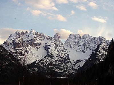
The favorable geographic location, the vicinity of some of the most famous peaks in the Dolomites (amongst which are the renowned Tre Cime/Drei Zinnen), the abundantly sunny climate – and the multifold cultural and sports activities are all contributing factors to its success as a summer and winter resort alike, both in Italy and – because of the cultural roots of the area – in the neighbouring German-speaking countries too.
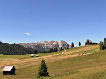
An interesting artistic and natural panorama is available to the visitor: old chapels and churches, ancient farmsteads (‘masi’), paths by both man-made and natural habitats, lakes, extensive woodlands, and the proximity of two Natural Parks (“Dolomiti di Sesto/Sextnerdolomiten” and “Fanes–Sennes–Braies/Prags”), both rich in flora and fauna, all form a rich tapestry of ever-changing possibilities for the visitor.
Dobbiaco was widely spoken about when the heir prince of Germany-Sachsen Friedrich Wilhelm sojourned here with his family in 1887 after being stricken by illness, and many identify this date as the starting point of tourism in Dobbiaco.
In the following years the first hotels started to be built, such as Grand Hotel Baur (1870) in the Val di Landro/Höhlensteintal, Hotel Germania in 1890, Seehotel in 1893, Hotel Union in 1900 and the Bellevue in 1902; many other hotels followed in their wake.
Hotels started also to be erected in Carbonin/Schluderbach, such as the Schluderbach and the Sigmundsbrunn – luxurious facilities which were frequented by a rich clientele, and had therefore particularly high prices.
Only at a much later stage – indeed, only after World War II – did mass-tourism start to develop in Dobbiaco, and today this is one of the foremost tourist destinations in the whole of South Tyrol, with more than 500,000 presences every year, 75% of which come from Italy, the rest mainly from neighbouring Germany and Austria – but the sheer beauty of this place would definitely deserve it to be better known far and wide.
Walks and Treks Around Dobbiaco
Of course, being as we said earlier one of the main gateways to the Dolomites, the area around Dobbiaco lends itself perfectly to walks and treks, especially in altitude.
The Dolomites extend specifically to the south of town, and can be accessed through the narrow valley that leads first to the Lake of Dobbiaco/Toblachersee and then further into the Val di Landro (German Höhlensteintal), by the Lago di Landro/Dürrensee.
This latter location provides a first entry point towards the area of the Tre Cime/Drei Zinnen – albeit by means of a long and steep path that ascends the narrow canyons of the Valle della Rienza/Rienztal and Val Rinbon, taking one eventually to the Rifugio Locatelli/Drei-Zinnen-Hütte (2,405 m), an ideal base from which to explore the area (see the 'classic' picture of the Tre Cime/Drei Zinnen below, taken by the Lago di Landro/Dürrensee).
If you're in for an easier option, you can just continue all the way to the Lake of Misurina, from where the classical ascent can be done either through the toll road or the path that starts past the Lake of Antorno (for more details, see the Tre Cime/Drei Zinnen page).
More trails ascend on the other side of the Val di Landro/Höhlensteintal, and lead – amongst other places – to Rifugio Vallandro/Dürrensteinhütte (2,040 m), a mountain hut on the edge of the beautiful high pastures of Prato Piazza/Platzwiesen, from which it is also possible to descend by the shores of the picturesque Lago di Braies/Pragssee.
Otherwise – but you would need a bit more training for this – there is also the possibility to ascend from Prato Piazza/Platzwiese to the peak of Picco di Vallandro/Dürrenstein (2,839 m), which would reward you with a wide open view. An easier option from there is to climb up Monte Specie/Strudelkopf (2,307 m).
There are at least three mountain huts on the plateau, on which you can rely for accommodation and/or a hearty meal: Rifugio Prato Piazza/Platzwiesehütte (1,991 m) and Rifugio Vallandro/Dürrensteinhütte (2,040 m), open all year round, while a third facility – set in a beautiful wooden building – is open summer only (see below an image of the upland pastures at Prato Piazza).
More treks in altitude are possible from the Val di Landro/Höhlensteintal and include Monte Piana (2,350 m) – a table mountain made infamous by WW1 events, where one will find a mountain hut (Rifugio A. Bosi; 2,205 m) that hosts a little museum dedicated to the war. There are two main ways to hike up Monte Piana; one is the so-called Sentiero dei Pionieri (Pionerweg) from Lago di Landro/Dürrensee, while the other is known as Sentiero dei Turisti (Touristenstieg), from Carbonin/Schluderbach. Both options are relatively easy, with some exposed sections only near the summit. More information on all these options will be found on the Dolomiti di Sesto/Sextnerdolomiten page (see below an image of the sea of rock of the Dolomites, taken from the flat summit of Monte Piana and accompanied by a dramatic autumn sky).
North of town, albeit in a less scenic and frequented area (these hills are not Dolomite in nature, but rather crystalline and therefore more rounded), there are also plenty of possibilities for interesting walks (in fact, especially in the summer, this is a very good alternative in order to avoid the crowds that can make walking in the Dolomites at times a bit overwhelming).
A good option is to follow the Toblacher Hohenweg – a collective series of paths and trails which reach the highest peaks north of Dobbiaco, such as Corno Alto/Hochhorn (2,623 m) and Corno di Fana/Toblacher Pfannhorn (2,663 m). This may make for an interesting trek that takes one to the ridge marking the border with Austria first, and later follows a circular route with a descent into either San Candido/Innichen or the Valle di Casies/Gsiesertal. These are relatively easy excursions which would also be crowned by rewarding views at the top.
I would like now to describe a section of the Toblacher Hohenweg in more detail, outlining the possibility of a circular trail starting and ending in Dobbiaco – a slightly more demanding option. The best way to emabark on this is by entering the Valle San Silvestro/Silvestertal and reach Malga San Silvestro/Silvesteralm, where food and drink are available (1,800 m).
From there, the ascent begins in earnest to the Cornetto di Confine/Marchkinkele (2,546 m) first, and then follows with the traverse to all the further summits: Sasso Planca (Blankenstein; 2,483 m); Corno Fana (Pfannhorn; 2,663 m); Corno Alto (Hochhorn; 2,623 m) and Monte Calvo (Golfen; 2,493 m), from where starts the descent to Franadega/Frondeigen (1,650 m) and then again into the Valle San Silvestro/Silvestertal (by the Rifugio Genziana/Enzianhütte).
This circular trail takes about 8/10 hours to complete, so it is quite a demanding trek that should not be undertaken lighty, even though there is the possibility to break it up in places.
Other easier options include the trails that go under the names of Römerweg (The Way of the Romans), Bestimmungsweg and Jakobsweg. While the latter one follows the course of the Drava/Drau on the southern side of the valley, the first two meander on the beautiful verdant meadows north of town, and take one in the direction of Monte Rota/Ratsberg (1,877 m) and Kirchberg (1,715 m), allowing also for a descent in Villabassa/Niederdorf or Monguelfo/Welsberg.
The Lago di Dobbiaco/Toblach Lake Interpretive Nature Trail
The Dobbiaco/Toblach Lake loop interpretive nature trail comprises 11 stations and affords both young and old an excellent opportunity to discover the local wonders of nature. The trail provides visitors with detailed information concerning the flora, fauna and geomorphology of the area. Some of the stations afford the opportunity to test one’s skills; for example, at station 4 visitors are asked to identify the pillars that are camouflaged by their colors, in the manner of animal camouflage, while at station 9 they can find out whether their broad-jumping abilities match those of the forest denizens.
As one of the last remaining wetlands in the province, the Dobbiaco/Toblach Lake is much frequented by birds. During the bird breeding seasons in spring and fall, some rare species are also observed by the lake shores. The trail is around 2.5 kilometers long, and it can be hiked in just under an hour.
What Makes Dobbiaco so Unique?
To recap, here is a list of the main attractions and points of interest in and around Dobbiaco:
– The Tre Cime di Lavaredo (“Drei Zinnen”) are perhaps the most famous sight of the entire Dolomites, and their famous northern face falls entirely within the territory of Dobbiaco;
– The Lake of Dobbiaco/Toblachersee – originated by a landslide – is ideal for quiet walks, or for outings with small boats that can be rented in situ;
– The Val di Landro (Höhlensteintal), with the Lago di Landro/Dürrensee (another lake), is largely unspoilt, and offers numberless possibilities for walks and hikes, comprising a strenuous ascent towards the Tre Cime/Drei Zinnen;
– The same could be said for the areas protected by the two Natural Parks of the Dolomiti di Sesto/Sextnerdolomiten and Fanes – Sennes – Braies;
– In Carbonin Vecchia/Altschluderbach one can still visit the composition house used by the composer Gustav Mahler; here there is also a small animal park, especially aimed at those who are not able to walk and cannot get the chance to spot wildlife in its natural setting;
– By the impressive compound of the Grand Hotel are hosted – along with many other facilities – the visitor centre for the Dolomiti di Sesto/Sextnerdolomiten park, the Celtic horoscope and the three log cabins of the “Magical World of the Forest”: an information trail aimed at explaining the importance of woodland conservation and of forest ecosystems;
– The Herbstenburg estate, with its towers and characteristic ‘Erkers’ (Tyrolean bow-windows), is considered one of the most beautiful buildings of its genre in the area;
– The parish church of St. John the Baptist is deemed to be the best preserved Baroque church of the whole valley, while the Sanctuary of Santa Maria/Aufkirchen is well known since ancient times as an important place of worship and pilgrimage;
The historical Via Crucis, also, is Tyrol’s most ancient, and starts in the middle of the village by the parish church, then takes the visitor through some of the most beautiful meadows around town, with pastoral views;
– The information circuit connected to the District heating power plant (“Centrale termica a biomassa”) is one of the foremost in Europe: powered with the waste products of the wood mills and timber industry, this plant provides central heating for the two municipalities of Dobbiaco and San Candido/Innichen;
– The “Ferrovia delle Dolomiti”, which had known moments of glory during the winter Olympics of Cortina in 1956, was later abandoned and fell into disrepair – quite an inglorious end – but has today come back to life, even though in a different guise: it is now widely used both as a cycle path over the summer and for cross-country skiing in winter;
– Lastly, Mondolatte Tre Cime – the social dairy farm – also serves the two towns of Dobbiaco and San Candido/Innichen, offering an interesting circuit which makes for an educational (as well as tasty!) visit.
To conclude, the sheer beauty of this place would definitely deserve to make Dobbiaco/Toblach better known far and wide, as despite being massively frequented it has managed to retain a quiet and charming composure that have been all but lost in so many others of the mass-tourism resorts of the Dolomites.
Return from Dobbiaco to Dolomites
Return from Dobbiaco to Italy-Tours-in-Nature
Copyright © 2019 Italy-Tours-in-Nature

New! Comments
Have your say about what you just read! Leave me a comment in the box below.