- Italy Tours Home
- Italy Ethos
- Tours 2023
- Blog
- Contact Us
- Dolomites
- Top 10 Dolomites
- Veneto
- Dolomites Geology
- Dolomiti Bellunesi
- Cortina
- Cadore
- Belluno
- Cansiglio
- Carso
- Carnia
- Sauris
- Friuli
- Trentino
- Ethnographic Museums
- Monte Baldo
- South Tyrol
- Alta Pusteria
- Dobbiaco
- Emilia-Romagna
- Aosta Valley
- Cinque Terre
- Portofino
- Northern Apennines
- Southern Apennines
- Italian Botanical Gardens
- Padua Botanical Garden
- Orchids of Italy
The Lagorai: Wild Mountain Range in Eastern Trentino.
Geography
The Lagorai range is a mountain group situated in Eastern Trentino, and it represents one of the most natural areas of the province, including some of the most extensive stretches of relative wilderness in the south-eastern Alps. Its name has its roots in the word ‘lago’ (lake in Italian); in fact, numerous are the lakes of various dimensions that can be found at different altitudes within this vast mountain chain.
The Lagorai range is extended – from a geologic and geographic point of view – over a vast area comprised between Monte Calisio (east of Trento) and Passo Rolle (1,984 m; in the Primiero sub-region), for an overall length of about 70 km.
Many valleys come down from this extensive range, amongst which are those of Primiero to the south-east and the Val Vanoi to the south, as well as the smaller tributary valleys of Val Campelle and Val Calamento – these being both side valleys of the main Valsugana; the Val Cismon lies to the east, while the Valle dei Mocheni and the Pinè plateau are to the west. The Cembra valley lies to the north-west and the Val di Fiemme and Val Travignolo are to the north: all these valleys and regions mark the exact geographic limits of the range.
Geology
The geographical location of this long mountain chain is at the margin of – if not right outside – the territory of the Dolomites, as traditionally defined. In this sense, the term identifies a vast area of Eastern Trentino occupied by the many peaks and summits bearing the overall name of ‘Lagorai’, and formed for the most part by porphyric rocks belonging to the Adige valley vulcanites, but also by metamorphic rocks (Phyillites, schists, Gneiss, etc) belonging to the metamorphic basement of the Southern Alps, which comprises many small tributary valleys afferent to the above mentioned main valleys, all rich in waters, lakes, meadows and pastures dotted with ‘malghe’.
From a strictly geological-structural point of view, though, the Lagorai range is considered part of the Dolomites, and its rocks mainly belong to the Adige Valley Vulcanic Group – a potent succession of ignimbrites, lava and other deposits surfacing in South Tyrol and Eastern Trentino, deposited during the Permian in a time interval comprised between 290 and 274 million years ago. These rocks form part of an articulated volcanic system whose products currently emerge over a vast area of the Southern Alps – roughly between the Eastern Dolomites to the east and Lake Maggiore to the west.
The Lagorai range is constituted mainly of solid banks, which are evidence of volcanic explosions, and of lava flows and solidified lava domes, expressions on the contrary of effusive activity; both are overlaid on top of older metamorphic rocks belonging to the southern Alpine metamorphic basement. From a tectonic point of view, at large, the whole system belongs to the Southern Alps.
According to the most credited hypothesis, the magmatic activity was originated in a trans-extensive tectonic context, with the development of basins delimited by ‘strike-slip’ faults laid on top of thinner upper crusts, which conditioned the subsequent rise and positioning of volcanic magma. Geologic-petrographic research on the rocks in the occasion of most recent studies for the laying out of a Geologic Map of the area has pointed out to a stratigraphic succession that from the Phyillites of the basement displays the following layers, going upwards:
1. Castelliere Formation: this is a potent succession of ignimbrites, costituted by at least three simple layers, indistinct and superimposed;
2. Cembra Formation: it is composed of small bodies, lava flows and basaltic/andesitic layers;
3. Gargazzone Formation: a succession of ignimbrites costituited by at least four simple cooling units; each unit is composed by a characteristic sequence, typical of ignimbritic flow, which starts at the base with layers of breccias, conglomerates and tufa, fragments of basement and andesitic lava, sometimes interspersed with ashes; this layer is often discontinuous and with a variable thickness. A thicker layer then follows, characterized by more or less regular columnar cracks originated by cooling, and lastly a concentrated layer of pumice, which gives the rock a coarse and less compact aspect.
4. Regnana Formation: a huge building composed of solidified lava flow, associated with vulcanites of the same composition;
5. Malga Aie Formation: a smaller ignimbritic unit;
6. Ora Formation: a last potent episode of riolitic/ignimbritic unit.
Formations no. 3, 4 and 6 are then covered by a layer of Val Gardena sandstone.
Numerous sin-volcanic faults are also present; they are predominantly distensive and associated with an activity that conditions the placing of vulcanites, causing important variations in thickness as well as a stratigraphic lacuna. These faults have undergone reactivations – probably during the Triassic and mostly during the Alpine orogenesis, when the old Permian structures have been re-enlived, with such phenomena as sliding or inverted faults.
From a geo-chemical point of view, the rocks of the central Lagorai range can be identified as typical alkaline associations, sometimes normal and sometimes richer in potassium. The presence of both acid (riolites) and basic (andesitic-basaltic) products indicates a bio-normality, resulting from the different interactions between the magma of the mantle and material deriving from the Earth’s crust.
In spite of the alkaline affinity, typical of orogenetic habitats, this geologic activity was mainly developed in the context of an extensive-trans-extensive environment. The erosion, operating in a selective way, has then determined a decrease towards the north of the steep southern rock face, caused also by an undermining of its base.
General Description
The area to the north-east of the massif – surrounding Monte Colbricon (2,602 m), at the Cavallazza (2,324 m) and around Passo Rolle (1,984 m) – lies within the boundary of the Parco Naturale Paneveggio – Pale di San Martino, which aims at safeguarding and controlling the often rare or endangered bird and mammal population.
In the area of Passo Rolle, also – at an altitude just below 2,000 m – one can see the Colbricon lakes, presenting traces of very ancient human settlements, amongst which are hunters’ camps from the Neolitic.
Without an excessive exploitation by skilifts and ski slopes (with the exceptions of those at the Cermis, Passo Rolle, San Martino di Castrozza and the Panarotta), the Lagorai presents a relatively intact Alpine landscape; the main human activities which have slightly modified the natural environment are connected with traditional cattle farming and timber production. At the moment when there is a reprise of the vegetative activity each spring, animals (cattle, horse and sheep) are transferred to the extensive pastures above the woods, so that they can spend the summer months grazing on fresh grass – a fact which has partly altered the composition of vegetation over time.
Tourist facts
The main gateways to the highest parts of the Lagorai range are through Passo Rolle (1,984 m; which connects the Primiero and Fiemme valleys through the Val Travignolo); the Passo Manghen (2,047 m), connecting the Valsugana with the Val di Fiemme (closed in winter) and the lower Passo di Redebus (1,455 m), which links the Valle dei Mocheni with the Pinè plateau.
In the area there are numerous possibilities for trekking and hiking; there are also some noteworthy long-distance trails, such as the Translagorai – a 50 km long route that starts at the Panarotta and leads all the way to Passo Rolle through a series of paths, mule-tracks and even old trenches and military roads from WW1; in fact, one can sometimes even find remnants from the war while walking. As a memento, over most of the peaks there is a cross, together with a book where one can leave a trace of his or her passing.
This long mountain chain is also particularly apt for the practice of free Alpine skiing, as most summits can be relatively easily reached and many offer first-rate slopes. Particularly appreciated for its beauty and length, in that respect, is the range’s highest mountain, Cima di Cece (2,754 m).
Main Peaks and Alpine Huts
The main summits in the area of the Lagorai are located along its southernmost ridge, aligned with a SW-NE direction from Passo Manghen to the Val Sadole. These comprise (from the highest) Monte Laste de le Sute (2,616 m); Cima delle Stellune (2,605 m); Cima di Lagorai (2,585 m); Cima delle Buse (2,574 m); Cima di Coppola (2,547 m); Cimon di Lasteolo (2,544 m); Cima Busa Alta (2,513 m); Monte Cauriol (2,494 m); Kraiserspitz (2,490 m); Monte Cardinal (2,481 m); Monte Ziolera (2,478 m); Cima di Canzenagol (2,457 m); Montalon (2,435 m) and Monte Formentone (2,414 m).
The main ridge then suddenly changes to an E-W direction between Forcella Coldosè (2,182 m) and Passo Rolle (1,984 m), where we find Cima Cece (2,754 m) – the highest peak of the whole range, followed by the Cime di Ceremana (2,699 m); Cime di Bragarolo (2,697 m); Cima Valon (2,678 m); Colbricon (2,602 m), above the famous lakes; Monte Coltorondo (2,530 m); Cima di Valmaggiore (2,479 m); Cima di Valbona (2,413 m) and Cavallazza (2,324 m).
The main Alpine huts in the area include (again in decreasing order of altitude): Rifugio Erdemolo (2,036 m) at the Pizzo Alto; Rifugio Sette Selle (2,014 m) in the Val del Laner; Rifugio Colbricon (1,927 m) – probably in the most renowned location, by the Laghi di Colbricon; Rifugio Spruggio (1,900 m) at the Alpeggio Malga Spruggio; Rifugio Cauriol (1,594 m) in the Val di Sadole and Rifugio Serot (1,566 m) above Roncegno Terme. We finish off with Rifugio Refavaie (1,091 m), the lowest one, at Località Refavaie in the Valle del Vanoi.
The Lagorai Eco-museum
Lagorai is the evocative name of a still relatively untamed mountain chain situated in south-eastern Trentino, not far from the boundary with Veneto; in fact, it shares geographically some characteristics that make it more akin to the val Cismon area, near Feltre.
Within the Lagorai range lies one of the region’s Eco-museums , part of a network including six other similar initiatives spread over the province of Trento.
These Eco-museums have been created in several valleys of Trentino, and follow the idea of conceiving initiatives in areas where not very much is on offer in terms of established tourist routes, while at the same time there is an urge to value the traces of past activities still to be seen and appreciated.
One of such Eco-museums is precisely in the Lagorai area, and it takes its name from this extensive range of relatively wild and still untamed mountains.
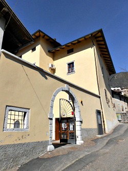
This mountain chain is partly comprised within the boundaries of the Natural Regional Park of Paneveggio – Pale di San Martino. It is situated in the medium Valsugana, in the section of valley included between the villages of Strigno and Roncegno, and it includes the communities of Carzano, Telve (see image above), Telve di Sopra and Torcegno.
This is a section of valley where there are still traditional agricultural activities going on – especially the terracing on the hillsides, where chestnuts are being cultivated in the old way, with an open system of terraces boundaried by dry stone walls.
But the built environment is interesting too: in this area there are mostly stone buildings, covered with a wooden cladding which usually forms a lighter superstructure when compared to that of other areas (usually wood takes precedence at higher altitudes, while this area is still realtively low-lying).
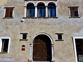
In fact, as well as for its vernacular houses, some villages such as Telve are noteworthy as among its houses there are also good examples of the so-called ‘noble architecture’ (see image below), easily recognizable for the brightly painted colors of the exteriors, the nobility of the stone arches framing the main entrances, and the iron railings at the windows.
The Trails of the Eco-museum
Within the territory of this Eco-museum there are several possibilities for hikes of varying degrees of difficulty – some very easy in fact, while some other trails are more educational in nature.
For instance, the riverside park in Carzano has been created in order to protect the village from the floods of the Maso stream, but it includes a distinctive pond, and it has also been equipped with picnic tables that make it the ideal family destination to spend a few hours together in a quiet spot, within the typical Lagorai green setting.
Another destination is the so-called ‘Ethnographic wood-way’ (“Sentiero Etnografico del Legno”), dotted with informative boards that allow to aknowledge oneself with the importance of wood as a resource in these communities’ past – but also in the present. At the end of the trail, it is possible to take a plunge into the art of woodwork and its tools, with a visit to the Wood Museum in Marolo.
Among these hills, beautiful trails can be followed towards the wild Lagorai mountain chain, but pleasant walks can also be undertaken in the lower section of the Valsugana among chestnuts, while looking for traces of the past in the form of abandoned castles; the Castellalto ruins (see image below), for instance, can be reached with an easy 30 minutes’ walk just above the village of Telve.
Some of the walks around here are also equipped to be either horse-ridden or followed with a mountain bike. It is a different story in altitude, though, when it gets to the higher reaches of the mountains, where the so-called ‘malghe’ (in the local language) can be found.
These are buildings which were traditionally used by shepherds as sheep and dairy-pens, and they are still useful today in terms of understanding how the landscape was managed traditionally, especially when it comes to following the different cattle farming practices during the course of a year (the yearly rhythm of taking the animals up and down the mountain slopes for grazing).
As for the cheese-dairy farms themselves, the memory they carry of a symbiosis between man and nature still pervades these traditional buildings located on wide pastures usually above 1,400 metres of altitude, with several ‘malghe’ that allowed summer cattle grazing; in the area of Telve alone there are 9 of these dairy farms, some of them still in use.
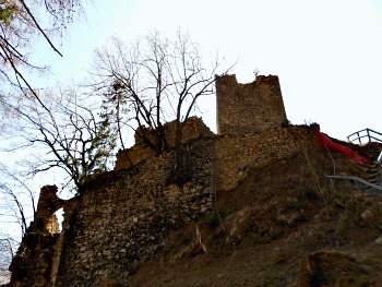
The Castellalto
The ancient Castellalto jurisdiction (see an image of the castle ruins above) stretched across Carzano, Telve, Telve di Sopra and Torcegno municipalities; the underlying idea of the Eco-museum is that of reuniting an area which is quite similar for its cultural background, in order to recreate an historical entity whose current conception, though, stems from a sustainable development approach.
The aim is that of crossing administrative boundaries in order to enhance the environmental, historical, cultural and anthropic (human) awareness of a wider area, since the four communities have – to a large extent – a common past heritage, being all gathered together (in Medieval times) under the Castellalto family rule.
From this aspect follows the subheading of Lagorai-Castellalto Eco-museum, to mark the close connection between the four communities and the entity they create as a whole thanks to the ‘shared’ Lagorai range. This is for the ‘natural’ connecting aspect, while on the historical front this unity translates into the common legacy of the Castellalto lordship.
The manor from where the jurisdiction takes its historical name dominates the area – since Medieval times – from a hilltop on the slopes of Monte Musiera; it has lived its most glorious moments with the De Thelvo family (who took their name from the village), and it was the setting of many legends, the most famous being probably that of the “Sasso del Secio e della Secia” (‘the two buckets’ stone’).
Despite the many changes occurred over the past forty years, the four small townships have been able to preserve their peculiarities, thanks especially to an agro-forestry and pastoral economy which was dedicated to promote low-impact actions and solutions to today's environmental challenges.
The Museum of Customs and Traditions
This is a valuable collection of items presenting the farming and rural reality of the hamlet and its traditions; through this exhibition the story is told of how people used to live in Telve until not long ago.
The museum is divided into two sections; at the ground floor, a cellar and a barn have been recreated: these spaces are structured inside the same rooms where the original objects and materials used to be when the building hosted an ancient farmhouse – so they have been brought back here, where they belong.
Next to the Museum's rooms, a workshop for wood- and metal-work has also been reconstructed, in order to recall how the manufacturing of tools with these materials had been a characteristic activity within the community – and in many respects it has remained so up to this day.
The other half of the Museum (on the upper floors) hosts a rich exhibition of objects and utensils of daily life, while a smaller section is dedicated to room reconstructions: a kitchen and a bedroom show the visitors the simplicity of everyday domestic life in old times; a traditional cheese dairy farm has been recreated here as well.
A characteristic that marks this tiny Museum is that all the items on display in it – from the most valuable to the humblest – have been kindly donated by local people. The reason for establishing it in the first place – within the context of the Eco-museum – was precisely to highlight its importance as visual memory of a harmonious way of life that ideally connects the past to the present, in order to keep alive those identity-making processes that are luckily not yet completely forgotten.
The “Vie della Storia” (Historic Ways)
Roads have always helped people to shape and cultivate meaningful relationships between them over distant lands from Pre-history right up to the present times.
The Valsugana and the Roman way via Claudia Augusta thus represent a bridge linking the Adriatic sea to Germany across the Alps – so, in many ways, this area connected two ‘worlds’ with two very distinctive cultures: the Mediterranean and the Germanic. Nowadays, the via Claudia Augusta project aims to recuperate and re-evaluate this Roman heritage and its historical connecting role.
This is done in the context of the “Vie della Storia” (historic ways) project, which was started in Valsugana and aims to connect different territories and populations through their traditional economies and experiences.
The idea behind this project is that of putting into perspective all the cultural, territorial and economic factors that are capable of strengthening the attraction of areas traditionally crossed by huge numbers of visitors. And walkers, today, can still peacefully unite – like old time travelers – along these historical trails so deeply rooted at the core of European history.
The Eco-museum in Connection
Another Eco-museum is in the neighbouring val Vanoi – a small valley situated exactly on the opposite side of the Lagorai range, to the north-east.
As already stated above, it is also worth reminding that this mountain chain is partly comprised within the boundaries of the Natural Regional Park of Paneveggio - Pale di San Martino.
Another area bordering with the Lagorai Eco-museum is the Tesino plateau, located in a slightly peripheral position at the foothills of the Lagorai range to the south-east.
Walking in Nature
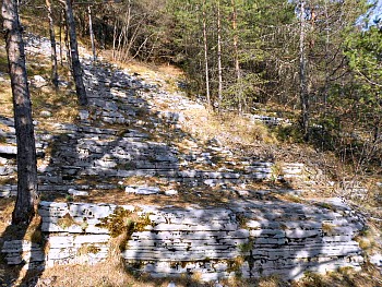
With the help of this page, start planning your journey of discovery of the Valsugana and Lagorai range, where more than 100 mountain paths wait for you in a wild and intact nature – in woods and meadows, along streams and mule tracks, between old houses and Alpine lakes (above, see an image of the interesting rocks that surface along the path to the Castellalto ruins).
These are only a handful of all excursions the that are possible in the area, and the suggested tracks are suitable for everyone – even those with not so much training. Faithful companions of this adventure will be the backdrop of the magnificent peaks of these mountains, the wild animals that – with a little luck – you’ll meet along the paths and – last but not least – the rare floral species that will add color to your trip.
The Granite Way. The Granite Way is a splendid highway ring in the unique area of the Cima d’Asta mountain group – Cimon Rava, in the Lagorai range. The highway follows a network of ancient paths and former military roads which start at Malga Sorgazza and then go on to meet two mountain huts in the area: Rifugio Ottone Brentari and Caldenave. You can follow the path in a clockwise or anti-clockwise direction. This is the only long-distance trail: 16 hours to be covered over three days; booking in the refuges (huts) is recommended in the high season.
1) The Salesà Way. This itinerary stretches up to the slopes of Orno and along the ancient pathway that connected Zivignago (a hamlet belonging to the municipality of Pergine Valsugana) and Falesina, one of the two hamlets that make up the village of Vignola-Falesina. It gets its name from the paving stones that are still present along the part of the route. There are many interesting remains of the anthropic (human) activity in the area and, in particular, the cultivation of chestnut trees (3h).
2 The Natural Art Walk. The Natural Art Walk of Arte Sella winds its way along a forest track road for around 3,5 km through the Sella valley woods. Accessible all year round, it is interesting to see the changing works of art along in the different seasons. Daily from 1st April to 31st October – and at weekends during the wintertime – the Arte Sella association also organizes events and exhibitions, and invites artists to create new works of art. During this period there is a charge to visit the ‘Vegetal Cathedral’ and the Malga Costa farmstead. The roundtrip takes about 3h.
3) The Ogre’s Bridge. The Ogre’s Bridge is one of the most important ‘natural bridges’ that can be found in the north of Italy. It is made up of two giant rock pillars upon which lies a large mass of Dolomite. It can be reached from the small church of San Vendemiano in Ivano-Fracena or from the little church of Rocchetta in Ospedaletto (2h).
4) The Nature Path of the Gnomes’ Secrets. This trail is divided into two itineraries, marked with different colors (one red – shorter, and the other green – longer); however, both are circular. Along the paths there are stands with information; the relative texts and pictures – which have been created by the primary school children of Tenna – make these walks even more enjoyable and interesting (1h).
5) The 1752 Milestone Way. This path mostly follows the boundary between Veneto and Trentino, along the controversial boundary that once divided the ‘Serenissima’ Venetian Republic and the Austrian-Hungarian Empire. The path is well-known, and because of its distance, it is advisable to split the journey over two days; perhaps choosing the Marcesina hotel as the starting point for the second day (4h45 +4h20).
6) The Chestnut Way. This path is dominated by majestic chestnut trees and passes through some of the villages in the Middle Valsugana valley. The path can be reached from different points and diverse ring routes can be tackled, depending on the time availabile and physical training. The countryside along the path surprises because of its colours and varieties: here nature and history are at their best, and the ancient terraces are the perfect host, as it is proudly shown by the most precious of local treasures: centuries-old gnarled chestnut trees. This is a trail connecting several towns and can be broken down into sections of different lenghts.
7) The “Green Way” Mine Path. This walk, which starts from the Mining Museum, takes you to visit and get to know the important mining sites of Calceranica and Bosentino. The path winds its way along an ancient Roman road and continues through enchanting woods and waterways in an environment of surprising and varying beauty, then it makes its way back along the Miner’s path (3h).
8) The Malghe and Zirmi Path. This path was used in the 1930s by the mountain farmers of the Campelle side valley; it connects the pastures of the new Malga Casarina (an ‘agriturismo’) with the Malga Caldenave meadows – now a splendid mountain refuge – and it follows a path that is characterized by century-old pine trees (Pinus cembra), locally called ‘Zirmi’ (3h).
9) The King Fravort Path. This is a mountain path along which one can enjoy splendid views, and it leads from Panarotta to the top of Monte Fravort. This mountain peak was heavily guarded during WW1, and you can still see the remains of the trenches (4h).
10) The Vezzena Highlands and “Pizzo di Levico” Fort Trail. From the Vezzena plateau it is possible to go to the “Pizzo di Levico” Fort, which was used during the First World War as a military outpost and as a traffic checkpoint that looked out over the Valsugana (3h).
11) The Valtrigona Oasis Trail. This is the only area protected by the WWF in the whole of the Alps. The Valtrigona Oasis, with its Nature path, offers an itinerary through silent larch and pine forests, where you can discover the animal life and flowers of this high mountain area. The oasis is truly an open-air museum, in whose book visitors can read stories that date back thousands of years (3h).
12) The Flowers’ Way. This is a path of remarkable botanical importance, but also of geological and historic interest, which winds its way from the Brocon pass (in the Tesino area) at the altitude of 1,616 m. This mountain path boasts a wealth of botanic plants as well as evident signs of WW1 (2h).
13) From Palù del Fersina it is also possible to reach the Rifugio and Lake Erdemolo, situated above the village of Palù itself in the Valle dei Mocheni. The lake is immersed in nature and surrounded by magnificent mountain peaks of particular fascination. If you don’t want to go back along the same track, it is possible to close the ring by reaching Rifugio Sette Selle and there follow the path that returns to Palù del Fersina via another route.
Return from Lagorai to italy-tours-in-nature
Copyright © 2013 Italy-Tours-in-Nature

New! Comments
Have your say about what you just read! Leave me a comment in the box below.