- Italy Tours Home
- Italy Ethos
- Tours 2023
- Blog
- Contact Us
- Dolomites
- Top 10 Dolomites
- Veneto
- Dolomites Geology
- Dolomiti Bellunesi
- Cortina
- Cadore
- Belluno
- Cansiglio
- Carso
- Carnia
- Sauris
- Friuli
- Trentino
- Ethnographic Museums
- Monte Baldo
- South Tyrol
- Alta Pusteria
- Dobbiaco
- Emilia-Romagna
- Aosta Valley
- Cinque Terre
- Portofino
- Northern Apennines
- Southern Apennines
- Italian Botanical Gardens
- Padua Botanical Garden
- Orchids of Italy
The Massenzatica Fossil Dunes Mark an Ancient Coastline near the Po Delta.
The
Nature Reserve “Dune Fossili di Massenzatica”
The Past Written in the Landscape: Walking on the Coastal Dunes of 3,000 Years Ago
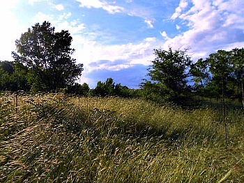
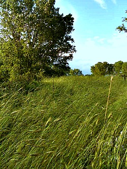
The term ‘alluvial plain’ recalls to mind a completely uniform territory, devoid of any elevations or hollows: in actual fact, the seemingly flat lands of the Po Delta are punctuated by humps and dune-bars that intertwine on vast areas, mostly below (the) sea (level). In general, these differences in gradient reflect the history of land formation and the interventions performed by man in these historically unstable territories. Despite the artificial leveling that was carried out in some places, the reliefs constituted by the ancient littoral dunes are in fact still recognizable – as are the old river beds, which still stand out – while the large depressions are a consequence of the draining of marshland and of subsidence phenomena in general. In a land constantly contended from water, areas which were in a condition of topographic ‘high’ – generally sandy, well drained and with good carrying capacity – have, precisely for this reason, always constituted preferential terrains for the founding of settlements, and the passage of the connecting routes (a typical image of the reserve – with the characteristic tall grasses – is displayed above).
The Old River Beds (‘palaeo-rivers’): Traces of Rivers that Were, and that Have Now Disappeared
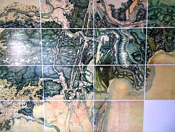
The rivers that used to cross this plain generally had a very slow flowing capacity; the sediments became therefore progressively deposited in the river beds, so that the rivers tended to become raised, when compared to the surrounding landscape. During flood events, the majority of sediments became deposited close to the breaking point, thus creating natural embankments. In fact, in the history of these plains, the hydrographic layout has often been revolutionized by breaches of the river Po (the so-called rotte); among the most notable ones, we have at least to mention the breach at Sermide (8th century) and – most importantly – the Rotta at Ficarolo (1152) that have significantly deviated – often in quite dramatic ways – the historic course of the different branches of the Po. The ancient river beds – no longer used by water – generally remain, however, visible as a marked elevation on the ground (below, see a reproduction of the large map displayed in the visitor centre at Massenzatica, showing the historic region of the Po Delta).
The palaeo-dunes: Where Waves Used to Crash
The coarser sediments transported downstream by the rivers then moved along the coastline under the action of (the) waves (differently from the finer sediments, which were dispersed in the open sea). The sand particles – to which one must add fragments of shells – were then pushed away by the wind towards the interior, where they became trapped by the plants that first managed to colonize the beaches. Progressively, as the coastline advanced as a consequence of the progressive accumulation of alluvial sediments, the oldest dune-bars are found more and more towards the interior, as they became colonized and stabilized by less specialized plant species. The climatic variations have strongly conditioned the establishment of the dune-bars, sufficiently raised so to leave a trace over the land. In the periods with a more humid climate, characterized by more frequent floods – and with greater quantities of sediments taken to the river outlets by the strength of the currents – the coastline grew at a faster pace, not leaving enough time for the building up of high dune systems. On the contrary, in very arid periods the supply of sediments brought by the rivers diminished significantly; therefore the coastline was maintained in the same position for longer, allowing the coordinated action of waves, wind and plant cover the time to build the sand-bars along the littoral – by now quite far from the actual coast, but still recognizable today.
Origin and Evolution of the Lands Around the Po Delta
Several million years have passed from the raising of the Alps and of the Apennines; the so-called ‘Padan Gulf’ – still present about two million years ago – was gradually filled by (the) detritus transported by the progenitor of the Po and its tributaries.
The plain over which the “Dune di Massenzatica” rise today has known alternated phases of expansion and regression. While the detritus transported by the rivers were deposited at the foot of the mountain chains, the ‘Padan Gulf’ continued to sink, thus determining deposits thousands of metres thick, but leaving – until one million years ago – these lands to the dominion of the sea.
With the beginning of the Quaternary – the current geologic era – sedimentation took over subsidence, caused by a slumping of the soil due to both a downward movement of the ‘Padan Gulf’ and compression of the detritus deposited thus far.
It is in fact precisely during the Quaternary era that the effects of the great glaciations became superimposed to the slow progression of the young plain. During the glacial periods, enormous masses of water remained imprisoned over the continents in the form of ice, determining a lowering of the sea levels and consequently the emersion of the greatest part of the Adriatic sea.
Thus, whoever had been in Massenzatica during the last glaciations – which was over about 10,000 years ago – in order to reach the beach and the sea would have had to walk roughly until where Ancona is today, where the coastline ended at the time, and gave way to emerged land. Incidentally, we should also be reminded of the fact that it is precisely in this period that the Neanderthal man was progressively being substituted by the Cro-Magnon man.
At the end of the glaciations the water invaded again the lands that had previously been emerged: in 3,500BC the area around Massenzatica was once more occupied by the sea, and by now the coastline was passing where the village of Massa Fiscaglia is located today (about 20 km inland to the west).
Slowly but surely, the plains began to rise again, thanks to the sand supply that was carried by the digressions of the final stretch of the Po – whose two main branches during the Bronze Age were passing along a line Sermide-Adria to the north and Ferrara-Ostellato to the south.
It was only between the end of the Bronze Age and the beginning of the Iron Age that the littoral sand-bars were formed – and these can still be seen not just in Massenzatica but also, further north, in San Basilio and Rosolina. About 3,000 years ago, at the back of these coastal dunes there were still wide marshy basins from which emerged the raised sections of river beds.
In 132BC the Roman Consul Publio Popilio Laenas ordered the tracing of the Via Popilia, which connected Ravenna to Adria, passing over the dune-bars at Monticelli. Both in the area of Monticelli and Massenzatica there have been archaeologic finds dating to the Roman time: trachytic traces of the original pavement thas can still be seen, wrecked, by the farmsteads along the ancient route.
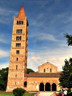
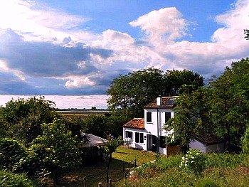
During the Middle Ages, the Po Delta at Massenzatica reached and then took over the position currently occupied by the town of Mesola: a great littoral dune-bar was formed, which – after that – became the seat of the Via Romea and of the important settlement of Pomposa (whose important Abbey is pictured below), linking up the delta of Massenzatica to the one in Volano.
Around 1100AC a series of new ‘rotte’ (breaches), upstream from Ferrara, redirected the Po in a river bed coinciding with the current one almost until its mouth.
The reintroduction of agriculture, favoured by a mild climate phase during the 10th and 11th century, as well as the economic impulse due to large movements of people – prompted by the Crusades first and then by the birth of the ‘Comuni’ – caused in turn important transformations over the land. The marshy environments and the woodlands were both reduced and partly cleared thanks to a continuous, patient and steady effort initiated by the most important monastic centres, which acted as guide and example (first and foremost, nearby Pomposa).
Between the 13th and 15th century, devastating floods – to which one must add plague and famine – led to a stark collapse in population numbers. The hydraulic management of the land was almost completely abandoned, and the economy became essentially based on plant/fruit gathering and animal grazing/pasturing.
After that, the great technical and scientific achievements of the Renaissance, the powerful demographic impulse and the raised economic standing of the cities in the Po valley plains – within the context of the European economy – are the main engines behind the launch of the Great Reclamation effort prompted by the Este family, rulers of Ferrara: between 1564 and 1580, the draining of the lands comprised between Copparo, Mesola and Pomposa was realized (it is the so-called Grande Bonifica Estense).
However, the slumping of the terrains – accelerated by the reclamation process – the changed political situation, a rise in the precipitations (with the consequence of the breaking up of the embankments), as well as the deviation towards the south of the last section of the Po – the final stretch towards the sea (carried out by the Republic of Venice in order to drive away the detritus’ supply from the lagoon): all this caused – already at the beginning of the 17th century – the rapid decline of the ambitious reclamation work started by the Estensi.
During the 19th century the river network had already reached the current geometric layout, but the hydraulic panorama of the land was characterized by many unsolved problems, while the extension of the marshlands and ‘salt valleys’ was still quite noticeable, occupying most of the land.
The removal of water was finally made possible by the introduction of water pumping machines, from 1872 onwards: that is the time when modern reclamation of these lands could officially start – right in the areas where the great design of the Este family had previously failed. Once started, this process would continue with draining the land for more than 100 years, eventually leading to the elimination (in certain cases even excessive) of vast expanses of these eerie sheets of water known as ‘valli’.
Flora and Vegetation
The most important factors concurring to determine the vegetation of a given habitat – in this area – are the type of soil, the distance from the water plate, the climate and the intervention of man. The dunes of Massenzatica – whose summits are found at a greater distance from the water plate – are mainly constituted by thin sands, very permeable; in the so-called infra-dunal depressions, on the contrary, the water plate can be reached already just a few centimeters below the soil, which is further enriched by the accumulation of organic material.
The climate is of an intermediate type between that typical of the Mediterranean zones along the littoral and the much more continental type of the central plains in the interior.
As for the historic vicissitudes of the region, it seems almost certain that the area – surrounded by vast bogs and marshes until the 1800s, was long exploited as pasture land on the dunes’ summits, and also for activities such as the cultivation of poplars, corn and vineyards in the areas among the dunes (‘infra-dunal’), more humid and therefore richer in humus. When walking along the tops and the hollows of the fossil dunes one encounters therefore micro-climatic and economic conditions which are completely different – conditions which are reflected in the typologies of vegetation.
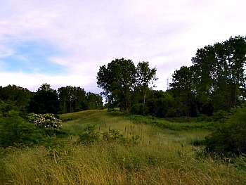
On the tops of the dunes one can find the so-called ‘pioneer plants’, able to withstand aridity and a poor substrate, as well as intense radiation from the sun. This ranges from the more exposed dunes’ summits – where one can see extensive areas with mosses and lichens – to the less steep slopes, where small meadows dominate, which are by far the most characteristic aspect of the Dune di Massenzatica reserve (see image below).
The Seasons of the Meadow
The dominant aspect of these meadows varies greatly with the seasons. In April one can already spot the purple flowers of Common Storksbill (Erodium cicutarium) and the yellow blossoms of Small Medick (Medicago minima). Very common and with small white flowers are also Little Mouse-Ear Chickweed (Cerastium semidecandrum) and Thyme-Leaved Sandwort (Arenaria serpyllifolia).
In May-June the meadow is dominated by the tall spikes of grasses belonging to the Graminaceae family, quite frequent in the arid fields – such as Dasypyrum villosum, Drooping Brome (Bromus tectorum) and Bulbous Meadow-Grass (Poa bulbosa), to which one can add the tiny Sand Cat’s Tail (Phleum arenarium). Present are also various Trefoils (such as Hare’s Foot Clover: Trifolium arvense; Rough Trefoil: T. scabrum and Soft Trefoil: T. striatum); Tufted Vetch (Vicia pseudocracca); the Campion species, like White Campion (Silene alba), the Southern European variant of Small-Flowered Catchfly (S. colorata), Striated Catchfly (S. conica) and Bladder Campion, S. vulgaris (the first species indicated is taller than the others and can be easily identified by the thick hairs growing on the stalk and on the leaves); Maltese Cross (Tribulus terrestris), with yellow five-petaled flowers; the golden-yellow umbels of Cypress Spurge (Euphorbia cyparissias) and Fumana procumbens.
In the summer flower Salad Burnet (Sanguisorba minor), the tiny pink blossoms of Tunic Flower (Petrorhagia saxifraga), Perennial Yellow Woundwort (Stachys recta), the purple-flowered Scaboius Scabiosa argentea, the bright yellow flowers of Common Rock-Rose (Helianthemum nummularium) and Germander (Teucrium polium) – a scented plant with white or light-pink coloured blossoms; finally, Kochia arenaria comes into bloom too – quite a rare species in Italy, which is usually found on the ancient dunes. At dusk open also the bright lemon-yellow blossoms of Evening Primrose (Oenothera biennis) – a herbaceous biennial plant that forms a basal rosette of leaves in the first year of growth, while in the second year it will produce a long stalk (up to 1,5 m high), bearing a flower (in the picture below, the tall grasses sway on the fossil dunes in mid-May).
Scrub and Woodland Formations
With the abandonment of agricultural activities and, more in general, the reduction of the disturbances caused by man – consequent to the institution of the reserve – the presence of woodland cover and of shrubs has decidedly increased. As for the tree and shrub component that one can see today, the peculiar conformation of the terrain in respect to its geographic position (these dunes are in fact now more than 15 km away from the coast) determines very particular conditions. The Mediterranean species that grow on similar types of soil are found only too far away from the sea in respect to their ideal distribution band; on the other hand, the aridity and the poor quality of the substrate does not allow for the settling of continental species, which are common in the surrounding woody thickets (‘macchia’) – except for the depressions among the dunes, where the water plate is more superficial and the soil richer in humus.
It is in these characteristic hollows that one can therefore find tree species typical of the ancient forest (so-called ‘planiziale’), such as Common Elm (Ulmus minor), Oak (Quercus robur) and White Poplar (Populus alba), to which one should add shrubs such as Sloe (Prunus spinosa), Hawthorn (Crataegus monogyna), Spindle (Euonymus europaeus), Elder (Sambucus nigra), Bramble (Rubus ulmifolius) and Crown of Thorns (Paliurus spina-christi). At the margins of the shrubby habitats grow creepers such as Fragrant Virgin's Bower (Clematis flammula) and Prickly Asparagus (Asparagus acutifolius); the most humid part of the understory is punctuated by sporadic violets and scrubs – a formation dominated by European Birthwort, Aristolochia clematis. Noticeable is also the presence of exotic species which have become naturalized, such as Common Locust tree (Robinia pseudoacacia), Honey Locust (Gleditsia triacanthos), Paradise tree (Ailanthus altissima) and Hybrid Poplar (Populus x canadensis). Finally, in the deepest depressions among the dunes have settled dense thickets of a Fern, Pteridium aquilinum.
Adaptations of the Plants of the Dunes to Long Dry Periods
Xerophilous (or ‘xerophile’) adaptations. These can be seen in plants which have adapted to live in conditions of high aridity. The roots are generally very developed in order to reach the underlying deep water plate; the leaves are often transformed into thorns or scales, while the branches become flattened and perform the photosynthetic function: a typical example of this adaptation is Prickly Asparagus. Also the grasses belonging to the Graminaceae family are ‘equipped’ in this way in order to reduce transpiration, with epidermic tissues that are extremely silicified and thick-skinned.
Terophilous adaptations. The so-called ‘therophiles’ are annual plants which overcome the adverse season at the stage of seed. They produce quiescent seeds with a high index of germination, which give rise to sudden and spectacular flowering displays just after the rains in spring or again in late summer. Among the species mentioned above, Tufted Vetch, Small Medick, Little Mouse-Ear Chickweed and the Trefoils – just to mention a few – belong to this category.
Emicryptophiles. These are perennial or biennial herbaceous plants whose renovation gems are found at soil level, in tufts or basal rosettes. During the favourable season, the aerial parts grow considerably; these perform the important task of reproduction – a typical example is Evening Primrose.
Mosses and Lichens. Also the mosses and lichens that colonise the tops of the mounds (the former sand dunes) will present particular adaptations. The low and stretched cushion form of these colonies allows them to reduce resistance to wind and to conserve humidity more efficiently. The moss Tortula ruraliformis, in particular, is a known species for its capacity to tolerate high temperatures and long periods of drought: during the dry season it wraps upon itself, taking on a brownish-red colour; as humidity in the atmosphere increases, it spreads out and becomes green, starting immediately its reproductive phase. Lichens that are found above the moss carpet behave in a similar way, as they can tolerate very long dry periods, putting on hold their metabolic system.
Fauna
The nocturnal habits of the largest mammals present in the reserve (fox, badger, hedgehog and hare) and the small size – and often mimetic – appearance of the other animals make the direct observation of fauna quite difficult. Among the most easily spotted species are Pheasant, Green Lizard (Lacerta viridis), Western Whip-snake (Coluber viridiflavus), Wall Lizard (Podarcis muralis) and – among the invertebrates – butterflies displaying vivid colours, such as certain species of Vanessa and Podalirius machaon, with large yellow and black wings; also, there are several snail species, amongst which is Helix pomatia. The careful observation of the traces left on the ground reveals the presence of a great number of small animals that find within the reserve a precious refuge oasis.
Dens and burrows. The dens of animals such as fox and badger are very similar (often foxes use abandoned badger setts); these are in fact extended subterranean systems with numerous apertures, of about 20 cm in diameter, usually located a few meters apart from one another, and characterized by a great accumulation of detritus in front of the entrance. The little circular grooves among the tall grasses or under a bush, instead, often represent the simple den used by hares to hide away, thanks to the mimetic aspect of their fur.
Auditory signals. As we know, most birds can be identified thanks to their peculiar song. From the wooded thickets within the reserve one can in fact hear the song of different species of birds: from the deep coo of Doves and Woodpigeon (Columba palumbus) to the characteristic call of Cuckoo (Cuculus canorus); from the rich and musical song of Goldfinch (Carduelis carduelis) to the loud fluted whistle of Golden Oriole (Oriolus oriolus). Even in the most humid areas among the infra-dunal depressions a call often rises: it is the croak of common frogs and of European Tree Frog (Hyla arborea), the latter more easily heard after dusk.
Meal remains. The food remains of animals – as well as the droppings – are all valid traces in order to establish their presence within the reserve. Particularly useful are the food remains of Barn Owl (Tyto alba): the undigested regurgitations of this nocturnal bird of prey often contain, in fact, the small bones of Common Vole (Microtus arvalis) and other micro-mammals, thus signaling their roaming the dunes of Massenzatica too.
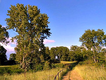
Visit to the Reserve
There is no recommended route for a visit, as the reserve is quite small. There is a small circular route which starts by the small visitor centre (pictured above), easily reached from the nearby towns of Mesola, Codigoro or Comacchio. The trail itself leads into the most representative habitats of the Dune di Massenzatica reserve and can be completed in 1 or 2 hours. It meanders pleasantly among the fossil dunes, allowing close observation of the flora too, with tree, shrub and grass formations which come as a surprise in the middle of such a flat and generally treeless land (see an image of the trail crossing the reserve below). In terms of the times of the year when to visit, spring and autumn are the best, while in summer the temperatures are often stifling, and the area tends to be infested with mosquitoes.
Return from Massenzatica to Po Delta
Return from Massenzatica to Italy-Tours-in-Nature
Copyright © 2013 Italy-Tours-in-Nature

New! Comments
Have your say about what you just read! Leave me a comment in the box below.