- Italy Tours Home
- Italy Ethos
- Tours 2023
- Blog
- Contact Us
- Dolomites
- Top 10 Dolomites
- Veneto
- Dolomites Geology
- Dolomiti Bellunesi
- Cortina
- Cadore
- Belluno
- Cansiglio
- Carso
- Carnia
- Sauris
- Friuli
- Trentino
- Ethnographic Museums
- Monte Baldo
- South Tyrol
- Alta Pusteria
- Dobbiaco
- Emilia-Romagna
- Aosta Valley
- Cinque Terre
- Portofino
- Northern Apennines
- Southern Apennines
- Italian Botanical Gardens
- Padua Botanical Garden
- Orchids of Italy
Monte
Corno/Trudnerhorn in South Tyrol – Where “White Dolomite” and “Dark Volcanic” Rocks Meet.
The Park in Brief
The Nature Park Monte Corno Trudnerhorn is situated in the Bassa Atesina (Lower Adige valley) in South Tyrol, roughly half-way between the two provincial capitals of Bolzano and Trento.
The park was created in 1980 and has a surface of about 6,866 ha. Its core is constituted by a mountain chain which is clearly delimited, to the west, by the Adige valley in the section from Egna/Neumarkt to Salorno/Salurn, by the Valle di Cembra (Cembra valley) in the south west, and by the final section of the Fiemme valley to the north.
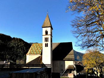
The park is subdivided among the municipalities of Anterivo/Altrei, Egna/Neumarkt, Montagna/Montan, Salorno/Salurn and Trodena/Truden. In this latter village (pictured above) – which gives the mountain (and the park) its German name – is also located an interesting Visitor Centre.
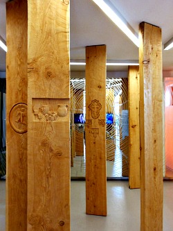
This is hosted in an environmentally friendly building, and its main feature is an ancient watermill dating back to 1948 and still in perfect conditions. Painstakingly rebuilt within the building on its three working levels, it is unique in the region (see a picture of the interior below). Besides a collection of reptiles inside the building, outside the visitor centre is also a small herb garden and a pond.
A curiosity is that the name Trodena/Truden seems to be deriving from the root trodo/troi, which in the old Ladin language means path – in all likelihood a reference to the difficulty in reaching this location from the valley floor. In the main village square there is also a majestic 600-year-old lime tree.
The ‘Wood’s Park’
The ridge that marks the separation between porphyry and Dolomite runs inside the park, and it is extended from the limit of the plains of the Adige valley up until the sub-alpine area around Monte Corno Trudnerhorn (1,781 m) itself. A great variety of wooded habitats cover around 90% of this ‘Wood’s park’ – as it is often called.
In the Monte Corno Trudnerhorn Natural Park we find all the woodland associations typical of South Tyrol, from Sub-Mediterranean woods to larch-pine mixed associations. While the diversity in shapes and colours is immediately apparent, it is more difficult to glimpse the variety and richness of individual species.
The Nature Park Monte Corno Trudnerhorn is not characterized – as other Dolomitic areas are – by the presence of steep needles and pinnacles, but it is notable for its biodiversity in general, both in terms of animals and vegetation; in fact, of all the Natural Parks of South Tyrol, this is the one with the most varied flora and fauna.
Winter starts later here – and it finishes earlier – compared to other areas of South Tyrol: this is the reason why one can see something in blossom at almost all times of the year. The most beautiful sights are without a doubt the meadows with larch – particularly rich in flowers – and the pastures on the highest ridges, while true ecological gems are the numerous peat-bogs and wetlands.
‘Submerged Time’ and ‘Visible Time’: Geology and Hydrology
The territory around Monte Corno Trudnerhorn is articulated into two zones which are geo-morphologically distinct: the left side of the Adige valley – constituted by Dolomite and limestone – and the central-eastern sector, where on the contrary the volcanic rocks of the Adige valley dominate (Bolzano Quartz and porphyry).
About 290 million years ago, fluid lava erupted from the fractured terrestrial crust, while following explosive events volcanic breccias (sedimentary rocks originated by detritus, and immersed in a small-grained paste), tufa and ashes were projected onto the air.
The material originated by effusive lava flows, which was deposited following the explosions, was then solidified giving origin to Quartz Porphyry, with a covered surface of about 6,000 square metres: this represents the biggest volcanic formation in the whole of the Alps.
The rocks created by this event are generally of a red-brown colour, and are composed mainly of a mixture of feldspar, quartz and mica. Because of their resistance and the easiness with which they can be cut, these are very appreciated as material for paving and the production of slabs.
In the areas of Cislon, Prato del Re, Madrutta and Geier one will find the succession of layers typical of the Dolomites; on the contrary, Val Gardena Sandstone is laid on porphyry: the former is a type of rock which is the erosive product of porphyry quartz – generated in a desertic climate – and of the Brixen quartz-Phyllite that surfaces in the gorge of Rio Trodena, near Egna/Neumarkt.
In this area, fossils and charbonized remnants of plants that are referred to in paleo-botany as ‘flora from Egna’ were discovered: these are fragments of stalks and leaves of primeval conifers, and of ferns and palms that were taken by the currents into lagoon bends and then submerged by muddy sediments.
In the low lagoons of the Thetys sea, which was progressively forming, the layers of the Bellerophon and Werfen Formations were deposited, thus accumulating hundreds of metres of layers of limestone, marl, clays and sandstone.
The Contin and Sciliar Dolomite formations stretch out towards the massifs of Cislon and Geier, while the summits of Prato del Re andMadrutta are composed of Main Dolomite.
In the middle of all this, the clayey deposits of the Raibl Formation are inserted, under whose protective blanket are often conserved uninterrupted rock layers – as for instance those that can be found in the Valle delle Anguille (the ‘Eel valley’ gorge) and along the ‘Banklsteig’trail. The existence of several springs testifies to the importance of Raibl layers as a type of rock where water can gush forth more easily.
The ‘Two Horns’, White and Black
To determine the double geologic conformation of the natural park is the so-called ‘Trodena line’, separating the White Dolomite and limestone to the east from the dark volcanic rocks (quartz and porphyry) in the central-western sector.
To epitomise this fact, nothing shows it better than the two horns – two close mountain peaks either side of the ‘Trodena line’: the Corno Bianco/Weisshorn (2,316 m) – white as its name suggests – is calcareous in nature and lies to the east of the fault-line, while the darker Corno Nero/Schwarzhorn (2,439 m) is made of volcanic rocks and is found to the west of the same line.
Vulcanites of the Adige valley (mainly made of porphyry) are ancient rocks, and were lifted more than 2,000 metres following the formation and folding of the Alps – therefore here they are found above the Dolomite layers.
During the Ice Age the glaciers molded the porphyry plateaus; then, with the progressive melting of the ice, pressure on the mountain flanks – as well as on the edge of rocks – also diminished; that is how deep fractures were created, whose consequence was that numerous landslides precipitated towards the valley floors. The more extensive detritic layers are to be found from the base of the Madrutta wall up until the Laghetti area.
As with the geologic formation of the natural park, hydrology is also characterized by partly contrasting aspects: porphyry plateaus are covered with impermeable layers of moraine detritus, and crossed by numerous water courses presenting a richness of wetlands and several other marshy areas.
In the areas characterized by the presence of limestone and Dolomite instead, karstic erosion gave origin to a dense network of cracks and small fault-lines, so that water can percolate and flow – mostly underground. In the smaller streams, there is water only in certain periods, and often arid gorges are all that remains to witness the presence of now disappeared ghost water courses.
Habitats, Animals and Plants
Woodland certainly dominates in the Monte Corno Trudnerhorn Nature Park with a rich flora and fauna, a dense undergrowth, and several tree species.
Altitude, climate, water, type of soil and the quantity of sun and of humidity in the ground are all decisive factors for the presence and location of plants; to these, the influx of man has to be added too.
In the Monte Corno Trudnerhorn Nature park one will encounter a wide variety of natural habitats: from spruce-dominated subalpine woodland (at about 1,700 metres) to the warmer Sub-Mediterranean woodland that comes down to about 600 metres.
Corresponding to its geologic conformation, the park habitats also present two faces: on calcareous terrain we find mainly arid meadows, broadleaved woodland, Scotch pine and other mixed woodland.
Porphyry ridges – given a better availability of water – are covered by lush conifer woodland instead, and one can also find numerous wetlands and peat-bogs.
Given the abundance of trees, dead wood also favours the creation of energy for bacteria, fungi, algae, mosses and insects, thus enriching further the biodiversity of the park.
Man and Nature
Man has left a mark in various ways in Nature Park Monte Corno Trudnerhorn. To begin with, in order to increase the surface dedicated to pastures or to scythed meadows, man has hoed extensive areas which were previously wooded.
He often left the larches, though, as in this way he could make use of the soil in two different ways: either as meadow/pasture, or as a precious source of timber. This is how the first meadows with larch were created: a very beautiful sight from the viewpoint of the landscape, but also extremely interesting when it gets to ecology.
Still today the park is frequented by sap collectors, who make a hole on larch trunks in spring, horizontally with a drill – at about 20 cm of height above the ground – and then close the hole with a stopper.
'True' collection, though, happens only once or twice in a year: on that occasion, a long stick with a groove is inserted into the trunk, and is then extracted with a rotational motion. The sap is taken off the stick and collected in a bucket; the hole is then closed again with the stopper.
Once sap was used to produce ointments and soaking substances for shoes; today it is still employed in the production of plasters, to soften lacquer and to produce natural colours. It is also used to make glue and in the production of essential oils for the body and bath, as well as a natural flavouring for spirits.
In terms of the different landscapes within the park, even those natural-looking habitats rich in hedges – such as the Rentch meadows near Trodena/Truden – are in fact a man-made creation, as for centuries hedges have been playing an important function as natural boundaries for fields, meadows and pastures. They protect from wind and erosion, structure the landscape and are important refuge oasis, used by many animals (especially birds) for reproduction and food.
On a final note, one could say that while always paying attention to its characteristics and thus maintaining an ecological balance, man has used this territory for centuries; therefore, it is quite amazing that we can still get the chance to observe and enjoy unique landscapes – relatively remote, unspoilt, and free from mass tourism – despite being relatively close to cities and important railways and motorways (at least in the area closest to the Adige valley, which has been the more densely inhabited and heavily exploited by human activities over the centuries).
Monte Corno Trudnerhorn is Very Close to the Bletterbach GeoPark
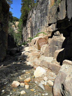
It is also worth mentioning that in the vicinity of Monte Corno Trudnerhorn Nature Park – although strictly speaking out of its boundaries – is the Bletterbach Geological Park and the trails tied to the presence of one of the nine serial zones that form the Dolomites UNESCO World Heritage Site.
This area can be accessed more directly from the village of Aldino/Aldein, but it can be reached with a longer path also from the hamlet of Redagno/Radein, where the Geological Museum is situated, documenting what life was like on planet Earth between 286 and 210 million years ago.
The Bletterbach canyon (see image below) is very interesting from a geological point of view, as it gives a chance to study the creation of the Dolomites as if in an open book, covering the geological time from the Permian to the Triassic; several traces of reptiles and fossils will also be seen along the way.
Anterivo and its Coffee
On the “Anterivo Coffee” – obtained out of a variety of blue-flowered sweet lupin typical of South Tyrol – many interesting stories are being told.
For decades, this plant has been used in order to obtain a beverage similar to coffee, which was drunk by blending it with barley or even with wheat grain, and that was being sold mainly to the local farmers.
Truth to be told, the plant of the “Anterivo Coffee” has no beans as such, and in fact it has nothing to do with coffee at all. It is, rather, a variety of lupin known in botany as Lupinus pilosus, which is known in German as behaarte Lupine (literally, ‘hairy lupin’). This drink is also known in the local German patois as “Voltruirer Kaffee”.
With the progressive spread of ‘real’ coffee, since the beginning of the 1960s the “Anterivo Coffee” had almost totally been forgotten – that is, up to now!
Anterivo/Altrei
Anterivo (Altrei in the German translation) is a small mountain village situated at about 1,200 metres of altitude at the borders between the provinces of Trento and Bolzano, in the high Cembra valley. Only about 400 people live there.
As far back as in year 1897 it was already said that “despite the scarcity of land and humus that characterizes this area (where the dominant rock type is porphyry), here grow all types of cereals and potatoes, as well as the renowned ‘cavolo cappuccio’ (Savoy cabbage); here is cultivated also a variety of blue-flowered lupin, known in the area as ‘Anterivo coffee’, which allows even the poorest people to make a small profit”.
This is why it is so important today to go back and support these early forms of mountain agriculture that are helping to recreate the traditional landscape, where small patches of different colours used to dot the fields, signaling the dominant species and adding variety to the human as well as to the natural landscape.
The Anterivo Lupin
The “Anterivo Coffee” is obtained from an annual plant that can reach 120 cm in height. It has an erected stem with strong ramifications to the sides; its leaves – as the name suggests – are silky and hairy. The beautiful flowers are held in panicles on the top of stems about 5-15 cm long; their corolla is of a bright blue, with yellowish-white – sometimes pink – small dots.
Lupins belong to the family of the Leguminosae (Pea family), and this plant is therefore akin in appearance to peas and beans. Lupins also have a sturdy root with an excellent power to penetrate the soil. They prefer therefore sandy and well-drained soils, with a low pH value.
The typical rock in the area of Anterivo/Altrei is porphyry, covered by a sandy and slightly acid layer – a type of soil which guarantees the ideal growing conditions for the cultivation of lupins.
The project “Anterivo and its Coffee” was promoted by a local group within a provincial initiative that also sees the collaboration of the local inhabitants, and which is finalized to the re-evaluation of this rare autochthonous plant. The initiative has also seen the collaboration of local schools, which have helped in the realization of different phases of the project, together with numerous experts.
Well past the pilot phase, the group is now busy in the development and launch of a new product: the “Anterivo Coffee”. Besides, thanks to the collaboration with the local authorities, this project may now open up interesting perspectives for the development and the valuing of Anterivo.
As a matter of fact, even at this relative early stage, the re-appearance of fields covered in blue-flowered lupins all around the village is already a fest for the eyes, if nothing else – and if you happen to be in Anterivo, don’t forget to ask for a cup of local coffee: you’ll be amazed!
Return from Monte Corno Trudnerhorn to Dolomites
Return from Monte Corno Trudnerhorn to Italy-Tours-in-Nature
Copyright © 2012 Italy-Tours-in-Nature

New! Comments
Have your say about what you just read! Leave me a comment in the box below.