- Italy Tours Home
- Italy Ethos
- Tours 2023
- Blog
- Contact Us
- Dolomites
- Top 10 Dolomites
- Veneto
- Dolomites Geology
- Dolomiti Bellunesi
- Cortina
- Cadore
- Belluno
- Cansiglio
- Carso
- Carnia
- Sauris
- Friuli
- Trentino
- Ethnographic Museums
- Monte Baldo
- South Tyrol
- Alta Pusteria
- Dobbiaco
- Emilia-Romagna
- Aosta Valley
- Cinque Terre
- Portofino
- Northern Apennines
- Southern Apennines
- Italian Botanical Gardens
- Padua Botanical Garden
- Orchids of Italy
The Vena del Gesso, the
Longest Chalk ‘Vein’ in Europe, Rises at the Heart of the Romagna Apennines.
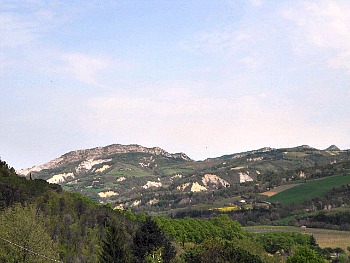
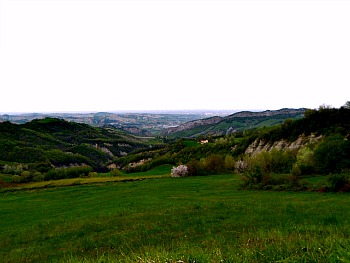
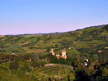
The Vena del Gesso (Gypsum Ridge or Chalk Vein; pictured in the first image above) is situated between the valleys of Santerno, Senio, Sintria and Lamone, which score longitudinally the the hills of the Apennines in the western part of Romagna at about 10 km from the dividing line with the plains to the north. The Vena del Gesso is a mountain outcrop composed mainly of calcium sulphate, variously crystallized and stratified in massive banks, which surfaces for a length of about 20 km and with a width of about 1 km (but it is often thinner), straddling the territories of the two provinces of Bologna and Ravenna.
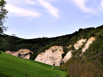
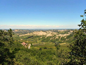
A trip to the section of the Northern Apennines between Faenza and Imola – in the territories of Brisighella, Riolo Terme and Casola Valsenio – reveals to the visitor a landscape of peaceful and somewhat subdued beauty; soft, green hills alternate with wild ‘calanchi’, inhospitable crags, gorges, canyons and cliffs (in the second picture above, the typical sandy-marly stratifications that dominate the landscape of these valleys).
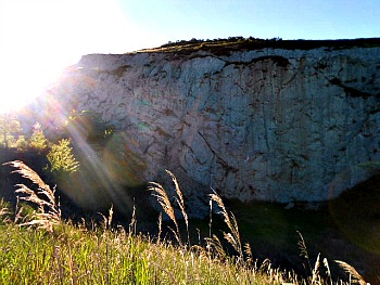
The Vena del Gesso is marked by a spectacular blue-green ridge, which gives a unique appearance to the landscape. With its development of about 25 km, it is the largest chalk outcrop in Europe: a natural and historical treasure which surprises and fascinates walkers on the Parks’ paths. The most moving excursion is certainly along the ridge of the vein, the neares to the chalk strata: on one side, the profile of the Northern Apennines; on the other, the plain stretching out to the distant line of the sea. The area is also full of peculiar karst morphology, with sunken areas, dead-end valleys and numerous caves – in particular the abysses: vertical cavities which go down to record depths.
During the summer, the scent of lavender accompanies the traveler along the country lanes among purple fields – to reach eventually the beautiful “Giardino delle Erbe” (Herb Garden; more on this below).
“Air, water, wines, oil, fruits: so good and tasty than have nothing to envy to any other region” – with these words was this area described in 1594 by Andrea Calegari, Bishop of Bertinoro, to a doctor of the Granduchy of Tuscany. If one visits the castle in Riolo Terme, along the round walk one can get a glimpse of the different environments just described: the ‘calanchi’ (typical erosion forms on clayey soils), the mounts of Rontana and Monte Mauro (the highest elevation in the area) and the Torre del Marino – a tower used for sightings, signaling and defense, dating to the end of the 15th century.
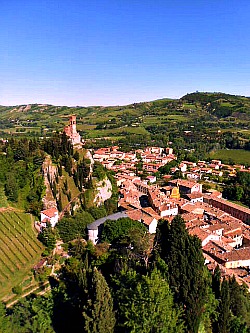
Even more impressing is the sight of the characteristic twin sandstone and chalk peaks of Brisighella, which host the Rocca (castle) and the civic tower respectively (see below a picture of the tower peak and the town lying at its foot).
The Regional Park of the Vena del Gesso Romagnola
In February 2005 the Regional Park of the Vena del Gesso Romagnola (literally the Gypsum Ridge) was created, and today this institution protects one of the most notable natural areas of the section of the Northern Apennines befalling into Emilia-Romagna. Straddling the territory of two provinces – Bologna and Ravenna – the park covers a length of about 20 km, and it is like a thin strip never more than 1,5 km wide.
Crossed by four rivers – Santerno, Senio, Sintria and Lamone – the territory of the new protected area presents itself with a landscape which is very different depending on the aspect: the southern side – mainly occupied by a steep and continuous rock face – has a sparse vegetation of a Mediterranean type that contrasts sharply with the slopes exposed to the north, which have a lot softer outlook and are therefore more wooded, and rich in fresh-humid habitats that host several mountain species normally found only at higher altitudes.
The Vena del Gesso Romagnola stands out with its jagged and wild profile: these are ‘crystal hills’ made of chalk – that is, calcium sulphate – deposited in crystalline form following the evaporation of ancient lagoons. When more than 5 million years ago the strait of Gibraltar was closed by movements of the tectonic plaques, all the water of the Mediterranean – deprived of supply from the Atlantic – evaporated, and therefore chalk, marl and salt layers were deposited, then pushed to the surface.
This phenomenon was common to the whole Apennines’ chain, from Piedmont to Sicily, but it is only here that the Vena del Gesso emerged so neatly and clearly from the subsoil, thus becoming the biggest chalk ridge in Europe – even though it is quite low in altitude.
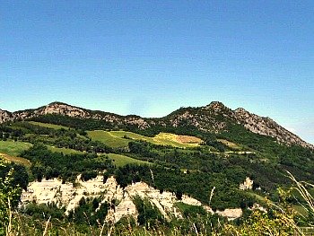
The maximum elevation of the Vena del Gesso Romagnola is Monte Mauro, barely 515 metres above sea level at its highest point. The name of this mountain derives from the ancient Mons Maior (‘Mount Major’), which was later corrupted – during the 19th century – into the Italian version passing through the local form, Mont Maòr. Its steep chalky slopes are the ideal environment as nesting site for one of Europe’s largest night birds of prey, the Tawny Owl or Brown Owl (Strix aluco). Currently, the summit of Monte Mauro hosts the ruins of an old castle and the Pieve of Santa Maria in Tiberiaci, recently restored, which was the seat of an important ecclesiastical-military settlement from the 10th century onwards (a closer look on the mountain is presented in the image below: a view taken from the Lavender route – which is described below – near the hamlet of Zattaglia).
Being chalk a soluble rock when in contact with water (technically speaking, it is a salt), the whole area is characterized by the widespread presence of karstic phenomena – both at surface (‘blind valleys’, dolines, gorges, canyons) and at deep level (sink-holes, springs, abysses and caves).
The peculiar geographic location and the articulation of geologic shapes give life to a flora which is really unique. Emblem of the Vena del Gesso Romagnola is the rare Cheilanthes persica – a small fern originally from the Middle East that grows on rocky outcrops, and that finds here its only Italian station.
The fauna is varied too, with endemic amphibians, rare Mediterranean reptiles, majestic birds of prey and big mammals. Of particular importance are the bats: thanks to the presence of many subterranean habitats, there are in fact 13 species of them here.
In this respect, there are more than one hundred caves in the park, which open up along the main chalk ridge – the most known of them being the Tanaccia, in the Brisighella chalks, and the so-called “Tana del Re Tiberio” (literally, ‘King Tiberius’ Den’), the latter one found on a rocky outcrop that dominates the Senio valley at Borgo Rivola. The Tanaccia is composed of various ‘rooms’, the most famous of which is the ‘guano room’ that takes its name precisely from the huge quantity of deposits left by the numerous colonies of bats that use the cavity as their home (the long sequence of the Vena del Gesso is pictured below, seen from the south; it is possible to distinguish the point where the Santerno passes through – more or less at the centre of the image).
The Carné Geologic Natural Park
The Carné Geologic Natural Park is situated in the area of Rontana and Castelnuovo chalks, and it is rich in fauna and secular trees; it also presents several karstic caves, amongst which are the Fantini, Garibaldi, Carné and Faenza abysses.
The Vena del Gesso formation, for its imposing outlook and composition – as well as for the typicity of its flora and fauna – has decidedly played a big part in the construction of the landscape that one can admire all around, influencing also the history and life of men. It is a natural and historical asset, which will surprise and fascinate the visitor and the walker alike, as they tread along the many paths and trails of the park.
Starting with those that cross the chalk ridge, from here one can immediately detect the lushness and shade of the northern side, as opposed to the luminous aridity of the rock banks with a southerly aspect, where the so-called selenite (‘moon rock’) makes itself visible. Keeping on the trails that meander on the ridge, these will offer interesting insights on the chalk crystallization process at each turn of the way.
In fact, the most interesting excursion is precisely along the main ridge: on one side, there is the blue-green outline of hills that fade to the distant horizon; on the other – beyond the low line of the calanchi (typical erosion forms that characterise the clayey soils of the Apennines; pictured below), which draw a pattern like an arid cobweb on the hillsides – open up the vast plains of the Po valley to the north, populated with towns and cities: a sight limited only – on the clearest days – by the azure line of the Adriatic sea.
Some Other Features of the Area
The Mariano Farm
The Mariano Farm (Agriturismo) is located in a pleasant position, upstream the Gypsum Vein (Vena del Gesso), on a hillock overlooking the Senio valley, close to the confluence with the stream Rio Rivulet. The building is a beautiful tower-house dating to the Middle Ages, made of sandstone rocks originating in the 16th C; inside the tower there are evocative bedrooms. Here starts the path that leads up to the monumental San Biagio ridge, connected to other hiking tracks within the park. The Mariano Farm offers the possibility to stay in a 16th C building, recently refurbished. There are interesting features, such as a wall fashioned in a herringbone pattern, and four ice-houses; the Farm buildings display a characteristic country style. (Open all year round; website: www.agriturismomariano.it).
The Karst System of Monte del Casino and Rio Gambellaro
The Karst system, here, counts seven caves, whose waters are connected. It starts by the fault where Col di Ca’ Budrio is, between the Sasso Letroso and Monte del Casino, where many sinkholes can be found. Sinkholes are large Karst formations; funnel-shaped dips formed by rock solution in rainwater. At the bottom there is a hole where rainwater falling over the sink goes down into a sub-vertical waterway (sinkhole). The Lusa abyss is the deepest of this system, and it is connected to the underlying sinkhole west of Ca’ Siepe, linked with the abyss of Ca’ Siepe itself and with that of Ca’ Calvana, in a complex which is more than 4 km long: all those waters — together with the ones of the nearby caves of Ca’ Budrio — reach the Gambellaro stream. The resurgence cave of the Gambellaro stream is some hundred meters underneath, on the north face of the Gypsum Vein; it has been explored for 335 meters, up to an unaccessible syphon. Inside the cave flows a suggestive perennial stream.
The Lucina Limestones in the Sintria valley
Between the end of the Tortonian and the early Messinian (8 to 6 million years ago), the depth of an ancient sea gradually decreased. At the bottom of that oxygen-poor warm sea were deposited beds of dark clay, rich in organic substance, called “euxinic pelites”, laid before the beginning of the deposition of the Gypsum Vein. They come in lighter layers alternated with almost black ones; the clear layers (deposited under more oxygenated conditions) are rich in fossils, small clams and sea urchins; the black layers (deposited in anoxic bottoms) are rich in organic deposits formed by the remains of animals living in the upper layers of the sea, including those of fossil fish (especially lanternfish, Myctophidae). Accidentally, within the same strata, it is possible to find volcanic biotite-rich horizons, formed by black minerals rich in iron, and disposed in hexagonal thin foils. The biotite was contained in the volcanic ash falling into the sea, as a result of eruptions that took place in the Tuscan archipelago.
The Thematic Routes
The hilly and mountainous area situated between the territories of Brisighella, Riolo Terme and Casola Valsenio offers some thematic routes that can be covered either on foot, on horse or with a mountain bike, in order to discover atmospheric landscapes rich in flora and fauna, peppered with historical settlements and interesting architectures too – not to mention the wine and food (as always, these play such a pivotal role in Italy: they are really part of the local heritage – and even more so in a region like Romagna!).
Among the many treasures of this territory we will find one of particular charm: the “Lavender Route”, which runs its long course between the Sintria valley (from Zattaglia) to Casola Valsenio in the Senio valley, then continues on to Fontanelice in the Santerno valley. This route meanders among the green of trees and the purple of lavender fields bathed in scents, and is at its best from June to August, when it offers the visitor charming sights on the hillsides dotted with castles, towers, ancient churches, monasteries and old hamlets – and lavender is in bloom.
The “Route of Forgotten Fruits” also crosses the ridge between the Senio and Santerno rivers, from Passo del Corso to the dismantled castle on Monte Battaglia. It is a panoramic route along which are to be found eight natural oasis that host about 50 species of fruits that are now considered ‘forgotten’, such as Jujube (giuggiolo in Italian – a small drupe resembling an olive that takes its name from the Latin name of the plant, Ziziphus jujuba), Medlar, the azzeruolo (from Crategus azarolus – a small apple, sort of a cross between a proper apple and a hawthorn berry), various Sorbus species (S. aucuparia: Rowan; S. domestica: Service tree; S. torminalis: Wild Service tree), as well as ancient varities of apple, pear and soft fruits. All of these species were once normally cultivated in the surrounding fields or by the farmsteads, and had a traditional – or sometimes even commercial – use, but were later pushed away by the homogenization of crops. Now – luckily and thanks to initiatives such as this – they are making a less of a timid comeback.
For those wishing to travel differently, worth mentioning is also the old railway that connects Faenza to Florence, which was inaugurated in 1893 and – despite being a secondary line – is still saluted as a real feat of railroad engineering, along which historical carriages are sometimes run.
Brisighella: A Town Built on Chalk
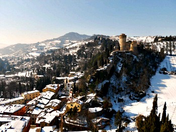
The charming town of Brisighella is perhaps the most interesting built location to visit within the park. It is laid at the foot of three chalk peaks, which host the Rocca (castle; pictured above in a winter image), the civic tower and the Santuario di Monticino respectively. Near the latter is also an interesting Geologic open-air museum, which is one of the highlights of the Park. This has been set up in a former quarry site that has allowed to turn the area into a real open-air book, which allows to study the complex history and all the variations connected with the deposition of chalk, as well as the geologic history of the area at large (an image from the Monticino open-air museum is shown below).
From this location, an interesting sight opens up on the town of Brisighella. This is also a karstic area, and so the Acqua Fredda stream – that goes underground near here – then resurfaces just at the entrance of town, and as such has always been used as a source of drinkable water. The geographic setting also becomes clearer from this ancient quarry site, as the two more central peaks at the foot of which Brisighella is built (the castle and the civic tower – see image below) stand out clearly in the middle of the valley.
The Augusto Rinaldi Ceroni Herb Garden
Named after its founder, the Augusto Rinaldi Ceroni Herb Garden (Giardino delle Erbe; one image is shown below) is a botanical institution dedicated to the conservation and growing of plants of special medicinal and aromatic interest. Owned by the Region Emilia-Romagna, the Herb Garden is managed by the municipality of Casola Valsenio, where it is located, in association with the Comunità Montana Valle del Senio.
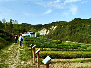
The Herb Garden, included in the Museum system of the Province of Ravenna and in a network of Teaching Farms, includes approx. 450 species of wild medicinal plants used in cuisine, medicine and cosmetics since the late Medieval period, when they were cultivated in the herb gardens of convents and monasteries. The garden constitutes a centre of knowledge and valorisation as regards the cultivation and use of medicinal plants, thanks to activities and goals that range from research to divulgation and from experimentation to teaching, involving both experts and visitors of all ages.
The garden can be visited free of charge during daytime hours in every period of the year, with visitors observing the rules of conduct dictated by common sense and by respect for the structures and cultivations. Visitors are therefore required to follow the paths outside the cultivated plots, and must not pick or damage the plants. To gain a greater understanding of the plants and flowers in the garden through touch and smell, there is a specific route called the “Gallery of Bouquets”.
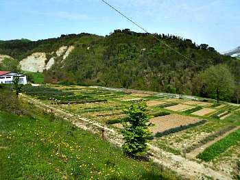
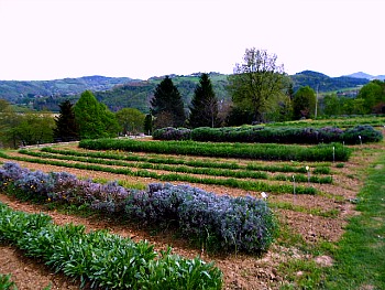
On working days and when other events are held, it is also possible to visit the “Chamber of Marvels” and purchase medicinal plants, “forgotten fruits”, and other products derived from the garden's herbs, on display in the emporium (an aerial view of the garden below shows how the herbs are grown an orderly fashion on elongated plots; the service building is to the extreme left).
Professor Augusto Rinaldi Ceroni was an educator and pioneer on the subject of Italian herbs, as well as creator and animator of many tourist and cultural initiatives that have added so much to Casola Valsenio’s renown. His work particularly focused on herbs, and it started at the end of the 1930 with the creation of a first kitchen garden composed of medicinal herbs, which was gradually enriched in symbiosis with the Infant and later Junior School, where Ceroni was both teacher and headmaster – so much so that he later came to be known to everyone simply as “The Professor”. His goal in life was the study, divulgation and experimentation on medicinal plants – lavender in particular.
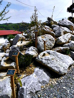
As we have seen previously, the extension of the gypsum (chalk) vein (Vena del Gesso) along an east-west direction means that the two slopes of the ridge enjoy two totally different environments; that facing south is arid and sunny, with a Sub-Mediterranean climate, while the one facing north is green and fresh with a continental climate: hence the presence in these chalky outcrops of a splendidly rich and varied flora and fauna. The environment of the chalk ridge has been recreated also in the Herb Garden, with the allocation of a plot of land called the Selenite Garden – a sort of rock garden where plants that are typical of the ridge are being cultivated (see an image of it below).
Garden Sections and Officinal Plants
The plants in the Herb Garden are arranged in various plots and terraces according to their medicinal properties and uses. They are divided into:
– Officinal Plants. All the species containing active principles useful for the prevention and treatment of human, animal and plant diseases are grouped here, in long rows (see a image below). Among the numerous species grown in the garden are Chamomile, Hawthorn, Digitalis varietes, Henbane, Belladonna, Sage, Valerian, Echinacea, etc. Officinal plants also include aromatic ad cooking herbs, used as spices and in food preparations; among the best known of such herbs are Chive, Salad Burnet, Tarragon, Rhubarb, Lemon Verbena, several Mint and Oregano varietes, Borage, Nettle, Lovage, Calamint and Angelica. These are also known as melliferous plants (prefered by bees), which include also Lavender, Lime, Horehound, Motherwort, Catnip, Sulla, Thyme, Coriander, Sage, Rosemary, Hawthorn and many others. Some plants such as Helichrysum, Honeysuckle, Jasmine, Mint, Absinth, Lavender, Pelargonium, Thyme and Peonies give off highly distinctive leaf or flower scents, which – thanks to their particular fragrances – end up in cosmetic creams and deodorisers too.
– Arboretum. Among the trees and shrubs of medicinal interest are also the plants yielding “forgotten fruits”; i.e. fruits popular in the past and not commonly grown any more today, such as Rowan, Service tree, Medlar, Dogrose, Hawthorn, Buckthorn, Hazelnut.
– Gypsum (chalk) Garden. A special corner has been set up to showcase the main botanical essences found in the Gypsum Ridge Regional Park (Parco Regionale della Vena del Gesso Romagnola; see a few pictures above), which belongs to the network of protected areas of the Region Emilia-Romagna. Other plant groups can be spotted by simply strolling in the Herb Garden: e.g. soil consolidation plants, dyeing plants, poisonous plants, medicinal and floricultural plants.
Return from Vena del Gesso to Emilia-Romagna
Return from Vena del Gesso to Italy-Tours-in-Nature
Copyright © 2013 Italy-Tours-in-Nature

New! Comments
Have your say about what you just read! Leave me a comment in the box below.