- Italy Tours Home
- Italy Ethos
- Tours 2023
- Blog
- Contact Us
- Dolomites
- Top 10 Dolomites
- Veneto
- Dolomites Geology
- Dolomiti Bellunesi
- Cortina
- Cadore
- Belluno
- Cansiglio
- Carso
- Carnia
- Sauris
- Friuli
- Trentino
- Ethnographic Museums
- Monte Baldo
- South Tyrol
- Alta Pusteria
- Dobbiaco
- Emilia-Romagna
- Aosta Valley
- Cinque Terre
- Portofino
- Northern Apennines
- Southern Apennines
- Italian Botanical Gardens
- Padua Botanical Garden
- Orchids of Italy
Ampezzo: a Pleasant Town with Old Architecture, Interesting Museums and Easy Mountain Walks.
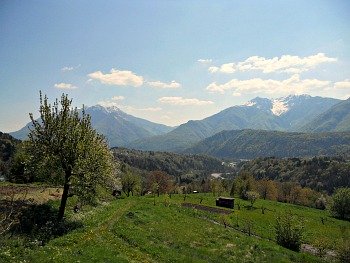
Ampezzo is one of the main centres in the Tagliamento valley. It is a pleasant small town that lies on a natural terrace at the confluence between the Tagliamento and the Lumiei rivers (above, see an image of the open Tagliamento valley in its middle section, where the town is located).
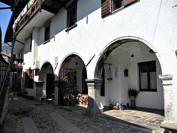
Ampezzo is quite interesting for its vernacular architecture, falling into the “Alto Tagliamento” type; particularly interesting are the old houses to be admired in the two hamlets of Oltris and Voltois – especially those in the latter display a classical medieval structure, and are representative examples of the typical old architecture of Carnia, with arcades and loggias, and the characteristic balconies clad in wood. Oltris, on the whole, is more evocative for its being a medieval village of narrow cobbled streets, but there are also interesting houses, mainly built in stone; the wooden balconies are called “linde” (see above an example of vernacular house in Voltois).
The municipality of Ampezzo is one of the foremost in Carnia for both timber production and animal farming (especially cattle).
Its most captivating historical trait is that during WW2 Ampezzo was the capital for a brief period of the small “Repubblica Libera della Carnia” (“Free Republic of Carnia”), covering an area of the conflict that fell under the control of the Partisan forces (as a note of curiosity, during that time 280 war prisoners from New Zealand were brought here, and contributed to the construction of the dam on the Lumiei, which went on to form the Sauris lake).
Instituted in September 1944, the “Free Republic” did not enjoy an easy – nor long – life (about 15 days), but at the time it was the widest liberated zone in Northern Italy. The glorious episode was then brought to a sudden end by the conjoined repressive action of Fascist and Nazi forces.
As one of the main centres of Carnia, Ampezzo is part of the Carnia Museum Network (“Rete Museale della Carnia”, also known as Carnia Musei), which is evenly spread across the territory; in the central Palazzo Ufner – right in the main square – are now hosted two interesting museums: the Museo Geologico della Carnia (Geological Museum of Carnia) and the Pinacoteca Davanzo: a captivating art collection that displays pictures of local painter Marco Davanzo, who was active during the first half of the 20th century, and was evidently influenced by Symbolism and other important art currents of his time.
The Pinacoteca Davanzo
The artistic production of Marco Davanzo as a painter is strictly connected with everyday and domestic scenes from the Tagliamento valley and the landscapes of Ampezzo; in a nutshell, it encompasses the relationship that links mountainfolk to their land.
It is a type of landscape painting which helps one to become acknowledged with this territory – something also magnificently expressed in Davanzo’s drawings. Very strong and detectable is the influence which was exerted on the painter from Ampezzo by Giovanni Segantini – a famous painter of “life in the mountains” with a strong symbolist vein.
The museum collection is constituted by the Davanzo bequest, which comprises about 1000 works – both finished and drafts – that all share a strong sense of popular culture in the mountains of Carnia. Particularly touching is to see the atelier of the artist, still complete with the instruments and the oil colour tubes used by the painter himself.
As anticipated already, Davanzo was heavily influenced by Segantini, who was an important model for the interpretation of the mountain landscape, centered on an evocative and almost sacred representation of the life of the humble.
Nevertheless, Davanzo would never fully share the divisionist and symbolist approach displayed by the painter from Trento, and his sensitivity would remain closer to the expressionist vein more typical of the Venetian school – the city where Davanzo studied and formed himself as an artist.
His major evolution in style and the achievement of an autonomous and personal language would be reached mainly through landscape painting – in particular with the views of the Carnian Alps, which, at that time, were still largely unexplored from an artistic point of view. The various times of day and the alternating seasons were a source of inexhaustible creativity for Davanzo, and through his brush these mountains became the protagonists of a suggestive pictorial count that the painter would be able to constantly and coherently revisit and enrich over forty years of activity.
After a period spent in the Marche region during the war, Davanzo would go back to his mountains with a renewed palette and a refreshed narrative smoothness. His interest would then be directed more and more towards a personal expression of what this familiar Alpine landscape meant to him. As a mature painter, for Davanzo the Alps of Carnia are confirmed as his natural environment, which he will keep depicting – with faithfulness and enchanted lyricism – until his death.
His original late-19th century approach would not be swayed by the breaking up of form that denotes so much of the art of the 20th century and the avant-garde movements. It is therefore interesting to compare the work of Davanzo with that of another artist, Giovanni Pellis, who ‘fled’ the city and found refuge in the mountain setting of Carnia, away from a world that was rapidly changing. Pellis represented these same landscapes in his drawings and paintings but with a ‘divisionist’ approach (the Italian equivalent of pointillisme), geared at overcoming an overly faithful and naturalistic representation of ‘reality’.
Given their physical proximity, though, cross-fertilization – a sort of hybridization – between the two painters was to some extent unavoidable, and so it happened anyway, bringing about a slow and subtle modernization in the language of Davanzo – but coherent with his character. Nevertheless, he remained quite untouched by the “call to order” and the formal dictates typical of the 1920-30s art – especially during the Fascist period. The artist was getting old by now; he probably felt far removed from the contemporary world, and his character – silent and reserved by nature – became even more introverted.
In spite of his quiet demeanour, Davanzo had tried, with his work, to elevate the status of that century-old relationship that links mountainfolk to their environment through art – a relationship which is not always easy, but that with his personal sharing and the sincere interpretation in his paintings, the artist from Ampezzo managed to portray with outcomes of true, authentic poetry.
Davanzo continued to paint until his death, as painting was for him a creative necessity as well as a deep existential need. His private collection – extremely rich and composed of hundreds of works – is now visible in this Pinacoteca that has been dedicated to him, which documents in an exhaustive manner all the most important stages of his career as an artist.
Davanzo led a simple and secluded life, perhaps, but the intimate, daily relationship cultivated for a whole lifetime with his native land was nonetheless very intense, and his art can still inspire us today to look around these mountain landscapes with a refreshed eye.
The Geological Museum of Carnia
The Museo Geologico della Carnia (Geological Museum of Carnia) has been set up following modern and educational concepts: it collects rocks and – in particular – fossils of great scientific value, as demonstrated by the informative panels that allow the visitor to follow the history of the Carnian territory from 450 million years ago up to 40 million of years ago – that is, from the Silurian Sea to the Devonian reefs, and from the Tropical forests of the Carboniferous to the Triassic Seas, all the way up to Alpine orogeny.
In fact, Carnia is one of the few regions in Europe where the geological and paleontological heritage were both preserved intact; therefore, it records the various stages of evolution that took place in this section of the Alps for a period of approximately 400 million years.
Temporary exhibitions of the most varied geological and paleontological subjects are an addition to the permanent displays, especially during the summer months, adding further interest to the visit. The museum is well-equipped with educational facilities such as laboratories, a “game corner” for the young visitors and a rich, well-supplied scientific library.
The “Sentiero delle Maine” Trail
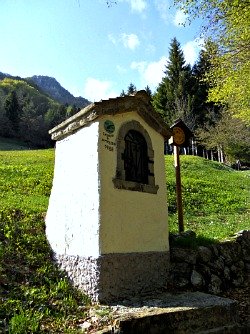
An interesting circular walk has been devised around the town of Ampezzo, and it is probably one of the easiest way to engage and become acknowledged with this territory without venturing in altitude: it is called “Sentiero delle Maine” – the “maine” being the small religious chapels that dot the fields, and that one can also encounter along the streets and paths: traditional manifestations of popular devotion that go back a long way in time (in the image above, one of the many religious capitals that are met along the trail).
In order to start this walk, one has to descend to the bridge by the Lumiei, and then from there ascend to the hamlets of either Oltris or Voltois. It doesn’t really matter in which order the trail is taken, as the route is circular, but in my experience it is better to ascend through Voltois first, as the section after Oltris is quite steep – so it is probably best kept for the descent.
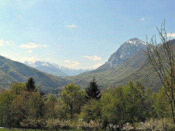
In either case, the highest section of the walk allows for interesting views towards the upper Tagliamento valley (as in the picture below) and the surrounding peaks, while in the right season (spring/early summer) the area is also noteworthy for its flora. This walk is easy, and therefore suitable for all abilities, but there is always the possibility, of course, for more demanding hikes in altitude as well – such as the suggestion that follows.
The 'Tiziana Weiss' Circular Trail in the Forest of Ampezzo
The trail dedicated to Tiziana Weiss – a naturalist and alpinist from Trieste, who tragically died in the course of an Alpinistic excursion – immersed in the natural setting of the Forest of Ampezzo, is not only a first-rate excursion but something more.
This circular trail represents an optimal opportunity in order to starting to get to know the natural environment of the Alps of Carnia. While walking along the trail, one gets the chance to discover aspects of high mountain habitats that a common excursionist would rarely notice and put in correlation.
By stopping from time to time along the way, and carefully observing the natural environment around the path, one can comprehend, for instance, which influence altitude, aspect and the geologic nature of the terrain have on vegetation, or still, which is the origin of the different types of rock that form the massif of Monte Tinisa (2,120 m) – a Dolomitic pyramid dominating the trail all along.
As one proceeds, twelve ‘stations’ have been individuated and evidenced with wooden boards; these – should you wish to – will give you more detailed information on specific themes such as geology, flora, fauna and vegetation (but you would still need to have the dedicated booklet with you – or print this page – before setting out).
The fascination of this trail, though, goes well beyond the detailed descriptions included in the booklet – or indeed here – and even the most hurried walker will not fail to be captivated by the scenery. The thick forests that are being crossed in the first section of the itinerary, the beautiful pastures of Casera Tintina (1,495 m) and the meadows that are found on the summit of Monte Tinisa are landscape elements that will provide the walker with genuine fascination.
The views are no less beautiful than the natural setting: the trail runs in fact for a while along the main ridge between the Tagliamento and Lumiei valleys; on one side, one can see the flat mountain tops of the Pre-Alps and the Dolomite groups of Cridola, Monfalconi and Pramaggiore.
On the other side, on the contrary, the sights dominate over the Sauris basin and one can also notice some of the principal peaks of the Carnian Alps (Alpi Carniche): the Dolomiti Pesarine, Creta Forata, Monti di Volaia and Monte Coglians, which appear to the north beyond the pastures and the mountains above Sauris.
Hereafter the trail is being described, following the order of numeration of the observation ‘stations’. Obviously, it goes without saying that it is also possible to follow the path in a reversed order, or just a part of it.
From Rifugio Tita Piaz (a mountain hut; 1,417 m) one follows the track that first goes to Casera Tintina (1,495 m); this is a forestry road closed to traffic (marked CAI 215) that meanders in a mixed spruce-beech woodland, rising gently at first, then almost flat until the scree (‘canalone’ in Italian) called Ruvis di Tintina. Beyond this ‘cut’ the route crosses, for a short while, some easily eroded chalk layers (pay extra care in this section).
Observation station number 1
Chalks of the Triassic Lagoons and the structure of Monte Tinisa. These chalks were deposited 205 million years ago, in a lagoon environment characterized by a strong evaporation. These rocks – tender and easily erodible – have been playing the role of a ‘tectonic lubricant’ that facilitated, during the course of the formation of Monte Tinisa, the overthrust of calcareous layers.
The route continues along a flat section and crosses the ‘canalone’ of Rio della Calcina; here starts a section of path that will take you to the top of Monte Tinisa, rising through mixed woodland of beech and fir.
Observation station number 2
Mixed woodland of beech and fir. This station has as a main theme the detailed description of a type of habitat known as Abieti-fagetum, characterized by the presence of beech, Silver fir and spruce, and also of a particularly lush undergrowth. Among the species that go to form these shrubby formations are rowan, sycamore and Alpine honeysuckle, while the herbaceous layer includes different types of ferns, plants such as Cardamine trifolia and the grass Luzula nivea. In the clearings one can notice other species such as Petasites, Adenostyles alliariae, Ranunculus aconitifolius, Alpine lettuce (Cicerbita alpina) and Wolfsbane (Aconitum luparia).
At the end of the rise one reaches the edge of pastures of Casera Tintina, dominated to the south by the high calcareous-Dolomitic rock faces of Monte Tinisa.
Observation station number 3
Life and landscape at Casera Tintina. The main theme of this stop is the description of the life once led by the shepherds living in the ‘malghe’ – dairy farms active mainly during the summer months. Interesting is also to recognize the different herbaceous species that form the pastures, amongst which are Crepis aurea, the grasses Festuca nerasta and Poa alpina, field trefoil (Trifolium pratense) and a dandelion species, Taraxacum hispidus. In the areas where manure was accumulated the pasture is invaded by nitrate-loving plants such as Alpine rhubarb (Rhabarbarum alpinus) and Alpine dock (Rumex alpinus) – all species that not just prefer but also enrich the soil in nitrates.
Here is illustrated also the origin of rocks of Monte Tinisa, which were formed around 225 million years ago by deposition of sediments rich in calcium carbonate, in a temperate sea about 50-100 metres deep.
The path in the forest is followed by another section at the southern margin of the pastureland, until one reaches a junction between two paths near a spring. One then follows to the left a path among crawling bushes and trees, stunted also by winter avalanches. One can easily spot a willow species (Salix appendiculata), green alder (Alnus viridis), spruce (Picea abies), larch (Larix decidua), rowan (Sorbus aucuparia) and a type of birch (Betula verrucosa).
After a steep section, the path passes a hump on the ground, which is the mark left by a moraine from the last glaciation (a glacier which receded 6000-8000 years ago), then one starts to rise again among a thicket of Dwarf mountain pine (Pinus mugo).
Observation station number 4
Dwarf mountain pine woodland. This type of Alpine woodland covers – above the level of permanent wood – all the slopes of Monte Tinisa. Dwarf mountain pine loves to cover calcareous sites and, on the slopes with a northerly aspect, it is accompanied by hairy Rhododendron (Rhododendron hirsutum), Lingonberry (Vaccinium vitis-idea) and Dwarf juniper (Juniperus nana).
Thanks to the enormous development of their root system, Dwarf mountain pines play, as a species, an important role as stabilizer of those very slopes which are subject to erosion. Also, the elasticity of their twigs allows them to colonize even those mountainsides which are subject to snow slides.
Once out of the Dwarf mountain pine thickets the path rises with hairpin bends the steep slope and, once under rocky walls, takes to the left along a stair-like scree covered with grass and detritus. From the end of a short exposed ridge – equipped with a metal rope – one is allowed to reach the Forcella Malpasso di Tinisa pass (1,960 m); if desired, from the pass, one can in fact stray off the main trail with a deviation to reach the summit of Monte Tinisa (2,120 m).
Observation station number 5
Flora of the carbonatic rocks. The main theme of this station is the rich flora that covers the rocks beside the pass. Among the more spectacular species one can notice an Alpine cinquefoil with showy pink blossoms (Potentilla nitida) and some saxifrages (Saxifraga crustata and S. caesia), with their coarse leaves that form characteristic rosettes and exude limescale. The Alpine primrose (Primula auricula) and the famous Edelweiss are often visible here too.
The Tiziana Weiss trail then lowers down in a slight diagonal fashion towards the right along a detritus’ slope, then bends more decidedly to the right, at first along a scree with big boulders, and finally across a steep slope (in this section one has to exercise extreme caution).
Observation station number 6
Platform rocks. This is a high pasture with continuous earth clods. The rocks that surface here are Dolomitic in nature, plus the calcareous layers of the so-called ‘Carbonatic Platform’, which derive from the slow chemical transformation of limestone.
The compact and uniform grass cushions that cover the slopes are formed mainly by two coarse grasses: Sesleria varia and Carex sempervirens, which give origin to a plants' association known as ‘Seslerio-Caricetum sempervirentis’. This type of Alpine meadow, spreading from the Pyrenees to the Carpathian mountains across the Alps, represents the main form of nourishment for the chamois.
At the end of this long traverse, one eventually reaches the Forcella del Fieno pass, to the east of Punta dell’Uccel, the 'Bird's Peak' (1,983 m).
Observation station number 7
Stories of ‘fens tant lontans’ (‘Faraway Hay’ in the language of Friuli). Hay (fieno in Italian) represented once the most fundamental resource in the economy of these poor valleys. Even the steepest slopes – the highest in altitude, like those to the south of the forcella – were once regularly scythed. The very toponym of Forcella del Fieno (the ‘Hay pass’) reminds precisely of the work of valley people, who used to come all the way up here in order to scythe these steep meadows, and thus obtain meager fodder for their animals. This was then taken down to the valley bottom, with such hard work that is unimaginable to us today.
The trail continues near the ridge; in this first section this is constituted of calcareous rocks covered in Dwarf mountain pine, while in the next section the soil is formed mainly by rocks of volcanic origin. From this point onwards, it is possible to see – towards the south – a small lake in which Alpine triton thrives (Triturus alpestris).
Observation station number 8
Bushes with Rhododendron and blueberries (in areas exposed to the north) and meager pastures with Nard (the grass Nardus stricta) in locations exposed to the south. This is an ideal situation in which to observe the difference in vegetation between the two sides, according to their aspect. The northern side is covered with Green alder (Alnus viridis) and by a mixed association Rhododendron/blueberry, which both denote the presence of acid soil.
The southern side, on the contrary, is covered by the ‘Nardetum alpigenum’ association, a type of Alpine meadow that also prefers acid soils. In this plants’ association the presence of Nard (Nardus stricta) is dominant: this is a small grass belonging to the Graminaeceae family, which is not very liked by animals, and that tends to become invasive in those pastures that are overused.
The ridge culminates at the summit of Punta dell’Uccel (see above), which is marked by a plaque that allows an easier identification of the surrounding peaks. There are very wide – and spectacular – views form here.
Observation station number 9
Formation of the geologic landscape. This station has as a main theme the description of the morphology and the origin of the mountain chains of the Alpi Carniche. As a rule of thumb, one could say that these mountains are mainly formed by rocks which are more and more ancient as one travels further north.
Looking north, in fact, one can easily individuate the mountains of Sauris, formed mainly of marl and sandstone, which are easily eroded (as witnessed by the rounded shapes of the peaks and the huge landslides that affect the southern slopes); the chain of the Terze, Monte Clap, Creta Forata and Pleros appear next – all constituted by Main Dolomite and other Dolomitic limestone. Finally, the mountains of Volaia and Coglians close the horizon: these are formed mainly of calcareous rock, mostly of crystalline origin, and are among the oldest in the Alpi Carniche (350-400 million years ago).
Observation station number 10
Green volcanic rocks and thickets of Green Alder. The greenish rocks in the ridge section of Punta dell’Uccel di Tinisa (1,983 m) are formed by lapillus and volcanic ashes (tufa sandstone) that were deposited in a shallow sea environment or even on dry land. It is not yet clear where the actual volcanoes, which gave origin to these rocks, were located, but the Alpine thickets of Green alder are strictly connected to the presence of these volcanic rocks. This species prefers in fact acid soils too, and tends to avoid areas formed by carbonatic rocks, over which – on the contrary – thickets of Dwarf mountain pine tend to settle with more ease.
After a well-deserved stop on the summit, the descent towards Forca di Montof finally begins. One follows the ridge, which is flat at first and covered with shrubs dominated by Green alder and larch, where in July the beautiful Yellow-spotted gentian (Gentiana punctata) also blossoms.
The ridge then becomes steeper and more accidentated: after a small rocky outcrop, which can be passed with the aid of an iron rope, one always continues in the vicinity of the main ridge, now full of detritus and dominated by a discontinuous grass cover until Forca di Montof (1,820 m), to the north of which is visible the so-called peak of Uccel di Tinisa, similar in shape to a rocky soldier.
Observation station number 11
Plants which colonize the high Alpine meadows: Carex firma. This station is dedicated to the description of the ‘Cariceton firmae’, an association dominated by the coarse Alpine grass Carex firma. This plants' association constitutes one of the intermediate phases in the colonization of scree slopes on the part of high altitude mountain vegetation.
From the pass, the CAI trail marked 233 descends northbound on the left bank of the small Tintina valley, at first among the tall grasses of an abandoned pasture, then amongst thickets of Green alder; from there, the trail proceeds towards the ridge of Monte Cavallo di Cervia (from the Forca di Montof it is also possible to descend more quickly towards Casera Tintina by following the CAI trail marked 215, which keeps to the right of the small Tintina stream valley). One then follows the wide rounded ridge among sparse and light woodland, with tall specimens of larch and spruce, which give it the aspect of a lush garden.
Observation station number 12
The shallow sea of the Werfen era and the larch. The wide rounded ridge of Monte Cavallo di Cervia (1,704 m) is formed by easily erodible Triassic rocks (220-230 million years ago) that gave origin to deep soils, over which a lush vegetation can thrive. These rocks were formed in an open and shallow sea environment, in the vicinity also of river mouths that transported huge quantities of fine non-carbonatic detritus. Along the ridge – and in all areas of the Forest of Ampezzo, at altitudes above 1,600-1,700 m – beech gives way to larch: the only conifer to shed its leaves.
Once reached an open ridge, the path then descends to the right, with numerous bends until reaching the stony bottom of the Tintina. Once crossed the stream, one rejoins the CAI trail marked 215 and, through a woodland track, one reaches again Casera Tintina, passed by at the beginning of the trail. Then, following backwards the track walked in the first part of the circular route, one will end up again at the starting point, by the Provincial Road in the vicinity of Passo Pura.
Return from Ampezzo to Italy-Tours-in-Nature
Copyright © 2012 Italy-Tours-in-Nature

New! Comments
Have your say about what you just read! Leave me a comment in the box below.