- Italy Tours Home
- Italy Ethos
- Tours 2023
- Blog
- Contact Us
- Dolomites
- Top 10 Dolomites
- Veneto
- Dolomites Geology
- Dolomiti Bellunesi
- Cortina
- Cadore
- Belluno
- Cansiglio
- Carso
- Carnia
- Sauris
- Friuli
- Trentino
- Ethnographic Museums
- Monte Baldo
- South Tyrol
- Alta Pusteria
- Dobbiaco
- Emilia-Romagna
- Aosta Valley
- Cinque Terre
- Portofino
- Northern Apennines
- Southern Apennines
- Italian Botanical Gardens
- Padua Botanical Garden
- Orchids of Italy
The Livenza Springs: Magical Act of Nature in “Technicolour”.
The Livenza Springs (Sorgenti della Livenza in Italian) are a very little known spot of incredible beauty lying just at the base of Cansiglio, in the Pre-Alps of Friuli.
The Livenza is a typically karstic river; its pure, crystalline water seemingly gushing out of nowhere. In fact, this region at the foothill of the Pre-Alps is where the underground water systems that originate in the Cansiglio plateau see the light again after a long journey underground – and they do so with a series of spectacular springs.
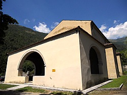
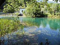
Two of these springs form the river Livenza itself. The first of these springs is called “La Santissima” – ‘the Very Holy’ (see picture below); a name due to the fact that probably the location was already known – and used – as a sacred site devoted to the Water Goddess and to Pagan rituals since time immemorial. As it almost inevitably happens in such cases, the site was later taken over by Christian worship, and a church was erected on the same spot.
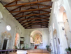
The “Santuario della Santissima” is in fact a beautiful church, erected in a simple and essential Gothic style just beside the Livenza springs. Its building provides an additional note of interest to the visit, as it is a very peaceful place – especially on a hot summer’s day, when you may look for respite from the heat, and the hypnotic noise of the cicadas will follow you even into the quiet and scented semi-obscurity of the church’s interior (see pictures below). If you do walk in, do not miss the 16th century trinity sculpture on the main altar, and make sure to descend into the cool crypt, where there are wooden statues of a popular Pietà, movingly simple.
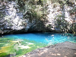
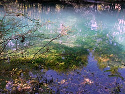
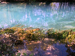
But from the point of view of nature, certainly the Livenza springs are the prime motive of interest here. There is a short circular route going all around their perimeter, and this will allow you to both see the water literally gushing out from under your feet (over the bridge where the path passes), as well as being mesmerized by the incredibly transparent quality of the water, animated by vivid aquatic plants and algae floating with the current like green siren’s hair. Tempting as it may be, though, entering the water – despite being certainly possible – is not for the faint-hearted: this is water from the uplands that sees the light again after a long journey into the Earth’s bowels, and therefore it is as cold as only melted ice could be (below, are images of the Livenza springs at La Santissima).
The quietly running, newly born Livenza river then continues its meandering journey southwards towards the Adriatic sea, but before reaching it, it will pass through the quaint town of Sacile, just a few kilometers downstream, where you may want to go, after visiting the springs, for some sustenance in one of its restaurants or trattoria – or better still, if you happen to be there at the right time of year, you may wish to pay a visit to the locally renowned “Sagra degli Osei” – the so-called “Birds’ Fair”.
But then you would have to plan your visit very carefully, as this event literally happens only just once in a year, normally on the first Sunday following the Ferragosto (a very popular Italian bank holiday that invariably falls on the 15th of August).
Back to our Livenza springs, though, the visit does not finish there; instead, we will follow the line of the foothills for about three kilometers to the east to reach another highlight.
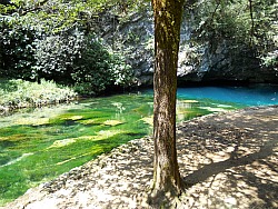
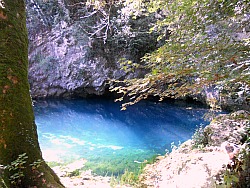
Imagine now an pool of water gushing out of the living rock, of the most incredible turquoise blue you can think of: this is the Gorgazzo Springs – where yet another karstic water system from the Cansiglio plateau sees the light of day after a long, mysterious journey underground.
What you will find here is a pool of amazingly clear water (see pictures below) of the most enticing cobalt blue – almost surreal in its brilliant intensity. Many poets and painters have been captivated by this sight, and have produced verses or paintings inspired by it – and once there, it will not be difficult to understand why.
To this day, the area retains a sacred aura that bears witness to its having been a place of worship for a very long time, and despite the fact that there are no churches or chapels, if you manage to stay in silence for some time (but if you aim for that, do not come during a weekend!), you will definitely sense something in the air.
Whether you believe in (or sense) the sacredness of the place or not, however, this could simply be somewhere to come and have a bit of restful time. Near the Gorgazzo pool there is also a popular – but very discreet – café (although, again, not on a weekend), with nice tables under the shady trees, where you can just come and read a book in a peaceful setting, gently accompanied by the sound of gurgling water – or for a good meal.
Out of the Gorgazzo pool stems out another branch of the
Livenza river, which – a little further – goes through the pretty town of Polcenigo, to finally join up
with the Santissima branch further down, just before Sacile (the main town in the area, mentioned
above). Here you may also find shops and restaurants that sell and cook a local variety of Saffron (Crocus sativus), the Zafferano di Dardago, from the name of a nearby village (head especially to the Taverna del Castello).
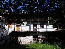
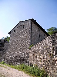
The vernacular architecture is also interesting, and it displays houses built with a local grey stone (probably mostly taken from riverbeds), sometimes clad with long and narrow wooden balconies, in a typical Pre-Alpine style (see images below).
If you are interested in this aspect, there are several hamlets you may wish to visit in the area near the Livenza springs, such as Fiaschetti, Villa d’Aviano (also with three small ancient churches), Giais and Marsure.
If you still have time and energy, near Polcenigo there is yet another feature worth a detour: the Parco Naturale del Colle di San Floriano (San Floriano Nature Park).
This small but nice educational facility is part of the Europarc network, and it can provide an ideal complement to a visit of the springs – especially if you are interested in fruit trees. The area – facing south and sheltered by the steep mountains rising suddenly out of the plain – has a mild microclimate, which makes it particularly good for fruit production: hence the idea of a fruit tree arboretum of scientific value, grown here mainly for research and educational purposes.
The park is surrounded by all the habitats that are typical of the ‘Pedemontana’ region (a term that literally means “at the foot of the mountains”), such as thickets of Pubescent oak (Quercus pubescens) and Hop hornbeam (Ostrya carpinifolia). On the hilltop, the secretive little Roman church of San Floriano (unfortunately closed at most times), flanked by some old olive trees, gives the location (and the park) its name, and marks yet another site of ancient Pagan devotion.
The ‘magredi’
The ‘magredi’ steppes are dry river habitats located in the middle of a V-shaped area to the north-west of Pordenone, designing the dry river beds, of two large rivers, the Meduna and Cellina. As a background, these steppes are bordered by the Mount Cavallo massif (2,100 m), which stands out in the distance. The waters of the two rivers sink into the ground, leaving on the surface wonderfully smooth round pebbles and thus creating one of the most important natural environments in the region, which hosts a most peculiar flora. It is among these stones that, for instance, the Wild cabbage Brassica glabrescens sprouts: it bears delicate yellow flowers and it grows exclusively in this area; it isn't found anywhere else in the world. There are also some endemics, such as Tatarian Kale, Crambe tatarica, another species belonging to the cabbage, reputedly introduced at the times of invasions by populations of eastern provenance. But the ‘magredi’ are interesting also for their fauna – in particular the presence of Stone-curlew (Burhinus grallarius).
The ‘magredi’ steppes – which measure more than 43,000 ha and are comprised within the four municipalities of Cordenons, Maniago, San Quirino and Vivaro – have been included for their uniqueness among the ‘Sites of Community Importance’ (SCI), which are designated and approved by the E.U.
The Prehistoric Site of Palù di Livenza
In 2011 another place in the province of Pordenone gained the attention of the UNESCO: it is the Prehistoric site of Palù di Livenza, also called Palù della Santissima (the ‘Very Holy’), which is named after the marshy area downstream the Livenza springs (described above), at the south-western foothills of Monte Cavallo. The value of the site has been known since the 1960s, when – during excavation works – archaeological finds came to the surface, proving the existence of ancient pile-dwelling settlements. Studies suggest that use of this site dates since the ancient Paleolithic age (about 4900 BC), which would make it the oldest pile-dwelling site in Northern Italy; in particular, further studies have demonstrated the existence of at least three types of pile-dwelling building structures, related to different stages of settlement and chronologically dating back to the late Neolithic period. The Palù di Livenza is connected to a network of archaeological sites present in the Pre-alpine range of Pordenone province, which includes Monte Castelir, San Giovanni di Polcenigo, San Tomè di Dardago (whose nature trail is described later) and Piancavallo. More information on the Palù di Livenza below.
The site of Palù di Livenza is situated in a wide area of resurgent springs (risorgive) connected to the Livenza river, between the hills of Sarone and the ridge of Longone. The flint artifacts which have been collected since the end of the 19th century, the underwater explorations and the archaeological investigations of the last twenty years allow us to consider the Palù one of the most interesting Pre-historic sites in Northern Italy. The Palù was already frequented in the Upper Paleolithic and it represents therefore one of the rarest examples of sites in wetlands in Northern Italy. But it was in subsequent times, between the late Neolithic and Eneolithic (4th and 3rd millenium BC) that the Palù accounted for one of the most important North-eastern Italian pile-dwelling villages, in which at least three complex wooden building systems have been identified. The most ancient technique (ca. 5,700 years ago) consists of an anchoring system made of horizontal oak planks, othogonally placed in order to form a network of regular meshes. Later (ca. 5,200 years ago), horizontal structural elements were used (planks, beams, rafters), while more recent structures, resting on large load-bearing oak poles, are ascribable to 4,800 years ago. The materials recovered during the investigations consist of ceramic and flint artifacts to be related to a stage of the Culture of Square Mouth Vases (Cultura dei Vasi a Bocca Quadrata). It is well-founded to believe that already in the Bronze Age the area had turned into a marsh. The palaeo-botanic documentation recovered gives us information on the environment, feeding habits and agricultural techniques; there have been found cereals, fruits, flaxseeds. Among the fauna, there were deer, wild and domestic pigs, sheep, goats and cattle.
The San Tomè Nature Trail
The short valley of the Cunaz-Artugna stream – along which runs the path in question – is part of the southeastern gradient of the western Prealpi Carniche (Carnian Pre-Alps), comprised between the two small towns of Budoia and Montereale Valcellina. The area is characterized by prevailing calcareous rocks that were formed during the Jurassic-Cretaceous period. At that time, the environment was that of a marine platform – that is, a shallow sea with very little emerged lands, in which a relevant deposition of calcium carbonate was taking place, due also to the notable organic activity: we are in fact on what, during the Jurassic-Cretaceous, was the north-western edge of the Friuli Platform, linked – towards the west – by an escarpment to the Belluno basin, in which were deposited sediments of a deeper sea. Later – in the period that goes from the Miocene to the Pliocene – the area underwent an intense deformational activity, due to the emersion of the Alpine chain, which with its rising determined a large part of the current landscape. At the end of the last glaciation (Wurm – terminated about 12,000 years ago), the rivers caused the deposition of enormous amounts of material, thus determining the formation of the high plains of Friuli (on ‘alluvial fans’, or ‘conoids’).
The actual torrents – with a temporary regime, short course and elevated incline –, present all along the course of the southeastern slope of the western Carnian Pre-Alps, have originated, and still feed, ‘dejection fans’ (or ‘conoids’) of a certain relevance, favoured in this sense also by a relative fragmentation of the rock mass, accentuated by the widespread karstic features. Moreover, this latter phenomenon influences a large part of the hydrographic network of the Cansiglio-Cavallo mountain chain; subsequently, streams and torrents have incised the ‘fans’ (or ‘conoids’), thus originating a series of terraces – such as those visible here, precisely along the course of the Cunaz-Artugna stream.
The landscape that surrounds the trail is the complex expression of the natural and anthropic transformations that followed one another over time: the natural ones – due to climatic changes, soil evolution, the succession of the various plant communities and their natural strive towards the best use of the available resources – and those produced by man, due to the building of artifacts, as well as intentional or involuntary interventions on the tree cover and the vegetation at large.
The San Tomè Nature Trail, in its short route, crosses at least five aspects of vegetation worth taking into account: 1) the area of the mill, with stable meadows and natural hedges as property boundaries; 2) the bed of the Artugna stream; 3) the broadleaved woodland, mostly composed of Hop Hornbeam and Manna Ash, with some Pubescent Oak and Hazel; 4) the rocky section, overhanging the trail; 4) the scree, with the presence of a grass, Festuca spectabilis and of Geranium macrorrhyzum; 5) the reforestation patch, with conifers, by the church of San Tomè. For more detailed information on the San Tomè Nature Trail, please refer to the Budoia page.
Return from Livenza Springs to Cansiglio
Return from Livenza Springs to Italy-Tours-in-Nature
Copyright © 2012 Italy-Tours-in-Nature

New! Comments
Have your say about what you just read! Leave me a comment in the box below.