- Italy Tours Home
- Italy Ethos
- Tours 2023
- Blog
- Contact Us
- Dolomites
- Top 10 Dolomites
- Veneto
- Dolomites Geology
- Dolomiti Bellunesi
- Cortina
- Cadore
- Belluno
- Cansiglio
- Carso
- Carnia
- Sauris
- Friuli
- Trentino
- Ethnographic Museums
- Monte Baldo
- South Tyrol
- Alta Pusteria
- Dobbiaco
- Emilia-Romagna
- Aosta Valley
- Cinque Terre
- Portofino
- Northern Apennines
- Southern Apennines
- Italian Botanical Gardens
- Padua Botanical Garden
- Orchids of Italy
Budoia and the San Tomè Nature Trail: A Taster of Nature of the Carnian Pre-Alps, Western Friuli.
Short General Geological Annotations
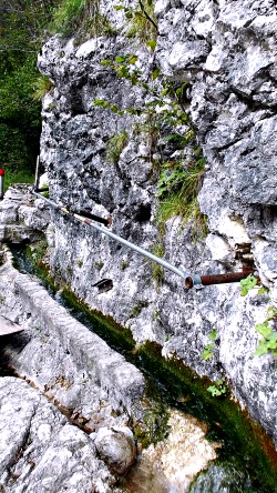
The short valley of the Cunaz-Artugna stream – along which runs the path in question (pictured above in the section between Dardago and the upper valley) – is part of the southeastern gradient of the western Prealpi Carniche (Carnian Pre-Alps), in the stretch comprised between the two small towns of Budoia and Montereale Valcellina. The area is characterized by prevailing calcareous rocks that were formed during the Jurassic-Cretaceous period. At that time the environment was that of a marine platform – that is, a shallow sea with very little in the way of emerged lands, and in which was taking place a relevant deposition of calcium carbonate, due also to the notable organic activity (a current example of that reality today are the Bahamas islands).
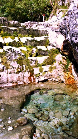
We are in fact on the north-western edge of what, during the Jurassic-Cretaceous period, was the Friuli Platform, linked – towards the west – by an escarpment to the Belluno basin, in which were deposited sediments of a deeper sea. Later – in the period that goes from the Miocene to the Pliocene – the area underwent an intense deformational activity, due to the emerging Alpine chain, which with its rising determined a large part of the current landscape. At the end of the last glaciations (Wurm – terminated about 12,000 years ago) the rivers caused the deposition of enormous amounts of material, thus determining the formation of the high plains of Friuli (on ‘alluvial fans’, or ‘conoids’). The actual torrents with a temporary regime, short course and elevated incline, present all along the course of the southeastern slope of the western Carnian Pre-Alps, have originated – and still feed – ‘dejection fans’ (or ‘conoids’) of a certain relevance, favoured in this sense also by a relative fragmentation of the rock mass and accentuated by the widespread Karst features (such as the erosion pot-holes shown in the image above); moreover, this latter phenomenon influences a large part of the hydrographic network of the Cansiglio-Cavallo mountain chain; subsequently, streams and torrents have incised the ‘fans’, thus originating a series of terraces – such as those visible precisely along the course of the Cunaz-Artugna stream.
Geological and Geo-morphological Aspects Observable Along the Nature Trail
1. Along the first section of route – roughly until the altitude of 336 m – the trail develops on pluri-terraced alluvial sediments, shaped by the Cunaz-Artugna stream;
2. From the altitude of 390 m onwards – and for about 100 metres – the trail runs along a rocky bank constituted mainly of calcareous layers a few centimeters thick, also with the presence of sandstone-marl strata. In some points (for example at the altitude of 430 m) – always on the rock bank – can be observed sections of clay packs of a lighter green colour, contained within variably eroded limestone, thus registering a temporary land emergence from the sea depth, and the subsequent deposit of earth sediments (that is, sediments not of marine – but terrestrial – origin) during the Cretaceous;
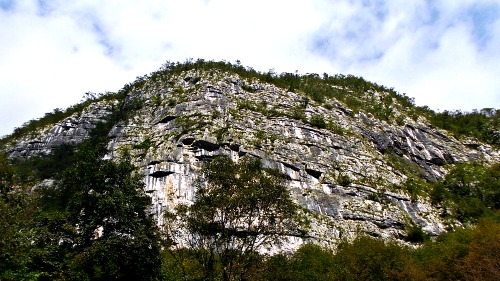
3. From the little church of San Tomè (northernmost point along the trail), the small valley of the Cunaz-Artugna changes direction completely, pointing towards N-E, and leaving to the left of the stream the mountains named ‘Crode di San Tomè’. This sub-vertical rock wall, about 100 metres thick and mainly composed of Cretaceous limestone – of which are well visible the stratifications (see picture below) –, is now mostly being used as a training ground by rock climbers. The above mentioned sudden change in direction of the valley’s upper section – known here as Valle della Stua – clearly indicates its tectonic origin; the Cunaz-Artugna stream, in its upper basin, coincides with a small fault line (fracture), generated by the more eroded nature of the terrain and known as Periadriatic Fault. This fault line – that continues in the S-W direction towards Mezzomonte (territory of Polcenigo) and Caneva, then passes through those localities – was originated by the deformations that more in general determined the uplifting of the entire Alpine chain.
Main Vegetation and Flora Aspects
The landscape that surrounds the trail is the complex expression of natural and anthropic transformations that followed one another over time: the natural ones are due to climatic changes, soil evolution and also the succession of the various plant communities, in their natural strive towards the best use of the available resources, while the transformations induced by man were due to the building of artifacts, as well as the intentional or involuntary interventions on the tree cover and the vegetation at large.
The San Tomè Nature Trail, in its short route, crosses at least five aspects of vegetation worth taking into account: 1) the area of the mill, with stable meadows and natural hedges that work as property boundaries; 2) the bed of the Artugna stream; 3) the broadleaved woodland, mostly composed of Hop Hornbeam and Manna Ash, with some Pubescent Oak and Hazel; 4) the rocky section, overhanging the trail; 5) the scree, with the presence of the grass Festuca spectabilis and of Geranium macrorrhyzum; 6) the reforestation patch, with conifers, by the church of San Tomè.
It is enough, however, to take a small digression – by entering the valley and raising a bit in altitude – to bump into (especially in spring) meadows covered in Sesleria varia, a grass that carpets the steep slopes of the mountain, rich also in beautiful blossoming of Wild Narcissi (Narcissus poeticus), Wild Peony (Paeonia officinalis), White Asphodel (Asphodelus albus), Gentians (Gentiana sp), Pinks (Dianthus sp) and Italian Gladioli (Gladiolus italicus).
It is evident that in these last few years, the outlook of this side of the Cansiglio-Cavallo outlying range – towering steeply above the small town of Budoia – has changed drastically, in response to the variations in land use. The cutting of grass in the ancient meadow lands – a secondary aspect following deforestation – had maintained, for a long time, these slopes devoid of trees. Even soil, impoverished by the continual removal of biomass, contributed to contrast the natural evolution of vegetation. The growth of shrubs and scrubby habitats that is currently taking place, favoured also by changes in land management, has brought about the gradual re-conquering of the slope by tree thickets, developed especially – for the major presence of humidity – inside the basin, and formed mostly by slender specimens of Hop Hornbeam (Ostrya carpinifolia) and Manna Ash (Fraxinus ornus), to which one must add – according to changes in the ecological situation – Pubescent Oak (Quercus pubescens), which is now found more and more commonly.
In this location, the flora of the arid meadows of the high plains of Friuli is limited to the colonization of the dry river beds (‘magredi’), while the polychromous arid lands typical of more elevated altitudes are confined here to the sections where rocks are exposed, and the presence of humus is therefore still quite scarce. Some of these aspects, in fact, fade – and sometimes intermingle –, making it difficult to distinguish them. Let us now look at these habitats in more detail.
1. The area of the mill, with stable meadows and natural hedges.
Stable meadows were once more widely spread in the whole area on fertile, well watered soil, but with an effective and deep drainage. In the past, these meadows would cover wide extensions, both over the plains and in the hills, becoming rarer instead in the montane band, which would nevertheless present rather favourable ecological conditions, because of the prevailing arid and calcareous soils. The dense grass cover includes several species belonging to the family Graminaceae, used in the past also as good quality fodder: Tall Oat-Grass (or Cocksfoot Grass; Arrhenatherum elatius), Orchard Grass (Dactylis glomerata), the Meadow (or Blue) Grass Poa pratensis, the Fescue Grass Festuca pratensis, Perennial (or English) Rye-grass Lolium perenne, the Tufted (or Meadow-soft) Grass Holcus lanatus, the Golden (or Yellow) Oat Grass Trisetum flavescens and Sweet Vernal (or Vanilla) Grass, Anthoxanthum odoratum. Other plants traditionally used as valuable fodder included Dandelion (Leontodon hispidus), Yarrow (Achillea millefolium), Bearded Hawksbeard (Crepis biennis), the Stars-of-Bethlehem (Ornithogalum sp.), Lady’s Mantle (Alchemilla sp.) – and others.
Of particular value for the high presence of protein content are also some plants belonging to the Leguminosae family, such as Red- (Trifolium pratense) and White Clover (T. repens), Bird’s Foot Trefoil (Lotus corniculatus) and various Vetches (Vicia species). The vegetation of these stable meadows is mostly formed of species that in Europe can be considered as native; however, in natural conditions, these plants would probably be rather rare and circumscribed to the most damaged woodland environments – those affected by landslides and the crashing of trees, either uprooted or damaged by the wind.
Instead, the action of man has spread these plants widely, and made them quite common throughout the plains of temperate Europe, over the hills and in the lower mountain slopes. The stable meadows of this area are in general of cultivated origin; the different species are being sown and often do not correspond to the wild populations (at least genetically); therefore, also the composition is affected by the initial human intervention. The natural tendency, here, is towards the reconstitution of scrub and broadleaved thickets, but this is blocked by repeated scything each year. The stable fields (or meadows) are delimited by natural hedges made of both shrub and tree species. Until not so long ago, hedges represented a characteristic trait of the landscape over the plains and in the hills – not just in western Friuli but in large parts of Europe as well (see this page for more information on hedges). Introduced during the Renaissance period as a way to mark boundaries, hedges have compensated for the progressive disappearance of the typical woodlands of plains and hills. Hedges present more ‘planes’ of vegetation, in a structural situation which is very similar to the edge of a woodland – areas which are, ecologically speaking, among the most noteworthy from the viewpoint of biodiversity.
2. The bed and the banks of the Artugna stream.
Pioneer scrub vegetation develops mainly where the stream has a chance to meander naturally, leaving deposits. It is mostly constituted of Willow species such as Olive (or Rosemary) Willow (Salix eleagnos), Purple Willow (or Osier; S. purpurea), Elder (Sambucus nigra), Juniper (Juniperis communis) and, among the herbaceous species, Butterbur (Petasites paradoxus), Coltsfoot (Tussilago farfara) and the grass Calamagrostis varia. During the spring, an extensive blossoming of Snowy Mespilus (Amelanchier ovalis) softens the stern, severe gravelly bed of the stream.
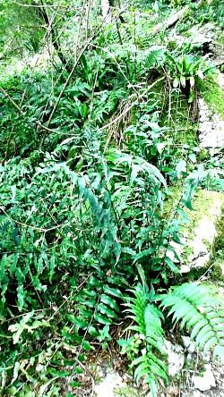
On a more curious note, along the banks of the Artugna stream one can notice a curious plant: it is a fern, known as Fortune’s Cyrtomium (Cyrtomium fortunei; see picture below). It is in fact an exotic species, whose aerial extends from eastern China to Korea and Japan. Used as an ornamental plant, it has since escaped cultivation and has become naturalised on damp, shady rocks in some areas of northern Italy, such as here in Budoia – but also on the Monte di Ragogna in central Friuli, by the Grotte del Caglieron in the Pre-Alps of Veneto and around Cannobio on Lake Maggiore.
3. The west-facing broadleaved woodland of Hop Hornbeam and Manna Ash.
The plant association led by Hop Hornbeam (Fraxinus ornus) belongs to the so-called termophile (warmth loving) species. In general, these are not ‘true’ woodlands, but rather mixed consortiums of tall shrubs and sparse small trees; the dominant species are Manna Ash (Ostrya carpinifolia) and Hop Hornbeam, to which are associated several other broadleaved. These formations develop mostly on calcareous soil, on locations exposed to the south, on slopes often degraded because of the frequent cuts and fires. In the most favoured locations – wherever there is a certain accumulation of humus – this type of vegetation shows the tendency to evolve towards ‘proper’ woodland, while the role of Hop Hornbeam and Manna Ash is progressively subordinated to the expansion of Pubescent Oak (Quercus pubescens).
4. Rocks overhanging the trail.
There are, present here, species typical of the rocky flora of the mountains, of a termophile type (that is, warmth loving plants), such as Spiked Bellflower (Campanula spicata) and Saxifrage Catchfly (Silene saxifraga). To these, must be added other species such as Common Mallow (Malva neglecta) and Spreading Pellitory (Parietaria judaica) – plants that are characteristic of built up environments (such as villages) and which also grow on rubble. These presences are all linked to the passage of grazing animals that once – during the seasonal movements known as ‘transumanza’ – would habitually find shelter under the jutting rocks.
5. The scree, with the presence of Fescue Grass (Festuca spectabilis).
This plant, belonging to the Graminaceae family – so characteristic for always presenting the dead leaves facing down-river, and for growing the new leaves towards the mountainside – is a good example of adaptation to difficult life conditions such as those found on scree; in fact, by sprouting new leaves always towards the mountainside, this grass thus opposes the slow but inexorable movement of the gravelly substrate towards the valley floor. Fescue is often associated with other plants that – in order to oppose such movement – have their ‘winning card’ precisely in the mighty root system, which is definitely out of proportions when compared to the dimensions of the aerial part of the plant.
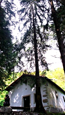
6. The reforestation patch with conifers by the church of San Tomè.
Here Lawson Cypress (Chamaecyparis lawsoniana) and Norway Spruce (Picea abies) hide to the view the small church of San Tomè. These essences – one of American origin, preferring habitats with an oceanic climate with high humidity, and the other typical of mountain environments – both contribute to create a thick woodland formation. The choice of these species for reforesting this small patch is more the mark of fashion and an approach to the territory linked to an ‘imaginary’ idea of mountain landscape – to which are quintessentially associated conifers – rather than the real plant associations found in these mountains; it is the product of a choice that was clearly not being made on the basis of a conscious and ecologically informed knowledge, but is symbolically meaningful of the type of interventions that were often made during the decades from the 1950s to the 1970s – in mountain settings especially, but not exclusively.
7. The church of San Tomè.
This small religious building can be seen above a rock boulder that takes its name from the church. It is an old church, which – in its original form – can be dated back to the 13th century; surely this location was already inhabited in ancient times. The place was protected, and the illegal digs that took place in 1959 – together with the more systematic ones that were carried out during the years 1964/5 – brought to light finds that could be referred to the Neolithic, Eneolithic: nuclei, burins (engravers), arrow points, small axes, bi-facials. The final Bronze age also gave fragments of vases and tronco-conical whorls. The findings of golden Roman coins (amongst which is one of Vespasianum; 69-79 AC), of arrow points and blades, as well as of numerous sepulchers with bones mixed with domestic tools, suggest that in Imperial Roman age there already was a small necropolis here.
On the small flat area in front of the church were excavated some other objects which could be attributed to the Medieval age (metal fragments of spurs, stirrups and buckles; ceramic fragments of amphora and whorls), perhaps connected to the frequentation of the building. It is difficult to establish for how many centuries this location has been a site of worship: the current church of San Tomè has been remodeled in the 1600s, but the first building apparently dates back to the 13th century; moreover, it is a working hypothesis – but likely – that on this site was already present a nympheum in Roman times (in other words, a small temple dedicated to water worship).
In origin, the church of San Tomè must have been much smaller, and presented – in the deep-end wall – a low apse, of which remain traces of the foundations, and the mark of the roof that covered it. In the past it must have been the object of frequent worship, as witnessed also by the frescoes, whose traces emerge under the plaster. It is narrated by local historian F. de Manzano that during the 14th century, as the inhabitants of Dardago were coming in great numbers to worship San Tommaso (whence the shortened name of the church, San Tomè), it was decided to enlarge the building; the apse was then suppressed, as it did not correspond to the centre of the deep-end wall anymore. In fact, the right-hand side wall was kept, as it was frescoed, but it was decided to rebuild both the left-hand side wall and the front wall (façade). The current little church of San Tomè is extremely suggestive in its simplicity (see picture below), as it is located amidst the vegetation and under a precipitous rock spur that has since become a training ground for rock climbers.
Return from Budoia to Italy-Tours-in-Nature

New! Comments
Have your say about what you just read! Leave me a comment in the box below.