- Italy Tours Home
- Italy Ethos
- Tours 2023
- Blog
- Contact Us
- Dolomites
- Top 10 Dolomites
- Veneto
- Dolomites Geology
- Dolomiti Bellunesi
- Cortina
- Cadore
- Belluno
- Cansiglio
- Carso
- Carnia
- Sauris
- Friuli
- Trentino
- Ethnographic Museums
- Monte Baldo
- South Tyrol
- Alta Pusteria
- Dobbiaco
- Emilia-Romagna
- Aosta Valley
- Cinque Terre
- Portofino
- Northern Apennines
- Southern Apennines
- Italian Botanical Gardens
- Padua Botanical Garden
- Orchids of Italy
Ovaro: Heritage and Nature Among the Rugged Mountains of Carnia.
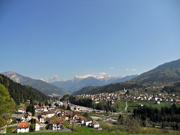
The aim of this page is to provide a guide to points of interest in the area around Ovaro. This town is situated in a wide basin in the middle of the Degano valley (Valle del Degano), also known as Canale di Gorto. It is surrounded by the mountain groups of Col Gentile and Arvenis to the east, while to the north Monte Volaia dominates. As it often happens in this area, the main town (capoluogo) is surrounded by several other smaller hamlets, scattered on the open basin (see image above).
Traces and finds reveal that this area was inhabited since Pre-historic times, and an inscription in Etruscan characters (dating to the 4-5th century) has been found. Celtic populations gave their name to several locations, including the name of the main valley (‘Gorto’ derives from ‘Guart’; “enclosed, protected space”). When the Romans won over the Carnian Gauls, the territory of Ovaro became part of their Empire.
Many of the small necropolis found in the area can be ascribed to late ancient times; most importantly, the Proto-Christian complex of San Martino (Saint Martin): here a building of wide proportions, dating to the 4th century, was found, and it included a baptistery and a basilica. This compound was abandoned during the Middle Ages, and the ancient Pieve di Gorto – originally located here (see below) – was rebuilt on a safer site, over the hill of Agrons (Colle di Agrons).
In the Middle Ages, Ovaro and its territory followed the destiny of the rest of Carnia, within Friuli, with the successive invasions of the Lombard and the Francs. The dominion of the powerful Patriarcato di Aquileia ensued, when the area was donated as a fiefdom of the Sacred Roman Empire. Since those times, the main activities were agriculture and artisanal crafts. The Pieve di Gorto was the main local authority, but later on the territory was divided among several other smaller churches.
Around 1420 Ovaro became Venetian, which guaranteed the state of semi-autonomy enjoyed previously. The centuries that followed were relatively quiet, given the marginal position of the area; the most significant event was the earthquake in 1700 that caused the reconstruction of several buildings.
The commercial activities were traditionally associated with the ‘cramars’ – sort of nomad pitchmen – and weaving (weavers also migrated seasonally to sell their finished products). The remittances – together with the relative peace guaranteed by the dominion of the Republic of Venice – allowed for a long spell of relative prosperity. Several families reached a certain level of wealth, and it is thanks to them if in the basin of Ovaro we can still admire today a high concentration of notable buildings.
As in many other communities around the Alps, land use was generally organized around a band of private land in the vicinity of the village, while woodland, pastures and meadows – further up the mountain slopes – remained of common property, and collectively managed. The thirteen hamlets around Ovaro – once known as ‘comuni’ – formed together a sort of local government ruled by a ‘vicinia’: an assembly of families representative of each ‘comune’.
The dominion of the Republic of Venice ended in 1797, when the territory became part of the Austrian empire (under the Hapsburg); in 1866 it finally became Italian. In 1917, during the bitter fights of WW1, the area briefly fell under Austrian rule again. In 1944 Ovaro was occupied by the Cossacks – allied of the Nazi-Fascists – and memory of their occupation is still vivid in the old generations; liberation only came in May 1945.
After WW2, the 13 small ‘comuni’ were gathered together, first under two municipalities (Mione and Ovaro), then eventually just one (Ovaro). As opposed to other communities in the Alps, here today the “common lands” are all but disappeared, apart from – party – in the hamlets of Ovasta, Liariis and Agrons. Seasonal emigration lasted well into the 1960s, then it gradually faded; the opening of a paper mill and the activity of a coal mine boosted the local economy – but successive closure of the coal mine represented a moment of crisis.
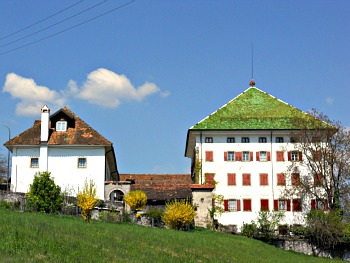
The main monument in Ovaro is the Pieve of Santa Maria di Gorto (read below), but there are also other important sites. Palazzo Micoli-Toscano is in the hamlet of Mione, which – with nearby Luint – is also notable for its vernacular architecture (see image above). This imposing building was erected by the architect Bassi in 1836 for one of the noble families of the area – the Micoli-Toscano – and it is known today as “Casa delle Cento Finestre” (‘House of the Hundred Windows’; described below) for its massive appearance and its panoramic location, almost suspended above the Ovaro basin. Because of its cubical form, it is quite a landmark even when seen from a long distance – but more than anything, perhaps, for its characteristic green, glazed tiles (see picture below).
The Casa da Corte – in the hamlet of Ovasta – is a typical example of Carnian vernacular architecture dating to the 17th century, while in the locality of Baus there is an old mill – still functioning – where one can admire, in the right season, the traditional way of grinding corn.
A few sites in Ovaro are connected with the initiative of Carnia Musei, such as the Museum of the Pieve of Santa Maria, the Museum of Wood and the Venetian Sawmill in Aplis, and the Miniera (coalmine) of Cludinico.
All three of them are described in more detail below; there is also a dedicated page for the Museum of Wood and the Venetian Sawmill in Aplis.
The Pieve and Museum of Santa Maria di Gorto
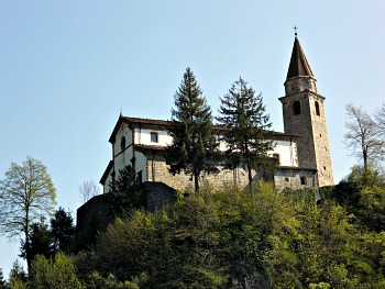
The Pieve of Santa Maria di Gorto (portrayed above) is situated on a hill where, according to some sources, a castelliere (fortified castle) existed since Pre-Roman times, and after that a military outpost. The toponym ‘Gorto’ is of Celtic origin, and apparently designates an ‘enclosed, protected site’. This may be a reference to the jurisdiction of the church, as the territory covered by the ancient Pieve was at once quite extensive and reached as far as Sappada, including the Val Pesarina and the Valcalda. This church is first mentioned in documents dating 1299, but its origins are likely to be much older – as demonstrated by the finds of some fragments of statues that can be referred to a site of worship dating probably to the 8th century AD.
The Pieve of Santa Maria was thought for long to be the most ancient building in the valley, but recent excavations by the small church of San Martino (north of town) have demonstrated that on this site existed a Paleo-Christian site of worship dating to the 5th century. That was most likely the location of the original Pieve, which was moved on a hilltop position only at a later stage for fear of foreign invasions and raids. Tradition has it that the new Pieve was built on the site – and with the material – of the dismantled Castle of Agrons.
On the same hilltop location where the Pieve of Santa Maria is now, at one time three other small churches existed, and they were later destroyed after being damaged by the 1700 earthquake; as a result, the Pieve was reconstructed and enlarged, finally taking the shape that we still see today. Damaging fires were certainly not a novelty for the valley; the church had already been devastated in 1370 and 1430, when it was first reconstructed (between 1430 and 1464).
The Pieve of Santa Maria presents itself today as a basilica with three naves that still host some important antiquities and works of art – such as frescoes dating to the 12-13th centuries, displaying the evangelical Parable of the Ten Virgins. There is a rich collection of artistic and liturgical items, and the archive is also worth mentioning, as it contains 140 medieval parchments – which bear testimony to the high consideration in which this building was held since ancient times.
In order to find a suitable location for these precious items – as well as for making some of them available for the public to see – a small museum was opened in 1973, hosted in a space beside the church. It is called “Museu da Plef” (‘Museum of the Pieve’), and it is composed of several sections, plus a Lapidarium. The most ancient piece in the archaeological section is the so-called “Lavara di Cjanaia”, which is a fragment of Pre-Roman tombstone with an inscription that has not yet been fully deciphered, but may be of Etruscan – or possibly Venetian – origin (that is, referred to the ancient people of the Veneti).
This may suggest that the church was located along an important route and occupied a strategic position; as remarked before, this was the site of a ‘castelliere’, then of a Roman ‘castrum’, and later still of a medieval castle. Another important relic conserved in the Museum are a couple of statues known as the ‘Pipinacui’ – a mysterious representation of two praying figures, carved in a local tufa stone (improperly called “Dolomia cariata”): their primeval, almost barbaric typology of representation suggests a Pre-Christian origin.
The Museum was later enlarged in the rooms of a former dairy building (Latteria), and here are further objects: bronzes, silverware, vestments, fabrics, pieces of furniture and wooden statues. Amongst these, particularly noteworthy is a wooden sculpture by Domenico da Tolmezzo, representing Saint Martin and the Poor (early 1500s). There is also important evidence of local baroque art – for example, a 17th century tabernacle in gilded wood and a 16th century Crucifix. To this same period date two paintings on silk, an altarpiece showing an interesting early view of the valley with all its churches, and two wooden panels representing the mysteries of the Holy Rosary.
The Museum of Wood and Venetian Sawmill in Aplis
Another attraction that belongs to the “Carnia Musei” network is the Museum of Wood and Venetian Sawmill in the hamlet of Aplis (about 3 km to the north of the town centre).
In the last few centuries, woodland habitats have provided a fundamental resource for the life and existence of the local population in many communities throughout Carnia. The primary resource was, of course, wood itself, but there was also a whole range of secondary products too.
The phases of work in a wood factory are being documented here. The process starts with the ‘martellata’ (hammering): the trees that are to be felled are first chosen; then, as the actual felling has to take place in a certain direction, this must be established with a mark, in order to determine where a tree is exactly going to fall – as the first phases of work actually happen right on the spot.
The phase that follows is the ‘esbosco’ (removal): this includes all those operations through which timber is brought to the loading platform, to be taken to the sawmills.
Exploitation of wood around Ovaro is well documented since at least the 1700s. In the Canale di Gorto 9 to 11 sawmills were operating, near all the main villages. Aplis was one of them, and it was part of quite an important compound, which included a watermill, two sawmills and a small barn. It was operative – according to documents – by 1755, so that today it represents an artifact of historical value. Refer to the dedicated page on the Museum of Wood and Venetian Sawmill for more information.
In Carnia, most sawmills were of the Venetian type – which is what can also be seen throughout nearby Cadore, with wheels operated though the use of hydraulic force. A single wheel, activated by water, supported a blade and a cart on to which the raw material was laid; the cart, as it advanced in the direction of the blade, caused the actual woodcutting.
Aplis: A Small Rural Community
In this same hamlet of Aplis – besides the Museum of Wood and Venetian Sawmill – there is also an exhibit on the local fauna. It is quite an large collection with more than 100 specimens, mostly comprising species of local birdlife. The two exhibitions are complemented by a residential compound that turns this village into an ideal base for excursions or for a more relaxed stay, immersed in nature.
The set of buildings situated today in the locality of Aplis consists of an ancient site in which were carried out a series of productive activities connected with the rural economy of Carnia during the 1700s and 1800s. In fact, in this location were once found a saw-mill, which constituted the hub of productive activities and that functioned thanks to water power, funneled via a canal on a blade wheel (hydraulic wheel); a furnace for the production of quicklime, used as material to tie stones together (when used for building); a mill combined with the cultivation of the fields for the production of flour; stables for the shelter of cows and horses – the latter used also for the pulling of carriages and the dragging of timber in woodwork and in forestry; a pentagonal kitchen garden for the cultivation of land produce and officinal herbs (described in more detail below); springs of very pure water, channeled to assist in the raising of trout and river shrimps (with the creation of fisheries); a building to host the workers.
The so-called ‘Aplis model’ can be framed within the context of an autarchic farmer’s life, and the centrality of the patriarchal family, which both knew how to articulate the presence of diverse components in the different productive sectors: in agriculture; in animal breeding and farming; in forestry and woodland management – while maintaining all this within the context of a balanced relationship between man and the environment. The realization and restoration of the Aplis site – besides a touristic function – takes on therefore a role that could be termed as historic, and testimonial in respect to the old ways of life of the rural populations in Carnia, which deserve not to be lost but rather conserved for present and future generations.
It can be assumed, as a working hypothesis, that the kitchen garden in Aplis – with its singular pentagonal shape – was destined, besides cultivation for land produce, also to the raising of officinal herbs. The latter, accompanying man, his life and evolution since time immemorial, include the aromatic plants, the medicinal use and those species from which essences can be derived. Numerous historic sources attest that officinal herbs were known already since antiquity, and use of them was made by Pre-Christian civilizations (such as the Greek and the Roman) for religious, social and practical purposes. It is assumed, in fact, that besides their utilization as spice and for daily use in cookery, officinal herbs were used also to conserve and flavor various foods, as well as being medicinal products for their own sake, able to bring relief and benefit to those in need, at a time when the cure of various illnesses and ailments depended almost exclusively on herbs.
The project of restoration of the kitchen garden has implied the arrangement and consolidation of the wall structures and of the stone stairs, as well as the substitution of the soil with new vegetal matter.
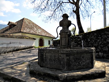
The observatory on the ‘Risorgive’ has been carried out by recovering an existing building, which was originally destined as storehouse. The value of the building consists also in the pleasant situation in which it is located, as it is positioned between the two main resurgent pools of water (‘risorgive’) of the area. From the ample glass walls of this building it is possible to observe – besides the ‘risorgive’ – several specimens of trout that have found in these waters an excellent habitat.
The Palazzo Micoli-Toscano
This building, sited in a commanding location, is a good example of an Alpine manor, although the structure follows the typical layout of a Venetian villa. Known right from the beginning as the “Casa delle Cento Finestre” (‘House of the Hundred Windows’), it was erected at the beginning of the 19th century (precisely in 1836) as a replacement of a previous, humbler 14th century dwelling built by the same Toscano family, who still own the palace today and who came originally from Tuscany precisely to avoid the plague, raging at the time; having become rich, they built the palace in order to better represent their wealth. The palace is a single building with a square plan, on four floors that feature windows alternating with pilasters. The symmetry of the main façade is underscored by two lines of windows flanking the central part on both sides, featuring mullioned windows. The main floor is highlighted by rich window frames, and it is linked to the upper floor by pilaster strips; the attic is used as granary rooms. The central hall, enriched with frescoes, does not occupy the whole depth of the interior, thus leaving some space for another room at the back. To the west, the building known as ‘Burgos stable’ (Stallone Burgos) is also a valuable example of minor 17th century architecture.
The Museum of the Coalmine in Cludinico
The hamlet of Cludinico is laying on a series of coal deposits – a vein that, despite having varying levels of depth, extends nonetheless all the way almost to Tolmezzo. The coal deposits that were individuated in Cludinico over the years are three (“Rio Malon, Valeton and Creta d’Oro”), and exploitation of the vein started at an artisanal level in the latter part of the 1700s. But it is only at the beginning of the 19th century that concession was given to exploit the coal seam on an industrial level. After that the extraction took on, and reached a peak in the years immediately after WW2. It wasn’t long, though, until a reversal of fortunes quickly happened – to the point that the mine eventually closed.
Now, some of the galleries have been restored, so that visits are possible again – but of course, this is not a working compound anymore, and so the visits are purely for historical and educational purposes. The ex-coalmine is now listed among the most prominent sites on a regional level for both mineralogical and geological interest.
The museum brings to a perfect completion the process of valuing the mineralogical site at Cludinico. Its ideal location is in one of the few buildings of the mining village that has survived the alternating historical events linked with the exploitation of the coal vein. Recently restored, the building hosts an exhibition and a video, plus other facilities for study meetings and conferences.
When one visits this museum, one immediately finds oneself shrouded in darkness – and this is done on purpose in order to have visitors experience what it was like to work in the coal mine. After that, the processes involved with the coal mining industry are unveiled in all of their phases. To complement the existing documentation, various attestations and testimonies are also being added on a regular basis – supplied mainly by former miners and their families.
The explanatory signs and labels too are accompanied – whenever possible – by several finds, in order to give real evidence of what used to happen and how life used to be in the mining village. In the room on the first floor a screening is taking place, which also aims at faithfully reconstructing the life condition of the miners in Cludinico.
Of the three mining sites mentioned above, one of them (“Creta d’Oro”) can be visited. It is disposed on four levels: a path leaves from the hamlet of Cludinico, descends for about 200 m, and leads to the entrance of the subterranean section, where the actual visit begins. Once entered the mine, there is a route to follow within the mine itself, which is about 1 km long, and all in gallery. Gradually, this leads to upper levels, and one regains the exit from the top, where another stretch of path goes back towards the village.
Excursions can be taken from around Ovaro to the surrounding mountains, such as Monte Arvenis (1,968 m; 4.30 hrs), Monte Avedrugno (1,533 m; 4 hrs), Monte Zoncolan (1,740 m; 4 hrs; this is reachable also from Ravascletto with a cable car, and affords quite an extensive view over the whole region) and Monte Tamai (1,970 m; 4.30 hrs), passing some natural springs along the way.
Old Buildings in Comeglians
Palazzo De Gleria
This 18th century building lies in an isolated location in the hamlet of Povolaro, with a garden that separates it from the main street. Its architecture is influenced by the Venetian design of that time. The façade is laid out along a vertical central axis that lines up the entrance gate’s round arch with a wider stone frame, worked in Baroque style patters; a square mullioned window on the first floor; and a stone balustrade balcony, supported by decorated corbels on the second floor. Two clocks with painted faces enrich the façade. The horizontal alignment of the windows is underscored by violet painted bands. The original core of the building has a rectangular layout, divided into three main areas with four aspects. Other wings were added at the back, thus modifying the building’s plan, which is now L-shaped. The internal layout is organized around a central space, from which the rooms can be accessed. Two parallel stone stairways are also in line with the entrance.
‘Cjases Cjargnelis’ (Carnic Houses) in Povolaro
The hamlet of Povolaro – already known in the Middle Ages under the name of Villa di Povolaro – has maintained its unspoiled, original layout, which came to be during the 17th and 18th centuries along the main road that crosses the settlement.
The Casa del Degano – probably built in the 18th century – is rather peculiar, both because of the layout that is organized along a central corridor, and for the presence of a secondary internal stairway. The ground floor comes with a porch flanked by stone arches; the upper floor features a loggia with three smaller arches, also in stone.
Not far away is the Casa Palmano, also known as ‘Casa di Florean’, which is separated from the road by a garden delimited by a stone wall. It was built between the end of the 17th century and the beginning of the 18th century. The interior features a symmetrical layout of the openings along a vertical central axis.
The Casa Paschina-Palmano, sited on a widening of the via Povolaro (the village main street) – whose original shape was modified by an addition on the southeastern side – was also built in the 17th-18th centuries. It felt the influence of the Venetian architecture of the time; its plan is rectangular, and the interior layout revolves around the central room, which contains the stairway too.
Return from Ovaro to Italy-Tours-in-Nature

New! Comments
Have your say about what you just read! Leave me a comment in the box below.