- Italy Tours Home
- Italy Ethos
- Tours 2023
- Blog
- Contact Us
- Dolomites
- Top 10 Dolomites
- Veneto
- Dolomites Geology
- Dolomiti Bellunesi
- Cortina
- Cadore
- Belluno
- Cansiglio
- Carso
- Carnia
- Sauris
- Friuli
- Trentino
- Ethnographic Museums
- Monte Baldo
- South Tyrol
- Alta Pusteria
- Dobbiaco
- Emilia-Romagna
- Aosta Valley
- Cinque Terre
- Portofino
- Northern Apennines
- Southern Apennines
- Italian Botanical Gardens
- Padua Botanical Garden
- Orchids of Italy
Paularo: a Quirky Museum,
Old Traditions and Unexplored Nature in Carnia’s Heartland.
Paularo is situated in an open basin surrounded by mountains in the middle section of Carnia, at the head of the Canale d’Incaroio. There are several interesting sights to be enjoyed in the area, both from a naturalistic and a cultural point of view.
In the centre of the village there are several examples of old houses that count amongst the most interesting examples of Carnian vernacular architecture in the region. Built in the Canale di Gorto type – and therefore mainly in stone – the influence of the Venetian architecture is clearly visible in them.
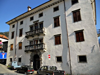
This is also evident in the noble architecture – such as in Palazzo Fabiani, right in the centre of town (pictured above), which dates to the 17th century: even though it was erected originally as a private mansion, at a later stage it became an inn, which in the 1800s hosted also famous personalities of the time – such as poets Giosué Carducci and Caterina Percoto.
A particularly noteworthy example of these buildings is Palazzo Scala, home to an unusual, quirky little museum called “La Mozartina” – an epithet that in Italian could be translated as “(The) Little Mozart (House)”, and a clear reference to the fact that its dominant theme is music, as the collection hosted here is mainly composed of musical instruments. The origins of Palazzo Scala date back to the 16th century, but it was almost completely rebuit after the damaging fire of 1709 – when several localities around Paularo were ravaged by fire.
This captivating little exhibition is the creation of Maestro Giovanni Canciani, who was born here in 1936; his goal was that of representing the history of keyboard instruments with a dedicated museum – and there are definitely some notable specimens to be seen here, like a ‘Testa’ organ that according to tradition was played by Handel and Scarlatti.
In the so-called “Carnian Room” a ‘Kaeferle’ table-piano is displayed, then a ‘Kriegelstein’ that is particularly relevant for the innovations to the mechanics and to its supportive structure. In the “Little Concert Room” one can admire a ‘Lipp’ piano, which – according to legend, at least – is haunted, while in the “Composers’ Room” there is an ‘Erard’ piano – apparently the brand preferred by Beethoven. The “Genovesino Room” is dominated by two notable Genoese paintings from the 1500s, and displays some unusual instruments of Nepalese provenance, alongside ancient prints and manuscripts.
The “Mozartina” museum is part of Carnia Musei – the network that brings together the most significant exhibits throughout the region of Carnia.
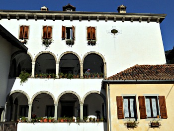
Other notable sites in Paularo town centre include Palazzo Calice-Screm, which dates to the 16th century, and that can be considered the prototype of the Carnian house, structured around several buildings (it is portrayed in the image above). Its most interesting part is the central section, which is built around arcaded loggias, supported by pillars in local stone. This building was erected by the Venetians in 1591, when the family came to this area to manage the woodland.
The “Cort di Tarusc” in Villadimezzo is a small square surrounded by typical vernacular buildings dating to the 17th century.
The scenic Palazzo Valesio-Calice dominates from a hill the hamlet of Villafuori; it has two wings and is built around an enclosed garden protected by high walls.
The Chiarsò valley
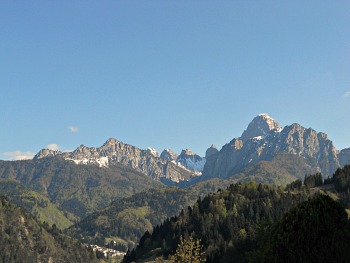
The Paularo basin is surrounded to the north by Monte Sernio (2,187 m), Tersadia (1,959 m), Zermula (2,143 m) and Dimon (2,043 m); to the west is the Cimon di Crasulina (2,104 m); Monte Salinchiet (1,857 m) is to the east (see an image og the mountains around the Paularo basin above).
The area is crossed by the Chiarsò valley (Valle del Chiarsò or Canale d’Incarojo) – a territory which is fairly homogeneous for its naturalistic, environmental, socio-cultural and economic features. In the last few years – owing mainly to the initiatives of the municipality of Paularo – this area has become known as the valley of the ‘Mistirs’, which in the old language of Friuli means ‘trades’.
It is a territory that offers in fact many opportunities for acknowledging oneself with various activities of yesterday and today. The representations and exhibitions are complemented by a traditional event that takes place each year, when the town of Paularo and its hamlets become the stage for a display of several trades, and of various traditions linked with them. With this goal in mind, the atmospheric setting of the ex-church of Sant’Antonio is – since 2004 – home to another initiative: a display known as “Ecomuseo” (Ecomuseum), which aims to show – with the help of images – the most representative features of the valley from a naturalistic point of view, as well as illustrating the traditional trades and their connection with the land.
Across the territory of Paularo municipality there are several sites, which are linked to the “Ecomuseum”, that can be visited: for instance, a trail leads from the hamlet of Salino to Ravinis; in Salino itself there is an historical watermill. Near the centre of Paularo one can see an old cable car, created a few years ago and still in perfect working order: examination of how this tool was used and of its functioning allows the visitor to become acknowledged with building techniques of old times. Timber production and other woodland crafts are demonstrated with a small exhibition around the figure of the lumberjack, which has been set by the headquarters of the local Forestry Commission (“Corpo Forestale”) in Villamezzo.
There are also several excursions to be enjoyed in nature in the Chiarsò valley, which is about 15 km long and has a network of twenty organized trails. There are ten peaks around 2,000 metres of altitude, plus seven plateaus with pasture grounds – amongst which are the Piani di Lanza – and also five ancient forests. Soil types are very varied, and of different origin: glacial to the south, volcanic in the centre of the valley and more distinctly marine towards the north, with waterfalls and gorges.
Two orogenetic processes have shaped the area, and are both visible: the section of the basin where the main town of Paularo is located is mainly constituted by deposits of the Bellerophon Formation, dating 250 million years ago (Superior Permian), which owes its name to a fossil. Going up the Chiarsò valley, one encounters older soils: sandstone deposits of the Val Gardena Type at first – bearing testimony to a phase of warmer climate – while further north a mixture of sedimentary and magmatic rocks dating to the Carboniferous (320 million years ago) emerge. Even older are the limestone dating to the Devionian (350 million years ago), linked to deep sea deposits and the presence of cliffs (an example is on Monte Zermula). These rocks are particularly rich in fossils, for which the territory of Paularo is renowned (some of them are now on display in the Geological Museum of Carnia, in Ampezzo). The oldest rocks in absolute are those of the Uqua Formation, which come to the surface around Casera Valbertad, and that – dating 450 million years ago – are the oldest rocks in Carnia.
Historical Facts
Because of the limited written documentation, it is difficult to reconstruct the historical events in Paularo, as this territory was largely affected by various events that hit the town and its surroundings (the most dramatic being perhaps the fire of 1709, that destroyed the hamlet of Villamezzo).
The territory of Paularo seems to have always been an area of transit, and it bears traces of the presence of man since very ancient times. Objects in flint – dating to the Middle Paleolithic – were found, while other instruments of the same material – but which can be referred to the Mesolithic – were discovered around Casera Valbertad, at an altitude of around 1,600 metres, in the proximity of the Cason di Lanza Pass.
The archaeological digs that were carried out in Misincinis between 1995 and 1999 have brought to light a significant amount of finds, dating between the end of the 8th and the 1st century BC. In particular, 145 tombs have been found, belonging to a necropolis whose contents can be referred to the so-called “La Tène Civilization”, which bears witness to the presence of Celtic people in the area.
Among the evidence of late-Roman settlements is the finding of a tomb – always in Misincinis, of a paved road and a fortress in Chiastilirs (probably a ‘castelliere’, as the name would suggest), near the hamlet of Dierico.
The three fortresses that for centuries have provided a defense to the town are represented in its coat of arms: the first is the tower on the Duron area – a location which was instrumental in connecting the valleys of Treppo, Paluzza and Valcalda; the second is the fortification near Dierico mentioned above – in a position that dominates the narrow passage of the Canale d’Incarojo – and the third one is the site of a former Pagan temple, over which the main church of Paularo now stands.
The prosperity of the valley is linked to the domination of the Republic of Venice, which started in 1420, when the “Serenissima” saw in the woodlands of Carnia a source of richness for its shipbuilding industry.
After that, in the 1700s Jacopo Linussio – the greatest entrepreneur of the textile industry in Carnia – started his activity here; it was a very florid time for this territory. On the contrary, the Napoleonic domination first and the Austrian rule after (under the Hapsburg) were times of great uncertainty; this is when most of the industries declined and many of the local inhabitants emigrated.
When Paularo and its territory were finally annexed to the Kingdom of Italy in 1866, the locality soon became a popular destination for tourists and even some notable personalities – such as poets and writers Giosué Carducci and Caterina Percoto – sojourned here.Tourism declined after WW2 and the area went through a phase of decline, but now there are promising signs of recovery, thanks to the cultural activities mentioned before and also other initiatives.
Paularo and its ‘frazioni’
The local economy is based mainly on artisanal activities – especially woodworking – and tourism. In 2007 the “Albergo Diffuso” was inaugurated, with twelve lodgings obtained from various old houses around the hamlets of Ravinis, Salino, Dierico, Villamezzo and in the centre of Paularo itself.
The municipality of Paularo consists of several ‘frazioni’ (literally fractions – that is, subdivisions; hamlets) – such as Casaso, Dierico, Misincinis, Salino, Ravinis, Chiaulis, Castoia, Villamezzo, Villafuori, Rio, Cogliat, Lambrugno, Tavella and Trelli. Some of these hamlets have an interesting story to tell:
– Casaso is known as the “Cence lune” – the ‘village without the moon’ – as it lies in a location that does not easily allow its light to shine.
– The hamlet of Chiaulis, situated at the base of Monte Tersadia (1.959 m), derives its name from the word “Cèvole, Cèule”, which in the ancient idiom of Friuli (Friulano) means cave, precipice.
– Dierico is the biggest hamlet after Paularo itself – so much so that once it was an independent community (‘Comune’) of its own. It lies at the foothill of Monte Sernio, the ascent of which can be made through paths that bear characteristic but strange names in Friulano – such as “Dioor, Fuarmi, Cjaf da L'Omp”. From there, many other trails leading up in altitude can be taken – and these also have peculiar names (“Faul, Felet, Plan da Baree, Chianipade, Turries and Forcje”). Another linguistic peculiarity of this hamlet is its strong pronunciation of the letter ‘r’ – very similar to French.
– Misincinis is famous for its archaeological finds (see above); here, in 1995, the remains of a necropolis dating back to the 7th century BC were found on the road that leads to the Passo di Lanza. Worth visiting is also the iron-water spring in the vicinity of Rufosc; this spring can be reached via a track off the road to Ravinis.
– Ravinis is spread along the slope of Monte Zermula (2,143 m). The name of this hamlet seems to derive either from the Latin ‘rupum’ (turnip – perhaps a reference to the vegetable that was cultivated here at one time) or the more likely ‘ripa’ – slope. For its old houses, this village is a real jewel.
– Salino: the name of this hamlet may be a reference to a ‘salty spring’, but it could also refer to the soil – ‘rich in salt’, or even ‘sterile’. This is where the poet Caterina Percoto used to spend her holidays. There is a striking waterfall on the way to Paularo town centre.
– Villamezzo (‘Vile di mieç’ in Friulano) is the most important of the ‘frazioni’ – subdivisions – that form Paularo; nowadays, it is so inextricably linked with the town centre that it is difficult to tell where one finishes and the other begins. The old part of Villamezzo is laid on the northern flank of the valley, under the ancient fields of Plais and by the wood of Sortisella. Both Villamezzo and Dierico were once autonomous municipalities that were only at a later stage united with Paularo.
Return from Paularo to Italy-Tours-in-Nature

New! Comments
Have your say about what you just read! Leave me a comment in the box below.