- Italy Tours Home
- Italy Ethos
- Tours 2023
- Blog
- Contact Us
- Dolomites
- Top 10 Dolomites
- Veneto
- Dolomites Geology
- Dolomiti Bellunesi
- Cortina
- Cadore
- Belluno
- Cansiglio
- Carso
- Carnia
- Sauris
- Friuli
- Trentino
- Ethnographic Museums
- Monte Baldo
- South Tyrol
- Alta Pusteria
- Dobbiaco
- Emilia-Romagna
- Aosta Valley
- Cinque Terre
- Portofino
- Northern Apennines
- Southern Apennines
- Italian Botanical Gardens
- Padua Botanical Garden
- Orchids of Italy
The Val Canzoi – a Picturesque, Rugged Valley Nestled Within the Dolomiti
Bellunesi’s Green Heart.
The val Canzoi is One
of the Park’s Main Gateways
Among the noteworthy valleys of the Dolomiti Bellunesi National Park, the val Canzoi (or val di Canzoi) is distinguished by the quality of its natural habitats (woodlands, meadows, riverbeds, karstic springs), further enriched by the discreet presence of small niches of old rural settlements, and the numerous traces of past and recent human activities (trails, mule-tracks, cultivated patches, old rural buildings, dry stone walls, terracing – as well as the ‘casere’, traditional dairy pens).
The val Canzoi is an archaic and picturesque microcosm, originated by the confluence of a network of steep valleys that score and drain the southern slopes of the Cimonega group (2,547 m), forming a valley system deeply inserted within the Park’s heart.
The val Canzoi cuts transversally into the entire stratigraphic layer succession of the Dolomiti Bellunesi, thus allowing one to observe its main rock formations – from the Scaglia Rossa at the valley entrance to the Main Dolomite at its core.
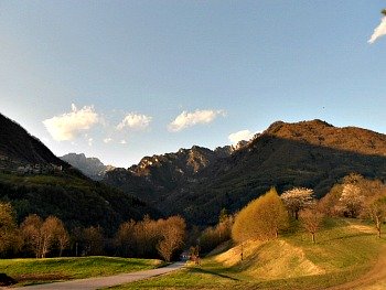
The val Canzoi starts just outside Cesiomaggiore as a wide verdant valley (see the image above) among meadows and small patches of cultivated land, but then it soon enters a deep narrow canyon among vertical rock faces.
As it often happens with ancient valleys, the val Canzoi is a complex environmental system, to whose morphologic evolution have contributed several factors: glaciers, water courses, slopes’ degradation processes (landslides and erosion) and, locally, karstic corrosion too.
The glacial moulding – mainly due to an inserted branch of the ancient Piave glacier during the culminating phases of the glaciations – is recognizable by the vaguely ‘U-shaped’ valley’s transversal profile, reflected in the relatively ample valley floor and steep side slopes.
A narrow street enters the valley, allowing – with only short side digressions – to explore some noteworthy environments; notably:
a) St. Eustachius’ Pond, which lies in a small depression limited by a sinuous hillock made of detritus, and constituted mainly of glacial deposits (a morenic embankment);
b) the karstic spring of Fraina Bassa, whose waters – gushing forth from Main Dolomite bedrock – lazily drain and expand into an ample pool with Alpine newts and frogs, to eventually merge into the Caorame stream.
The gorges at Ponte Umin and La Stua are also incised in Main Dolomite rock layers: these are deeply-cut canyons that the Caorame had to carve following the occlusion of the old valley floor due to material brought and accumulated by a side stream (in the case of Ponte Umin), or by fluvio-glacial deposits;
c) the evorsion pot-holes and the Caorame waterfalls, along the trail to Casera Cimonega;
d) Grey clays, emerging along the Caorame stream and elsewhere, witness the existence – in the past – of two lakes, long since disappeared, most likely formed by landslides (acting like natural dams), and the presence of a fan (or conoid) made of transported materials.
Some fault valleys are structured in correspondence with bands of fractured rocks which are easily eroded; in some cases, the presence of these faults is highlighted by the unusual confluence of water courses against the natural flow;
e) the Cansech plains are prairies and meadows – delimited by a steep detritus’ slope – that correspond to an ancient fluvio-glacial terrace (gross moraine materials set in motion, which were later re-deposited by the water courses once the glaciers retreated).
The val Canzoi Nature Trail Circular Walk
In the val Canzoi the Dolomiti Bellunesi Park authority has devised a circular route (the Val Canzoi Nature Trail), which will help one become acknowledged with some of the main characteristics that can be admired within the territory of the National Park, and it is therefore one of the best introductions to its nature.
The Val Canzoi Nature Trail is an easy track which can be walked by almost anybody and that starts by a pic-nic area known as Preton, in the vicinity of a small bridge by the road. The path will first take you to some old rural buildings, then it rises against some rock faces that host some interesting plants (amongst which is Veselskyi Campion, Silene weselskii – a species endemic to the area).
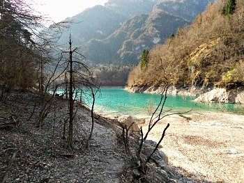
Meandering among patches of beech woodland, and through remnants of old spruce plantations (you will notice how much poorer these latter look, in terms of biodiversity), you will go past some more dilapidated buildings (dairy farms that testify to the intense use of these lands in the old days), until you eventually reach the banks of the lake of La Stua (Lago della Stua), whose waters – although the basin is artificial – are always of a mesmerising turquoise colour (see an image above).
After you rested by the lake shores for a while, another stretch of path will take you down to the valley floor, from where you have the option of leaving the trail and continue in altitude towards the high plateaus of Piani Eterni (the mythically, aptly named Eternal Plains).
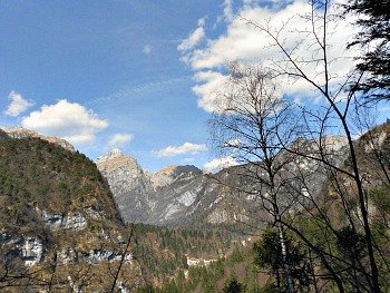
Carrying on along the circular route instead, you will now enter the woodland again, climbing on the opposite side of the valley until you reach a panoramic viewpoint (see below an image taken by the viewpoint along the circular trail); after that, the sight opens up on to a meadow, where more rural buildings (here known as casere) are situated: these are the so-called Piani di Cansech (the Cansech plains, mentioned above).
After this, the path will take you back down to the valley floor, where you bear right and go past some hydro-electric plants as well as the ruins of a lime kiln (quicklime production was a typical activity in these areas in ancient times), to eventually reach the point where the trail started.
All in all, this circular route should take you about four hours to complete, allowing you to get a good introduction on all the main elements of the Park: flora, fauna, geology – and the human aspect too. A general and detailed presentation of the Val Canzoi Nature Trail follows, but by clicking on the link you will also access a dedicated page.
General Presentation of the Val Canzoi Nature Trail
Stratigraphy and Tectonics. The deep cut of the val Canzoi is carved – above Ponte Umin – in the solid Triassic banks of Main Dolomite (‘Dolomia Principale’; 220-205 million years ago). This lythotype (type of rock) was once widespread in the mountains of the Veneto, and it is constituted by a powerful succession of layered Dolomite – white or greyish-white in colour when freshly fractured, while it becomes grey or greyish-black when altered by atmospheric agents. Around the deepest and most ancient nuclei of Dolomite are conserved the most recent rock formations.
Grey Limestone dates to the Lower Jurassic instead, and it surfaces on the rock faces of Monte Colsento (2,021 m) and Passo Finestra, at the Pale del Lenzuolo and Lenzuoletto, on the basement of Comedon and Sass de Mura (2,547 m) and towards the exit of the valley, after Ponte Umin. This is a succession of limestone of various colours (generally white, grey or pink; often the grey colour is due to alterations), whose thickness is of around 400 metres. The huge banks – visibly layered – are often of a uniform ash-grey colour, and these fade at the base of the formation into the Main Dolomite, from which they are not easily distinguishable from afar. On the walls of Monte Sviert, Col dei Bechi and on the eroded slopes of the Caserin, the sharp decrease in the slope’s gradient is to be put in relation with a change in lythology. The compact and resilient layers of Grey Limestone are substituted there with other formations in thinner layers, like Lower Ammonite Red (Rosso Ammonitico Inferiore) – which here has a thickness of about two metres – and the Calcare Selcifero di Fonzaso, a type of limestone whose grey-green layers rich in flint are protected by the powerful frame of Upper Ammonite Red (Rosso Ammonitico Superiore).
The so-called Biancone belongs to the Lower Cretaceous (140-100 m. y. a.), and with its softer greyish-white limestone layers it is the substrate over which are moulded the steep overhanging meadows, while at the foot of the Dolomite walls of Sass de Mura is a small patch of Scaglia Rossa (Red Scale).
The Scaglia Rossa surfaces along the road in an area known as Le Ave, where its thin layers are intensely and curiously folded. The Biancone can also easily be observed a short distance afterwards, in equally tectonically disturbed layers.
The val Canzoi crosses entirely the Anticlinale Coppolo-Pelf – an important fault-line responsible also for the elevation of the Vette Feltrine and the Dolomiti Bellunesi. This complex tectonic structure can be reported back, in simplistic terms, to a huge asymmetric fold whose convex side is pointing upwards; its southern flank – from Le Ave until the Stua lake – shows, especially at the periphery, layers that are strongly inclined towards the south. On the contrary, at the centre of the fold the layers are not so inclined; in fact they are almost horizontal. The northern flank is affected by more modest inclinations, also pointing towards the north (see below an image of the rock formations encountered along the Val Canzoi Nature Trail).
Geo-morphology. The val Canzoi is a complex system, quite evolved and with a rich variety of geo-morphologic settings. This valley is also relatively old, and it has been going through several erosion cycles. Many factors have contributed to its moulding – almost all of the main morphogenetic agents have affected it: water courses with their erosion and the subsequent accumulation of material they caused; valley glaciers, which repeatedly invaded the valley during the Quaternary glaciations; slopes’ degradation processes (landslide, erosion, etc) and karstic corrosion too. The glacial morphogenetic action is recognizable in the mild “U-shape” of the valley (steep flanks and relatively ample valley floor) and in the quite frequent presence of moraine deposits, often re-immobilized by the water courses.
The head of the val Canzoi is constituted by a group of incisions that cut with deep profiles the southern side of the Cimonega group (these are known as “scarp valleys”). The morphologic traits of these valleys are quite ‘young’, craggy and in continuous active evolution (in some cases, it is really a question of “active erosion basins” – as in the case of the Val Scarnia, Val di Neva and Val d’Alvis).
From the locality of Preton – after an initial stretch – the trail develops along the alluvial valley floor of the Caorame stream: this is an inter-valley alluvial plain, constituted by a succession of fluvial deposits with gross texture (sandy gravels, pebbles, some boulders), deposited by the water course during light or more extreme flood events.
Vegetal Landscape. The Val Canzoi Nature Trail is a circular route that unfolds in the middle section of the valley and that, without too much effort, allows one to cross environments and habitats of assured floral and vegetational value. In this small side valley, conditions of high air humidity favour those species which are more characteristic of narrow habitats (such as canyons); amongst these, the showy Yellow Day Lily Hemerocallis lilio-asphodelus, the delicate Scented Bellflower (Adenophora liliifolia) and the poisonous Black Veratrum (Veratrum nigrum) are all observable in several locations along the way.
There are also sections of noteworthy botanic relevance, with the presence of rare or particularly significant species, amongst which stand out Veselskyi Campion (Silene veselskyi), Asplenium of the Dolomites (Asplenium seelosii), Honesty (Lunaria rediviva) and the already mentioned Yellow Day Lily and Scented Bellflower, to which one should also add the stunning blossoms of Alpine Devil’s Claw (Physoplexis comosa; some of these plant species are explained in more detail below).
The vegetational landscape is quite varied; one can observe scree generated by landslides, which have been colonized by pioneer plants; typical sub-montane woodland with a dominance of Hop Hornbeam and Beech; more or less extended meadows and clearings; interesting outcrops populated by noteworthy species growing on rocks – and many other aspects. Signs of the laborious presence of man are also met constantly along the way: ancient ‘majolere’ (small dairy pens, built in stone), remains of lime kilns (‘calchere’), charcoal production sites (aie carbonili) – and the composition of the current vegetation – reflect that too. All these aspects reveal the extent of previous uses of the land, as very natural situations (such as the remnants of old beech woods, rock and canyon vegetation) are found side by side with other areas more intensively occupied and used by man (meadows, coppice woodlands, small artificial plantations of Norway Spruce).
Fauna. The extensive development of the Val Canzoi Nature Trail allows one to cross numerous noteworthy environmental typologies, which present very diversified characteristics as for their fauna too; these could be defined as ‘faunistic habitats’. The most representative of these habitats along the trail are: small areas of wetland; patches of broadleaved woodland; conifer woodland (in a state of more or less evident abandonment); stream beds; open spaces and scree. Let us now look at some of these habitats in more detail.
The wetlands include several streams, the most important of which is by far the Caorame itself, plus some springs and the Stua lake. Typical inhabitants of these habitats are Yellow Wagtail (Motacilla flava) and White-Throated Dipper (Cinclus cinclus) – two birds highly specialized to live along the stream banks; Common Toad and Montane Frog also reproduce in such environments. In the pools it is possible to observe the larvae of Fire Salamander (Salamandra salamandra), while the adults prefer the woodland. Worth observing, in the val Canzoi, is also the unusual phenomenon of the migration of toads, which every spring reach the Stua lake from the surrounding wooded hills and slopes in their hundreds. In late summer, the small toads born during that season abandon the lake in their thousands – together with Montane Frogs – and can then be observed along the shores.
Bird sightings are very common in the broadleaved woodland along the trail, as these patches provide shelter for many species – such as Cuckoo (Cuculus canorus), Eurasian Wren (Troglodytes troglodytes), Robin (Erithacus rubecula), Blackcap (Sylvia atricapilla), Common Chiffchaff (Phylloscopus collybita), Bonelli’s Warbler (Phylloscopus bonelli), Jay and Long-tailed tit (Aegithalos caudatus), plus several other, more common species of tit and finch. Even Roe deer (Capreolus capreolus) frequents the woodlands of the area, and with a bit of luck it is not impossible to spot Chamois (Rupicapra rupicapra), at any time of the year, or Mouflon (Ovis orientalis) in winter.
The conifer woodlands are quite localized; generally they are the remnants of artificial plantations created by man. Some birds in particular have specialized to live among its tree canopies, both of Norway Spruce (Picea abies) and Silver fir; amongst these, in particular, one must remember Goldcrest (Regulus regulus), Sombre and Crested Tit. In the area of Casera La Stua also lives Black Partridge – a rare gallinaceous bird typical of less disturbed mixed woodlands.
Meadows and ex-agricultural patches are distributed along the whole length of the itinerary, even though it is in the area of Cansech that they reach their maximum extension. Here one can observe, with a certain frequency, animals that are rarer to spot elsewhere – the obvious reference is to Blind (or Slow) Worm (Anguis fragilis), Green Lizard (Lacerta viridis) and Rat Snakes (such as Aesculapian Snake, Zamenis longissimus) among the reptiles; Mole and Roe deer among the mammals and Blackbird (Turdus merula), Goldfinch (Carduelis carduelis) and Common Buzzard (Buteo buteo) among the birds. The meadows and clearings at the woodland’s margins – above all at the beginning of spring – are also frequented in the first hours of day and at dusk (as well as at night) by Roe deer (Capreolus capreolus) and Mouflon (Ovis orientalis). The variety of fauna in former agricultural land – in reference to vertebrates too – is strictly linked to the practice of regular scything; once this is abandoned, woodland soon takes over again, and this in turn diminishes the diversity of fauna and – in general – the overall naturalistic interest of that given territory.
Stream beds, open spaces and scree are mostly found in correspondence of those small riverbeds that regularly turn dry for more or less long periods; in this context, the high level of sun radiation mainly favours the presence of reptiles such as Green Lizard (Lacerta viridis), Rat Snakes and European Viper (Vipera berus). On the left side of the valley, in this type of environment, the rarer Viviparous Lizard can also sometimes be observed.
The Val Canzoi Nature Trail in Detail: Geology
The shelters under the rocks and the small caves are quite frequent forms in the calcareous-Dolomite walls. At the development of these small morpho-sculptures various processes concur: karstic corrosion (a type known as “reduced wall Karst”); a phenomenon known as geli-fraction (that is, the repeated cycles of freezing and thawing), rock degradation and other phenomena that operate with more effect on those levels or nodules that are most porous and more sensitive to the action of ice on rock masses, as well as on those which are more easily eroded.
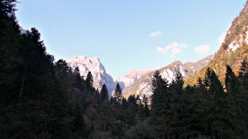
Main Dolomite
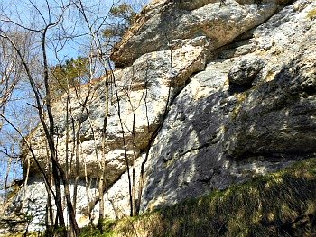
The large greyish layers encountered along the route are mainly constituted of Main Dolomite (pictured above, the Dolomite range of the Cimonega group, as it appears from the val Canzoi looking northwards). This rock presents – when freshly fractured – a coloration that goes from white to light grey; the walls that are exposed to the atmospheric agents result instead in a more or less dark grey, depending on the intensity of the alteration. This rock was formed during the Upper Trias, when a vast tidal plain occupied the area. The sea levels varied cyclically over time; in some periods, the tidal plain was completely submerged under water for a few metres (sub-tidal conditions), while at other times it would either be immersed or emerging, according to tidal oscillations (inter-tidal conditions); finally, it could be consistently emerged (supra- or super-tidal conditions).
Very often, in the Dolomite layers one can still recognize the traces of these different sedimentation processes. The separation between one layer and another – underlined by the presence of clay or breccias formed by angular fragments – is further evidence of the emerged mass. The fine laminated intervals which are present above or below the different layers, in which are also recognizable the imprints of the algal layers which colonized the plain and trapped fine carbonate mud, were deposited in inter-tidal conditions, while the massive and porous interval which contains remains of Megalodon and Worthenia was formed in conditions of total immersion. At some other times, instead, the original structures were erased after the transformation of the sediment into rocks. Dolomite rock constitutes the backbone of the Vette Feltrine chain, and it is also well visible in the lower reaches of the Val San Martino, Val di Lamen, Valle del Mis and Val Cordevole.
Flora and Vegetation
At the altitude band where most of the Val Canzoi Nature Trail is situated, one can witness a real competition between Beech and Hop Hornbeam, and the predominance of one over the other is linked either to ecological factors or to the influence of man. Beech favours fresher habitats at higher altitudes with more fertile soils, and can tolerate interventions by man which are not too drastic or too close in time (such as regular coppicing). At altitudes of 600-700 metres, on primitive and relatively arid soils typical of very steep slopes with many protruding rocks, Hop Hornbeam becomes instead dominant on Beech – especially if intense or frequent coppicing have taken place, as this species is more resilient.
The Ostryo-Fagetum
This is the botanical name of a Sub-montane wood formation composed of Beech mixed with Hop Hornbeam (Ostrya carpinifolia). It is a type of woodland which is quite widespread in the territory of the Park within the altitude band between 600 and 1,100 metres. The two main species are present in very variable proportions: Beech dominates at the most elevated altitudes or in the fresher locations, while more arid and warmer conditions favour Hop Hornbeam. The latter – given its prominent ability to produce shoots – can also easily become prevalent where cuts and coppicing have been more frequent in the past. This type of Beech wood – called by the phyto-sociologists Ostryo-Fagetum – is present from the Dinaric to the Julian Alps, and it spreads further westwards by following the southern margin of the Eastern Alps.
Pioneer Plants
The gravelly scree offers a chance to observe some of the pioneer plant species – that is, those plants that are able to colonize primitive and inhospitable open habitats. These plants are able to attach themselves to the ground quite fast, beating on time the more exigent species as for soil type. In a short stretch of the route one can distinguish, for instance, three different types of Willow – pioneer plants by definition: Salix eleagnos (the most common amongst the willows growing along the streams, with a bushy aspect); S. glabra, which colonizes detritus in warm locations, and S. appendiculata, which one can find even on more mature soils – for instance on abandoned pastures.
In the situations with a continuous supply of detritus from above, it is relatively easy to bump into species that can normally be found at more elevated altitudes, and that are being drawn towards the valley bottom by the joint action of landslide detritus and water from the streams. This is where, when crossing these small impluvia, one can notice the elegant Einsele Columbine (A. einseleana), the Sedge Carex firma and Dwarf Rhododendron (Rhodothamnus chamaecistus).
Two Small Botanical Rarities
A Dolomite outcrop met along the way conceals a couple of surprises that enrich its naturalistic value; two species which are not very showy, but nevertheless deserve attention, as they are both quite rare and vulnerable. Veselskyi Campion (Silene veselskyi) is a plant that takes its name from the Bohemian florist and mycologist F. Veselskyi; it belongs to the same family as cloves and pinks (Caryophillaceae) and it very similar to Spring Campion (S. quadridentata), from which it differs – besides for the different habitat in which it grows – for the dense and glandular hairiness on the stem and leaves. It is a plant typical of places which are not easily reached by heavy rain, and therefore we find it in niches and along rock ledges – as well as at the entrance of caves. It can be considered an endemic of the South-eastern Alps, being widespread only on the southern Alpine range from Slovenia through to Trentino and South Tyrol – and across the mountains of Veneto, as here.
The Asplenium of the Dolomites (Asplenium seelosii) is a small plant dedicated to G. Seelos, an engineer and naturalist from Bressanone/Brixen, in South Tyrol. It is a minute and curious plant; a fern with characteristic lamellar leaves reduced to only three jagged segments. It is typical of Dolomite crags particularly sheltered by the wind, at altitudes which are not too elevated. This species has a western Mediterranean distribution; it is rare and localized, being mainly found in the calcareous montane belt of the eastern Alps, and more frequently in the areas that escaped the Quaternary glaciations.
Honesty (Lunaria rediviva) is a plant about 40-100 cm tall; its leaves have a regular, serrated margin and the pale lilac flowers are scented. The fruit – known as siliqua – is progressively restricted at the extremities, and it presents a pattern which forms a sort of network. The Latin name derives precisely from the shape of the seeds, vaguely reminiscent of a full moon – or perhaps this is due to their shine. In turn, the characteristic shape of the fruit has suggested the other common name with which this plant has become known: the “Coins of the Pope”. It can be found in gorges and other humid habitats – such as shady broadleaved woodlands – at, generally speaking, quite modest altitudes (from 300 to 1,100 m). This species is quite widespread in various parts of Europe; in the Alps it has a sporadic distribution. In the Dolomiti Bellunesi it is present with fragmented stations, but with thriving populations in some areas (such as the Val di Lamen, Valle di Sant’Agapito, Val Vescovà, Valle dell’Ardo and Val dei Ross).
Charcoal Production
During the summer, in places such as the Val Canzoi, square flat areas known locally as ere or aiàl were prepared, where long pieces of timber (mostly beech and hornbeam) would be stacked up. These, called stèle, were about 1 m long, and placed all around a central chimney, thus forming a charcoal kiln (known locally as poiàt). The stack was then covered with the cut branches of Norway Spruce and earth, so to prevent air from coming in, and then the chimney would be filled with burning ashes from above, thus starting off the carbonisation process. This procedure lasted between 8 and 12 days, depending on the dimension of the charcoal kiln, and the charcoal produced as a result was taken to the valley floor either with wicker baskets, by sleigh (locally known as musse), or with zip lines.
Geo-morphology
There are, along the Val Canzoi Nature Trail, several good points where to observe small side valleys running on fault-lines, whose stream beds are structured along grossly flooded areas, while needles and pinnacles sculpted in the Dolomite rocks crown the valley heads. The development of these side valleys is strongly affected by the geologic structure; notably: 1) the valley cuts are arranged in correspondence of more eroded fractured rocks, associated with a band of parallel faults. In this sense, the series of three side valleys that are encountered in the middle section of the Val Canzoi Nature Trail can in fact be considered “fault valleys”; confirmation to this hypothesis comes from observing – on a topographic map – the unusual confluence of these three small stream beds into the main Caorame stream against the natural flow. 2) The stream beds are obstructed by pebbles, blocks and calcareous-Dolomite boulders; the grosser materials were originally uprooted from the rock substrate, then abandoned by the local glaciers (as moraine deposits) and subsequently recaptured and deposited further down the valleys by the streams during flood events, with the dynamic of “mass transportation” (mixtures with a high density of water, detritus and stones). 3) The Dolomite ridges (crests, in actual facts) that crown the head of the small valleys take the shape of needles, pinnacles and towers: these are shapes which are frequently found in the sculpted reliefs made of Main Dolomite, when Dolomite rocks – stratified into sub-horizontal layers – were affected by a dense network of vertical fractures. The processes of degradation and karstic corrosion that followed further enlarged the fractures, thus isolating the needles and pinnacles, which nowadays are considered typical forms of the Dolomites’ landscape.
The Karstic Spring
Once passed the small Val Casole stream, the Val Canzoi Nature Trail crosses a small irregular plateau, flanked by blocks and calcareous-Dolomite boulders, scattered in a chaotic way. The accumulation of detritus, with a very coarse grain, is constituted only of ‘local’ rocks: Dolomite (Main Dolomite) and Grey limestone (‘Calcari Grigi’). This chaotic deposit represents in all likelihood a ‘local moraine’, left over by a glacial tongue during the last glaciations. From the viewpoint along the path, by ascending for a few minutes along the small side valley, generally dry, one can reach the “Bus del Caoron”: this is an important karstic spring, constituted by a sharply descending conduct ending with an active siphon.
This siphon works sometimes as an intermittent spring in the occasion of heavy precipitations, and probably represents one of the main directions in the underground drainage system pertaining to the western side of the Erera-Brendol karstic plateau. Karstic springs are fed by the subterranean waters that circulate in calcareous-Dolomite massifs along a more or less evolved network of fractures, conduits and wells (hypogeal karstic network). The subterranean flow – very rapid – does not allow an effective self-depuration of the water, and this makes these springs quite vulnerable in case of pollution. The karstic network develops generally along the discontinuities which are present in the rock masses (fractures, faults, stratified layers), and results therefore strongly conditioned by the local geological structure; for this reason, very often, the basin feeding a karstic spring does not coincide with the superficial hydrographic basin, situated above it.
The Epigenetic Gorge
At one point, the Val Canzoi Nature Trail goes along the artificial basin created for hydro-electric purposes to exploit the water from the Caorame stream: the Lago della Stua. This area is optimal for observing an interesting geo-morphologic phenomenon, which took place in this area a long time ago: the formation of an epigenetic cut, newly originated after a phase of slumping of the original valley. This phenomenon can be synthesized in four phases: 1) before the last glaciations, the original valley of the Caorame stream – like a “first generation valley”, so to speak – was in all likelihood more to the hydrographic right, when compared to the actual position; 2) by the end of the last glaciations (about 12,000 years ago) the stream, through recapturing and re-mobilizing the moraine material abandoned in great quantity by the local glacier, had filled up this section of valley with significant quantities of alluvial-fluvio-glacial deposits, thus sinking the “first generation valley” (by now become a ‘sunken’ – or hidden – valley); subsequently, 3) the Caorame stream moved its new bed more to the hydrographic left and started to cut into the alluvial-fluvio-glacial deposits; 4) the stream has then continued its erosive action by carving up a gorge in the Dolomite rock, thus forming the actual outiline (technically speaking, this is called an epigenetic gorge).
In much later times, the dam for the formation of the hydro-electric basin of Stua lake (Lago della Stua) was set up right in correspondence with the epigenetic gorge. Recently, an intervention on the left side of the basin – constituted mainly of very permeable alluvial-fluvio-glacial material – made it waterproof through the injection of a concrete mix: this was deemed necessary in order to enhance the hydraulic endurance of the dam.
Another small example of epigenetic gorge – always within the setting of the val Canzoi – can be observed further south, at the valley exit, in the area of Ponte Umin.
Fauna
The area of “Bus del Caoron”, mentioned above, owes its interest primarily to the particular karstic phenomenon that takes place there, which does not detract, however, from the fact that in relation to the periodic abundance of flowing water a fresh micro-climate develops – favoured also by the presence of woodland – inside which can find shelter amphibians such as Alpine Frog (Litoria verreauxii subsp.), Common Toad (Bufo bufo) and Fire Salamander. The latter, in particular, can enliven the itinerary with its presence – especially in bad weather (for those who dare to venture!), as this little creature moves out of its usual habitat mostly on rainy days, while remaining hidden in rock fractures, holes and crevices in sunny weather.
The Fire Salamander (Salamandra salamandra) is the most common species within the genus, and it is distributed in all environments from the valley floors to the most elevated areas. As anticipated, this creature spends most of its time hidden away under the foliage, coming out of its shelter only at night – or during the day only if the humidity is high; in the adults the body is black and shiny, with yellow spots. Salamander feeds on insects, terrestrial Arthropods, mollusks and worms. Mating takes place on the ground in spring; the larvae develop in the water instead, and take on a grey or yellow-grey colour, with the precocious appearance of yellow spots. The habitats frequented by Fire Salamander during the reproductive period include springs, streams, pools and the so-called 'lame' (former drinking pools for grazing animals); winter latency goes from November to March. By observing the area along the Caorame stream, or the pools that form along the Val Canzoi Nature Trail – where water stagnates or flows slowly – it is possible to spot the larvae (and sometimes even the adults) of Fire Salamander; however, this tiny creature produces a powerful toxic liquid that is secreted by the glands on its skin, and therefore for no reason it should be touched.
Woodland Birds
Among the numerous animals present in the habitats crossed by the Val Canzoi Nature Trail birds certainly play a vital role, both in relation to their abundance and in consequence of the fact that – unlike other elusive species (micro-mammals, ungulates, Mustelidae) – birds decidedly make themselves more easily observable (or at least heard, as they betray their presence through their song). The songs are given off by the males in the course of the reproductive season (spring and autumn), with the function of marking the territory inside which each couple will build their nest and raise the chicks, while also defending the nest from possible predators; additionally, through his song, the male strengthens its bond with the female. In the woodlands along the Val Canzoi Nature Trail, starting from the end of March and all the way until the end of June – a time in which the singing activity is at its maximum – one can thus listen to the songs of many birds, amongst which are Wren, Robin (Erithacus rubecula), Blackbird (Turdus merula), Blackcap (Sylvia atricapilla), Common Chiffchaff (Phylloscopus collybita), Western Bonelli’s Warbler (Phylloscopus bonelli) and several types of Finch, amongst which is Common Chaffinch (Fringilla coelebs). There are also Jay and Nuthatch (Sitta europaea), who betray their presence with a particularly noisy song.
Facilities in the Val Canzoi: the “Casa al Frassen”.
In 2000 the Park acquired from the ULSS No. 2 in Feltre over 700 hectares of meadow, woodland and rock (‘crode’) in the Val Canzoi. The property extends from 750 m above sea level in the valley floor to the 2,547 m of the top of Sass de Mura, the highest peak in the Cimonega range. Inside the property, in one of the areas of major value from a landscape and environmental point of view, is found the “Casa al Frassen” (Frassen House), a three-story building dating back to the first half of the 20th Century. This was the highest permanent residence in the entire Val Canzoi, home to the Bastiani family (known as Frassenòt); it was later to be used as clubhouse by the employees of the Feltre hospital. After the purchase, the Park had the building renovated, and converted it into a guest house for hikers, as well as environmental education centre for students, groups and associations.
This building, like all the others built or renovated by the Park, is part of a “Fossil Free” project that envisages the exclusive use of renewable energy sources within the protected area: the electric energy necessary to keep the guest house running is produced by photovoltaic solar panels installed on the roof, while the heating system runs on a biomass boiler. The guest house sleeps up to 22 people, and it includes bathrooms, a fully equipped kitchen, a small classroom for educational activities and a spacious dining room with a fireplace. In 2012, the “Casa al Frassen” was awarded an ‘Ecolabel’ mark by the EU; this recognition is given to those facilities committed to safeguarding the environment by reducing water and energy consumption, limiting pollution, and managing waste collection correctly.
Return from val Canzoi to Dolomiti Bellunesi
Return from val Canzoi to Italy-Tours-in-Nature
Copyright © 2013 Italy-Tours-in-Nature

New! Comments
Have your say about what you just read! Leave me a comment in the box below.