- Italy Tours Home
- Italy Ethos
- Tours 2023
- Blog
- Contact Us
- Dolomites
- Top 10 Dolomites
- Veneto
- Dolomites Geology
- Dolomiti Bellunesi
- Cortina
- Cadore
- Belluno
- Cansiglio
- Carso
- Carnia
- Sauris
- Friuli
- Trentino
- Ethnographic Museums
- Monte Baldo
- South Tyrol
- Alta Pusteria
- Dobbiaco
- Emilia-Romagna
- Aosta Valley
- Cinque Terre
- Portofino
- Northern Apennines
- Southern Apennines
- Italian Botanical Gardens
- Padua Botanical Garden
- Orchids of Italy
Zoppé di Cadore and the Pelmo: a Beautiful Village and a Majestic Mountain -- a Winning Pair.
A shorth diversion from Forno di Zoldo climbs up the short Rutòrto (literally, ‘Crooked brook’) valley, and after a steep rise leads to the tiny hamlet of Zoppé di Cadore – an isolated appendix of Cadore which has historically always gravitated on the Zoldano, as it is situated beyond the Boite watershed in a small enclave known as Oltremonti (of which indeed is also part Selva di Cadore, in the upper Fiorentina valley).
Zoppé di Cadore is the least extended, least inhabited and most elevated municipality in the province of Belluno, and it is dominated by the massive dome of Monte Pelmo (3,168 m), which here crowns the skyline in all of its majestic glory.
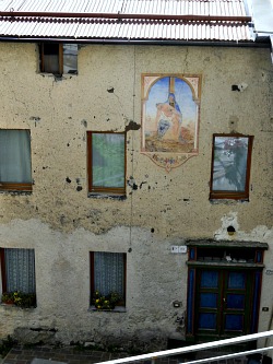
Zoppé di Cadore has many interesting examples of vernacular architecture (see an image below), plus – in the church of Sant’Anna – a beautiful painting (Madonna and Saints), allegedly attributed for many centuries to the Great Master Titian (further studies, however, seem to have ascertained that this painting is not his, but it was probably executed by a very skilled painter belonging to the Titian’s circle, perhaps Francesco Vecellio – hence the difficulty in the attribution).
History
As anticipated earlier, despite being geographically speaking part of Zoldano, Zoppé di Cadore is traditionally as well as historically considered a disjointed section of Cadore. The traffics were also oriented towards this region, as the connection through the Forcella Ciandolada (that links the village with Vodo di Cadore) was once a lot more used than it is today; besides, the more distant Passo Cibiana was in use too.
According to traditional sources, the village was founded in the 5th century, as the inhabitants of the Boite valley – afraid of the Huns invasion – left the valley floor and took to the hills. By the Colle di Fiès (1,588 m) they allegedly erected a castle of which there is no trace left – but this could as well be a legend. The first official written evidence of the existence of Zoppé di Cadore dates in fact to 1216, then again to 1357, when the area belonged to the Patriarchs of Aquileia. In 1420, Cadore became a possession of the Republic of Venice, during which the region was divided into 10 centenari or centene (smaller sub-units); Zoppé di Cadore – together with Vinigo, Peaio and Vodo – was part of the centena of Venàs. In 1896 the village was almost completely destroyed by fire.
In the locality known as Pian dal Forno some workshops were probably erected; charcoal was being produced, while minerals were taken there from Colle S. Lucia, from the Fruxile mines which later became known as Fursìl. Despite the fact that there are no formal documents, some remains were found in 1940 in the area still called today Pian da For, which seem to confirm this hypothesis: this site – located near the Rutorto stream, and in an area rich in wood – was indeed optimal for iron kilns, being situated also in the vicinity of the so-called “Vie del Ferro” (“Iron Ways”).
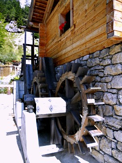
In fact, besides the church mentioned above, there are still some interesting sights in Zoppé di Cadore related precisely to its industrial history (such as a small Ethnographic Museum and a newly restored old watermill; see picture below), but the main attraction of this village, today – apart from its secluded location – is undoubtedly the rewarding treks and hikes that can be enjoyed from here.
Walks and Hikes from Zoppé di Cadore
Steep walks lead up from Zoppé di Cadore along the Pelmo slopes to Forcella Candolada (also spelt Ciandolada, 1,565 m), from where a long haul can take you all the way down to Vodo in the Boite Valley (bear in mind that this is a demanding excursion that should be undertaken by the experienced trekker only), but even if you don’t want to go all the way, several areas notable for their naturalistic value are encountered along this path, such as the ones described below.
The ‘Complex of Serla’. Together with the important peat bogs at Danta and Coltrondo in Comelico and other biotopes located near Passo Falzarego, this area can be considered part of a “multiple naturalistic system” spread over the whole mountainous section of the province of Belluno, represented by a number of sites – either peat bogs or wetlands – that develop in the vicinity of water. Here, the alternation of open spaces (meadows and sparse woodland) – variously connected by a series of small springs on slopes subject to the activity of running water – builds a landscape unit rich in vegetal species.
In the ‘Serla Naturalistic System’ peat bogs occupy flat or ‘depressed’ sites within a surface once occupied, in all likelihood, by a vast moraine deposit or ancient landslide. This is confirmed by the fact that on those same surfaces one can find humps (cumuli) of Sphagnum moss, with a notable contingent of Carex pauciflora also present in the immediately surrounding area; wetland associations with Molinia, Carex fusca and Carex rostrata are quite widespread too.
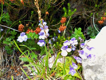
In the whole area, at different altitudes, are to be found little slopes from which small springs gush forth; in these habitats there is an abundance of Menyanthes trifoliata – an aquatic plant that becomes less and less present the further up one goes, as the water plate becomes less superficial. In spring, particularly noteworthy – especially form an aesthetic point of view – are the blossoming of several orchid species, such as for instance Dactylorhiza majalis and Bartsia sp., while other plants typical of wetlands – such as Primula farinosa and Pinguicula vulgaris – are also present.
In the more shady locations – but also elsewhere – one can observe two other main vegetal communities: the mixed formations with Dwarf Mountain pine and Sphagnum moss and the purer ‘carpets’ of Sphagnum magellanicum (below, an image of the lilac form of Pinguicula vulgaris, a typical wetland plant).
The most common types of Sphagnum moss – those more capable of creating the characteristic humps – are S. fuscum and S. capillifolium, besides the already mentioned S. magellanicum. Towards the barns (characteristic wooden building locally known as ‘tabià’) in Fiés there is an extensive colony of Equisetum, which comprises the much less common species E. fluviatile; along the way, also, is to be signaled the presence of communities of Carex elata and – especially above the path – of C. paniculata. Almost invariably, those damp or wet habitats are screened by sparse larch formations whose understory is rich in tall herbs that indicate the re-colonization of old meadows after the abandonment of scything practices. Here some notable species can sometimes be found, such as a tiny carnivorous plant: Drosera rotundifolia.
The Drosera (Common Sundew) is a herbaceous plant about 10-15 cm. tall, with obovate leaves disposed as in a basal rosette; on the upper side of the leaf they display some purplish hair that exude a viscous liquid, which contributes to trap insects of small dimensions. When the hair come into contact with the Arthropods, they fold upon the victim, holding it firmly. This species blossoms from April to September, producing tiny white or yellowish flowers. Once this plant was widespread in Italy, while today it is quite rare, and it can be found occasionally on the Alpine and Pre-Alpine range, in humid/damp locations such as fields, meadows and peat bogs, and also on those pastures which retain stagnating water.
As for continuing the excursion, there are at this point two main alternatives: proceeding towards Vodo, one will eventually encounter – by a quiet meadow which is rarely too busy – the secluded Rifugio Talamini (1,582 m); in fact, up to this point, the route coming from Zoppé di Cadore is relatively flat, and the excursion could well terminate here, before the descent towards Vodo begins. Alternatively, the other option is to take one of the paths towards Rifugio Venezia: a busier route altogether, but a trek that would certainly reap its rewards (described below).
At first, always continuing along the road for Col Botei, one passes (this time below the path) another wetland station which does not substantially differ from the preceding ones (and the many others present in the area), while of noteworthy naturalistic value – as the peat bogs are in a further phase of dessiccation – is the vast wetland area in the vicinity of Tabià Tamaril (around 1,750 m): situated along the busy tourist route to Rifugio Venezia (for which, see below), this area is affected both by the trampling of walkers as well as by being still actively used for animal grazing; the woodland formations that surround the peat bogs are therefore quite sparse, signaling the historic coexistence of livestock farming on meadows that were once regularly scythed.
Climbing up in altitude, one then encounters extensive Dwarf Mountain pine formations: often these plants give origin to contorted ramifications which penetrate deep into the fractures, and attach themselves on to ledges, becoming one with the supporting rocks. On the large calcareous boulders, the ramifications and the dark green of the prostrate canopies of Dwarf Mountain pine stand out against the candor of limestone, thus providing one of the essential images of Dolomite landscape.
The Excursion to Rifugio Venezia
The Rifugio Venezia - Alba Maria de Luca is situated in the municipality of Vodo di Cadore, between the Zoldano and the Boite Valley, at an altitude of 1,947 m at the foot of Pelmo. It is an historic building of Cadore, as it was erected in 1892, and it was the first Italian Mountain hut to have been built in the Dolomites (much of the area at the time was still Austrian). Set on fire during WW2, it was rebuilt afterwards, and inaugurated in 1950.
From the hut, the sights open widely on a vast portion of the Dolomites including Monte Cristallo, the Croda Marcora (Sorapiss group) and the Antelao – ‘King of the Dolomites’; also, by the hut pass the ‘Alte vie’ (‘Alpine Highways’) Nos. 1 and 3.
There are several accesses to Rifugio Venezia. On the Zoldano side, for instance, one can ascend from Passo Staulanza (CAI path marked 472), Palafavera (CAI paths 474 and 472) and Coi di Zoldo Alto (CAI paths 473 and 472), but the main access is usually from the trail connecting Zoppe di Cadore with Vodo. From Zoppé di Cadore, one can take CAI path 471, or alternatively the more direct (but steeper) route marked CAI 419.
In this context, I will also describe the routes to the Venezia mountain hut from Borca and Vodo di Cadore, as these are often the most common accesses – if anything, because these locations are easier to reach by car and public transport.
From Vodo di Cadore one can take the partially tarred road to Malga Ciáuta, from which – via the CAI path 475 – the hut is reached in about 1h30; otherwise, another partially tarred road takes to Rif. Talamini (see above); then from there follow the directions to Zoppe di Cadore towards F.lla Ciandolada (1,565 m; also described above), until a fork where one needs to branch off towards Rifugio Venezia; from this point, one can follow the track 493 and then 471 to reach the hut in about 1h30.
From Borca di Cadore, instead, starting in the borough of Villanova, one can follow partly the untarred road to the locality of Tiera (1,271 m), where there is ample parking; from there, with CAI path 470 through the Piani de Madiér, one can reach the hut in 2h30. Bear in mind that, for the facility to park, this is one of the most frequented accesses – and therefore not the best option if you’re looking for the quietest path. But – equally from Borca – there is also a longer and less frequented route (if you are based in this village, the two trails together can make for a good roundtrip). The starting point is always in the borough of Villanova, from where one follows CAI path marked 475 to Malga Ciáuta (1,552 m), from which a mule track ascends along the small side valley of Ru de Ássola across the splendid sceneries of Pian de la Palù (1,700 m) and Cianpe de Naiarón, to eventually reach the hut in about 3h30.
Finally, Rifugio Venezia can also be accessed from San Vito di Cadore: here, from the borough of Serdes, one follows the indications to the hut until joining the road coming from Borca that leads to the locality of Tiera (described above); the route is then the same.
For more information on the villages of Vodo, Borca and San Vito di Cadore, refer also to the Boite Valley page.
Return from Zoppe di Cadore to Zoldano
Return from Zoppe di Cadore to Italy-Tours-in-Nature

New! Comments
Have your say about what you just read! Leave me a comment in the box below.