- Italy Tours Home
- Italy Ethos
- Tours 2023
- Blog
- Contact Us
- Dolomites
- Top 10 Dolomites
- Veneto
- Dolomites Geology
- Dolomiti Bellunesi
- Cortina
- Cadore
- Belluno
- Cansiglio
- Carso
- Carnia
- Sauris
- Friuli
- Trentino
- Ethnographic Museums
- Monte Baldo
- South Tyrol
- Alta Pusteria
- Dobbiaco
- Emilia-Romagna
- Aosta Valley
- Cinque Terre
- Portofino
- Northern Apennines
- Southern Apennines
- Italian Botanical Gardens
- Padua Botanical Garden
- Orchids of Italy
Alpago, a Natural Microcosm between Lake, Forests and the First Ramparts of the Dolomites.
The Natural Setting
The sub-region of Alpago is a vast, enclosed natural basin opening to the north of the low Fadalto pass, and crossed by the wide valley of the river Tesa.
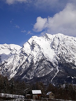
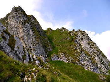
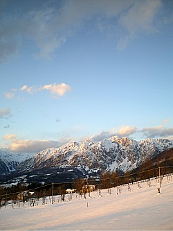
It is surrounded on all sides by hills or mountains. The area is separated from the neighbouring Dolomiti Friulane by a majestic curtain of mountains – a long sequence of peaks closing the region to the north-east, comprising Monte Cavallo (2,250 m) and Teverone (2,345 m). This natural curtain culminates at Col Nudo (2,472 m; see image above), which offers one of the widest views in the Pre-Alps of Belluno (Prealpi Bellunesi).
Looking north-west, the landscape is dominated by the long, distant sight of the jagged peaks of the Dolomiti Bellunesi, while in the foreground stands the ridge of medium-height, rounded mountains separating the Piave valley (Val Belluna) from the Venetian plain, and culminating at Col Visentìn (1,763 m).
Perhaps, though, Alpago’s main feature is the wide Lago di Santa Croce (literally translating as “Holy Cross Lake”), lying right at the centre of the region and visible from almost anywhere.
It is the only natural expanse of water of a certain relevance in the whole province of Belluno, created by a tectonic fault at the time of the last glaciations.
With an extension of 750 ha, it is also the second biggest lake of the Veneto region, after Lake Garda.
In fact, so important is this lake that it has given its name to the region, as Alpago derives from Lapacum (= lake), later corrupted in Lapacinus, while the glacial valley giving access to the region from the south is still known today as Valle Lapisina.
The Five Municipalities of Alpago: Farra d’Alpago
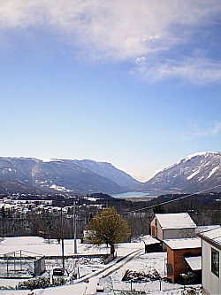
Along the shores of the lake lies Farra d’Alpago, one of the five municipalities that form Alpago (below, an overview of the region, with Lago di Santa Croce and the Valle Lapisina in the distance).
The other four municipalities are Pieve d’Alpago, Puòs d’Alpago, Chiès d’Alpago and Tambre d’Alpago. These are described in more detail below.
Let’s now see briefly what the main points of interest are in each town, starting with Farra d’Alpago, which is one of the two low-lying communities, and has developed very much in symbiosis with the lake, which is extensively used today for water sports during the summer months (especially surfing and sailing).
This is because the Lago di Santa Croce is renowned for its breezes, which generally pick up in the afternoon, channelled through the narrow gorge of the Valle Lapisina: this is like an open canyon separating Alpago from the Venetian plains (now dramatically cut across by the dual lanes of a motorway), which acts like a natural funnel for the wind.
In Farra there is also a pleasant sandy beach, particularly favoured by families, while a cycle path runs along the eastern shore to the hamlet of Poiatte, where there are a boating club and other water sports facilities.
Other notable spots along the lake include the Baia delle Sirene (the Siren’s Bay) – a secluded little cove to the south of town – and a Nature reserve, which is reached by heading in the opposite direction from the main beach (to the right when watching the lake; read below).
The centre of Farra itself offers some motives of interest as well, especially as the main church displays a sorrowful Crucifixion from the renowned Bellunese sculptor Antonio Brustolon (1662-1732), while scattered in the alleyways are some examples of vernacular architecture.
This area, geographically speaking, belongs to the Prealpi Bellunesi (Belluno Pre-Alps), and that is reflected in the traditional architecture, which makes a more abundant use of stone as opposed to wood.
The wooden buildings of nearby Cansiglio are in fact an exception, but there are good reasons for that (see the relevant page).
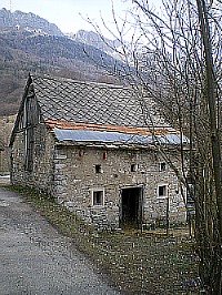
Below, is pictured an example of a traditional building of Alpago, with the characteristic cover of slate tiles (in the most ancient examples – now very rarely seen – there are also thatched roofs made of hay and reeds from the lake).
The Five Municipalities of Alpago: Pieve d’Alpago
Three of the other four municipalities that form Alpago are, to a different extent, mountainous.
Pieve d'Alpago is historically the main centre, the name suggesting that – as in Cadore – its church was once the “mother church” of the region, exercising some degree of coordination and control over the others.
Being the closest to Belluno, though, Pieve is also the most inhabited and industrialized centre of the five.
This is the case of Puòs d’Alpago too, which is low-lying and more or less half way between Pieve and Farra d’Alpago, and offers perhaps a bit less in the way of natural and cultural attractions.
This is true only up to a point for Pieve d’Alpago, however: in the centre of town there is villa Falin, which – albeit in not a very good state of conservation – is the only Venetian villa within the area, while some of the small hamlets belonging to the municipality of Pieve do display some interesting examples of traditional architecture too.
This is the case, for instance, of Plòis and Curago; in the former hamlet, the little church contains a wooden Crucifixion attributed to Andrea Brustolon, while the latter conceals some houses dating to the 15th/16th century.
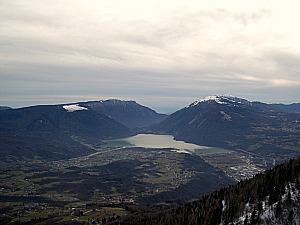
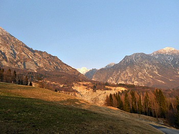
Also, a short distance from Pieve starts the ascent to Monte Dolada (1,938 m), which opens up like a natural balcony commanding sweeping views over the whole region, with the basin of Lago di Santa Croce that sits right in the middle (pictured below, the Lago di Santa Croce as seen from the summit of Monte Dolada).
More than for its panoramas, though, this mountain is now known far and wide as one of the best natural platforms in the Dolomites for gliding, parachuting and other sports that rely on the wind.
This is made possible by the nature of the place, as Monte Dolada is an isolated peak situated at the junction between Alpago and the underlying Piave valley, which bends right under the mountain, taking a more northerly direction after the open section of the Val Belluna, oriented SW/NE.
This exposed geographical location is responsible for the strong thermal currents that rise here, as the dominant south-westerly winds impact against the mountainside.
This means that, especially in the summer months, people travel long distances to come and launch from Monte Dolada, and important competitions – at European level – are held here.
The open meadow where the launching platform and the mountain hut are situated (Rifugio Dolada, 1,492 m) is the starting point of the paths that lead towards the summit of Monte Dolada itself – an area notable for its flora too.
Monte Dolada can also be reached via paths from the relatively low-lying Rifugio Carota (1,002 m): an intermediate viewpoint along the mountain slope, which offers several options for the ascent, if you prefer to walk (it can also be arranged as a circular route that takes about 3-4 hours to complete).
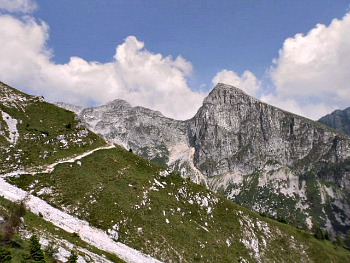
Once at the top, a solitary ridge walk towards Col Mat offers eventually broad views on the other side too, towards Erto – and beyond on the Vajont valley – allowing also one to descend into the wild Val Gallina (see below an image of the contorted rocks encountered along the path towards Col Mat).
Further on, this sweeping panorama is closed like a curtain by the highest peaks of the Dolomites, such as the Antelao, Pelmo and Sorapiss; even the distant Marmolada with its glacier – at 3,342 m the “Queen of the Dolomites” – is visible from here on a clear day.
The Five Municipalities of Alpago: Chiès d’Alpago
Chiès d’Alpago is a medium-altitude village with interesting stone houses built in the characteristic style of the Pre-Alps; the same goes for the small hamlets of Funès, Irrighe and San Martino, as well as for the more isolated buildings that can be seen along the little-frequented road connecting Chiès d’Alpago to Tambre d’Alpago.
After an initial climb, this road runs almost level at an altitude of around 1,000 metres, following the contour of the mountains that close the Alpago basin to the north like a curtain, and whose rock faces fall almost sheer a short distance away.
No surprise, then, that some of the most interesting paths leading in altitude (such as into the beautifully wild Val Salàtis; read below) can be taken from here.
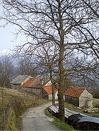
This whole section of Alpago is very little inhabited, and peppered with old traditional stone buildings (mostly temporary stables), some of them now converted into homes or farms that at times also offer accommodation (see picture below), and very ancient trees – such as the multi-centenary beeches at Piàn Formosa.
The road connecting Chiès to Tambre may be closed in winter due to high snow – and it goes without saying that, in such cases, the paths become inaccessible too, as the area is prone to avalanches.
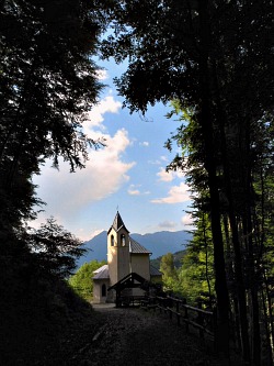
Chiès d’Alpago also hosts a small but interesting Museum of Natural History, while along the road connecting Chiès to Puòs is the isolated hill on top of which stands the solitary church of San Pietro.
This is a beautiful spot, from which to admire a serene view over all the Alpago basin; almost certainly, the church was erected on a site of former Pagan worship.
From Chiès d’Alpago you can also reach Pieve d’Alpago via a series of country lanes that follow the contour of the craggy curtain of mountains to the north. Two deep gorges (called venal in the local patois) enter the mountainsides and are the starting points for treks in altitude (it is not rare to spot eagles there), while if you keep going level along the mountain side you will eventually reach Rifugio Carota, at the base of Monte Dolada (see above).
The Five Municipalities of Alpago: Tambre d’Alpago
As anticipated earlier, at the other end of the high-altitude road coming from Chiès d’Alpago one reaches Tambre d’Alpago, which – being the highest community of the five – is also the one most geared towards tourism.
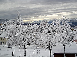
The centre of Tambre is pretty nondescript, but its territory undoubtedly offers a lot in terms of nature and walks (below, a winter view of Tambre).
The most interesting trek is probably the one leading in altitude to Rifugio Seménza (2,020 m), which can be accessed either from the Val Salàtis (read below), or from Col Indes – a panoramic area of open pastures and patches of woodland that lies at the fringes of the historic Cansiglio forest.
The presence of columnar specimens of fir and spruce is a clear indication of that proximity.
The hike to Rifugio Seménza shows a microcosm of most vegetation bands that can be found in the area, from broadleaved woodland dominated by beech to conifer woodland.
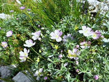
Then – past the tree line – one comes to the meadows and sparse rocky habitats where the most interesting flowers can be admired, such as Silvery Cranesbill (Geranium argenteum; see picture below), which is a rare plant whose presence can be detected along the path, together with more common – but still beautiful – mountain species.
The highest section of the path is like an open-air Alpine botanical garden; the many species represented include the emblematic Edelweiss (Leontopodium alpinum), the yellow-flowered Potentilla alpina, the blue hanging spikes of Paederota bonarota, the pink-flowered cushions of Androsace appennina and the purple-flowered fang-shaped flowers of Devil’s Claw (Physoplexis comosa).
The ascent to Rifugio Seménza can also be broken into two parts, with an intermediate stop at the Sassòn della Madonnina (“Madonna's Rock”, at 1,645 m), with open views (see below for a more comprehensive description of this hike).
The National road from Tambre d’Alpago is probably the main gateway to Cansiglio and its forest, which begins after the small resort of Spert – but there are also other, minor roads that lead into Cansiglio.
One of these is the seasonal track from Col Indes, past the centenary beech at Sant’Anna (see below) to Pian Canaie, where the ruins of an historic Cimbrian village are situated.
As a note of curiosity, in Col Indes one can also admire the so-called “Casa del Libro” (the Book House), an actual house erected in 1990 by sculptor Livio de Marchi. Completely built in wood, all parts of this house reproduce books: the walls mimic piles of closed books; the roof is like an open book laid on top of the walls, and even the fences are gigantic pencils pointing upwards!
Lakeside Farra has also part of its territory reaching up into the mountains of this section of Alpago, crossed in altitude by the “Alta Via” (Alpine Highway) No.6 (so-called “dei Silenzi” – “of silences”), connecting Sappada with Vittorio Veneto, and No. 7 – dedicated to the Austrian mountaineer Lothar Patèra – that runs within Alpago for its entire length.
In the vicinity of Spert, some paths rise towards the isolated chapel of Madonna del Runàl – a small religious building situated at one of the historical entries to the Cansiglio forest (see picture below). Now decidedly off the beaten track, this peaceful location was once very important, as near here passed in ancient times the main thoroughfare along which timber was taken downhill from the forest to the Piave, then floated on towards Venice.
The ascent to Malga Mezzomiglio – an open pasture area with some very old beech specimens – also offers an interesting alternative way to access the Cansiglio plateau, via a path from the top rather than the road.
Lower down, the village of Valdenoghér (which literally translates, in the local patois, as “Valley of the Walnuts”) offers instead a most peculiar visit in the “Casa dell’Alchimista” – the Alchemist’s House.
The Alchemist’s House in Valdenoghér
From the outside, this little building may look like any typical example of Gothic architecture of the kind erected in the area during the long period of Venetian domination – and in a way it is, but on top of that, it also has an additional layer of meaning not so clearly and obviously detectable from the immediate outside.
The Alchemist’s House was carefully and lovingly restored in the 1980s, and now it hosts a museum dedicated to alchemy, but in order to be infused by the magic of the place, one has to enter the house and take time (bearing in mind that opening times are very restricted and seasonal – summer only).
This dwelling is steeped in mystery, as it was probably erected by an alchemist fleeing Venice in the 16th century; its layout – as well as the complex symbolism of the sculptures – is loaded with references to this most mysterious of activities, which literally consisted of trying to turn lead into gold (but the whole process can be interpreted symbolically on so many other levels, and the reading material displayed in the house-museum offers enlightening explanations in that regard).
It is an eerie yet very interesting, unusual visit, which puts one in touch with an aspect of cultural history not so well known, but that was very important at the time.
Alpago Nature Trails
With the support of the local authorities, a project has been set up to promote awareness of both the Museum of Natural History in Chiès d’Alpago and Alpago as a whole. The intention behind this project is to connect the territory with the information available in the Museum; with this idea in mind, five thematic trails have been devised, connected to themes presented in the Museum – that is, ‘Learning trails’ (Please note: as of summer 2012 the Museum is closed for refurbishment until further notice, but the trails all remain available).
These trails were chosen to show visitors characteristic aspects of the region, especially in regards to nature, history and traditions. These trails, which will be briefly described below, are:
1) The Wetlands Nature Trail;
2) The Tessina Landslip Geo-morphological Trail;
3) Sant’Antonio Tiriton Forest Trail;
4) The Archaeological Trail in Pieve d’Alpago;
5) The Malga Cate and Val Salatis Nature and History Trail.
The Wetlands Nature Trail
This Nature Trail – in the municipality of Farra d’Alpago – deals with three main habitats: water, woodland and reed beds. Many fish species enact their entire life cycle in the waters of Lago di Santa Croce. Among these, here can be found Perch (Perca fluvialis), Whitefish (Coregonus lavarellus) and a native species locally known as ‘Sampierolo’ (Leuciscus lapacinus).
The waters of this lake are also the best site in the province for sweet water shellfish, and round its edges more than 20 species of gasteropods, bivalves and living mollusks have been counted; the most notable of these are Anodonta anatine and Unio mancus.
With some seasonal variation, the lake also gives sustenance to many birds, amongst which are Great Crested Grebe (Podiceps cristatus) and Black Kite (Milvus migrans). Let’s now give a look at the other two habitats.
Woodland. Within the protected area between the mouth of the river Tesa and the Old Tesa course, sometimes flooded by the rising water of the lake, the following tree species can be found: White willow (Salix alba), Common ash (Fraxinus excelsior) and Common alder (Alnus glutinosa); bushes include Guelder rose (Viburnum opulus), Dogrose (Rosa canina) and others.
On the trunk of these trees, bracket fungi typical of humid areas and wetlands can also be seen throughout the year.
The woodland is an ideal habitat for many bird species too, such as Great tit (Parus major), Great Spotted Woodpecker (Picoides major), Chiff-chaff (Phylloscopus collybita) and Blackcap (Sylvia atricapilla).
The woods also offer refuge to some mammals – including Badger (Meles meles), whose traces can often be seen along the paths.
The Reed Beds. Reed beds form a delicate, constantly shifting habitat, stretching in patches between the two river mouths of the Tesa and the Old Tesa, with marsh reed (Phragmites australis) as dominant species.
In the water there are many kinds of algae, the most common belonging to two groups, Diatomeae and Cloroficeae. Their presence in the lake is seasonal, and it depends very much on water levels.
During the summer months the song of Reed Warbler (Acrocephalus scirpaceus) can often be heard, as some pairs nest in the reed beds.
Insects of the reed beds include the beetle Donacia vulgaris, whose larvae develop in the reeds’ stalks. In wetter areas, reptiles like the Collared Snake (Natrix natrix) and amphibians like the Tree Frog (Hyla arborea) may be found.
The Tessina Landslip Geo-morphological Trail
This circular trail – in the municipality of Chiès d’Alpago – passes round the area affected by a huge landslip which began its movement in November 1960, when about 1 million cubic metres of material started to slide down.
The southern slope of Monte Teverone is made up of Cretaceous limestone belonging to the Fadalto formation – a highly permeable rock due to its cracks and karstic nature. This rock dips steeply to the south, where a fault line brings it into contact with impermeable Tertiary rocks, covered almost completely by a layer of calcareous rubble.
The underground water runs southwards as far as the main edge of the landslide, where it wells up with several springs. Here the Eocene Flysch surfaces too, highly folded and fractured, having been squeezed between two faults. Geological features of this kind ensure that the landslide is in continuous movement, even if not at a constant rate.
The movement of the landslip was most noticeable at its beginning – especially between 1962 and ‘63, when the gap created in the mountain side reached 500 meters in width and the mudflow 60 metres in depth. Further smaller movements were recorded up until 1992; now the landslide is basically – albeit most likely only temporarily – still.
The last meaningful movement dates to spring 1992, when about 500,000 cubic metres of material started to slide down on the left side of the valley, extending the mudflow towards the village of Lamosano, and getting dangerously near the hamlet of Funes.
To reduce the quantity of water which affected the area, a 1,300 metres long drainage tunnel was dug inside the layer of Fadalto limestone; a further series of slightly inclined channels then crossed the slope of Monte Teverone, increasing its draining capacity: this operation was completed only in 1996.
The flow of water collected with this system averages at present 150 l/sec, and it is used mainly for supplying water locally.
Distortions caused to the landscape, damage made to the vegetation and its subsequent adaptations (bent trees, pioneer plants – such as birches – growing on the exposed sections) can all be detected along the trail; as such, this itinerary is interesting not just for geologic reasons, but also in order to get an insight on how different habitats have responded to such an upheaval.
Farming activities were heavily disrupted by the landslide too, with meadows, pastures and several sheep-pens that were abandoned for years. Now an embankment near the hamlet of Funes has at least partly deviated the mudflow, thus making the area safe enough again for human activities to make a timid comeback.
This easy circular trail is best taken from the hamlet of Funes, where there are still some interesting examples of vernacular architecture to be seen; a steep rise will then take to the head of the landslip, from which one takes left following the indications to Casera Crosetta.
The track proceeds level along the mountainside, offering impressive views on the landslide from above, and then it finally descends to the hamlet of San Martino, from which a country road crosses the bottom edge of the landslip and leads back to Funes after 3-4 hours of walking (see an overview of the landslide below).
Sant’Antonio Tiriton Forest Trail
The Cansiglio forest covers about 5,000 hectares, and is currently managed by the State Forestry Commission through its Regional administration agency, ‘Veneto Agricoltura’ (of which you may see the signs when walking in the area). This trail is mostly in the municipalities of Tambre and Farra d’Alpago.
This historic forest is situated on a karstic (limestone) plateau with a characteristic open basin shape, lending itself to the phenomenon of temperature inversion, which influences the type of vegetation found there: in fact, the meadows in the lower parts are surrounded by bands of conifer usually found at higher altitudes, while beech woods (encountered at normally lower levels) dominate the hilltops.
Although there is a specific page dedicated to the Cansiglio, this trail is being described here for completeness, as it is an integral part of the five thematic trails listed above.
The forest trail at Sant’Antonio Tiriton is circular; it starts in the vicinity of the Cimbrian village at Pian Osteria and passes through the northern fringe of Cansiglio. A mixed woodland of beech, Silver fir and Norway spruce offers diversified ecosystems, where the most interesting ecological dynamics in terms of biodiversity (fauna, mosses, lichens and fungi) in the Alpago-Cansiglio area can be observed.
Here, the many layers of vegetation, trees of different sizes, large number of botanical species, stumps covered with moss and several other creatures all combine to produce a precious natural habitat, well suited to sustain various forms of animal and plant life – organisms that are part of a complex food web and contribute to enrich the biodiversity of the forest.
The snail population of Cansiglio includes mollusks and gastropods (snails and slugs) and forms an important – even if less visible – part of various forest micro-habitats (tree trunks, stumps, forest litter) in the Alpago-Cansiglio area. Along the trail you may see Helix pomatia, since it is quite common and easily distinguishable for its large shell.
Lichens, originating from the symbiotic union of algae and fungi, are easily visible on rocks, bark and from hanging branches too. They are good indicators of air quality and general health of the ecosystem, and find their ideal habitat in mixed, mature woodlands with a high degree of humidity.
Fungi are present in many forms too, emerging from tree trunks, stumps and rotting wood; they also play an important role in a forest ecosystem, being very useful at breaking down organic matter.
As hunting has long been banned, the area offers a natural refuge to most animals commonly found in this part of the Alps. The easiest mammals to spot here are roe and red deer, which are quite numerous in the Cansiglio forest. Many dusk and night time animals thrive thanks to the extensive tree cover; mice and small mammals are prey of both night- and day-time raptors. Grouse (Tetraonideae family) is also present, though the famous Capercaillie is rare.
In the Museum of Natural History in Chies you can also see various
examples of medicinal plants, explanations on the distribution of plant
species by altitude, the different vegetation bands as expressed by the
collection of wood samples, as well as many of the animals whose traces can
sometimes be spotted along the trails (for more on plants in the area, check also the Cansiglio Botanic Garden page, with which the Museum cooperates).
The Archaeological Trail in Pieve d’Alpago
The two necropolis at Pieve d’Alpago are located along an archaeological trail that starts just outside town; both archaeological sites are situated at about 1,000 metres above sea level and can only be reached on foot. The extraordinary discovery of the two necropolis near Pieve d’Alpago confirms the presence of people during the Iron Age and in Roman times.
Quite unexpectedly for the area, the finds seem to point to a prosperous standard of living. In the Iron Age site, a truncated conical situla (urn) made of bronze, decorated and dating to the 5th century BC, was found. This discovery made this burial place of great importance, comparable to the site where the ‘Benvenuti’ situla was found in Este.
The first finds were recovered in 1993 at Staol near Curago, and included a glass jar, bronze situlas, rings, bracelets and several coins coming from three different tombs; in 2000 a scientific dig began, supervised by an archaeologist. This dig has not yet been completed, as it is active only during the summer months.
So far, 84 sqm of turf have been removed to reveal a tomb with a terracotta bowl and related grave goods, including several coins dating from different periods between the 1st and 4th century AD; many bronze studs, blue glass beads from a necklace, fragments from a glass balsam jar, a bronze ring and a bracelet were also found.
The dig and the scientific analysis on the site still continue, and new discoveries are expected; the materials already found have been returned to the Natural History Museum, and are displayed there in a specially dedicated room. Previous archaeological research in the area had already produced prehistoric remains from Cansiglio (exhibited in the Museo dei Cimbri there); other Roman remains came from another site in Pieve d’Alpago while early Medieval finds came from Farra d’Alpago.
The Malga Cate-Val Salatis Nature and History Trail
The Val Salatis is a short Alpine valley extending in an east to west direction, between the peaks of Monte Messer and Sestier to the north and the slopes of Monte Guslon to the south; it displays a geological matrix of Cretaceous limestone and presents two opposing, quite distinct sides. This solitary valley is located at the border between the municipalities of Tambre and Chiès d’Alpago.
The sunny south-facing slope is characterized by screes colonized by Dwarf Mountain pine (Pinus mugo), together with isolated specimens of larch and Norway spruce, as well as a variety of herbaceous plants belonging to the Seslerietum-semperviretum association and – at a higher level – Caricetum firmae.
The north-facing slope, being colder and damper, has a more evolved subsoil, dominated by larch (Larix decidua), with some spruce (Picea excelsa) and an undergrowth of blueberries (Vaccinium myrtillus), Rhododendron (R. hirsutum) and Juniper (Juniperus vulgaris).
The valley floor, grazed by sheep for centuries, has pastures dominated mostly by Nard (Nardus stricta) and the Poaetum alpinae association of grasses (with Poa alpina as a leading species).
In this environment, some typically Alpine fauna – such as Eagles, Goshawks, Chamois and Marmot – can be spotted.
There are two trails leaving from Malga Cate and going into the Val Salatis; it was in these – long disused – summer pastures that the local breed of sheep (known as ‘Alpagota’) was reintroduced and saved from extinction.
The first Nature trail was intended to improve environmental awareness of the scree habitats near Casera Cate, and it crosses lands managed in a Co-operative form by families from three local villages. It climbs through a type of beech wood that colonizes abandoned pastures, which is presently coppiced to produce firewood. On the higher parts of the trail, the woodland degenerates into pioneer formations of Dwarf Mountain pine (Pinus mugo) and larch (Larix decidua).
The second Nature trail leads instead along the Val Salatis through land which is also managed Co-operatively by local families, and is noteworthy for its traces of human settlements – such as examples of rural architecture – and for the natural aspect of its coppiced beech woods.
Leaving from Casera Cate, one comes to the remains of Casera Astor – an egg-shaped sheep-pen where animals used to be herded for milking and shearing; further on there is a lime-kiln – a circular structure of square stone blocks where quick-lime was once made.
After this, on the right, one encounters the so-called Campitello barn – a
seasonal shelter for grazing animals, also with an old sheep-pen. At the end of
the trail – and at the upper limit of the pasture – one finally comes to the
barn of Pian de le Stele, which is now used as shelter by stranded
walkers and hikers. From this location, paths continue further up in altitude towards Rifugio
Seménza (described below), while the return route for the thematic trail uses the same road.
Veteran Trees of Alpago
Thanks to its environmental diversity and micro-climates, the region of Alpago displays a considerable variety of tree species.
This territory clearly falls into two distinct parts: the Cansiglio plateau with its forest – vast in extension, but relatively poor in species, and with not so many large trees – and the more open slopes composing the natural amphitheatre of Alpago itself, with less tree cover but greater variety.
As far as Cansiglio is concerned, to walk around Pian Rosada or Campon and to discover its trees and their stories is to imagine the old firs and beeches once known by the ancestors, who often populated the forest with the characters of ancient legends.
But even there – in the thick of the woods – there are individual ‘champions’ to be found: trees stirring the popular imagination more than others for their sheer size and their often solitary location.
The ancient beech at Sant’Anna, for example, has somehow become home to the legend of the Madonna del Runal (see above); however, the most precious tree in Cansiglio must be a wild pear (Pyrus pyraster) in Valmenera – a typically Mediterranean species which, here, was able to exceptionally withstand the climate of one of the coldest spots in Italy for hundreds of years.
Moving over to the Alpago basin now, over thirty different species of veteran trees have been identified there, and about a dozen significant areas of woodland – but more often than not the ‘champion trees’ are individual specimens.
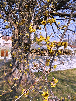
Some of these trees are quite exceptional: the Cornelian cherry (Cornus mas) at Torres (near Pieve d’Alpago) has no matches recorded in Italy (see picture below); the beech above Pian Formosa is also a majestic specimen, but a much less rare sight.
In some cases, bushes have exceptionally managed to become trees too – perhaps thanks to the mild but oceaninc (rainy) climate of Alpago; amongst these, a mounmental Elder (Sambucus nigra) at Funes, a Hawthorn (Crataegus monogyna) at Coste near Farra d’Alpago, a stately Alder (Alnus glutinosa) at Funes and finally a couple of Box trees in Chiès d’Alpago.
These trees are important not only for their size, but also for their historical relevance, and they have been subdivided into various categories: ancient specimens, which witnessed the passing of time; old fruit trees, and other trees worth mentioning and deserving protection.
The list of these trees can be consulted in a dedicated publication, and mention of them is made also in the Museum of Natural History at Chiès d’Alpago, where there is a well-stocked collection of wood specimens (a wooden cross-section of several species), which enables us to recognize the different species just from their wood. A cross-section of a larch also shows us how to read the rings of growth in a tree.
The wealth and biodiversity in the tree population of Alpago is also demonstrated by the variety of ancient fruit tree cultivars – these are bearers of an often lost traditional knowledge, kept alive uniquely by old varieties of apples, pears, vines and cherries that would otherwise be disappearing from gardens and orchards.
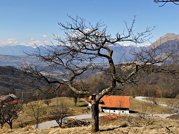
Among these varieties, worth mentioning is certainly the ancient cultivar known as Prussian apple (“Pom Prussian” in the local patois), which can be still admired in isolated specimens in the Val Turcana and around Lavina (both in Tambre d’Alpago), and the poetically named Water apple (“Pom dell’Acqua”) – which still grows at Chies and Codenzano; the “Pom della Rosetta” (Rose apple) is registered instead at Villanova near Farra (in the picture below, see an image of the Val Turcana, which is the area of Alpago with the highest concentration of ancient cultivars).
Equally worth mentioning are the pear cultivars – some giving fruits of exceptional quality – that are also growing scattered all over the territory, and which are often particularly prolific; among them is the so-called Sword pear (“Per spatha”, for the typical shape of the fruits), found at Cesarine, and St. Anne’s pear, growing near Spert and elsewhere.
Unfortunately, a register of these old varieties is still missing at provincial level; nonetheless, a research and cataloguing effort has been carried out by the Dolomiti Bellunesi National Park, and the results can be admired in several locations, although these are all outside Alpago (above all, the two trial fields at Sovramonte and Feltre), while written and photographic documentation is available and on display at the Ethnographic Museum of Serravella, in Cesiomaggiore.
In any event, getting to know these trees is to engage with a living drama inscribed in the landscape, where each tree has historically played a part in the scene, and to understand the interplay between natural and human activities that is the hallmark of Alpago. Use of the land is not always necessarily a sign of exploitation but rather – when carried out with wisdom (today we would say sustainably) – it can even enrich the biodiversity of a given area (not to mention, of course, the ethnographic and anthropological implications).
In the closing image below, a beautiful winter view from Col Indes, Tambre, with the mountains of Alpago in the distance.
Monte Cavallo and the Ascent to Rifugio Seménza
Climate. Situated between the plains and the inner Alpine chain, the area comprised between Alpago, Cansiglio and Monte Cavallo presents an intermediate type of climate between the Alpine continental and the Sub-Mediterranean. Winters are generally short and rigid, while long and fresh are the summers, and on the whole the annual excursion of temperatures is quite accentuated; also, there is often quite a range between day and night temperatures on a daily basis. Precipitations are quite abundant too; however, these vary a lot from place to place: in the Pre-alpine band, which is exposed to the humid winds coming from the plains, annual rainfall can reach 2,500 mm – and so in Alpago, but even more so on the Cansiglio plateau. Winters are generally not very snowy, but with great variations from one year to the other, and as for the snow, it tends to disappear quite quickly from the sunniest slopes even at high altitudes – but in the area of Rifugio Semenza, as the small basin in which the hut is situated is not very exposed to solar radiation, it can linger a lot longer, and remain on the ground until late spring.
The Rifugio can be reached in a variety of ways: from Chiès d’Alpago through the Val Salatis via Casera Pian de le Stele (CAI marked trail 924) or from Piancavallo via CAI paths 924 (Val Sughet) and 925 (Val Grande); from Col Indes in Tambre (see an image of the path ascending below). There are also some circular trails that can be covered in one or two days, with the possibility to spend the night at Rifugio Semenza.
Position and Geographic Configuration. From a geographical point of view, the massif of Monte Cavallo constitutes the most southerly part of the Col Nudo-Monte Cavallo chain, which belongs to the Western Carnian Pre-Alps (“Prealpi Carniche Occidentali”). The spine of the relief – which is orientated, in the central section between Alpago and the Val Cellina, roughly N-S – appears quite simple in its outline and similar to a great wall, with steep and compact rock walls. At the two extremities the relief is more complicated and tormented, with an alternation of peaks and boulders that give origin to the Col Nudo sub-group first, and then to the Monte Cavallo sub-group proper to the south.
The latter is also connected to the plains of Veneto and Friuli through two vast plateau regions: Pian Cavallo and Cansiglio; the highest summit, Cimon del Cavallo, peaks at 2,250 metres of altitude. Despite being on the Pre-Alpine chain, the aspect of the main relief is certainly one of ‘high mountain’ for the sheer verticality of its rock walls, and the vastity and roughness of the environment. This outlook must have been even more accentuated only half a century ago, when the major glacial cirques were abundantly covered in snow even in the middle of summer. Now the glacier are all but completely absent – but the memory of those which have disappeared more recently (in the 1960s and 70s) is still vivid in the memory of the old people and in the common imagination.
Flora and Vegetation. The wide variations in altitude within quite a restricted area (from the 150 m of the foothills to the 2,250 m of Monte Cavallo); the various topographic, environmental and climatic conditions, together with a certain diversity in the soil composition: all these have been contributing factors towards the creation of an elevated richness and variability in the vegetation, most notably so in the flora. It is a well-known fact, for instance, that calcareous rock nearly always hosts a wealth of exuberant vegetation, rich in different species but quite poor in terms of individual specimens.
The three classic altimetric (or altitude) bands – from bottom to top – are all present here, even though not always clearly distinguishable (or so neatly defined). The lower (or basal) level – which pushes up to 7-800 m – is represented by the so-called termophile woodland (warmth loving, that is) with oak, hornbeam, ash, hazel, elm, chestnut, Cornelian cherry, etc. The ‘montane’ band, which extends up to 1,500-1,600 m, is distinct into two ‘horizons’, dominated either by beech or conifers (mainly Norway spruce), sometimes mixed and not always in regular progression – as it can be observed in the Cansiglio Forest, with its characteristic thermal inversion.
Finally, the culminating (or top) band, beyond the tree line, is almost invariably identified by the presence of some stunted larch specimens surrounded by Dwarf mountain pine and other shrubs. This is the band – especially in its upper fringe – that, generally speaking, evokes the most interest from a botanic and climatic point of view for the very showy blossoming, often in bright colors; the delicate ‘pulvinate’ (cushion) forms of many Alpines; the floral rarities and the endemic species that can be encountered on the scree and in the moraines, on detritus, in the cracks and on the steepest rock walls.
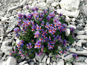
These are live, rare and precious witnesses of ancient cataclysmic events; Monte Cavallo can therefore be defined a “refuge oasis” (‘Nunatakker’) – a custodian of innumerable species which is virtually impossible to list in their entirety. Among the many, however, it is worth remembering at least – purely on an indicative basis – Alpine Bluebell (Soldanella alpina), Crocus (Crocus vernus et al.), Cinquefoil (Potentilla alpina); the Rhododendrons (esp. R. hirsutum and R. ferrugineum); Mountain Avens (Dryas octopetala); Alpine Buttercup (Ranunculus alpinus); Devil’s Claw (Physoplexis comosa); Heliantemum sp.; Pedicularis sp.; Monkshoods (mainly Aconitus napellus and A. vulparia); Saxifrages (Saxifraga sp.); Black Vanilla Orchids (Nigritella nigra); Edelweiss (Leontopodon alpinum); Columbines (Aquilegia einseleana and A. atrata); Mezereon (Daphne mezereum); Campions (Silene sp.); Pinks (Dianthus sp.); Primroses (Primula sp.); Gentians (Gentiana sp.); Bellflowers (Campanula sp.), Alpine Poppies (Papaver alpinus et al.) – and many others. The beautiful Geranium argenteum (already mentioned – and pictured – above) is a particularly noteworthy species that can be seen here, but there are also some other magnificent blossoms, such as those of Alpine Toadflax (Linaria alpina; pictured below), to be enjoyed.
Fauna. The original fauna is quite impoverished, as hunting – especially – has taken its toll in the past few years, when this practice was very active. A certain recolonization, however, is underway; it is therefore quite possible to see more or less rare and interesting animals. In the silence of the woodland, it is not so unlikely to bump into species such as roe-deer – which in the Cansiglio Forest has found its ideal habitat – or squirrels, always engaged in their tireless run from branch to branch, and tree to tree. Among the rodents, one can mention Common Hare and the much rarer White Hare, which in the winter season takes on a white coat (apart from the extremities of the ears and tail, which remain dark); mice of different sorts can also be spotted, and so Dormouse – tiny creatures that nonetheless cause no little damage to trees, with their bites on the young spruce specimens’ bark, often causing them to die down within a few months. Relatively common are also some small carnivores such as Fox, Weasel, Marten and Stone marten; Badger is instead quite a rare sight. Numerous – especially in the open meadows and in the vicinity of the ‘malghe’ (old dairy-pens) – are insect-eater little mammals such as Mole and Shrew.
As for the birds, in the majority they are passing through the area; among the non-migratory birds of prey Golden Eagles sometimes make their appearance, having some nests in the nearby Pre-Alps of Claut and in the Duranno area (a massif part of the Dolomiti Friulane); but occasionally they do nest also in Alpago. Present too are Goshawk, Kestrel and other small-sized hawks such as Buzzard. Some night-time birds of prey – such as Eagle and Tengmalm Owl – have become quite a rare sight instead, while some remain slightly more frequent – as Barn Owl and Little Owl. Among the Corvidae, Raven; the black Carrion and grey Hooded Crow; Jackdaw and Chough are present. Among the Tetraonidae family, the largest species is undoubtedly Capercaille; sometimes Black Grouse can be spotted too, as well as White Ptarmigan. Almost disappeared is Rock Partridge – maybe because of the dwindling number of sheep, on whose pastures they feed; while relatively common are still several birds of smaller sizes – such as Bullfinch, Cuckoo, Goldfinch, Hoopoe, Common Crossbill, Chaffinch – and numerous species of Woodpeckers, keen insect- and larvae-eaters, which they skilfully find under the tree’s bark: Green Woodpecker, Black Woodpecker, Great and Lesser Spotted Woodpecker – as well as the rare Three-toed Woodpecker.
Among the reptiles there are also certain species worth mentioning, such as European (or Asp) Viper, which is relatively frequent in open, stony locations as well as in the old – often abandoned – pasture lands; European Adder prefers more humid environments instead. The two latter species are poisonous, while the harmless Colubrids Smooth and Whip Snake can also be seen – and these are completely innocuous. It is impossible, also, to list all the invertebrates that live here – such as the many mollusks and spiders: everywhere there is an unfathomable wealth of life to be found. But the biggest surprises will certainly come from the systematic exploration of the many caves and sink-holes, populated as they are by a characteristic hypogeal fauna which has always attracted speleologists and passionate naturalists alike. Very common are the many insect species, with also the unpleasant presence of ticks – parasite acars which in the last few years have affected man (but there is no need to worry, as simple precautions can be taken against them when walking in the area).
Return from Alpago to Cansiglio
Return from Alpago to Italy-Tours-in-Nature
Copyright © 2010 Italy-Tours-in-Nature

New! Comments
Have your say about what you just read! Leave me a comment in the box below.