- Italy Tours Home
- Italy Ethos
- Tours 2023
- Blog
- Contact Us
- Dolomites
- Top 10 Dolomites
- Veneto
- Dolomites Geology
- Dolomiti Bellunesi
- Cortina
- Cadore
- Belluno
- Cansiglio
- Carso
- Carnia
- Sauris
- Friuli
- Trentino
- Ethnographic Museums
- Monte Baldo
- South Tyrol
- Alta Pusteria
- Dobbiaco
- Emilia-Romagna
- Aosta Valley
- Cinque Terre
- Portofino
- Northern Apennines
- Southern Apennines
- Italian Botanical Gardens
- Padua Botanical Garden
- Orchids of Italy
Val
Belluna, Nature and Art at the Foot of the Dolomites.
A Microcosm Between Alps and Pre-Alps
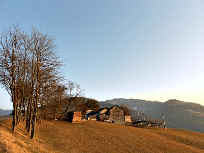
Val Belluna is the name given to the middle section of the Piave valley, between Feltre and Belluno. It is a serene landscape mostly made of gently rolling hills, with isolated farmsteads, open meadows and rows of trees (as in the picture above). It takes its name from the presence of the provincial capital, Belluno, elongated along the river Piave.
More than a connecting element, however, the “big river” was once a cause of separation between people and villages on the opposite sides – simply because of the sheer extension of its riverbed.
The so-called ‘Right bank’ of the Val Belluna (still known to this day as “Destra Piave”) – on the northern side of the valley – has always been the most frequented.
This side of the Val Belluna is dominated by the towering peaks of the Vette Feltrine, and – as a consequence – its traditional economy and land use were more typically alpine, as opposed to the more Pre-alpine setting of the southern side.
This latter section – known as ‘Left bank’ (“Sinistra Piave”) – on the contrary, is separated by the plains of Veneto only by a group of hills, and therefore the influence of the Venetian mainland has always been more detectable, leaving its mark on the local culture, and giving a more ‘urban’ feel to its towns and villages – something that can especially be appreciated in the architecture.
Despite that fact, historically, the left bank has always been less inhabited and frequented than the right bank. In ancient times, crossing the river was only possible with rafts and ferries – and particularly famous was the ford at Busche: it is the only point where the Piave narrows down considerably, before widening up again towards the south.
This is possibly the spot where the ancient via Claudia Augusta Altinate also crossed the river. Even to this day, there are only six bridges in the 30 km or so stretch between Feltre and Ponte nelle Alpi – and three of these bridges are in the centre of Belluno.
Nevertheless, despite the differences, both banks of the Piave were colonized since ancient times, during the Neolithic age at first, then again at the time of the Paleo-Veneti (the old pre-Roman population that gave the region its name, Veneto).
The ‘Left Bank’ (“Sinistra Piave”)
On the left bank, Mel and Trichiana were connected to the plains of Veneto by the low passes of Praderadego (910 m) and San Boldo (706 m).
The latter pass is still in use, and its road is a feat of engineering, with curved tunnels that were excavated during WW1 by the Italian army at first, and then finished by the Austrian after the reversal of fortunes following the Italian defeat at Caporetto (1917).
The hills behind Trichiana, Mel and Limana still present a soft, gentle and mostly wooded landscape, very little frequented; higher up, the area opens up in wide meadows which are renowned for their spring blossoms.
These hills, woods and fields were also the roaming ground of Bellunese writer Dino Buzzati, who celebrated local myths and tales in a famous count called “The Miracles of Val Morel” – from the name of a haunting yet serene plateau that hasn’t changed much since being immortalized in Buzzati’s words, and that is still famous today for its daffodil display in spring (as is also the case for nearby Pian di Coltura – see below).
Another notable feature of the area are the so-called ‘brents’ – which is a local word designating a geological phenomenon similar to the carving of a canyon. They date back to 8-10,000 years ago – at the time of the last glaciations – when carbonate acid in the melting ice eroded the soft rocks; this in turn revealed the bedrock, with its different colours and compositions.
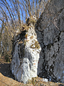
There are several of these ‘brents’ in the val Belluna: the most famous (“Brent de l’Art”; see below) is not far from Trichiana; three other are around Belluno (two along the Ardo stream, near the hamlet of Bolzano Bellunese, see the image below, and a third by the church of San Mamante, up the slope leading to the Nevegal), while another is in the vicinity of Quantin (municipality of Ponte nelle Alpi).
Mel, a Small Historic Centre
Undoubtedly, the main centre of the left bank is Mel, a fascinating old town with an interesting cluster of noble palazzetti (small palaces) in Venetian style, dating mostly to the 16th and 17th centuries.
In fact, Mel boasts one of the most beautiful squares in the whole of Veneto (Piazza Papa Luciani), encircled on all sides by a stunning sequence of elegant Renaissance buildings.
Amongst these, worth mentioning are the Palazzo delle Contesse (see below), the town hall with an airy colonnade on the front, and the ancient “Locanda al Cappello” – the ‘Hat Inn’ – with its unmistakable sign (a wrought-iron hat). Closing off the square is the baroque façade of the main church, which contains notable 16th century works of art in the interior; at the back is also the picturesque Chiesa dell’Addolorata.
From a corner on the main square, an arcaded passage under the harmonious Palazzo Pivetta quickly turns into an atmospheric pedestrian alleyway that descends the slope – over which the centre of Mel is situated – among old dry stone walls. This rustic yet fascinating walk can take you all the way to the small village of Puner, and is part of the ancient via Karera, a stretch of Roman road originally leading to the hilltop castrum (castle) of Mel.
In the vicinity of Mel an Iron Age site was also discovered; this is part of an important necropolis that turned the town into a notable archeological site. The finds (to which materials coming from private collections were also later added) are displayed today in the Civic Archaeological Museum, hosted since 1995 in the elegant setting of Palazzo delle Contesse.
In a nearby hamlet (Villa di Villa) are the ruins of the medieval Castello di Zumelle (Zumelle castle): built on a small hill, this castle – as can be imagined – had originally the function of a military presidium; almost certainly of Roman origins, it was later demolished and remodeled several times between the 10th and 14th centuries.
Albeit in ruins, today the castle makes for a unique visit, as it is the only building of its kind to have survived relatively intact in the province of Belluno. Completely renovated in recent years (in a rather questionable manner, one could argue), it is now being used as an exhibition space and for other cultural events; inside its walls – in the courtyard – the old storehouse, the keep and a well are visible, plus the tiny Early Christian church of San Lorenzo.
The reason why most defensive
structures and castles are no longer existing in this area is because, although
very useful in Roman and medieval times, they later became superfluous once the
territory fell under the influence of Venice in the 15th century; in fact, the
government of the Republic decreed the demolition of such military presidia,
but the owners of the land were granted the right to use the sediments to
build other types of constructions, if they so wished – hence the
transformation of many of those early castles into elegant villas and sometimes
even monasteries: this makes Zumelle castle even more unique.
The ‘Azure Cave’
Mel’s stunning azure cave (grotta azzurra) has become famous over the last few years: despite having always been there, it is a relatively recent discovery. It is a natural cave formed by the erosion of water, and it can be reached by following the course of the Rui upstream. The trail actually starts at the car park by Zumelle castle (described above), and it has been indicated in recent years with white-blue markings. It takes about 40 minutes to reach the destination. Because of the popularity of this newly discovered site of natural beauty, it is discouraged to visit on busy summer weekends; if possible, come during the week and preferably not at the height of summer, when it would be crowded on most sunny days. There are also safety issues around slippery stones, falling rocks and uneven path; also, it is not advised to start the trail during or immediately after rain, as there is the risk of localised flooding. Having said all that, the grotta azzurra is beautiful, and it was created by similar geological events as those responsible for the ravines known as brents, of which there are several examples in the area, some of which are particularly striking (such as Brent de l’Art, which is described below).
Walks and Trails on the ‘Left Bank’
In the area of the val Belluna, to the left of the river Piave there are many footpaths and bridle ways. They develop for several kilometers from the valley floors to the top of the mountains across valleys, slopes, wood patches and pastures, until they eventually reach the ridges. These were ancient tracks used by country people: woodcutters, hunters and shepherds who, until recently, exploited the resources of this territory skillfully, shaping the landscape in such an harmonious way as to preserve its original balance.
Villages, hamlets, isolated houses, farmsteads and the characteristic ‘malghe’ (dairy pens and cowsheds where cattle were traditionally taken for summer grazing, used for milking and as a shelter for both animals and cowherds – as well as small artisanal dairies for the production of cheese) can still be found scattered around these settlements, and there are numerous signs of the rural economy such as scythed fields, allotments, orchards and small fields – all cultivated in small patches – that form an harmonious mosaic following the typical setting of mountain agriculture, traditionally based on a self-sufficient economy.
Other features include dry stone walls, paved paths, ‘calchere’ (lime kilns), terraced fields, fountains, wells, shrines: all signs of the old rural traditional way of life – all but lost, but nevertheless still impressed over the territory.
The natural environment is noteworthy too: there are entire fields where daffodils – the flower symbol of the ‘left bank’ of the val Belluna – blossom in huge swathes. There are places renowned for their spring display such as Pian di Coltura, Monte Artent and Zelant, where people flock to see this wonder of nature around mid-May, in a sort of local small-scale Japanese-like cherry blossom ceremony.
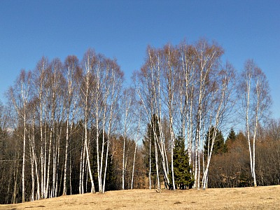
There are extensive beech woods, and spectacular canyons such as the Brent de l’Art and Rimonta stream ravines (see below); the fluvial ecosystems along the Piave are also worth mentioning, as well as the medium altitude meadows dotted with silver birch – another typical association of the southern Val Belluna (see image below).
There are also other areas known as ‘biotopes’, which are important for their exceptional vegetation, animal life and landscape; for example, the wetlands and peat-bogs at Valpiana, Canale di Limana, Pranolz, Buscador and the artificial lake of Busche, as well as the small natural lakes of Rimonta, Vena delle Villaghe and Col de Moi: these are all locations worth a visit for the nature lover.
The routes shown on the maps are there to guide the excursionist through these fascinating and often unknown areas, which make the ‘left bank’ of the Val Belluna one of the most interesting – and least known – sections of the river Piave.
In all the four municipalities of this stretch of valley – Limana, Trichiana, Mel and Lentiai – there are several possibilities for gentle hikes, and each town is represented by at least one guided walk, on which I am going to concentrate now.
The ‘Brent de l’Art’ Ravine in Trichiana
In the municipal area of Trichiana there are many places of botanical, geographical and geological interest, as well as from the viewpoint of the landscape. However, some areas are particularly important for one specific aspect; for example, some notable wetlands can be found in Pranolz and Busnador, while the river habitats around Ponte San Felice are noteworthy from an ornithological point of view.
The Brent de l’Art, near the hamlet of Sant’Antonio Tortal, is without a doubt one of the most characteristic and well-known natural features of the ‘left bank’ of the Val Belluna, where a nature trail has also been devised. Other notable locations in Trichiana include the areas of Pianezze and Monte Cimone.
The trail starts in the hamlet of Sant’Antonio Tortal, and in its first part it winds through flat open fields and meadows, still well cared for and peppered with some fruit trees (notably apples); characteristic hedgerows also follow the route.
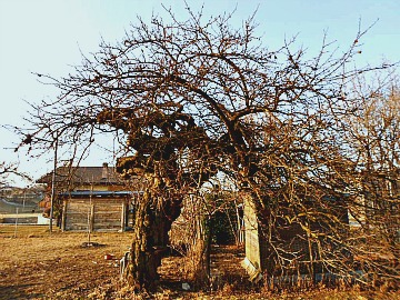
One can take notice here – and also on the surrounding hills – of the mosaic of fields and meadows that form the typical agricultural landscape of the ‘left bank’ of the Val Belluna; the two farmsteads of Case dal Magro and Col da Varda are other notable spots along the way. By the former are also two historic walnut specimens; traditionally, these trees were planted whenever a female child was born. On the corner of an old barn is a Madonna capital, covered in ivy, and nearby is a centenary wild plum, with a contorted trunk and expansive canopy – unusually so for this type of tree (see image below). Here the views can sweep freely over the hills and cultivated fields of the Val Belluna.
Before reaching the canyon – a spectacular ravine eroded by the stream – the route passes by a characteristic, small abandoned farmhouse at Col da Varda, where the small windows and the barn built alongside the house both indicate a type of vernacular architecture, and where there are still farm and domestic animals, reminding one of traditional agricultural activities. Also, as well as seeing many insects and bees, it is not infrequent to hear here the song of Jay – birds that like to live in areas with an abundance of birch and oak. From this location onwards, the scenery changes dramatically, and the trail descends through an arid, barren landscape: the fields are now colonized by numerous Juniper bushes and small pioneer trees such as Scots' Pine, Silver birch and Hop hornbeam.
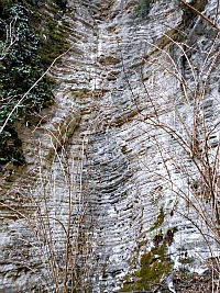
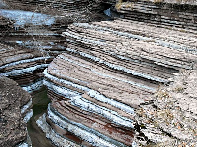
Finally, the route leads to the ravine proper, where the stream's erosive action has created a canyon over a long period of time – a real wonder of nature carved in the bicolor formations of ‘scaglia rossa’ and ‘scaglia grigia’, both of which are soft rocks composed mainly of carbonate mud, compacted sands and clays, disposed in alternated reddish-pink and grayish-white layers that create an astonishing, unique sight (see image below).
This was probably an ancient pelagic sea bed, originally a few hundred meters deep: in the case of Brent de l’Art, also, it is very likely that the canyon represents a gap opened up by the stream in relatively recent times but following an ancient landslide that had submerged the old valley, thus forcing the stream to open up a new route to its left side.
Once reached the bottom of the ravine, the environment is quite extraordinary: the vegetation – despite being firmly anchored to the rock walls – seems literally suspended in the void, while the water flows deeply embedded among red coloured rocks; where it outflows, it forms pools frequented by amphibian creatures, while the flight of the Dipper (merlo acquaiolo) and the acute cry of Yellow Wagtail complete the scene, creating a unique picture in its genre. Past the Brent de l’Art, one can continue along the old road towards Passo San Boldo, then abandon it by a bridge over another small gorge in order to return to Sant’Antonio Tortal, thus completing the circular trail.
The ‘Brent de
l’Art’ proper
The term ‘brent’ derives from the dialect of the Valbelluna and indicates a stream that runs at the bottom of a deep, narrow valley. From here derives the term ‘brentana’, which identifies the moment in which the stream, after days of heavy rain, deepens and speeds up. ‘Art’, as a dialectal form of the Italian ‘Ardo’, derives from ‘artus’; that is, rocky gorge. The Ardo is a tributary of the Piave, which is not to be confused with another namesake, crossing the city of Belluno, and that is also a tributary of the Piave.
These ‘brents’ a natural phenomenon, very similar to a canyon, due to millions of years of natural erosion by water, which has also uncovered rock layers formed millions of years ago.
This erosion is due to detritus which the water carries in these narrow valleys. The rocks removed by the water hit and rub the rock walls as they enter the narrow gorge, thus contributing to its carving, then flow downstream. The running water in such a narrow valley is also responsible for the characteristic sound, which gets amplified by the enclosed rock walls – something which cannot easily be heard in a wider valley.
It is presumed that the most important phase, for the natural carving of the canyon, lasted between 10,000 and 15,000 years, in coincidence with the melting of the ice, following the end of the Wurm glaciation, which ended around 9,000 – 10,000 BC, This natural carving continues, although in a much weaker form, to this day.
It is not rare to find, in the narrowest sections of the canyon and on the bends, rough stones and pebbles of an almost perfect round shape. These are the stones which, getting caught and spinning in circle against the rock walls, contribute to mould and carve the rock, contributing to create the characteristic canyon shape.
The typical red colour of the ‘brent’ is due to the presence of a rock, the so-called Cretaceous “Scaglia Rossa” (‘Red scale’). This is a rock type which was formed during the Upper Creataceous (90-65 millions years ago). It is composed of deposits of carbonate muds, mixed with planktonic fossil husks (from marine invertebrates), which also make it a very easily eroded, even though it presents a good stability when vertical. This rock formation creates the rock walls of the canyon, revealing its calcareous-marly layers, generally of a brick-red colour, due to the presence of iron oxides, alternated with whitish layers due to a secondary colouring, both alternated with further layers of red and grey-green clay. These peculiar geological characteristics witness the majestic beauty of the site, a place that allows for an exceptional plunge into the depths of time.
Art and Nature in
Lentiai
Like the other ones, the Lentiai nature trail is also circular; it starts and ends at San Gervasio – a small group of houses gathered around a tiny church dedicated to the saint which bears the same name as the hamlet. The walk is easy and it follows old bridle ways, once used for agricultural purposes.
The open areas of Col Frontal and Busa del Gat (literally, the ‘cat’s hole’) are covered with flowers in spring, and dotted in summer with characteristics hillocks of hay – a sure sign of the agricultural traditions of the area, which are partly still alive.
The real highlight of this walk, however, is the splendid blossoming of daffodils that, in May, accompany the walker all along the route. This flower, as said before, has become the symbol of the mountains of the ‘left bank’ of the Val Belluna, and there is a celebration in its honour during the flowering season.
Blackthorn and Beech respectively are the main bush and tree species to be encountered in the wood thickets along the way, while Lime occasionally also offer welcome shade along the route – as well as an intoxicating scent in June (at Stabie there is a monumantal specimen too). Several rural buildings can be admired en route; these were used by farmers to shelter their animals during the summer.
If you branch off the main road at Busche, the left bank of the Val Belluna is connected to its right bank by means of a long, artificial dam on the river Piave, over which runs a busy bridge.
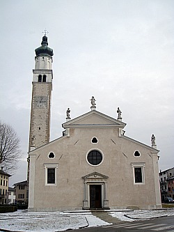
But apart form nature, Lentiai is also an interesting roadside town with a graceful monumental church. The church of Santa Maria Assunta (see image above) was erected in the 14th century and remodeled in a Renaissance style in 1568. Its interior displays a magnificent wooden ceiling with 20 boards (“cassettoni”) depicting the Story of Mary, executed by Cesare Vecellio – a renowned artist belonging to the same family as the more famous Titian (see Pieve di Cadore).
In this church there are also other important works of art by Renaissance artists such as Palma il Giovane, Giovanni da Mel and the Pordenone, while one of the figures in the main altarpiece (the “Polittico dell’Assunta”) is said to have been painted – according to tradition – by Titian himself, even though there is no evidence of that. The slender bell tower – an unmistakable landmark from many miles afar – was erected in 1515.
Continuing on from Lentiai on the left bank, one reaches again the historic market town of Mel (described above), and the road eventually leads to the provincial capital of Belluno, while always keeping on the same side of the river.
A series of high and very little frequented roads also connects the municipalities of Trichiana and Limana to Belluno through small villages and hamlets, while crossing areas of meadows and isolated farmsteads mostly devoid of human presence. A good option is to take the road from Sant’Antonio Tortal to Val Morel, and then continue from there on a single track lane to the Nevegal (the small ski-resort south of Belluno).
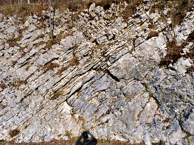
This road passes by several interesting rock formations, and it is sometimes carved in the rocks themselves (see picture below); a few hamlets with noteworthy examples of traditional architecture are also encountered along the way; however, although highly atmospheric, this road is best avoided in winter or with high snow.
Limana and Its Surroundings
The proposed itinerary goes through the places that inspired Dino Buzzati – an artist and writer from Belluno – in writing the work titled ‘I Miracoli di Val Morel’ (‘The Miracles of Val Morel’). Following the old cart-road which starts down in the valley and that goes all the way up to the wide grasslands of Valpiana and Val Morel, it seems – at least ideally – to walk together with the famous writer and artist, who used to stroll exactly along these same paths. The itinerary gives us a chance to observe capitals and other signs of popular devotion close up – like for example the little shrine of the ‘Madonna del Paré’ and the path of the ‘Way of the Cross’ (‘Via Crucis’). These latter artifacts inspired Buzzati to imagine the small chapel-shrine of Santa Rita, which is the symbol of the book ‘I Miracoli di Val Morel’.
The itinerary develops in a remarkable landscape, which displays wonderful views over the Piave valley, with Belluno and its Dolomites in the background. Aspects linked to history, art and the popular tradition of Saint Rita – as well as to nature – meet along this route, where it seems to feel the mysterious presence of the guardian of the shrine, or to notice – behind a hedge – his little home “… with dry-stone walls and a wooden roof” (Dino Buzzati).
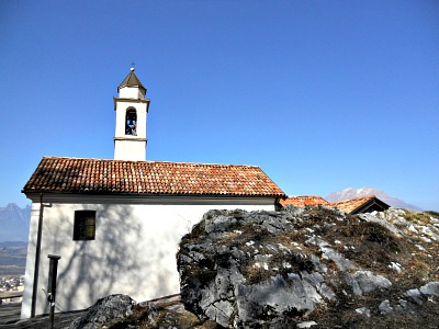
The realization of the itinerary of the ‘Via Crucis’ dates to 1842, when 14 capitals were erected in occasion of the restoration of the ‘Madonna del Paré’ church (pictured below), and as the access road was enlarged. The name for this building has its origins in the epithet of ‘Dei parens’ – that is, “Mary, parent of God”; it is certain, however, that a small religious building stood on this location since 1519 (but probably from at least a century earlier). When the church was restored it was in quite a bad state of preservation, and a new decoration was then executed by a painter from Belluno, G. Moech. The area was frequented also by a few hermits, whose presence has inspired a strange count, half-truth, half-legend. The character is a local hermit who allegedly had embarked on a pilgrimage to the Holy Land; after traveling on foot for 14 years he returned to his shelter, only to find it occupied by another hermit, who refused all possible forms of co-existence, thus forcing the ‘first’ hermit to leave again, and disappear forever.
The position of the hill of San Pietro in Tuba always made it a vantage point over the Val Belluna and some side valleys; for its strategic position, therefore, the site was already frequented in ancient times (between the 13th and 9th centuries BC), when it was probably a fortified site. The location retained its importance in ancient and Roman times, as well as throughout the Middle Ages; Goths and Byzantines also built a castle here – as an integral part of a defensive system that covered the whole area. In the following centuries, the fortified structure was flanked by a Cistercian monastery and a church was erected, dedicated to St. Peters (1185), while the monastery was mentioned for the first time in 1277. Apparently, even St. Bernard spent a period of meditation on the slopes of this hill, while it remains to be confirmed the presence of the Temple Knights, who – according to a fascinating hypothesis – would have gained possession of the site for a while (during the 13th century); then, throughout the Middle Ages, this remained an important devotional site for the area. During the 14th century a contingent of Teutonic Knights took stance here, in the castle: this was a particular order of monastic knights; after they left in 1366, the fortification was demolished. During the 16th century the monastery also fell into disrepair and eventually ruined, but traditional pilgrimages on St. Martin’s day (on November 11) continued for a while.
The small chapel-shrine of Santa Rita is inextricably linked to the figure of Dino Buzzati: in the ‘I Miracoli di Val Morel’, the writer imagined the existence – in the vicinity of Val Morel – of a chapel-shrine dedicated to Saint Rita, to which were referred 39 ex-voto that he had already painted with miracles ascribed to the saint; at a later stage, it was suggested that he turn this idea into reality. Dino Buzzati was enthusiast, and he executed the picture that was later exposed in the shrine. The project did not stop with the death of the artist in 1972, and a chapel was finally erected in this atmospheric location, near the large lime tree where Dino Buzzati himself would have often stopped to contemplate the magnificent view over the Val Belluna.
In terms of geology, in the area of Val Morel the geologic substrate is not coming very much to the surface, and it is characterized by marine sedimentary rocks belonging to typical formations of the Alpine chain: Flysch, Red Scale (‘Scaglia Rossa’), Fadalto Limestone, ‘Biancone’ – the latter being the most abundant (see picture below). The wide valley of the Canale di Limana is characterized by a widespread cover of glacial deposits, left by the streams and recognizable by the presence of non-local rocks, which were translated down from the highest mountains of the province. These eroded fragments – transported and abandoned in the valley by the slow movement of the glacier – are constituted of porphyry, dark volcanic rocks, Dolomite and ‘Green Stone’ (‘Pietra Verde’).
The superficial terrain (‘topsoil’) of the flat clearing of Pian del Vescovo hosts interesting patches of wetland (‘wet meadows’) and remnants of peat-bogs: it is a particular environment characterized by a strong accumulation of organic matter, partially decomposed. The formation of these soils happens as a consequence of two distinct processes, related and often sequential: the sinking – and progressive filling up – of small water basins, and their transformation into bogs. The flora of a peat-bog is characterized by peculiar species; in June the light and candid tufts of Eriophorum angustifolium dominate the landscape with their fluffy heads.
The ‘Right Bank’ (“Destra Piave”)
As anticipated earlier, the 'right bank' of the Piave has always been the most inhabited – and it still is to this day, especially since the National road runs on this side of the river. This means that the towns crossed by when travelling eastwards from Belluno – Sedico, Santa Giustina, and the lower section of the municipality of Cesiomaggiore (by the ancient ford at Busche) – are now linked almost without interruption.
But that was not the case in the old times, when the main thoroughfare actually followed a more secure route at the foothill of the mountains to the north, connecting the townships of Sospirolo, San Gregorio nelle Alpi (noteworthy, near here, is the hamlet of Fumach – a group of buildings in vernacular architecture remained almost untouched) and the centre of Cesiomaggiore, eventually leading all the way to Feltre.
From most of these towns, it is also possible to access the Dolomiti Bellunesi National Park: for instance, from Cesiomaggiore and Santa Giustina one can easily enter the Val Canzoi, one of the Park’s main gateways.
It is interesting to note that this area, to this very day, is still literally peppered with old Venetian villas and churches – all signs of an intensive use of the land that was never exploitative but actually very much in balance with the availability of resources.
In fact, this marked a respect for the natural environment which sometimes verged on the sacred, and that certainly contributed to create an harmonious landscape, sometimes still detectable today here and there.
Santa Giustina: the Old Mill of Santa Libera
The old mill of Santa Libera, situated in the hamlet of Salzan, has recently been bought and restored by the municipal administration of Santa Giustina, who set up a small museum there and destined it to cultural activities. The building, after the last miller left in 1981 (after having worked there for over 80 years), had been left idle, and was in a state of advanced degradation.
The mill is now in perfect working conditions again, and the destination of numerous visits – especially from school groups – since when, in spring 2004, the municipality – after seeing to its renovation – has inaugurated its reopening. This building represents the terminal section in a row of houses that face onto an old farmyard. It consists of two floors, of which the ground floor hosts the pieces of machinery and the equipment for the milling activity, while the upper floor – already set up as a granary in the past – now serves as exhibition space. The wheels of the mill – originally three, now two – are fed by a nearby conduit (or millrace).
The restoration work was carried out in such a way as to recuperate as much as possible of the preceding structures, both external and internal, including the mechanisms for grinding, as well as presenting a faithful reproduction of those tools that had irreparably been damaged by the passing of time and use. The Zanandrea family has excercised the milling activity (both wheat and corn) here for several generations; some of them had even worked for the Austrian during the occupation. This mill was the last one in the area where it would have been possible to find freshly ground flour, and people would travel long distances to come and buy it. The last grindstone was taken here from Brescia around 1888, when the railway arrived only as far as Cornuda; from there, it had to continue its journey on a cart waggon, draught by oxen.
Since then to the moment in which the mill ended its activity, the grindstone was consumed about 20 cm; every two months the miller would have had to take it apart to redo the small channels – an operation that required, roughly, a day of work. The miller’s typical day was long: it started at around 4 am and would continue – except a break around lunchtime – until about 4 pm. In all the years of the mill’s long activity, the conduit (millrace) never ran out of water, and in periods of drought the Mulino di Santa Libera would also do the work of other mills. We still have old pictures that represent the last ‘historic’ miller, Leandro Zanandrea, intent at gathering in the tub the flour that came out of the millstone’s small channels.
According
to the statistics of 1947, the daily capacity of this mill amounted to
1200 kg of wheat and as many of corn; the wheels were activated by
water, with a leap of about 4,29 meters. The wheels were protected by a
vine plant, so to prevent exposure to the sun, which could bend them.
Leandro had inherited the mill, together with his brother, from his
father, but since 1976 he was left running the activity alone. He was
the last in the Zanandrea lineage to exercise this trade, that had been
initiated here by his ancestors in 1852. The mill, however, is
documented already since 1529, when it had two wheels, a stable and a
yard. During the course of the 1500s and 1600s the mill underwent
several changes in property and management. Some documents of 1625
attest to a first change of ownership (but the keeper would be a
different person), while at the beginning of the 1700s the mill became
part of a property-estate of a Venetian family, who kept it until the
mid-19th C. In 1849, the ownership changed again; some years later, the
Zanandrea family succeeded.
The Altanon Hostel near Cergnai,
Also located within the Municipality of Santa Giustina, the mission of the Altanon hostel is to encourage eco-friendly, responsible tourism through an experience of relationship with the environment and the people who inhabit it. The hostel is part of a constantly evolving project, which discusses the theme of sustainability and puts it into practice too, paying attention to the products used and the consumption of energy resources. For its commitment on these issues, the Altanon hostel has been rewarded with the Quality Mark of the Dolomiti Bellunesi National Park.
At the hostel, the table becomes an occasion where to share knowledge as well as conviviality! The hostel is the ideal place where to spend a few relaxing days surrounded by an all-embracing nature. It hosts cultural initiatives and aims to divulgate a commitment to sustainability issues, as well as promoting environmentally-aware hiking, trekking, geo-tourism, guided nature walks – and more. The guests are asked only to bring along curiosity, an open mind (and spirit) – but proposals too, as the hostel is also a place of exchange, where relationships and new visions can arise.
About the hostel. Number of beds: 24. Two dinner rooms, also suitable to spend some time reading and relaxing; a lovely wood-covered terrace facing directly the Veses creek. Two bright and spacious lofts are suitable as multifunctional workspaces and perfect for courses, workshops, meetings, small conferences, projections or other activities. Outside, the hostel is surrounded by woods and meadows where to walk, and other places where to relax – such as the hostel’s “organic garden” and the banks of the stream. Services: B&B (full or half board), with seasonal and local products; services for cyclists include covered boxes, workshop, bike info point and specific discounts. Discounts are available also for children, large groups and long stays; pets are welcome. Free wi-fi, small thematic library, conference room; events can be organised on request too. Opening times: every day from April to the end of October; in other periods open upon request, and for groups only.
The Water Trail Along the Veses Stream
We are still within the Municipality of Santa Giustina, but rising along this section of the Water Trail we progressively enter the protected area of the Dolomiti Bellunesi National Park, and we are also among the areas included within the Dolomites’ UNESCO World Heritage Site (described below). Here we can observe the marks left by water over the landscape – at present times but also in the past, from the retreat of the glaciers up to today. Nowadays, water still permeates these environments; it flows inside the rocks and between the sediments, but we can find it among the vegetation too: over the leaves, in the mosses and over the wood. It spreads along, but then it also concentrates in streams to converge into the creek; in short, water favours the presence of life in its manifold forms.
This valley is indeed a magical place, full of small rural settlements located near the area of the springs (the so-called ‘Acque More’; that is, literally, ‘dark waters’), from which also the aqueduct of Santa Giustina draws its water. It is a rich cultural landscape, which can express itself through fascinating stories based on myths and legends of ancient derivation. It is a territory that has in fact received a huge inheritance by water; and so, we will follow the ‘Trail of the Water’….
Take-home message: along this trail we will be able to understand how man can obtain electricity from water (at the hydroelectric plant “Centrale dell’Altanon”,
just beside the hostel), and we will also dive into the balanced
presence of water in nature, understanding how it accompanies both flora
and fauna “by the hand”. We will progressively immerse ourselves in
sensations of deep nature as we delve more and more into the woodlands
of the Valscura (literally, the ‘dark valley’).
Birds of The ‘Water Trail’
Aquatic environments are important feeding sites for insectivorous birds that seek their prey near water (in correspondence of streams, ponds, lakes, etc.); robin, for instance, sometimes chooses these habitats as hunting ground. Birds do not use water only to drink, though: in fact, with a little luck, they can be observed as they wash themselves in pools of water, shaking their plumage in order to get rid of pests and mites.
Two Showy Subjects: Among the birds specialised in the capture of aquatic insects there are Grey Wagtail (Motacilla cinerea) and White-throated Dipper (Cinclus cinclus). Grey Wagtail lives near wetlands and feeds on aquatic insects, larvae, small molluscs, tadpoles and – occasionally – small fish too. This bird has a striking plumage: you might see it while resting on a rock, or performing a dance by moving its tail up and down. White-throated Dipper is the ‘diver’ of our rivers; it feeds on small crustaceans, fish eggs, larvae and aquatic insects that it catches at the bottom of the streams: it dives into the water and walks against the flow, along the stream bed, moving its wings like oars. When walking along the Veses creek, if you catch sight of a bird flying straight, fast and low over the water, then most likely you have spotted a White-throated Dipper!
The Tawny Owl (Strix aluco) is a nocturnal bird of prey that animates the nights of these Pre-alpine regions. It defends its territory all year round by emitting a deep whistle similar to a flute note, which scares some people, but – contrary to popular belief – the nocturnal birds of prey are not harbingers of bad luck; indeed, if we are lucky to hear their song, we should consider ourselves privileged for having been so close to these extraordinary animals! This bird shows some special adaptations in order to hunt mice and voles at night: an exceptional sight, a fine hearing, and a plumage that makes it extremely silent when in flight. As opposed to Little Owl (Athene noctua) and Long-eared Owl (Asio otus) – also present in these areas, but which prefer agricultural environments – the Tawny Owl lives in mature broadleaved woodlands, where the abundance of trees of large dimensions favours the presence of holes in the trunks, where it can nest. This small creature observes and accompanies us: despite being among the birds with the most nocturnal habits in the area, one can occasionally spot its presence even in broad daylight, as it rests; sometimes, in fact, Tawny Owl has been seen while resting over the chimneys of the Altanon hostel – and for that reason it has been chosen as its symbol!
When Water Was Ice
During the last Ice Age (the so-called ‘Pleniglacial’ – about 22,000 years ago) the valley of the Piave river and the val Scura were less deeply incised than today, and filled with ice; only the tops of the mountains came out of those ice sheets. When the glaciers retreated, they left many signs – especially thanks to the action of water, slowly freed over time by the melting of ice; then, during the last Ice Age or ‘Late glacial’, the ice tongue that occupied the val Scura suddenly broke away from the main Piave glacier.
And the Ice Became Water Again. This separation took place progressively, through a phase where the tendency was that of a general retreat, alternated however with phases of advancement that saw the front of the Veses glacier come close to the Piave glacier again. The icy water and the melted ice, alternating for a long time, allowed erosion and depositions to reshape many forms of the landscape.
Glacial Signs. An important evidence of this story is a deposit made of stones of different sizes cemented together (a frontal moraine deposit), two sections of which are preserved in the valley. We can observe one of these along the trail, the other being placed at the same height on the opposite side of the valley, in the highest part of the Burbai meadows. The deposit was originally a whole, single arch; this deposit, released during a retreat pulsation of the Veses glacier, was eventually smashed and partly eroded by the water of the stream that has carved its way through the valley over the millennia, until giving it the actual shape.
Waters of the Past
Some sections of the route are characterised by a less steep incline than the rest of the mountain slope where the trail develops. Some very elongated terraces are arranged in an east-west direction, and characterised by meadow clearings bordered by woods. These forms are due to water erosion and the consequent deposition that took place about 15,000 years ago – in the Late Glacial Period. These ‘waters of the past’ have shaped the abundant deposits left by the retreating Piave glacier – and by other secondary glaciers (including the small one that descended through the val Scura), which flew down from the side valleys and joined the main Piave glacier. These waters were produced by the melting ice, channelled at that time into fluvio-glacial systems extending over a broad plain on the valley floor.
The Ancient Piave River. The rambling and flowing of these waters – regulated by winter drought and summer floods – occurred along the fluvio-glacial plain (‘sandur’), which can be considered the ancient bed of the Piave river (or ‘Paleo-Piave’).
The Anguane
In these valleys also live the Anguane: they are elf-like women similar, in all respects, to nymphs. Some say that they are really beautiful; others assure that they are ugly and elusive; in either case, these beings of the forest are able to transform themselves into aquatic animals or into impalpable, ethereal shadows or sighs. Sometimes the Anguane make their appearance near ponds and streams – even at the town margins – to celebrate with music, singing and magic rituals; at other times, they just dive silently.
The Spirit of the Anguane. Whoever was discovered to spy on them in order to steal their secrets, could incur into severe punishment; woes also to those who unwisely dared to go to the washtub at sunset. The Anguane are usually associated with the act of “doing the laundry” – although they are never good at it! Some swear to have seen them, beautiful and dressed with long skirts that cannot entirely hide their goat-like feet; others have even married them, and brought them down to the villages – but be aware: never call them ‘goat’s feet’, if you do not want to see them vanish in thin air! The symbol of their breasts, however, always accompanies them, depicting them as perfect mothers, naturally made to nurse: at night-time, they always discretely return to care for their beloved children. If you want to know more about the Anguane, also visit the page on the Legends of the Dolomites.
And The Water Gushes Forth... Water falls from the sky in one of the passages of its perennial, cyclical rambling into the environment. When it falls, it glides, naturally slipping under things; if it meets fractured limestone, water enters between the rocks and into them through porosity, and it can travel for miles within the fractures. When it meets a less permeable substrate, or a cut in the rocks, however, it returns back to the surface, where it starts to flow again.
Why is This Water Gushing Here? Let’s find out the reasons for the numerous springs or ‘risorgive’ (resurgent pools) present in this area: 1) upstream, there is a broad alluvial fan, made mainly of permeable deposits (gravels, pebbles, sand), which lays on less permeable, marly rocks (‘molassa’); 2) further upstream still, along the mountain slope, the rock substrate is permeable and can contain – and convey – water (this is mostly limestone and marly limestone of Jurassic and Cretaceous age). The proximity of the so-called ‘Linea di Belluno’ (Belluno fault – a strong tectonic disturbance) leads to the assumption that part of the water from these springs may come from deep sediments, and be transported by pressure along the tectonic discontinuities. This is why water can gush abundantly only here, consistently feeding the Veses stream.
Dragonflies: Strange Inhabitants of These Waters
As A. N. Cibele points out in her “Venetian Popular Zoology” (1886), dragonflies are insects that intrigue one – and especially so the children; here they have different dialect names, such as ‘balanzette’ (literally, ‘little scales’), ‘anzoletti’ (‘little angels’) and ‘cavaoci’ (similar to the popular English expression ‘eye snatcher’, because they usually fly fast – and with sudden dodges – straight in front of people’s faces), but don’t worry: for humans, dragonflies are harmless insects altogether! Male dragonflies are easier to take notice of because of their bright green, blue and turquoise colours, and because they usually fly close to us, to warn us that we have entered their territory. Females, on the other hand, display less flashy colours – mostly brown tones – and they show a more reserved behaviour too, as they spawn on the submerged stems of aquatic plants.
The Dragonfly Larvae. The one- to three-year-long larval stadium of dragonflies is extremely interesting, since the nymphs spend this entire period swimming under the water surface, breathing with gills. After a delicate metamorphosis, the adults start to breathe air instead, and will fly. The dragonfly larva is an exceptional predator – not only on other water invertebrates, but also on tadpoles and fry. It is equipped with a deadly snap-mouth, and it would almost seem that special effects’ creators have been inspired by the very system of predation displayed by the dragonflies’ larvae in order to invent the dynamics of the monsters’ mouths in some famous scary movies. Also, when present, these insects indicate – like many others, in fact – the good quality of water and air.
Activity: Use your Hands and Imagination. In order to build a dragonfly – usable as a hair clip, pendant, or as a lucky charm – all you need is a clothes’ peg to be coloured, and four oval wings of tissue paper to be glued on it, two on each side: it only takes a bit of imagination, and it will fly!
The Small Church of S. Vittore Veses
Situated in a location of great charm, the church dedicated to Saints Victor and Corona is immersed in the silence of nature, and is an ideal place where to relax, read, meditate or… sleep! Its coolness in summertime, the scents of spring, the mosaic of colours in the autumn and the magical atmosphere of winter make this location an enchanting place in every season. The church of S. Vittore Veses is one of the numerous buildings that witness the felt religiosity of the local communities, as well as the widespread diffusion of small places of worship in this territory. Saint Vittore was a Christian legionnaire, at the times of the Emperor Marcus Aurelius, who never gave up on his faith – not even under torture; for this reason, he was beheaded. The cult of the saint is linked to that of St. Corona (or St. Stephania), who was also subject to martyrdom for having supported and encouraged Vittore to withstand torture. The remains of the two martyr saints are preserved in the magnificent Sanctuary of St. Vittore and Corona, near Feltre, dedicated to them.
The small church here, instead, was first mentioned in 1587, in the minutes of the pastoral visit of Bishop Rovellio. In his successive visit of 1595, finding the church in a state of disarray and near abandonment, he would order its demolition; luckily, the order was not carried out. Also Bishop Gardenigo, in 1611, took notice of the absence of flooring and the general neglect of the structure – so much so that he defined the building ‘est stabulo similis’ (similar to a cowshed). The chapel was renovated before 1760, and then utterly rebuilt around 1870, as it had collapsed following an earthquake. In 1905 the ‘Altanon society’ built the power plant (described above); five years later, it offered a substantial contribution to the church’s restoration. Three wooden statues were kept in the interior: a statue of the titular saint, St. Victor, one of St. Corona, and a Virgin Mary with a child; in 1979, however, the statues of the two saints were stolen, and only that of the Virgin Mary remained, now located in a safer space. Even today, on May 14th each year, the local parish gathers the faithful on the occasion of the celebrations for the two patron saints.
Monte Pizzocco and its ‘Heart of Stone’
Monte Pizzocco (2,186 m) is part of the Dolomites UNESCO World Heritage Site, and it displays some very specific forms due to its peculiar tectonic structure. The southern aspect of Monte Pizzocco is cut by a huge plane dipping to the north (the so-called ‘Linea di Belluno’ – or ‘Belluno fault line’). This plane allowed the oldest rocks (belonging to the Main Dolomite Formation – Upper Triassic, about 210 years ago) to thrust over some younger rocks (Jurassic limestone and Cretaceous formations – dating from about 200 to around 65 million years ago), when Africa and Europe collided. Monte Pizzocco responded to the compressions also with other evident structures – such as folds, faults and fractures. Surprisingly, water accompanies these rock formations – which were deposited in marine environments – since millions of years, and with a little fantasy we could say that these mountains are now witness to ‘fossil seas’ (or, more precisely, to ‘fossil marine waters’).
Main Dolomite. This is a powerful sequence of rocks, stratified in regular layers, which testifies how the Dolomites – during the Late Triassic – were an extended shallow lagoon (‘tidal flat’), periodically covered by the sea. In this tidal flat, a large amount of white carbonated mud accumulated, thus recording the cyclic variations of the sea levels for millions of years. The first dinosaurs would have walked over these muddy plains, leaving some fossilized footprints behind.
Jurassic Limestones and Other Tertiary-Cretaceous Formations. During the Jurassic the Dolomites’ region quickly sank, because of the opening of a gulf in the northern Atlantic Ocean. The southern portion of the Dolomites, therefore, recorded a gradual shift from shallow-sea conditions to a deeper marine environment – a veritable ‘oceanic tongue’; part of this ocean developed along an axis which is now the Valbelluna (namely, the Belluno basin). During the Cretaceous period, the clash between Africa and Europe triggered the lifting of all the aforementioned rocks, thus raising the Alps and closing the ocean that had previously opened. The Cretaceous sediments – which were deposited in what remained of the Jurassic ocean, by now a shallow sea – record the presence of materials eroded from the first, ‘young’ Alpine mountains. Moving on to the Tertiary period, the residual seas became progressively narrower, and were filled by more sediments; thus, emerged lands began to dominate the region.
Woodland and Water
On periodically flooded river banks, where the humidity is always higher than in the surrounding areas, and plants are often in contact with water, you will find species that do not run the risk of rotting, even if submerged: these are trees like Black Alder, and shrubs such as different species of willow.
Colour Shots. The bushes of the oriental Buddleja davidii – a non-native plant that has spread abundantly along the shores of streams, thanks to its ability to root even in difficult deposits like rock and gravel – are really eye-catching. Buddleja is also known as ‘butterly bush’, since these are attracted in droves by its fragrant, fuchsia-coloured flower clusters. During springtime, instead, the bright yellow flowers of Caltha palustris stand out above the large bright green leaves, as well as the blooms of the many wild orchids that show up in these cool and damp places. In this area, the yellow Caltha grows along abandoned grooves, following the light tracks left over in the woodland by streams fed by invisible springs that have now disappeared: these are the very moist habitats that Caltha prefers.
Activity: Listen and Discover. Sit by the trees, and wait patiently. What sounds do you hear? Is there something fleeing from us, scared? The animals living into the woods and in the meadows always notice our presence, however discrete we try to be. If you are close to the Veses creek or to some springs, the sounds will be richer, stronger and louder; the encounters will be easier too. Water hides us, and helps us to see the wild animals better: look for the tracks left over by deer as they come close to the stream, every day, to drink some fresh water.
Mosses, Lichens and Ferns
Between drystone walls, among the roots of trees, over outcropping boulders, between rock fractures or on the walls of some houses, we usually find a type of pioneer and versatile vegetation that prefers the most awkward places – in the shade, with high humidity and a cool climate.
Water Born. Mosses are the most ancient terrestrial plant forms, which – together with the even more ‘strange’ lichens – have been the first colonisers of mainland that managed to survive out of water.
Plants Without Roots. Mosses and lichens do not have roots: they can simply lean and anchor themselves to something. Their reproductive cycle depends on water, which is like a ‘womb’ to them; they reproduce by releasing clouds of impalpable spores – exactly like mushrooms and ferns.
Ferns – Happy to Have Roots. Ferns can be described as ‘fossil plants’, as they have crossed millions of years intact – probably being amongst the typical food of dinosaurs; they are still present today, virtually unchanged, in many ecosystems. Ferns were the first plants to develop roots, thus marking the transition from ‘plants being accustomed to lean anywhere’ to ‘plants that stopped in a specific place’ in order to complete their life cycle. In the val Scura, ferns are usually found near rocky areas characterised by the phenomenon of dripping: a continuous flow of water from the overhanging rocks that creates ideal growing conditions – as well as atmospheric reflections and iridescent mists.
Activity: Look, Discover and Document. Without picking them up (because they are protected, just like lichens and mosses), approach ferns to admire and photograph their immense variety, and describe them in their typical environment.
The ‘Signs of the Woods’
The increasing abandonment of forestry practices and of mountain agriculture imposes a limit to the possible improvements to the biodiversity of these environments: one of the most noticeable effects of this abandonment is the expansion of the forest. Nowadays, interest in the cultivation of Norway spruce is dwindling, after having been subsidised in the first half of the 20th century; this results in a reduction of those unnatural presences and in the reappearance of the more typical mixed deciduous forest. In these young and fresh woodlands grow Hornbeam, Maple, Oak, Ash and Beech; in autumn, these trees decorate the woodland with very showy colours. Many animals – because of the abundance of seeds and fruits – inhabit the deciduous forest: to them, this is a real ‘pantry’ provided by nature, where sometimes they choose to find refuge amongst roots, trunks and branches.
The Forest Takes Its Space. In the meadows and in the woods, where there is enough light for them, Hazel and Bramble shrubs live their precarious existence, with fruits appreciated by man and animals alike, being also perfect hiding places for small birds that take shelter from predators. There are plenty of other fruit trees too, which once lived solitary in the middle of large meadows, or near houses and farmsteads, and that today seem absorbed by the woodland: these are Cherry, Walnut, Chestnut, Apple and Pear.
Activity: Rebuilding the Scene of Biodiversity. Among the roots of the trees, you can observe the many forms of the fallen leaves, seeds and fruits that sometimes look gnawed or eaten by squirrel and mice – or even inhabited by tiny snails and insects. Even if you are not an expert in botany, you can still appreciate the quality of the biodiversity of these forests: the shapes, the colours and the intrinsic differences that each species display, and the story they tell.
The Dolomites, a World Heritage Site
An easy way to enter the Dolomiti Bellunesi National Park, and simultaneously access the southern part of the Dolomites’ UNESCO World Heritage Site, is to start from the side valleys of the Val Belluna, and decide to follow one of the tributaries of the Piave river, heading northbound. Beginning this kind of trip means to really follow the “ways of the water”. In order to do this, however, one must remember first that we have derived most of our knowledge from nature, and that without experiencing nature humanity would lose touch with its fundamental meaning: walking, running, cycling in these places, then, is something that turns your steps into breath of life. Breathing, in these contexts, becomes a unique and irreplaceable experience: movement and breath, after all, are strictly connected – as life is to them. A slow pace, quiet and reverent, is therefore what is recommended, in order to tune in and effectively breathe in harmony with the rhythm of nature. And if you want to run, well… just do it! Run, aiming to ‘tire healthily’, and seek a conscious levity, generated by a pleasant equilibrium of movement.
The Dolomites are one of the few Italian natural sites to have been included in the UNESCO World Heritage Site List (2009). These places have been declared unique because of their geological and geo-morphological characteristics, as well as for the aesthetical value of their landscapes. The Dolomites are a so-called ‘serial site’, composed of nine systems: these areas include the mountain groups and rocks capable to describe in detail more than 300 million years of our planet’s history, also through a ‘tension’ expressed by their landscapes. Past environments are perfectly fossilised inside the mountains, often retaining their original geometries and spatial relationships, and preserving many traces of the life that had developed in them. An incredible variety of rocks, placed side-by-side and jumbled over following the tectonic clash between Africa and Europe, are the ‘skeleton’ over which water, ice and gravity have carved valleys and steep slopes, molding the incredible shapes of the Dolomites’ landscape. A landscape capable of engaging us with the power of its beauty, always able to touch the human sensitivity and generate creativity, feelings and strong emotions. The scenic landscapes of the Dolomites – made of verticality, variety of forms, monumentality and strong colour contrasts – are such that we can include these peaks among the most beautiful mountain sceneries in the world.
The system that hosts us (System #3). We are at the foothills of the southern portion of System #3 within the Dolomites’ UNESCO World Heritage Site – one of the largest among the nine systems that make up this collective World Heritage Site. This particular system includes an area with peaks that offer some of the most celebrated panoramas in the Dolomites (Civetta, Agner, Pale di San Martino, Pale di San Lucano, Schiara, Sass de Mura, Vette Feltrine). In this area there are also two Natural parks: the Paneveggio-Pale di San Martino Regional Park and the Dolomiti Bellunesi National Park. This system displays some unique features; in particular, for the variety of shapes, lithologies (rock types), environments; for the bounty of its fossil life – as well as for its tectonic structures. Here we can recognise all the main peculiarities of the Dolomites – those that are already popular in the collective imagination –, but also unprecedented sceneries, in contexts characterised, still to this day, by a high environmental integrity and strong isolation.
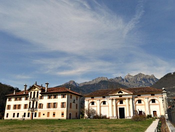
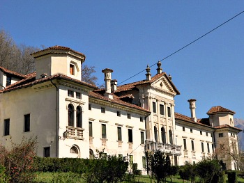
The Culture of Venetian Villas in the Val Belluna
The Venetian villas of the val Belluna were built by and for the local gentry, and represent (in the words of local writer Dino Buzzati) a “happy encounter between the refined spirit of Venice and the silent and rude presence of the mountains” (above, see an image of a Venetian Villa near Arson, nor far from Feltre, set against the majestic backdrop of the Vette Feltrine).
These villas started to be erected at the time of the domination of the “Serenissima (Most Serene) Republic of Venice” as residences for the landowners, who could thus follow closely the agricultural works on their land. The typology used is usually the one codified by the famous architect Palladio for his buildings in the Venetian plains, from which they take inspiration: a central body, flanked by two side wings known as ‘barchesse’ that served as storage, service lodgings and stables.
In many cases, annexed was also a little private chapel, where occasionally notable paintings were kept for private worship – and these are very rarely visible to this day. Elegant gardens with statues and topiary art were another feature – albeit not in all of them.
The added bonus of the villas in the val Belluna – as opposed to their counterparts in the Veneto plains – is that they were often planned in beautiful spots, with the backdrop of majestic mountains.
The elevated number of these buildings may be due to the fact that the plots of land then available were usually quite small, as a numerous population had to try and make a living out of the meagre resources of the traditional economy of the valley.
Despite being rarely erected by famous architects (but there are a few notable exceptions), the level of architectural detail and the quality of decorative cycles in these villas is often stunning, and they present us with a rich artistic heritage that is perhaps their main appeal.
Most of these villas are still privately owned, and for their visit it is usually necessary to contact the owners directly (or sometimes the local tourist offices). This is not the right place where to give a detailed description of these buildings, which are very numerous and especially concentrated around Belluno, Feltre and Sedico, but I will present a brief outline of the main ones.
Particularly noteworthy – just to mention a few – is the cluster of villas gathered in Landris (a hamlet part of the municipality of Sedico), while in nearby Sedico town centre is Villa Patt-De Manzoni, which displays an interesting Italianate garden open to the public, often used for open-air cultural events and concerts during the summer (there is also a Museum dedicated to the Artillery in the villa).
Closer to Belluno is Villa Gaggia, notable for its vast historic garden (80 ha), which was landscaped at the end of the 18th century by the famous landscape architect Poiteau le Terrier, gardener at Versailles; however, this building is also infamously known for the historical meeting between Mussolini and Hitler, which took place here in 1943.
Several hamlets in and around Belluno – such as Salce, Col di Salce, San Fermo and Modolo – present interesting examples of these so-called “ville patrizie” (a rough English translation of which could be ‘stately homes’).
Other notable examples are around Sospirolo, while in Pez di Busche is Villa Tauro alle Centenere, which displays all the typical features of such ornate buildings (and also hosts a via Claudia Augusta milestone that was discovered in nearby Cesiomaggiore in 1786).
On a final, more serene note, in the vicinity of Feltre is the so-called “Colle di Cart” (‘Cart hill’), where there is a majestic historic avenue of old crooked hornbeam trees (these natural features were locally known as carpinete), set among an elegant cluster of old villas (in the closing image below, another elegant example of a Venetian villa in the vicinity of Feltre).
Return from Val Belluna to Belluno
Return from Val Belluna to Italy-Tours-in-Nature
Copyright © 2013 Italy-Tours-in-Nature

New! Comments
Have your say about what you just read! Leave me a comment in the box below.