- Italy Tours Home
- Italy Ethos
- Tours 2023
- Blog
- Contact Us
- Dolomites
- Top 10 Dolomites
- Veneto
- Dolomites Geology
- Dolomiti Bellunesi
- Cortina
- Cadore
- Belluno
- Cansiglio
- Carso
- Carnia
- Sauris
- Friuli
- Trentino
- Ethnographic Museums
- Monte Baldo
- South Tyrol
- Alta Pusteria
- Dobbiaco
- Emilia-Romagna
- Aosta Valley
- Cinque Terre
- Portofino
- Northern Apennines
- Southern Apennines
- Italian Botanical Gardens
- Padua Botanical Garden
- Orchids of Italy
The ‘Grotte del Caglieron’: When Man and Nature Come Together for a Spectacular Show.
General Description
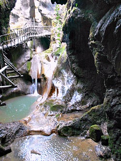
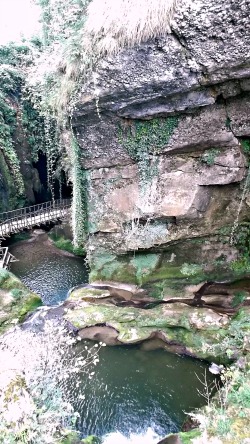
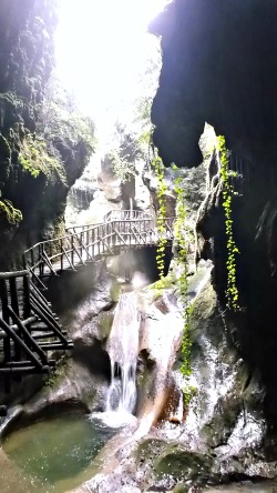
The ‘Grotte del Caglieron’ (Caglieron caves) are situated in the locality of Breda di Fregona, in the province of Treviso. The complex is made of a series of caves, some of which are natural and some of artificial origin; the natural ones are aligned along a deep canyon carved by the Caglieron stream on alternated layers of calcareous conglomerate, sandstone and marl, dating to the Medium (or Middle) Miocene (16 to 10 million years ago). There are also numerous waterfalls – some a few meters high – with large pot-holes at their base. In the deepest part of the canyon (pictured above), one can notice on the walls great calcareous concretions that, for a section, close part of the vault, lending to the complex the aspect of a large cave. On the walls of the canyon wide artificial caves also open up, obtained thanks to the extraction of sandstone – the typical pietra dolza (‘sweet stone’; as it was locally called – that is, soft to the cut). The extraction of this stone – dating back perhaps to the 1500s, or even earlier – provided the raw material that was used for the construction of door and window frames, lintels, etc., which can still be observed today on the old houses and palazzi of Vittorio Veneto and surrounding towns.
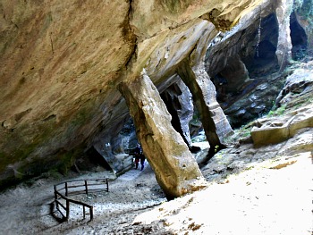
The extraction method that was once practiced is rather interesting too: being the layers inclined well beyond 45°, the detachment of pieces of the material – provoked by using large chisels which have left marks that are still visible – happened by blocks, with the precaution, however, of leaving some inclined columns in place, to support the vault. From this derived a set of suggestive natural caves, distributed along the ravine, on whose bottom runs the swirling and noisy torrent – so much so that this made the construction of an equipped trail necessary.
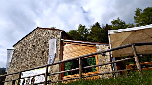
Currently the complex of the ‘Grotte del Caglieron’ is part of the Park of the Grotte del Caglieron, recently refurbished. The starting point of the trail – which is about 1 km long altogether – is situated on the via Ronzon (about 2 km from the centre of Fregona; reachable on foot or by car), just after the newly completed Visitors Centre (see the image below); from there, thanks to a pedestrian boardwalk that crosses the Caglieron stream, one can descend on to a large path, then pass under the bridge of the Provincial road.
Along the trail one meets numerous descriptive panels and, on the right, a very wide cave immediately opens up (‘Grotta dei Breda’), characterised by inclined columns that support the sandstone layers forming the ceiling. A little further on the left, a wooden gangplank leads to the cave (the so-called ‘Grotta di San Lucio’) that is traditionally dedicated to the seasoning of cheese, now being used by the Caseificio Agricansiglio (pictured below; the entry to this cave, as you can notice, is barred by a door). Returning on one’s steps slightly, one then encounters a ‘belvedere’ (viewing platform) – a small terrace in the shape of a ship prow, from which one can observe the splendid natural canyon. Continuing further, one keeps going on the walkway, which in this section runs partly suspended.
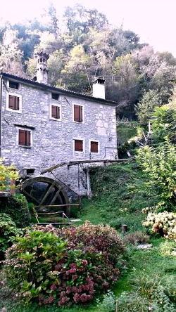
Given the high content in limescale of the water, the latter re-deposits and goes on to create wide surfaces of concretions, with formations of stalactites and stalagmites in the most varied shapes and colours. In the most lit up areas there is a noteworthy presence of travertine, with an alternation of mosses and other vegetal residues. Inside the artificial caves, there are some sections of tunnels that can be explored only by speleologists. Given the constant temperatures in the deepest part of the caves, and the progressively diminishing light, one can observe here a series of micro-environments of noteworthy botanical and zoological interest. At the end of the route in the canyon, the equipped trail takes to an ancient mill that has now been turned into a restaurant and, following the signs on situ, one can proceed by rising towards the bottom end of the park.
Along the trail – which is quite steep to begin with and then flat – one passes two small houses on the right which have been restructured, destined to become the ‘Museo dello Scalpellino’ (stone mason), in memory of this ancient craft. The route ends by exiting directly on the provincial road, almost in front of a cave (‘Grotta di Santa Barbara’), used previously as a space in which to grow mushrooms, and now in the process of being arranged for future use as a didactic laboratory. In actual facts, those that can be visited are just a small portion of the existing caves; some other similar caves are scattered throughout the whole upper part of this area, until the hamlet of Masarè (above the houses known as Borgo Cisei). One of these caves, once passed the bridge above the provincial road, has been dedicated by the local inhabitants to devotion (it has been turned into a shrine, and there is a statue of the Madonna inside).
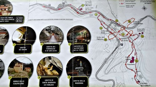
The ‘Grotte del Caglieron’ are appreciated both in the summer for their freshness and in winter for the wonderful ice cascades that form in there; they are also a reference point for workshops on environmental education throughout the year, as well as a popular destination for thousands of visitors. The caves are open all year round and the visit is free, except in case of extreme weather, when the site can be closed without much notice for safety reasons – in any case, it is always better to check before visiting (in the picture below, a partial reproduction of the map with the route of the nature trail within the Park of the Grotte del Caglieron).
Noteworthy Fauna of the Caglieron
It is almost an impossible task to describe all the terrestrial and aquatic fauna that gravitates around the ‘Grotte del Caglieron’, for the noteworthy variety of species present. Let us remember that the area is located at the foothill of the Cansiglio plateau, from which stray (descending or ascending, according to season) the herbivores and the small carnivores that can find here shelter and a chance to dig their dens and furrows – sometimes even inside the abandoned quarries. A similar consideration must be done for the westerly-easterly corridor; that is, along the ‘corde’ or ‘coste’ (‘ribs’) that continue towards the Vallata on one side and Friuli on the other. Let us not forget, also, that the whole region at the foot of the Eastern Alps is an important area of passage for migratory birds, favoured by the morphology of the terrain, which heats up the air thus provoking ascending currents (the so-called ‘thermals’) that the birds know how to exploit all too well. Therefore, we will briefly illustrate the most interesting species that can be discovered and observed here.
Birds
White-throated Dipper (Cinclus cinclus). This bird reminds, for its dimensions, of a blackbird, but its build is more compact, with a short toe and an unmistakable white ‘stain’ between throat and breast. It is strictly connected to the flowing water of mountain and hillside streams, from which it never strays too far. It prefers limpid and clean waters, into which it immerses itself, moving along the bottom with the help of short wings, like a penguin; it searches for larvae of invertebrates, small fishes, mollusks and crustaceans. The plumage is completely impermeable thanks to a gland that produces abundant fat, which the bird then distributes on its body with its beak. This species indicates with its presence an optimal situation as regards to the quality of the water, with an abundance of invertebrates. It is present in the whole upper section of the Rio Carron and in the area of the Caglieron stream itself, where it nests even in the niches under the bridge’s arches. It is a well visible bird, when it rests on stones in the middle of the currents.
Fish
European Bullhead (Cottus gobio). It is a small fish that lives at the bottom of the rivers; it is mimetic, with reserved habits, maximum 15 cm long. Its typical habitat is the rocky bottom of streams, torrents and not very steep rivers with fresh, limpid, oxygenated, unpolluted waters. It chases larvae and invertebrates, especially at night; it also ambushes small fishes and it is, in turn, the typical prey of Brown Trout (Salmo trutta morpha fario). During April and May, the male digs a furrow under a stone, where it invites – after an elaborate courtship – the female to lay the eggs, which he then defends strenuously after fecundating them. The European bullhead has become rather rare as – more than any other fish – it is particularly sensitive to water pollution; it is still present in the upper section of the Carron stream, and protected by law.
Amphibian
Fire Salamander (Salamandra salamandra). This large tailed amphibian, up to 25 cm long, is typical for the shiny outlook of its skin, black with large yellow spots. It is a slow animal, which moves in the undergrowth at night or in very humid days. It does not fear predators as its skin is dotted with glands that exude a poisonous and irritating substance. Like all other amphibians, it is strictly dependent on water for reproduction: the female – ovoviviparous – deposits in torrents and streams light brown larvae, 1-2 cm long and with external gills that, after a few months, undergo a transformation (the gills and the dorsal fin disappear; lungs develop); the animal can then move on to terrestrial life.
Invertebrate Life
European Crayfish (Astacus astacus). It is an invertebrate endowed with a leathery external skeleton and two long antennae; it has five pairs of legs, of which the first few are transformed into claws (‘chelae’); part of the abdomen terminates with a fin. It has a maximum length of 15 cm, and is of an olive green colour. This animal leads an aquatic life, passing the daylight hours hidden in shelters under the stones or dug into the stream banks. At night, it behaves like a predator and chases small fishes, tadpoles, larvae, invertebrates, eggs – but often makes do with dead animals and vegetal matter from plants. It has disappeared from many rivers because of pollution, and is now a species protected by law. The Carron stream – north of Fregona – and the head of little, local brooks are typical habitats for this species, which is also an indicator of the good quality of water.
Niphargus. It is the name of a small crustacean (more precisely, a freshwater amphipod), often known with the name of cave shrimp; it is very similar to water shrimp, or Gammarus. Both are in fact amphipod creatures, from a few mm to 4 cm long, and they have the unmistakable characteristic of swimming on their side. While Gammarus can be found in all non-polluted brooks and streams, Niphargus have colonised the underground waters, and are present in almost all of the caves. It is difficult to spot them, however, for the transparency of their tissues, and also as they tend to flee from the sources of artificial light (as, for instance, when speleologists enter the caves). They are in fact blind, de-pigmented, and have long antennae that they use to orient themselves and to find food, which consists mainly of remains of organic matter and bacteria. They also dig furrows, in which they take shelter in order to escape from predators or sudden changes in water levels. They have a very slow metabolism, and can live to up to 15 years. Inside the ‘Grotte del Caglieron’ these crustaceans can be observed in those pools of water not reached by daylight. The specimens that have been found here are about 1,5 cm long and are still in the process of being studied; they constitute an important biological entity that contributes to further enrich the environment of the ‘Grotte del Caglieron’.
The Vegetation of the Caglieron
The Profile of the Valley
The ravine formed by the Caglieron stream has a typical ‘V-profile’, characteristic of valleys with fluvial erosion; the geological substrate is given essentially by powerful marl-sandstone layers. The soil in which sinks its roots the vegetation of trees and shrubs is rather superficial, with a neutral pH (about 7) for the strong influence exercised by the substrate, rich in rock detritus and with a prevalent lime/sand-based texture, generally well endowed in organic matter. This is because of the slowness with which decomposition takes place here, for the presence of prolonged drought periods during the summer months, connected to the noticeable drainage of the terrain (a physiological – but not climatic – aridity, given that rainfall in the area averages around 1,700 mm/year).
The Ferns of the Caglieron
In the basal area of the Caglieron stream, in correspondence to the homonymous caves, one can encounter extensive formations of ferns in the undergrowth, dominated by Hart’s-tongue Fern (Phyllitis scolopendrium). Besides this, one can also notice Maidenhair Spleenwort (Asplenium trichomanes) and, on a more curious note, Fortune's Cyrtomium (Cyrtomium fortunei). The latter is an exotic fern, whose aerial is extended from eastern China to Korea and Japan. Used as an ornamental species, it has escaped cultivation and has become naturalised on damp, shady rocks in some areas of northern Italy (for instance, on the Monte di Ragogna and around Budoia in Friuli; in the Canton Ticino in Switzerland, and at Cannobio on Lake Maggiore); it is the first time, however, that this plant is being reported at the Caglieron – and therefore, by extension, in the Veneto. Ferns, in general, are favoured by the particular micro-climatic conditions that are being found in proximity of the caves, where the valley of the Caglieron stream takes on the aspect of a canyon. In such a geo-morphologic context – both for the valley’s orientation, and for its narrowness – one finds as a consequence a fresh, humid and scarcely lit valley floor: conditions that are ideal for the development of ferns, which are in fact growing abundantly in this location (above, see a picture of the canyon, in the section where it is most covered in ferns and mosses; notice also the pot-holes caused by water erosion – a phenomenon which will be better explained further on).
The Wood Formations and the Vegetation
In similar conditions, the most typical forest formation to settle is the ‘Ostryo-fagetum’. The main species that compose it are Manna Ash (Fraxinus ornus) and Hop Hornbeam (Ostrya carpinifolia), while Pubescent Oak (Quercus pubescens) participates in a rather more sporadic way, as do Mountain Laburnum (Laburnum anagyroides) and Whitebeam (Sorbus aria); in the shrub layer, instead, are frequently encountered Hawthorn (Crataegus monogyna), Hazel (Corylus avellana) and Common Juniper (Juniperus communis). In the herbaceous layer – well represented, given that the sparse tree canopies allow for a certain amount of light to reach the undergrowth – one can observe species typical of dry habitats such as Heather (Erica carnea) and the widespread Moor Grass (Sesleria albicans). On the hydrographic right side of the valley, before the canyon begins, one can also notice a few Birch trees (Betula alba) and some specimens of Scots’ Pine (Pinus sylvestris) that betray different environmental conditions: fresher and with more availability of water – witnessed, after all, also by the herbaceous species that are present. In fact, one can notice here the conspicuos presence of tufts of Purple Moor-grass (Molinia arundinacea) – a member of the Graminaceae family typical of damp soils; sporadically, Tofieldia calyculata is visible too. To be reported, also – on the hydrographic right side of the canyon – is the presence of a specimen of yew tree (Taxus baccata), still relatively young and growing near a beech: species that are both good indicators of the conditions of high humidity found in the canyon.
At the entrance of the caves, wherever a minimal accumulation of eroded material constitutes a suitable substrate, and up until the point where enough light for the photosynthetic activity to take place filters through, one can frequently find populations of bryophytes (mosses belonging to different species and liverworts), in association with Maidenhair Fern (Adiantum capillus-veneris), which covers the rock wall at the exit of the natural cave down-river almost completely.
The Complex of the ‘Grotte del Caglieron’
It is a complex of caves that can be seen in the locality of Breda (municipality of Fregona). Overall, these cavities are called ‘caves’ even though, more correctly, in the area can be seen:
– some open-air caves;
– some subterranean caves (about 30);
– some of the subterranean caves are natural and part of the ravine;
– some of the caves are intersected by the enlargement of the quarries.
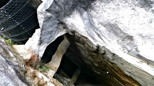
Locally, the all these are indiscriminately called ‘caves’ (grotte), and even in the boards that illustrate the didactic route they are all called either ‘cavities’ or natural caves. The ‘Grotte del Caglieron’ are found for the most part in a deep ravine – incised by the torrent bearing the same name – within sandstone, marl and rarer conglomerate layers (the latter, dating to the Middle Miocene). Given the noticeable steepness of the riverbed, the waters form a few small cascades – some of them several meters tall, and often with large pot-holes at their base. In the deepest part of the ravine one can also notice on the walls rather extensive, impure limestone (calcareous) concretions that partially ‘close’ the vault, giving the whole complex the aspect of a real, ‘proper’ cave.
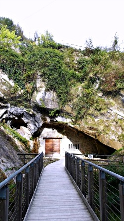
On the walls of the ravine two large artificial caves – also known as ‘grotte’ – open up: they were obtained by extracting sandstone; better known here as pietra dolza, ’sweet stone’, as it was so easy to work. The extraction activity – that dates back to the 1500s, and perhaps even earlier – provided the material for the building of door and window frames, lintels, etc., which can still be observed today on the old houses and palazzi of Vittorio Veneto and surrounding towns. The extraction method was rather interesting too: being the layers inclined well beyond 45°, the detachment of pieces of the material – practiced with particular small pick-axes known as ‘magli’, which have left grooves that are still visible – was executed by cutting blocks or parallelepiped shapes, with the precaution, however, to leave some of the inclined columns in situ, in order to support the vault (pictured above is the gangplank route, in the section that runs under the former quarries). A particularly suggestive set of caves – distributed along the ravine – was thus derived, on whose bottom runs a swirling and noisy torrent, so that the area can be enjoyed from the point of view of tourism too.
The route that has been devised runs at first above the waterfalls and pot-holes, passes inside the great natural cave, then returns to broad daylight and arrives at an ancient and picturesque watermill dating to the 16th century, which exploited precisely the water power from the stream, but has now been converted into a characteristic inn (or ‘osteria’; see image below). The area has a noticeable naturalistic interest as well: one can observe here the already mentioned sandstone, marl and conglomerate layers; noteworthy is also the fluvial morphology, with erosion shapes that display waterfalls and pot-holes, sometimes of a certain dimension. Inside the larger cavities there are often water drippings and small waterfalls that, thanks to the high limescale content, originate some beautiful concretions; besides, one can also observe typical deposits of ancient travertine, partly still in the process of being formed. In these low water tables it is not at all uncommon to find some small specimens of Niphargus – which are typically blind, de-pigmented crustaceans that populate the underground waters (described above).
The vegetation in the ravine and in the surrounding area is rather characteristic as, from a climatic point of view, one passes progressively from a south-facing aspect – therefore bare and arid – to areas exposed to the north (or sunken), which are on the contrary rather damp. At the bottom of the ravine the light progressively diminishes; therefore, the various vegetational bands are characterised by the progressive disappearance of – at first – the phanerogamous plants, then of the ferns, the mosses, the lichens and the unicellular algae. In this location, two small springs of sulphureous water are interesting to observe too. Noteworthy is also the didactic interest that these caves represent for the concentration of so many different features within such a small area: geo-morphology, vegetation, and the forms connected with man over time for the exploitation of the pietra dolza (this process is explained in more detail below).
Industrial Archaeology: the Extraction of the pietra dolza
Memory of the first extraction on the part of the ‘scalpellini’ (stone cutters: thus were defined those who worked the stone – and not ‘cavatori’, miners) that used the pietra dolza are lost in the night of time. Some suppose that the Romans were already exploiting the quarry, but there are neither material evidence nor bibliographic traces to support that hypothesis. Towards the 1500s the quarries provided material for the building of door and window frames, lintels, cornerstones, coverings, steps, mouldings, cornices, etc. – as it can still be observed today on the old houses and palazzi of the two old towns of Serravalle and Ceneda (now jointly forming Vittorio Veneto), some houses in the surrounding hamlets of Sonego and Breda, and – above all – a few buildings in the town of Fregona, the municipality where the ‘grotte’ themselves are located. In this latter location, the church and the bell tower are built in pietra dolza and turchino – a limestone rich in marl that was extracted at the nearby caves of Ciser.
Since then, extraction continued unabated through to the 1950s, and it is likely that – on the basis of notions passed on orally – it was mostly families from Sonego and Breda who dedicated themselves for centuries to that difficult and tiresome activity; amongst them are remembered especially the families of the Breda, who lived precisely in Borgo Breda, the Gambin and the Dei Tos (known as ‘guardiani’, watchmen). Today these stones are sporadically still being extracted – or rather used for restoration works. The pietra dolza, which lithologically can be defined a sandstone – that is, a cemented siliceous sand, held together by limestone and clay in variable proportions – in reality is subdivided by the ‘scalpellini’ into three groups according to its characteristics: a softer type of pietra dolza, a harder type, and the ‘medolaz’, which as the name suggests has intermediate features (‘medo’ = middle). Naturally, each type of stone also had its characteristic uses.
Rocky Outcrops and Excavation Techniques
As already anticipated earlier, in the area of the ‘Grotte of Caglieron’ – and along the whole ‘Costa di Fregona’ – come to the fore alternating layers of such materials, often interposed with smaller layers of cemented gravels that constituted a huge problem for the ‘cavatori’, this being material which could not be used (and would even disturbe the extraction activities). In such instances, it was necessary to follow the ‘good’ vein – that is, the layer that would be inclined, sometimes, well beyond 45° – inside the rock; the removal of the material took place in a progressive way along the layer, both horizontally and by following the layer towards the bottom. In this way, galleries several meters long would be dug, interrupted only by inclined columns, obtained by leaving some of the rock material in place, perpendicular to the layer and with the function of supporting the vault (another image to show this peculiar effect is displayed below, in a picture referred to the Grotta di Santa Barbara). This extraction technique is characteristic to all quarries in the area, and it is usually not being found in other similar situations. It is incredible that vast subterranean environments have been obtained with such a simple technique and a very reduced number of tools (usually less than five) – a fact which is matched only by the striking knowledge of the rock structure as well as an exceptional, intelligent extraction technique, result of centuries-old experience.
Extraction of the Pieces.
To begin with, the right type of rock was being chosen – according to the use that was envisaged –; then, in function of the desired length, the spots were searched in the various quarries where that piece could be obtained, starting from a vertical fracture or a previous detachment of material, in such a way that the length of the artefact could be established beforehand. If, for example, one wanted to extract a parallelepiped-shaped piece for a lintel or a door frame, work would start from the top, and – with a small and very sharp pick-axe – the rock would be incised horizontally, starting from a fracture that, like the others, here is normally vertical; always along the same layer, further down, an incision parallel to the first – and always with the same tool (a mallet) – would then be made, so that width and length of the two incisions would correspond respectively to the length and width of the future artefact. In this way, the grooves were thus deepened – with the help of a pick-axe – until reaching a depth that corresponded to the thickness of the object one wanted to obtain. Then, steel blades known as ‘biete’ were put down into the groove, on top of each other, until filling up the groove; for every ‘pack’ of three-five ‘biete’, two steel cones (‘cugni’) were also inserted; close to the first group of these blades one would then put another ‘bieta’ with two ‘cugni’ – and this for the whole width, so that the blades would be side by side. This applied to the upper groove, while the lower one was left free. Then, with a large steel hammer, all the cones were hit repeatedly, one after the other, starting from one extremity and then going along the length of the vein; when the other extremity was reached, work would then start anew: this procedure could continue for quite some time, until – with a sharp stroke – the piece would come off the wall rather abruptly. The strokes of the mallet would thus leave some parallel, slightly curved traces on the walls, which are still visible to this day; then, the raw pieces extracted could be further shortened and made smaller, depending on the envisaged use, with other more laborious techniques that will not be described here, and then refined.
Other Materials that Were Obtained from the Site.
As already anticipated before, in the caves – or rather quarries – one could find residual material that was then being used for the making of small walls and other minute building work; besides, the sand that resulted from the alteration of sandstone was used as an ancient ‘detergent’. In fact, in all the houses of the time there was the so-called ‘ran’ (a set of pans, ‘caliere’, water recipients, wooden spoons and other kitchen tools) made out of copper; the cleaning of copper (or, rather, one should say the polishing – as copper would oxidise quite quickly) was achieved with the so-called ‘salvame’: that is, the sand that was obtained from the alteration of the pietra dolza. As said earlier already, even the interpositions within the conglomerate – as long as they had a certain thickness – could be used: from them, millstones with which to grind corn were obtained; in fact, one can still see, in some points, a few niches from where the millstones were extracted, or even the attempts at extraction; the millstones would then be just etched, and left in situ.
Most of the information that has been collected here is the result of interviews with local people and former quarry workers – in particular Mr. Arturo Breda, who we wish to thank: a descendant of the many generations of ‘scalpellini’ that lived in the area and skilfully worked the pietra dolza, as well as a precious conservator of the local historic memory.
The Evolution of the Landscape
The history of the landscape that surrounds the Caglieron area is relatively ancient, and it starts about 180 million years ago, in the Lower Jurassic, when this region was occupied by a rather shallow sea. After that, there followed a slow sinking of the sea bottom, which protracted itself for the whole length of the Jurassic in the western section, while to the east there continued to be shallow sea conditions which remained unchanged also for all the following Cretaceous period, from 135 to 65 million years ago.
During that period, the paleo-geographic situation was such: an area of high plateau (‘Carnian Plateau’) extended to the N of the Caglieron; an area of passage linked it up with a shallow sea with coral reefs and lagoons (the ‘Friuli Platform’) to the E and SE; an area where the sea got progressively deeper (‘Belluno Basin’) was to the W and NW. The various types of rocks deposited during this period allow to identify a proper “reef complex”. The reef developed mostly on the massif of the Cansiglio-Monte Cavallo system, then continued eastwards to Friuli, the Carso region near Trieste and beyond; in our area, one can see the remains of such reef in the direction Cansiglio-(Crosetta-Candaglia)-Monte Cavallo-Monte Raut.
Towards the end of the Cretaceous, the sea bottom deepened; there were also some turbid currents, therefore the reef came to die down, and an earth sediment was deposited above, which subsequently transformed into marly limestone with a rather thin grain, nodules and little flint layers of different colours, from reddish to grey, known as ‘scaglia’ (scale): this rock denotes the passage to the Tertiary era, which began 65 million years ago. During the Tertiary – and more precisely in the Lower Miocene, 26 million years ago – a marine ingression took place, with the deposition of a succession of clays, sandstone, marl, calcarenite and conglomerate, often alternated: this formation goes under the name of ‘molasses’, which can be found just to the north of the area of the Caglieron. These rocks are similar to those of the Medium-Upper Miocene that will be described in more detail later, when illustrating lithology.
Towards the end of the Miocene started the emergence from the sea of the Cansiglio-Monte Cavallo mountain group – as well as of the Cesen-Visentin chain – with the deposition of conglomerate (rocks containing pebbles and gravel, cemented by a calcareous matrix), due to the dissolution of the rocks prompted by atmospheric agents; these rocks can be found to the south of the Caglieron area. The uplifting was caused by the compression and rise due to the enormous pushes coming from sideways, from the S-SE towards the N-NW (or SE⟶NW), connected to the prosecution of the movement of the African plate towards the European plate.
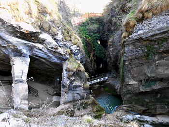
These thrusts made the rocks bend in a series of great folds, and in some cases there was even an overlap – as it most likely happened at the southernmost fringes of the Cansiglio plateau. In the area of the Caglieron, the aforementioned thrusts caused the inclination of the layers, prompting also their immersion towards the SE – as indeed can be observed inside and outside the caves. Even water was conditioned by this stratigraphic situation; therefore it followed the maximum inclination of the layers, presumably being channeled along some fracture – and thus the Caglieron ravine was created, which has a prevailing NW⟶SE direction (the ravine is pictured in an atmospheric image below, where the typical pot-holes caused by water erosion are also visible). This phenomenon continues today, even though with less intensity: proof of that is the relatively high seismic activity and the earthquakes that still affect, from time to time, the area around Vittorio Veneto and the Cansiglio-Monte Cavallo mountain group.
During the Quaternary (last two million years) cold and warm periods alternated, which provoked the formation of an extensive icecap, even at our latitudes. The Alps – including the Dolomites – during the coldest periods were covered by extensive glacial surfaces that averaged or even exceeded altitudes of 2,000 metres, while to the south – towards the plains – the ice sheet became progressively thinner, dividing itself into many smaller glaciers that followed the main valleys as it went along. In our area, of great importance was the Piave ice sheet: it descended along what is currently the valley of the river Piave and then it divided itself into two branches, roughly in correspondence to where today lies the town of Ponte nelle Alpi: the main branch veered to the right and occupied the whole of the val Belluna (Belluno branch); the lesser branch curved to the left, and part of it expanded over the Alpago region, while another part descended along the so-called val Lapisina (Lapisina branch).
The glacier skirted – at the beginning of the val Lapisina – the altitude of 1,200 metres; along this valley, the glacier eroded the mountain walls, removing detritus, and dug on the valley floor some hollows that would later become small lakes, still existing to this day (Lago Morto, del Restello and Negrisiola). Just upstream from Serravalle (Vittorio Veneto) – where in the period of maximum expansion during the last Glaciations the glacier had a thickness of about 600 metres – the Piave ice-sheet divided again into two branches: the first veered westwards and went through the Vallata; the other branch went beyond the Tertiary hills and expanded over the plains in the guise of an amphitheatre. It thus reached as far as the current towns of Colle Umberto and San Fior, where it deposited material known as ‘moraine’, which later took the shape of stretched out hills, (‘corde’) thus giving origin to the so-called Vittorio Veneto moraine amphitheatre ('Anfiteatro morenico di Vittorio Veneto').
Thanks to the ‘Costa di Fregona’ – on which we can find moraine detritus and also some ‘moraine arches’ – the area of the caves was rather protected by the glacial action, therefore we do not find typical glacier morphologies here. From the steep southern slopes of the Cansiglio plateau the meteoric waters have incised and removed detritus material, which has then been deposited further down the valley, joining up with the plains and thus forming a series of ‘conoids’ (fans), relatively flat, over which lie the town of Fregona and the hamlets of Sonego, Breda and Ciser.
These settlements are separated by deep cuts and traversed by several water courses, amongst which are the Carron and Caglieron streams; in them, where marl mostly resurfaces, landslides often happen. Where sandstone and conglomerate are exposed instead – as these rocks are more resistant to atmospheric agents – one finds the formation of long, low, parallel hills that are a peculiarity in the whole area of the Prealpi Trevigiane. These ridges (also known as ‘corde’) extend towards the W-SW in the so-called Vallata and beyond, all the way to the Vicenza province, and – in the other direction, towards E-NE – in Friuli. In the Caglieron area, the most noticeable ‘corde’ are the ‘Costa di Fregona’ – where the whole complex of the caves develops – and the ‘Costa di Serravalle’, further to the north.
Lithology (Geological Information)
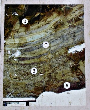
In the area inside which the caves are located, emerge rocks of the Tertiary period that have an age comprised between the Mid-Miocene (Tortonian) and the Upper Miocene (Pontic) periods; that is, from around 18 to 7 million years ago. The rocks of the Tortonian, more ancient, are constituted by an alternation of marly clay, sandy clay, sand and sandstone with calcareous cement and intercalations of conglomerate nodules; numerous are also the fossils that can be found in such settings, including bivalves, gastropods and sea urchins, typical of a rather shallow marine environment. The rocks of the Pontic, more recent, comprise alternations of various kinds of conglomerate, with limestone and sandstone nodules containing gastropods (Helix sp.) and lignite nodules, typical of a lacustrine or Delta environment. For example, in cave number 1, at the entrance – especially in winter, when less concealed by the vegetation – are recognisable, from the lower layers going upwards: a layer of grey marl (A); a conglomerate layer (B); alternations of prevailing sandstones and some layers of grey marl (C); the series is closed at the top by more resistant banks of sandstone (D) (the letters refer to the picture taken directly from the explicative boards on site, which you can check below).
Erosive Morphology Traits of the Caglieron Ravine
The current form of the natural caves – but most of all of the ravine proper (that is, the canyon where the Caglieron stream runs) – is linked to the mechanical action and the chemical dissolution of water. We know that running water transports suspended material (sand, clay), while the heavier materials – such as coarser sands, pebbles and gravels – roll down, depending on the speed of the water (that is, its energy). Transportation of the above material, added to the strength of the water, provokes an abrasive action (like sandpaper) that results in the removal of material; naturally, this action varies depending on the resistance, fracturing and composition of the rocks. In addition, there is a strict relation between the diameter of the particles of sand, gravel and pebbles and the energy of the water, which is strictly correlated to its speed. One can thus understand how, at a certain speed of the water, corresponds a transportation towards the bottom of material with a clearly defined diameter; to a smaller diameter corresponds rather a transportation in suspension of the different particles, while the stones with a major diameter remain directly stuck at the bottom.
If we apply these considerations to the waters of the Caglieron stream, where there are several inclined and fractured layers – and especially some that offer different degrees of resistance – one can thus understand how the softer rocks will be more easily transported in comparison to the harder ones. Along the bed, therefore, some hollows would progressively form within the softer rocks, limited towards the upper and the lower valley by inceptions of harder rocks (as it can for instance be observed above the first waterfall, as one goes down). Subsequently, the hollows would expand while the inceptions less so, thus originating further waterfalls. At the base of each waterfall, thanks to the vortical action of water and the abrasion caused by the transported material, semi-spheric cavities would progressively be carved; these clearly recall in form the ‘cagliere’ – large copper pans where once polenta or cheese would be prepared: it is therefore likely that the name of the torrent (and of the caves), Caglieron, originates from this.
These hollows are still known as ‘marmitte’ (pot-holes) in Italian, and along the ravine one can observe several of them, with different morphologies. In some of them, it is also possible to glimpse large, almost perfectly round pebbles at the bottom: in the occasion of heavy precipitations, it is likely that the violence of the running water can make them roll at the bottom and against the walls, thus enhancing erosion, with the result of enlarging the pot-holes and also make the pebbles (that have been moved around) rounder. The above mentioned actions translate, in time, into a progressive deepening of the ravine, which is more pronounced in those sections where the stream bed is more inclined (and the water currents stronger) and less pronounced where the stream bed is less steep. All this results in a progressive adjustment of the stream’s bed, with the subsequent characteristic concave profile along the whole watercourse, more inclined in the upper section and less so in the lower section, unless – as in our case – some weirs are put into place. These interrupt the natural evolution of the profile, but in time they also tend to form a series of minor concave profiles, of different length, between weir and weir.
Karst Morphology of the Caglieron Caves
The rocks that surface in the Caglieron area are formed for the most part of siliceous sand, cemented by calcium carbonate; that is, by limestone, on which karst phenomena notoriously operate. A brief explanation follows: carbonate rocks (calcite, aragonite, Dolomite, sandstone) are not soluble in pure water, but they can be dissolved by the presence of water if mixed with carbon dioxide (present in the air) that transforms calcium carbonate (limestone) – which is insoluble – into calcium bi-carbonate, which is soluble. The solvent action of water from rainfall is exercised in the first place on the surface rocks, where it produces a great variety of shapes, larger or smaller, such as doline (sink-holes), furrows and ridged fields that create a rather characteristic landscape – known precisely as karst landscape. As rainfall infiltrates also below ground through the cracks and the pores, then dissolution of the rocks propagates in depth where it can give shape to fairy-tales environments such are the caves. The dissolution is not simply question of a chemical reaction between water, carbon dioxide and calcite, but it is in reality expression of quite a complicated chemical balance: it is enough for temperature to vary a little to make carbon dioxide in the subterranean caves evaporate, or for variations in the other factors (these will not be described here for the sake of simplicity) for the bi-carbonate to revert to calcium carbonate; in that case, it will be deposited on the rock walls following the rules of mineral crystallography, and it will give rise to those incredibly suggestive, extravagant forms that we all know as calcareous concretions and deposits.
Along the route on the gangplank above the Caglieron stream – especially on the hydrographic right side of the caves – it is possible to notice some beautiful but rather impure concretions of a greyish colour: these are either deposits of ancient concretions or formations in the process of being shaped right now that, thanks to the presence of light, are of support to algae and bacteria, which give them this aspect and coloration. But even inside the caves one can in fact see the deposition of limescale; an example that deserves a visit is at the bottom of the first quarry; the one we can see while descending on the hydrographic left (the cavity known as no. 4): given the morphology of the uniform but inclined ceiling, the little percolation of water that there is passes through the fractures in the rock, thus enriching itself in limescale – or condensing it – and then it deposits on all the rock walls, which creates an extraordinary scenic effect, constituted by long parallel ‘brushstrokes’; the slight variations in the tones of colour that can be detected depend in fact on the small mineralogical differences carried by the salts that have deposited here.
When the cave floor is horizontal and subject to water drippings, limescale is being deposited around sand granules, giving shape to little calcite spheres known as ‘cave pearls’. Another phenomenon linked to the re-deposition of limescale is the formation of travertine. Along the gangplank, in front of the greyish concretions, one can notice a rock wall completely covered in moss, over which water percolates abundantly. Progressively, limescale is being deposited on the moss until covering it completely, thus obstructing the alveoli (small cavities) within the thick layer of moss; from this results a calcareous, spongy stone, not very resistant, which is precisely called travertine. It is a very important rock on this site, as it can be found only in small nuclei here and there along the ravine, and can give us precious information on the canyon's deepening, on the ancient water percolation – on the evolution of the site itself, in fact. In the various waterfalls inside the caves, thanks to the high amount of limescale in the water, anything that comes into contact with it – or that is immersed in it – is quickly covered by hard deposits of micro-crystalline limescale; that is, of calcite, as it can indeed be appreciated, for example, at the entrance of cave no. 1.
Natural Evoution and Tectonics of the Caglieron Ravine
By observing the running water, without apparent changes in the shape of the ravine to happen, a question naturally arises: is there a transformation in this peculiar landscape; or rather, what has its evolution been? The answer is affirmative: there has been a transformation, and we can try to provide an explanation by starting from a few thousand years ago. It is likely – as it was already anticipated in the reconstruction of the landscape evolution – that the meteoric waters were channeled along the line of maximum inclination of the layers that immersed towards the SE, perhaps following fractures with a NW-SE direction, which is a dominant feature in the tectonics of this area. We should also be reminded of the fact that composition of the local rock is mostly constituted of sandstone and marl with calcareous cement and, more rarely, conglomerate. It was thus subjected to removal by mechanic way (erosion) at surface level but also to chemical dissolution (karst), especially at deeper levels, with a progressive widening of the small cavities that formed along the fractures and in the gaps between the rock layers.
With the passing of time, there has been an evolution from a superficial circulation of water to a deeper circulation, thanks also to the progressive extension of a sink-hole (probably located just down-river from the stone bridge) into which water would enter; it then travelled a subterranean section, coming to daylight roughly in correspondence to where the old watermill is situated; incidentally, from this derived the abandonment of the entry point (sink-hole) of the ancient riverbed downstream, where superficial running water would flow. The deepening of the subterranean canyon has attracted other watercourses that were flowing along the fractures and between the rock layers, thus establishing a subterranean water circulation system (karst), with typical phenomena of dissolution, erosion and the formation of concretions.
An example of conservation of this phase can be found in cave number 1, where – on its bottom, towards the SW – a small spring can be observed, emerging along a fracture; besides, near the entrance to the left, there is a rather abundant waterfall gushing forth from a cave that develops along the rise; this cave has been explored by speleologists for about 20 meters, and it shows concretions inside. The water has continued to dig and deepen the pot-holes along the whole route, both below and above ground. The atmospheric agents have then contributed to widen the sink-hole wall down-river, and this caused the regression towards the mountainside of the exiting cave’s wall: the result of the two opposite actions has shaped the natural arch under which has been built the gangplank route, and where the Nature trail also passes.
On the ravine wall, thanks to the percolation of water and the reduced light amounts, over time have installed themselves noteworthy colonies of mosses and lichens that – thanks to the waters very rich in limescale – have also given origin to deposits of travertine. At the moment, it is possible to witness the formation of a noticeable amount of travertine on the hydrographic left side of the canyon, where light is able to arrive, and there are abundant water drippings. To be noticed, too – in front of the above mentioned travertine deposit – is the deposition of limescale, with beautiful rock concretions of a greyish colour, due to the little amount of light that manages to penetrate here, which is not sufficient for the development of mosses; the concretions then continue in all of the subterranean section of the cave ‘proper’, until the exit of the cave itself.
The Action of Meteoric Water
It is a well known fact that meteoric water is almost pure, but when it precipitates, as it crosses the air, it becomes enriched of atmospheric fine dusts and whatever else it might meet along its journey. Besides, water reacts with different gases that are found in the atmosphere or that compose the air – product, most of all, of volcanic gases or of combustion in general, etc (one could be reminded, in this respect, of the acid rains and also the P10 pollution of these latter years). When it penetrates in the ground, meteoric water mixes up with the humid acids produced by the plants' root systems and the decomposition of vegetal matter; subsequently, it enters the depths, either through cracks in the rocks or because of porosity, taking a convoluted route that it can take a long time to travel. Obviously, as it flows in close contact with the rock, water slowly dissolves the latter, and therefore it becomes progressively enriched with all those substances – mineral, for the greatest part – that form the rocks. It is enough to read a label of any bottle of mineral water to verify this fact, and it is to be noticed that just a small part of the minerals present in the water are usually being reported.
When water finally resurfaces – either from a spring through cracks in the rocks, or over the plains in the form of a ‘risorgiva’; phenomena that are well known in these areas (explained below*) – it carries with it a ‘memory’ of the vicissitudes it has been going through since it fell from the sky and during its passage underground, all the way to the spring. This ‘memory’ is constituted by the physical characteristics and the chemical elements picked up along the way: those studying hydrology know this fact all too well, as they are able to tell everything about a certain water after examining it. And so, what about the sulphureous water springs in the Caglieron area? For them, the same considerations made above apply – so let us try to explain better what happens.
The waters here cross rocks mostly made of marl and clay, typical of a lagoon-like or lacustrine environment (from a geological point of view); these types of soils are rich in decomposing organic matter, and give out compounds such as nitrates, sulphates, and other – sometimes also gassy – substances. These volatile chemical components are being taken away by the water, and when they are concentrated, we perceive – as at the source here – the typical smell of ‘rotten eggs’, mostly due to the presence of gas compounds derived from sulphates. Even the taste of water is influenced by this, and it can become rather unpleasant; however, these waters have proven to contain certain curative properties too. The substances which are dissolved can in turn be ‘food’ or nourishment for the very simple but resilient life forms that live in this particular water: if we look attentively, we will notice some filaments similar to algae, moved by the currents, and also a whitish veil that covers the sediments lying at the bottom. If we were to put this veil on a glass slide and observe it with a good microscope, we would see that it is constituted by characteristic bacteria called sulpha-bacteria, together with green and blue algae, ciliate protozoa, diatoms and other unicellular beings that feed precisely on these filaments, linked together in a most peculiar food chain. However, the spring that is being referred to here (as well as on the boards on site), which gushes forth along the right bank of the Caglieron stream, is not the only one: just a few metres away, by going upstream along the left bank – but almost at the same level of the stream bed – another spring has formed more recently (known as ‘Sorgente della Uaua’), which displays analogous characteristics to the one just described (below, another image of the Caglieron ravine, taken from above; some of the pot-holes caused by water erosion are well visible in the picture).
(*) A risorgiva, or fontanile, is a freshwater spring of natural origin, sometimes forced by man, typical of alluvial soils in many parts of the Upper Po valley, including the Veneto and Friuli. Use of the term risorgiva, in fact, is correct only when the surfacing of water is spontaneous, while it would be more proper to employ the term fontanile when the spring is of anthropic origin. The overlapping – and sometimes confusion – between the two terms derives precisely from the fact that often the fontanili were being excavated in areas already affected by risorgive. The fontanili or risorgive are also characterised by a typical flora and fauna, as indeed can be appreciated – for example – at the Sorgenti del Sile: a nature reserve about 25 km from Treviso, and not far from the Caglieron site.
The Cansiglio Forest
General Characteristics
The Cansiglio plateau is delimited to the SW by Monte Pizzoc (1,565 m). From the summit of Monte Pizzoc, the panorama that opens up is very vast, and – in clear days – it roams at 360° from the Venetian plains all the way to the sea; on the other side, looking towards the mountains, it sweeps from the Cansiglio plateau to Monte Cavallo (2,251 m) and beyond – to the Julian Alps in the background; from the mountains of Alpago it reaches the peaks of the Dolomites; from Col Visentin (1,763 m), it covers the line of hills interposed between the Val Belluna and the Venetian plains, all the way to Monte Cesen (1,570 m).
Monte Pizzoc
By circumnavigating the summit of Monte Pizzoc to the south one reaches the Rifugio ‘Città di Vittorio Veneto’ (1,520 m): once a CAI mountain hut, today it is property of the municipality of Fregona and a tourist destination in its own right; it has a restaurant, and it also offers overnight accommodation. The building had been erected in the years of WW1 as terminus of a zip-line that was used for the extraction activities in the area. On Monte Pizzoc, composed for the most part of marl limestone, in fact, was once active an ancient quarry out of which, until the period after WW2, was being extracted material for the production of cement and quicklime. The transformation of the material would take place on the valley floor, in a plant situated in the locality of Sant’Andrea, just outside Vittorio Veneto.
The summit of Monte Pizzoc was connected to the plant by a 6-km long zip-line which, by means of long cables – supported by as many as 49 pillars – transported the material downhill, in iron wagons. The quarry was abandoned in 1946, for the exhaustion of the vein. During the years of the cold war, a radar base was erected on Monte Pizzoc; this structure was part – together with the barracks in Vittorio Veneto and a launching base on Pian Cansiglio – of the Italian Air Force. The base was operative between 1967 and 1977, then it was abandoned and finally dismantled; the site was reclaimed in 1997, when in its place was created (in year 2000) the current ‘Piazzale della Pace’ (Peace Square).
General Features
The Cansiglio plateau (average altitude 1,000 m) consists of a central flat area, in which three minor depressions – Pian Cansiglio, Cornesega and Valmenera – meet, encircled all around by mountains covered with a thick beech forest and, to a lesser extent, conifer. The so-called ‘Foresta’ (or ‘Bosco’) ‘del Cansiglio’, which extends for about 60 sq. km, has been known since 1548 as ‘Gran Bosco da Reme di San Marco’ (‘St. Mark’s Great Forest of the Oars’): it was owned by the Republic of Venice, which harvested wood from this forest, carrying it along the river Piave to the lagoon, where it would be used to build the famous Venetian galley ships (‘galee’ or ‘galere’).
Geological Aspects
The main feature of Cansiglio, formed by sedimentary rocks of marine origin, is the presence of many caves and natural swallow-holes, due to the calcareous composition of the soil, affected by Karst phenomena; the only presence of water is limited to the ‘lame’: small standing bodies of water, originated by the filling up of the ‘doline’ (sink-holes), and generally used by the animals grazing the meadows.
Vegetational Aspects
From the point of view of the vegetation, the area of the Cansiglio plateau presents peculiarities due to its climatic conditions, which are affected by temperature inversion; this phenomenon causes, as a consequence, an inverted distribution of the vegetation as well: the bottom of the basin is occupied by meadows and pastures, delimited by a first band of conifers (mostly Norway Spruce – Picea abies or P. excelsa), followed by a mixed woodland, up to a pure beech forest, which is encountered at the higher altitudes.
Historical Aspects
The area of Cansiglio does not have significant permanent settlements, except for the villages founded by the community of the Cimbri in the 1800s, and some other sparse buildings, either rural or destined for tourist use. The limited presence of inhabited settlements depends – apart from the little favorable climatic conditions – also on a careful management of the territory, which has been handed down from the period of the ‘Serenissima’ (Republic of Venice) until now. With the Republic of Venice, the Forest of Cansiglio had become a strictly regulated area, and took over the status of ‘banned wood’ (that is, destined to the exclusive use of the Arsenal). Later, with the unification of Italy, it was declared ‘Inalienable State Forest’, managed first by the State Agency for the Public Forests and later by the Veneto and Friuli regions, on behalf of the ‘Corpo Forestale dello Stato’ (Italian Forestry Commission) – as it still is today.
Naturalistic Peculiarities
Furthermore, thanks to these low anthropic levels, there is – even to this day – a large presence of diversified and almost fully intact natural habitats: these include, for instance, a small area covered by high mountain (or montane) beech forest on Monte Croseraz (1,694 m), and the wetlands (‘lame’) on Pian Cansiglio and in Valmenera. The particular vegetation surrounding these standing bodies of water consists mainly in specimens of Eriophorum sp., Sphagnum sp. and species such as Viola palustris, including a rare carnivorous plant, Drosera rotundifolia; moreover, the whole area is home to many wild orchids.
Fregona, Historical Notes
The municipal territory of Fregona extends mainly across the Cansiglio foothills and a small section of the plateau (Pian Cansiglio), and it includes the peaks of Monte Pizzoc (1,565 m) and Monte Millifret (1,581 m). The town centre is located at a lower altitude, along the Pre-alps’ southern slope, where the more favorable climatic conditions have contributed to the development of settlements. In addition to traces of the Palaeo-Venetian civilization, the first documented inhabitants that settled in this territory date to the Roman age. Around year 1000, after a long period characterized by the Barbarian invasions of the Langobards and the Hungarians, Fregona became a fiefdom to the Bishop-Counts of Belluno, to then pass to the Da Camino family (‘Signori’ of Serravalle, now Vittorio Veneto). During the domination of the Republic of Venice (13th-18th C) – as it is witnessed by the ‘Ducale’ (a document of 1628) – the territory obtained particular privileges, for its significant contribution to the reconquest of Serravalle against the Emperor of Austria. After the fall of the Republic of Venice (1797), Fregona followed the same destiny as the rest of the north of the Italian peninsula, with the advent of the Napoleonic and Austrian rule, until the unification of Italy (1866).
Artistic Aspects
From an artistic point of view, Fregona stands out for its rich historical heritage, represented by significant works in the field of architecture and art in general. The parish church of the hamlet of Osigo contains a famous altarpiece painted by Francesco da Milano, and dedicated to Saint George. Many sculptures and canvases are also kept in the Chiesa Arcipretale (main church); furthermore, the town is especially renowned for the original bell-tower (‘campanile’) that stands beside the main church. This mighty Neo-Gothic construction was started in 1881, and it features inside a wide spiral staircase with stone steps – a notable masterwork of the local stonemasons. Among the great number of villas, which witness the long period of Venetian domination, it is worth mentioning Villa Trojer-Lucheschi – an impressive building situated to the side of the main road, as it leads into the town centre (the villa can be seen on the right when coming from the south).
Naturalistic Aspects
Besides the well-known forest of Cansiglio, particularly fascinating – in the territory of Fregona – is a visit to the Caglieron caves (‘Grotte del Caglieron’, near the hamlet of Breda). This site offers a unique environment, consisting of caves which have formed over the centuries thanks to the combined work of water and man. A deep natural gorge has been carved by the action of the Caglieron stream, and the rocky walls are pierced with large artificial cavities. From these holes, a local sandstone has been extracted for centuries (the typical ‘pietra dolza’ – or soft stone), used in several historical buildings, amongst which is the bell-tower mentioned above (this site is described at length in the first part of the page).
The Cimbri of Cansiglio
The Cansiglio plateau, besides being an area of great naturalistic interest, is characterized by the presence of an ancient ethnic community, the Cimbri, still represented today by the remains of their villages. These people, of German origin, had already settled in many mountainous territories between the Adige and Brenta rivers by the Middle Ages (Lessinia, Sette Comuni of Asiago). With the arrival of Napoleon and the downfall of the Republic of Venice, some families of Cimbri from Roana (one of the seven municipalities of the Sette Comuni) moved to Cansiglio. The forest represented a very rich source of beech timber for them, and they used it for their main handicraft, the production of ‘scatoi’ (cylindrical cases); in fact, the term ‘tzimberer’ itself – with which the Cimbri were sometimes designated – means precisely ‘woodsman, wood craftsman’.
The first settlements date back to 1800 and were identified in the following areas: Pian dei Lovi, Valbona, Pich, Canaie Vecio, Vallorch and Campon; subsequently, after the construction of the Osigo-Spert road (1887), accessible to vehicles, new villages were built in Pian Osteria, Le Rotte and Pian Canaie. The typical house of the Cimbri (‘cason’ or ‘huta’) had a very simple structure, made of a low, external dry-stone wall, with a rectangular base. Upon it, the wooden logs were laid horizontally and joined at the corners (with the nordic system known as ‘Blockbau’), or fixed together in square boards. The double-pitched roof consisted of beams, branches and woven twigs, and it was covered by shavings and wood production waste, or by wooden shingles (‘scandole’) – small larch/spruce tiles placed one on top of the other. During the two world wars, the villages were almost entirely destroyed, and the new houses of the Cimbri were rebuilt in stone.
When the forest of Cansiglio became state property (in the second half of the 20th C) there was a progressive emptying of the villages, and many people moved to Osigo or Fregona; nowadays, the only villages that are permanently inhabited by the Cimbri are Campon and Pian Osteria. The “Ethnographic Museum of the Arts and Crafts” is also located in Pian Osteria, and it gathers material related to the habits and customs of the Cimbri of Cansiglio, whereas some traditional wooden ‘casoni’ can still be seen in the villages of Vallorch and Le Rotte.
General Features
The area that stretches west of the Cansiglio plateau, close to the Pre-alpine range, is represented by a territory known as Valsana – a large strip of land extending from Vittorio Veneto to Miane. The whole sector is characterized by an articulated morphology, where a level valley floor and other short flatlands alternate with gentle hills. This area has been influenced by the action of the ancient Piave glacier, which has shaped the territory over the centuries, thus forming – with the deposited rock debris and rubble – the typical frontal hill of Gai and the moraine amphitheater of Vittorio Veneto. As a result of the ice retreating, many moraine deposits came into being, as well as the two lake formations of Tarzo and Revine Lago – known precisely as the Revine lakes (described below). Much more evident is the so-called “string-patterned landscape”, characterized by long and narrow hogbacks (known as ‘corde’). This orographic system has been originated by the tectonic movements of the African plate, which has ‘pushed’ the alluvial soils of the plains against the calcareous Pre-alpine rocks, causing the uplifting of the relief. The erosive action on less solid rocks has then shaped a unique landscape, where steep crags and sinuous water streams follow one another.
The Revine Lakes
The Revine lakes – more specifically, the Lago di Santa Maria and the Lago di Lago (or Lago di San Giorgio) – extend at the feet of the Pre-alps, and characterize the landscape of the valley known as Vallata. The two basins – resulting from a larger lake originated after the retreat of the ancient Piave glacier – are connected by a channel known as ‘stret’ (literally, ‘the narrow’), which runs across the thin strip of marshy land (an isthmus) located right between the two lakes. The lake of Santa Maria is fed by underground springs and by small seasonal water streams, whereas the lake of Lago is fed by the Karst spring of the Piaveson. Its outflow is ensured by an artificial channel known as ‘Tajada’ (literally, ‘the cut’), built in 1878 in order to contain the overflow above the surrounding plains. This channel drains eventually into the Soligo river, after meandering across the plots of land west of the lakes. At the western extremity of the lake of San Giorgio – near the ‘Tajada’ channel – also lies (since 2007) the educational facility of the “Archaeological Park of the Livelet”, which consists of a small pile-dwelling village (reconstructed) and an open-air laboratory that reproduce the prehistorical settlements, as documented by the finds discovered in the area surrounding the lakes.
Return from Caglieron to Veneto
Return from Caglieron to Italy-Tours-in-Nature

New! Comments
Have your say about what you just read! Leave me a comment in the box below.