- Italy Tours Home
- Italy Ethos
- Tours 2023
- Blog
- Contact Us
- Dolomites
- Top 10 Dolomites
- Veneto
- Dolomites Geology
- Dolomiti Bellunesi
- Cortina
- Cadore
- Belluno
- Cansiglio
- Carso
- Carnia
- Sauris
- Friuli
- Trentino
- Ethnographic Museums
- Monte Baldo
- South Tyrol
- Alta Pusteria
- Dobbiaco
- Emilia-Romagna
- Aosta Valley
- Cinque Terre
- Portofino
- Northern Apennines
- Southern Apennines
- Italian Botanical Gardens
- Padua Botanical Garden
- Orchids of Italy
The Marmarole: “Dearest to Titian”, Home of Many Legends.
“Le Marmarole care al Vecellio, “The Marmarole dearest to Titian,
rifulgan, palagio di sogni, Resplendent, haven of dreams,
eliso di spiriti e di fate” Elysium of spirits and fairies”
(Giosuè Carducci, Ode to Cadore)
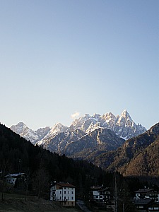
The Marmarole (seen above from Calalzo) are a mountain group belonging to the Dolomites. They are situated in the area of Centro Cadore, in the province of Belluno. They are a fairly isolated – and not so heavily frequented – range, which certainly adds to their charm, as these are in all respects beautiful mountains with nothing to envy to the most celebrated – and better known – peaks of the Dolomites’ heartland (such as nearby Pelmo and Ampezzo Dolomites, as well as the further Sella and Marmolada).
This range is fairly close to the Antelao, which is another famous Dolomite giant, and it is crossed by the paths belonging to the Alta Via no. 5 – so called ‘of Titian’ (“Alta Via del Tiziano”) – in honor of the great Renaissance painter, who was born in the nearby town of Pieve di Cadore and is said to have portrayed these majestic, jagged peaks as a backdrop to many of his paintings.
Characteristics
In many respects, from a geo-morphologic point of view, the Marmarole can be considered as the only true mountain chain belonging to the Dolomites in full. They can in fact be imagined, in perspective, as a mighty rock wall that, starting at the Forcella Grande – at the base of Cima Bel Prà, above San Vito di Cadore, runs uninterrupted for about 13 km with an W → E development, to end at Monte Ciareido, just above the Pian dei Buoi plateau (near Lozzo di Cadore).
The entire range can roughly be divided into three separate sections – Western, Central and Eastern.
The Marmarole Occidentali (Western ~) comprise the mountain peaks distributed as in an amphitheatre facing north, and developed around the Val di Mezzo Grande, between Forcella Grande and Forcella Vanedel. Within this sub-group are included many summits, and one should at least mention the Torre dei Sabbioni (2,531 m) and the Corno del Doge (2,615 m). At the head of the valley is the Voltolina Bivouac, belonging to the Fondazione Antonio Berti.
The Marmarole Centrali (Central ~) present a slight inclination towards the north, with a singular morphologic contrast between the two opposing sides: the southern slope precipitates onto the Val d’Oten (near Calalzo), while the northern slope is actually much softer in shape, and presents a series of deeply-cut side valleys. In service of this sub-group, on the northern side, are the Musatti Bivouac (Fondazione Antonio Berti) and the historic Bivouac Rifugio Tiziano – both important footholds for the ‘Alta Via no. 5’. On the southern slope are instead three proper mountain huts, Rifugio San Marco, Rifugio Galassi and Rifugio Chiggiato (see below).
The Marmarole Orientali (Eastern ~) begin by the Forcella Bajòn, and comprise the slender needles of the Ciastelìn and Ciarèido: these are more modest elevations in comparison to those of the other sub-groups, but fascinating nonetheless. The southern side is also serviced by two good mountain huts, Rifugio Bajòn and Rifugio Ciareido (see below, also).
Mountaineering in the Marmarole
The Marmarole are very beautiful, wild and rugged mountains, rendered even more attractive by their being so little frequented – especially when compared to other Dolomite giants; also, they were particularly dear to the great painter of the Dolomites, Titian (Tiziano Vecellio).
The Alpine exploration of these mountains was started around 1890 by Ludwig Darmstädter, and was continued in the aftermath of WW1 by Berto Fanton and his brothers. After WW2 the peaks of the Marmarole became a hub of activity for the so-called ‘Ragni di Pieve di Cadore’ (‘the spiders of Pieve di Cadore’), a local mountaineering group analogous to the more famous ‘Scoiattoli di Cortina’ (‘The Cortina squirrels’).
From Pieve di Cadore one can admire the Central and Eastern section of the mountain group; one can distinguish in particular the characteristic shape of the Croda Bianca, the so-called ‘Cresta degli Invalidi’ (the Invalid’s Ridge – it is not difficult to imagine the reason for that infamous name) and the Cimon del Froppa, the highest summit.
In Pieve di Cadore, the best view over the group can actually be enjoyed from the Parco del Roccolo, by the ‘Belvedere’, but in fact, even on the way up from Belluno – along the national road – these mountains appear majestically from the viaduct of Ponte Cadore, just before entering Pieve itself: from there, one can easily distinguish the towers of Ciastelìn and Ciarèido.
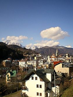
These same peaks – with the characteristic tower ‘Il Pupo’ – can be seen also from Lorenzago di Cadore, further east (in the image below, the rocky peaks of the Marmarole appear behind the houses of Pieve di Cadore).
Delimitation, Subdivision and Highest Elevations
The Marmarole are an extensive group, usually being subdivided into three sub-groups: the Bel Pra sub-group (a.k.a. Marmarole Occidentali – Western ~); the Marmarole Centrali (Central ~), and the Ciastelìn sub-group (a.k.a. Marmarole Orientali – Eastern ~).
The range is limited to the N and E by the Val d’Ansiei, which runs from Palùs San Marco through Auronzo di Cadore to Treponti (‘Three Bridges’), where the Ansiei joins the Piave.
The Piave valley then becomes the boundary to the S, in the section from Treponti to Calalzo; then the limit runs along the tributary Val d'Oten from Calalzo to Forcella Piccola and until Forcella Grande. Lastly, to the W, the group is contained by the Val di San Vito, from Forcella Grande to Palùs San Marco.
The main peaks (in decreasing order of height) are, in the Western section: Cima Bastioni Sud (2,926 m), Cima Bel Prà (2,917 m), Cima Scotèr (2,800 m), Corno Del Doge (2,615 m), Torre dei Sabbioni (2,531 m); in the Central section: Cimon del Froppa (2,932 m), Pala di Meduce (2,864 m), Le Selle, (2,851 m), Croda Bianca (2,841 m), Cima Vanedel (2,797 m), Campanile di San Marco (2,777 m), Croda Alta di Somprade (2,645 m) and, lastly, in the Eastern section: Monte Ciastelin (2,601 m) and Torre San Lorenzo (2,504 m).
Legends and Curiosities
The name ‘Marmarole’ derives – in all likelihood – from the Greek word ‘marmar’, which means ‘to shine’ or ‘to sparkle’, and is also at the root of the word ‘marble’ (‘marmo’ in Italian). In this case, however, this is not so much in reference to the rock, but rather to the abundant presence (certainly more so in ancient times than today) of snow and ice on the northern side of this mountain group.
In fact, once the Marmarole hosted as many as five glaciers – the ‘Froppa de Fora’ and ‘Froppa de Inze’, the ‘Meduce de Fora’ and ‘Meduce de Inze’ and the ‘Selle’ – today all but completely disappeared.
The tower known as ‘Campanile di San Marco’ certainly owes its name to the famous San Marco bell tower in Venice, which had just crumbled at the time when the peak was first conquered, in August 1902.
Lagole and the ‘Lago de la Femenes’
Legend has it that at Lagole (now an important archaeological site near Calalzo), on the shores of the ‘Lago de la Femenes’ (or Lago delle Tose; the ‘Lake of the Girls') used to stroll the girls and the brides of the ancient city of Sabassa: its waters – così verdi da sembrar scavate nella roccia (‘so green as to seem carved in the rock’) – kept their youth and beauty fresh. But the Anguanes (mythical female creatures – so-called in the dialect of Cadore – who used to live in caves along the Piave and the Molinà stream) were so jealous that one day they captured one of them, Bianca, who also happened to be the daughter of the chief of Sabassa; this event took place along what is still known today as Troi del sassìn (‘path of the assassin’).The high crags that overlook this location were instead given the name of ‘Croda Bianca’ (‘White Rock’).
Some suggest that the mythical creatures that entered the popular imagination as the malevolent Anguanes are none other than the transformation, during Christian times, of a divinity of the Paleoveneti, Trumus Icatei. In fact, this Pagan cult has been ascertained for the area of Lagole, as a votive slab dedicated to a Water Goddess was found here together with abundant figurative and epigraphic material, which was recovered during the course of the archaeological digs carried out in the second half of the 20th century.
The area of Lagole had already given a few bronze objects of a certain importance through occasional finds at the end of the 19th century, and then again in the first half of the 20th century; above all must be mentioned the situla with an inscription in ancient Venetian language found in 1914 in the area of the station in Calalzo. Subsequently, between 1947 and 1949, came to light numerous specimens of handles of Bronze simpulum with inscriptions and Roman coins in bronze, copper and silver. During the digs organized in 1949/50 some small bronze artifacts were also found, with figurative details of animals and warriors, together with more simpulum handles, embossed laminae, various other bronze artifacts and more coins. From 1950 onwards – thanks to the intervention of the Sopraintendenza delle Antichità di Padova – came to light the majority of the ex-voto of Lagole: various simpulum handles; fibulae of different shapes; fragments of laminae (also embossed); knives; coins; tintinnabula.
In order to find the first traces of the people who lived in Cadore before the Romans – The Paleoveneti – according to some Greek and Latin sources it is necessary to move along the shores of the Black Sea in an area corresponding to actual Northern Turkey, and meet the Paflagonians. After fighting (and losing) the War of Troy against the Greek, this people returned to their homeland, chose a new king (Antenore) and changed their name into ‘Veneti’; they then started to travel in search for new lands: they crossed the Aegean Sea and travelled up along the Adriatic, where eventually they found – at the end of their journey – the Venetian lagoons. Along the centuries, the Veneti – who had produced a rich and splendid civilization in the south of the region – extended their boundaries to the north, using the most important existing waterways, such as the Piave, Adige and Brenta. In the period of their maximum expansion, it is calculated that the region inhabited by the Veneti corresponded to more than the size of the actual ‘Tre Venezie’.
From the 5th century onwards, the Veneti started to experience the influx of the Celts, as several Celtic tribes were starting to settle down on the borders of their territory. Despite being culturally autonomous, the Veneti showed themselves to be an open people, available to exchanges with their neighbours, with whom they entertained friendly relations for a long time; gradual and peaceful was also the passage to the Roman civilization; the Roman right was given to some cities, while a few of the old settlements of the Paleoveneti became ‘municipia’, and some other ‘colonies’. Gradually, the Latin alphabet was adopted, and the Roman monetary system was also introduced.
The water of Lagole is particularly rich in sulphate, bicarbonate, calcium and magnesium. Its chemical composition justifies the fact that – in the popular tradition of old times – this water was considered to have therapeutic properties, which in fact has has been confirmed by subsequent mineralogical analysis later on. The water can be used for stomach and liver complains but also for inhalation and for inflammations of the respiratory system; it can be used in mud baths too, to help with several pathologies. In the popular tradition, it is generally believed that this water will also help with several skin complaints; it is said that a long time ago the people of Calalzo used the water to heal wounds in both men and animals, and that thanks to the water of Lagole recovery was steadfast.
The ‘Croderes’ and the Queen of Tanna
This is another beautiful legend from the Marmarole. As the story goes, the mountains anciently known as ‘Marmarolles’ were once inhabited by the Crodères – creatures unable to have feelings, as their heart was made of stone – and ruled by their queen, Tanna. In the ‘day of silence’, which came once in a year, in their kingdom everything stopped – not just the living creatures, but inanimate things too: snow did not detach itself from the rocks; ice and stone did not melt or slide down, and not a single leaf moved. This happened because this was the only day in which the Queen of Tanna recovered her feelings, and felt sorrow again for the loss of her son Salvanèl and his bride, Marcora. He had, in fact, to expiate the betrayal that that had led his mother, Tanna, to marry the Prince of Aquileia – a choice that forced her to flee the sparkling Marmarole and her people, the Crodères, and that would make her unhappy for the rest of her life. The absence of the Queen, however, meant that Nature could become benign towards men.
In the ‘day of silence’ Tanna goes back again to her Palace made of ice on the Cimon del Froppa, dressed in black and with a veil on her face, wearing also a crown adorned with blue precious stones; there, she sits among the golden coffins of her son Salvanèl and Marcora. On that day, men can go freely about the mountains without fearing its dangers, and they can work in the gold and silver mines peacefully, as in the days of Tanna’s betrayal. After that, though, Tanna goes back to be the Queen of the Crodères: proud of her beauty and cold as the rocks of her mountains, loveless towards mankind and animals alike. Nature returns therefore harsh and bitter too; landslides and avalanches render the rocky Marmarole an inhospitable land for all living creatures.
Tanna’s betrayal – and her abdication of the crown – has to be seen as a symbolic act of renounciation to Paganism, substituted by Christianity, which was introduced in the valleys of Cadore precisely by the Patriarchs of Aquileia (to which the region once belonged). It is said that the very name of Tanna – according to some scholars – is of Semitic origin, and it roughly means ‘to resound’, ‘to echo’ – perhaps a reference to the resounding quality of these rocks.
Trails and Mountain Huts
The Rifugio San Marco is situated in the municipality of San Vito di Cadore, at the ‘Col de chi da Os’, 1,823 m – a hillock at the limit of the tree line; it is situated almost right in the centre of a basin surrounded by the three massive Dolomite giants of the Antelao, the Marmarole and the Sorapiss.
From the hut one can in fact follow the routes that ascend to the summit of Antelao, as well as admiring the elegant rock walls of the Cima Bel Prà, at the eastern edge of the range. As a note of curiosity, this is one the few Alpine huts in the area to have retained the original structures in the interior, thus reminding of long-forgotten atmospheres of the Dolomites ‘d’antan’.
The Rifugio Galassi is situated just under the Forcella Piccola (2,018 m), at the margins of the trails that form part of the Alta Via n° 4 (Alpine Highway No 4, 'Grohmann’) and Alta Via n° 5 (No 5, ‘Tiziano’), in an area which is also at the confluence between the groups of the Antelao and the actual Marmarole.
The Rifugio Chiggiato (1,911 m) is situated instead on the southern side of the Western Marmarole, and it can be reached via two different accesses, either by flanking the base of the range from Lozzo di Cadore westbound, or from Calalzo di Cadore, along the road of the Val d’Oten at first, then entering the woods of the Valle Vedessana.
The excursion to Rifugio Chiggiato is a relatively simple and not too strenuous one, and the hut deserves a visit even if one should decide not to continue any further, for the beautiful location where the building is situated, right in the middle of an open meadow surrounded by powerful Dolomite crags.
The Rifugio Bajòn-Elio Boni is also situated at the foot of the Marmarole, at about 1,800 m in the territory of Domegge di Cadore. The hut was once a ‘malga’ (cow-pen), used when cattle were grazing in altitude during the summer. It was transformed into an Alpine hut only in the last few decades, and it can be reached by car from the town of Lozzo di Cadore with a steep road that after a long series of hairpin bends leads to Rifugio Marmarole first; from there, one can continue higher up to Rifugio Ciareido (see below), turn right and go towards Col Vidàl; turning left leads instead (after an additional hour) to Rifugio Bajòn, which can also be reached on foot from Domegge di Cadore.
As it is a very narrow road, the access from Lozzo di Cadore is traffic regulated during the summer on an alternated time one-way system: way up only in the morning, way down only in the afternoon (then open in both senses from the evening to the early morning).
From Rifugio Bajòn several excursions can be enjoyed: through the Forcella Bajòn one can reach the Fanton Bivouac; otherwise one can aim for the Forcella Marmarole, which presents a short ‘via ferrata’ – that however should be attempted by experienced mountaineers only – after which one passes Forcella Froppa and arrives at the Tiziano Bivouac. From the rifugio Bajòn one can also pass just under the Marmarole and connect to paths to Rifugio Chiggiato (see above), from which one can complete the roundtrip and descend to Calalzo.
The Rifugio Ciareido (1,969 m) was first erected by the Italian army as a building in service of WW1 activities – especially as an observation post, as it was not far from the frontline. It was then used in the following years as a shelter for hunters and as occasional sheep-pen; only after the 1970s it was finally restored and turned into the high-altitude facility that it is today, renowned for its beautiful views.
The location can be reached in several ways: the road from Lozzo di Cadore to Pian dei Buoi (see above) is the most straightforward option, but one can also come through the Val da Rin or even from Monte Agudo, which can be reached in turn via a chairlift from Auronzo di Cadore. Numerous paths also climb up here from Lozzo, for example along the Rio Rin, or through the localities of Quoilo, Pian dei Formai (the ‘cheese plain’ – a clear indication of the sort of activities that used to be carried out here) and Casera delle Armente. From Domegge di Cadore, too, one can branch off at Deppo and take the lane that leads up to rifugio Bajòn first, and then here.
From the hut, several excursions can be enjoyed in different directions; more demanding options for experienced mountaineers are also available, such as the ascent to the Torre Pian dei Buoi (2,358 m) through the ‘Via Ezio del Negro’, or the Rock Climbing Site at about 2,100 m of altitude. The location of this hut – being on a very sunny and open plateau, with undulated trails – is also preferred in wintertime for excursions in the snow or off-piste with the ski.
Return from Marmarole to Dolomites
Return from Marmarole to Italy-Tours-in-Nature

New! Comments
Have your say about what you just read! Leave me a comment in the box below.