- Italy Tours Home
- Italy Ethos
- Tours 2023
- Blog
- Contact Us
- Dolomites
- Top 10 Dolomites
- Veneto
- Dolomites Geology
- Dolomiti Bellunesi
- Cortina
- Cadore
- Belluno
- Cansiglio
- Carso
- Carnia
- Sauris
- Friuli
- Trentino
- Ethnographic Museums
- Monte Baldo
- South Tyrol
- Alta Pusteria
- Dobbiaco
- Emilia-Romagna
- Aosta Valley
- Cinque Terre
- Portofino
- Northern Apennines
- Southern Apennines
- Italian Botanical Gardens
- Padua Botanical Garden
- Orchids of Italy
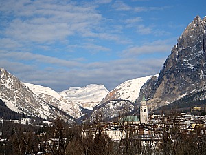
The Ampezzo Dolomites: Celebrated Peaks in Pristine Nature Just North of Cortina.
The Ampezzo Dolomites (Dolomiti di Ampezzo in Italian) are protected by a “Parco Naturale Regionale” (Regional Natural Park) created in 1990 and extended over 11,200 ha.
The park is run by the so-called “Regole di Ampezzo”, an ancient consort of families among private citizens whose origins date back to the Middle Ages.
The protected area neighbours two other reserves in South Tyrol (Dolomiti di Sesto/Sextnerdolomiten and Fanes-Sennes-Braies/Prags), whose borders run just to the north of the Ampezzo Dolomites Regional Park.
The protected area comprises mountain groups which are among the most mythical and celebrated in the Dolomites, both for the mountaineering epics they saw and for the events revolving around WW1.
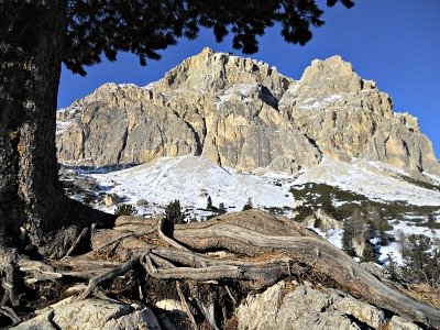
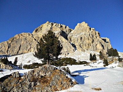
Names already give away a clue as to the uniqueness of these mountains: among the most famous summits are those of the Tofane (peaking at Tofana di Mezzo, 3,243 m), the Croda Rossa (the ‘Red Rock’, 3,145 m – so called because of the iron dioxides that give it a rich red-ochre tinge; see image above), and Monte Cristallo (3,221 m) – literally, the crystal mountain.
Among the most important valleys crossing the territory of the reserve, which covers the very upper reaches of the Boite valley, are those of its tributaries: the Felizon, Fanes, Travenanzes and Padeon streams.
Water is an important feature of the reserve, as it also forms some small lakes – the most notable of which, for their vegetation, are those of Foses, but also the Lago Nero (the black lake), and the lakes of Rufiedo, Fodara, Fanes and Remeda Rossa are worth mentioning.
Geologic Features
In Cortina there is an important Paleontological Museum dedicated to Rinaldo Zardini, a famous local paleontologist and fossil collector who contributed enormously to the naturalistic knowledge of the area.
His collection of fossils is displayed together with examples and explanations on the geology of the Dolomites. The museum is now hosted in a new building at Pontechiesa, just off the northern end of the pedestrian area.
As far as geology is concerned, even an untrained eye will not fail to detect the spectacular array of exceptional, multi-layered rock formations that tell a story which is hundreds of millions of years old.
Calcareous rocks and Dolomite (double calcium carbonate: the main rock responsible for the formation of the Dolomites – so much so that these mountains take their name from it) from the Triassic lie side by side with other more recent formations, such as grey limestone, the famous “Rosso Ammonitico” (a red stone), the Puez marl (a rock type taking its name from the mountains bearing the same name) and Flysch formations.
Spectacular are also the red clays and the multi-coloured rock layers of the Travenanzes Formation (previously called Raibl Formation; “Strati di Raibl” in Italian – you may still find this name in old books), which separate the Main Dolomite formations (“Dolomia Principale”) from the Heiligkreuz Formation (formerly Durrenstein Formation).
In the Ampezzo Dolomites Regional Park the morphology is characterized by plateaus of karst origin, surrounded by the Dolomites’ high cliffs and dominated by the typical needles, pinnacles and steep detritus-covered slopes (scree) – although there are also softer forms with terraces, ledges and small flat areas where tiny interglacial lakes sometimes have formed.
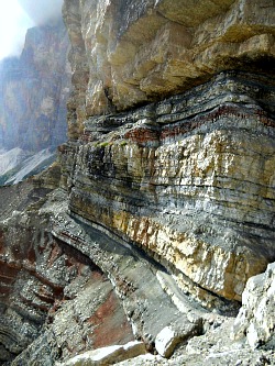
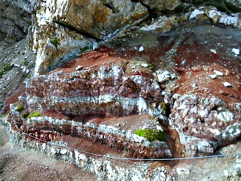
Slightly more to the west of Cortina there is a chance to visit a couple of locations which are quite interesting in order to acknowledge oneself with the geology of this part of the Dolomites: the Sentiero Geologico Astaldi (Astaldi Geologic Trail) is situated at the foot of the Tofana, and it can be accessed from the Rifugio Angelo Dibona (2,083 m), located off the National road (Great Dolomite Road) along the stretch to Passo Falzarego.
This is a very interesting itinerary, almost suspended on a narrow ledge among incredible multicoloured rocks; see above and below two pictures of the Sentiero Geologico Astaldi, with the iron rope clinging on to the rock wall (second image). The crimson-red coloration is due to the presence of the Raibl layers (Strati di Raibl); for more detailed information on this trail, refer to the Tofane page).
A word of warning: although, in my opinion, this trail is an absolute highlight within the context of the Dolomites – and a rope fixed to the rock wall makes the experience quite safe – let me make this clear once and for all: despite not being, strictly speaking, a via ferrata – and therefore technical equipment not being compulsory – still great care should be taken when walking along the Astaldi Geological Trail, in both directions; also, it is not advised to people with little hiking experience or who are afraid of heights.
Another worthwhile visit, for its geologic features, is that to the area of the Cinque Torri (2,361 m), on which an easy-to-read publication has been written; it can be found on sale for a small price at the Cooperativa di Cortina. Bearing in mind that it is only in Italian, if you can read this language it gives an in-depth – but easy to understand – overview on the main geologic features of this area.
The Flora of the Ampezzo Dolomites
As for the flora, the park has adopted as its symbol the Dolomite Houseleek (Sempervivum dolomiticum), an endemic species that grows in sunny locations in rocks and crevices at high altitudes, and blossoms profusely at the height of summer.
But the flora of the reserve comprises also some rare species that are found in the Red List of endangered species, such as Moheringia glaucovirens, which also finds its habitat on rock faces.
Of exceptional value are also the high-altitudes marshlands and the remnants of ancient peat bogs; especially valuable on that respect is the Foses basin, rich in botanical treasures.
Among the other notable habitats are the sheltered rock ledges, even though the most spectacular blossoms appear – as usual – in the high altitude prairies, meadows and pastures.
Particularly noteworthy is the Elinetum – a formation dominated by the soft tufts of a grass, Elyna myosuroides – while small depressions and nival valleys (where the snow lingers longer) are dominated by dwarf willows.
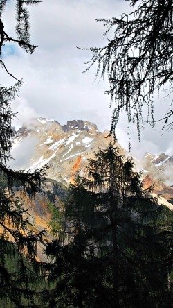
The most characteristic woodland formation – covering the sub-alpine vegetation zone between 1,700 and 2,100 metres – is the association between larch and Arolla pine (Pinus cembra), usually sparse and full of light, and interspersed with pasture lands. There are also, scattered here and there, very ancient and twisted, monumental specimens of Pinus cembra – such as the one pictured below, at the foot of Lagazuoi.
Many bushes are to be found in its understory – especially the two types of dwarf Alpine Rhododendrons (both commonly known as 'Alpenrose'), Rhododendron ferrugineum and R. hirsutum.
A peculiarity is represented by the fragments of old woodland (the so-called ‘vizze’) that are still regulated by the ‘Regole’ – century-old institutions that get their name precisely from the verb ‘regolare’ (which means ‘to rule, govern’), bearers of an ancient form of common use of the land .
A certain amount of wood produced by the ‘vizze’ is allocated yearly among the ‘regolieri’ (the members of the ‘Regole’) for their own private use.
Other valuable habitats are a type of woodland mainly composed of spruce growing on carbonate soil, a mixed woodland with Silver fir, and the purer conifer woods in the most continental section of the reserve (in terms of climate), between Ospitale and Cimabanche/Im Gemärk.
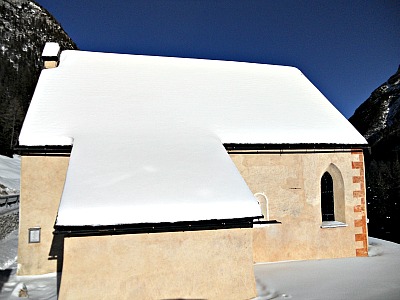
Incidentally, near the small hamlet of Ospitale, along the National Road, is also the main architectural gem of the reserve – namely, the tiny church of the Saints Biagio and Nicolò (see image below). It is in fact Ampezzo's most ancient religious building, with fragments of 12th-13th century frescoes.
Further along the National Road to Dobbiaco/Toblach, several trails ascend from Passo Cimabanche/Im Gemärk and lead – amongst other places – to Rifugio Vallandro/Dürrensteinhütte (2,040 m): a mountain hut on the edge of the beautiful highland pastures of Prato Piazza/Platzwiese, from which it is possible to descend by the shores of the picturesque Lago di Braies/Pragssee on the other side.
Otherwise – but you would need a bit more training for this – there is also the possibility to ascend from Prato Piazza/Platzwiese to the peak of Picco di Vallandro/Dürrenstein (2,839 m), which would reward you with a wide open view. An easier option from there is to climb up Monte Specie/Strudelkopf (2,307 m).
But even if you don’t want to venture any further, Prato Piazza/Platzwiese is in itself a beautiful location: a wide, undulated upland pasture with stunning views over the Dolomites to the south (see image below) and the Tauern chain (at the border with Austria) to the north. There are at least three mountain huts here, on which you can rely for accommodation and/or a hearty meal.
The two main ones are Rifugio Prato Piazza/Platzwiesehütte (1,991 m) and Rifugio Vallandro/Dürrensteinhütte (2,040 m), already mentioned above; a third facility is open summer only.
Itineraries Within the Ampezzo Dolomites
The centuries-long tradition of keeping high standards of woodland and pasture management – taken care of by the ‘Regole’ – has played a big part in shaping the landscape of the Dolomiti di Ampezzo.
Cattle farming still plays an important role within the park nowadays, but it is coupled with conservation needs. Within the reserve there are still some structures (known as ‘baite’ or ‘malghe’) that the ‘Regole’ traditionally use as dairies and cow-pens (among these are Malga Padeon, Malga Alpe Lerosa, Malga Foses).
The boundaries of the Ampezzo Dolomites Nature Reserve have been traced in such a way as to leave out the ski slopes and the most frequented Alpine huts; nevertheless, inside the perimeter of the park are contained a few structures that are instrumental when visiting the area.
Amongst these, noteworthy for their location are the Rifugio Biella/Seekofelhütte (2,327 m), on the karstic plateau between Sennes and Foses (Altopiano di Sennes) within the Fanes-Sennes-Braies Nature Park, and the Rifugio Giussani (2,580 m), in the heart of the Tofane group.
More easily accessible (even by jeep during the summer months) are the very popular hubs of Malga Ra Stua (1,668 m) and Rifugio Sennes (2,126 m).
The network of paths and trails is well-developed, and allows visitors to reach all the most interesting areas, but choices on how to manage the protected area are oriented towards avoiding excessive disturbance to the most fragile ecosystems.
Numerous itineraries are possible, from all of which wonderful views can be enjoyed. Malga Ra Stua – as anticipated before – is a particularly well-known spot within the reserve, and acts somehow like a sorting hub, as all the most notable itineraries can be taken from there (such as, for instance, those towards Foses and Lerosa; the picture below is taken instead from the beautiful trail that leads from Malga Ra Stua to Rifugio Fodara Vedla, at roughly 1,990 m of altitude).
For more information on the part of the territory of the Ampezzo Dolomites Nature Park bordering with the Fanes-Sennes-Braies Nature Park check also the relevant page (Fanes-Sennes-Braies, precisely), as some of the mountain huts described here (notably, Rifugio Fanes, Sennes, Fodara Vedla, Vallandro and Prato Piazza) are in fact located within that neighbouring reserve.
Other strategic locations include Fiames and Ponte Felizon, which are located along the National Road No. 51; here there are also small information points from which to get your first orientation around the Ampezzo Dolomites, as well as maps of the park. The Fanes waterfalls are a particularly striking feature within the reserve, and they can be easily accessed from here.
The area of the park is also crossed in all of its length by the old track of a disused railway line that once connected Cortina to Dobbiaco/Toblach, and that it was converted long ago into a cycle route (which then transforms into a cross-country ski route in winter-time, particularly favoured for its gentle gradient).
Other paths can be taken from the Passo Falzarego (2,105 m), along the Great Dolomite Road; from there, one can reach the Forcella Col dei Bos (a mountain pass) and the Tofane group (3,243 m).
The Biotopes at Passo Falzarego
The area around Passo Falzarego constitutes an area of great value for botanic interest and vegetation – so much so that it has been classified as 'biotope'. This fact is determined – in the first instance – by the characteristics of the soil, whose matrix can be ascribed to the Raibl Formation or to a marl-sandstone structure, which is easily subject to erosive processes and it is also affected by surface running water that contributes to the deposit of peat layers, in correspondence with hollows on the ground or by the modest terracing.
This area is very articulated from the point of view of vegetation; in particular, one can observe the following habitats: shrubs (particularly important are the remaining patches of Rhododendron); pastures and meadows, noteworthy for their landscape relevance but also for their floral and ecologic aspects, with extensive populations of Alchemilla – in the area of Falzarego Pass and by the lifts at Col Gallina – which are of particular interest. Peat bogs and humid slopes: by Passo Falzarego are known to be several humid biotopes, some of which have been discovered quite recently; from a botanic point of view, some stations of Juncus arcticus have also been individuated here not long ago.
Around the whole area situated by the ski-lifts at Passo Falzarego – and on the Cinque Torri-Nuvolau slopes – there are also some extensive sub-hygrphyle populations of Alchemilla; these habitats occupy wide expanses not only in the flatter sections but also along the slopes. Important too are the primitive habitats (rocks and rock layers; detritus): these detriti (scree and rock deposits) express the classic Dolomite succession, with a tendency to evolve – wherever the disaggregating phenomena that act on the rocks lessen – towards more primitive Firmetum and Seslerietum associations. Woodland formations: the forest component here is mostly ascribable to two fundamental types: Sub-alpine woodland with Norway spruce (Picea abies; a little more than 10%) and a mixed formation with larch and Arolla pine (Pinus cembra; almost 30%) – a species which is present also with some majestic, multi-centenary specimens (see picture below). These mature (climax) formations are particularly rich in primary, valuable ecologic information.
Particularly interesting in this area are also the Willow formations: the species identified here are quite numerous; some of them are included in the Red List too. Salix mielichhoferi, S. waldsteiniana, S. caesia, S. foetida, S. hastata, S. glaucosericea, S. nigricans and S. appendiculata are only some of the species that can be found here, without considering the dwarf ‘espalier’ willows of the Salicetum retuso-reticulatae association.
Important are also the herbaceous formations in which species belonging to different Alpine vegetal associations (also in habitats protected at European level) live side by side: found here are representatives from the Seslerietum and Caricion firmae; Nardetum; alkaline peat bogs ascribable to the Caricion davallianae, and also acid peat bogs related to the Caricion fuscae; plant consortiums with hygrophile ‘tall herbs’ and also more modest patches of bryophytes found by small springs (Cratoneurion). Within all these formations there are numerous rare species, amongst which are to be mentioned Juncus arcticus; the orchid Dactylorhiza cruenta; the willows Salix foetida, S. glaucosericea; Epilobium nutans; Carex dioica.
On the driest fields and meadows, once regularly scythed (the toponym Falzarego is not by chance, as it comes from the Italian falciare: to scythe), can also be found some other noteworthy or even rare species, such as Astragalus alpinus and Scented Black Vanilla Orchid, Nigritella rubra. In some areas, some sub-hygrophile associations could also become established, with various species belonging to genus Alchemilla, decidedly prevailing. At the ecologic level, these conditions are ascribable to those in which Green Alder formations (Alnus viridis) dominate.
In terms of fauna, the Golden Eagle (Aquila chrysaetos) is certainly the most noble presence here. This majestic bird of prey is the typical predator of high altitude meadows; amongst its preferred preys are marmots, which abound in these open pastures and meadows. The the Golden Eagle has strongly pointed claws that allow it not just to grasp, but also to push its prey, making its lose its balance and eventually fall (this is a hunting technique). Its nest is usually located in a cleft in the rocks, normally at lower altitudes in comparison to its hunting territory: this allows it to glide while holding its prey, thus harnessing the force of gravity.
The Cristallo Circular Route
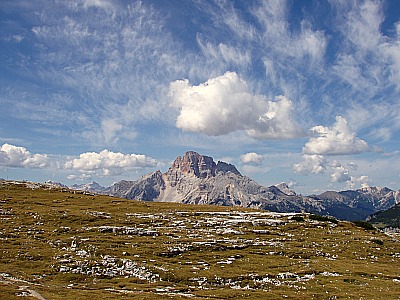
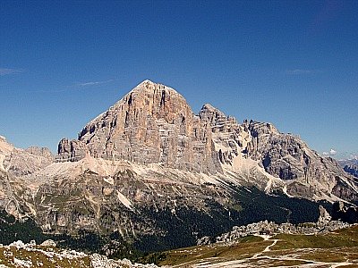
From Passo Tre Croci – on the opposite section of the Great Dolomite Road that branches off eastwards from Cortina – one can reach the Rudavoi area and the Cristallo (3,123 m, one of the most majestic mountains in the Ampezzo basin.
The beautiful round-trip around Monte Cristallo lies also, in part, within the territory of the park. Ideally, this itinerary is best taken if one exits Cortina northbound along the National Road No. 51, which is followed closely to the side by the ex-railway cycle path.
The first section is dominated by the towering peaks of the Pomagagnon (2,450 m) to the right, while the Tofane group is to the left; the road then touches in sequence a few of the locations cited above, entering the territory of the reserve at Fiames.
Further on, at Ponte Felizon, the country lane (or the paths) to Malga Ra Stua and the Fanes plateau branch off, leading also to the Fanes-Sennes-Braies Nature reserve; after a few sharp bends, the road then goes past a few buildings and the beautiful church of Ospitale (see above).
Going in this direction, the Cristallo is always to the right of the National Road, and the views become more impressive past Carbonìn/Schluderbach.
At Col S. Angelo, one will then go past the deviation for the Rifugio Auronzo and the Tre Cime/Drei Zinnen (toll road); soon after is the Lake of Misurina, belonging to the municipality of Auronzo.
The return to Cortina uses the last section of the Great Dolomite Road. Just after Passo Tre Croci (1,805 m), always to the right, there is a chairlift station that will take you straight to the 3,000 m of Rifugio Lorenzi, situated in an amazing position below the summit of Cristallo, and offering breathtaking views over the whole Dolomites’ heartland.
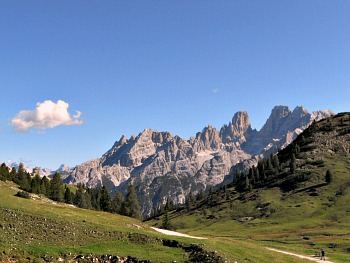
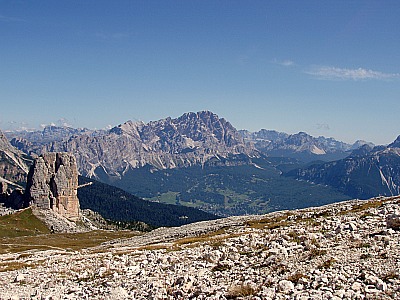
Just outside the park boundaries, Malga Larieto also operates as a useful facility (mountain hut and restaurant), run by the ‘Regole’ conjointly with the park authority (in the picture below, the Cristallo as it is seen from the Cinque Torri area).
The Lagazuoi
The Lagazuoi (2,835 m; Lagazuoi-Berg in German) is a mountain belonging to the Fanis Group; from a strictly geographical standpoint, it is part of the Eastern Dolomites of the Val Badia/Gadertal, even though it is more often associated with the Ampezzo Dolomites because of its proximity to Cortina, and also for its being inextricably linked with it from an historical point of view (especially the war events). Despite the very close proximity of the border with South Tyrol, from an administrative point of view the mountain belongs entirely to the Veneto, and it is divided between the territories of Cortina d'Ampezzo to the east and Livinallongo del Col di Lana to the west (below, an image of the Lagazuoi taken from the other side of the Falzarego valley).
The Lagazuoi is formed in reality of two clearly distinct sub-groups, respectively called Piccolo Lagazuoi (Kleinen Lagazuoi, 2,778 m) and Grande Lagazuoi (Großen Lagazuoi, 2,835 m), which stands behind it. The massif is delimited to the south by the Passo Falzarego (2,105 m), to the west by the Passo Valparola (2,192 m), to the north by the Alpe di Fanis and the Val Travenanzes and finally, to the east, by the complex of Cima Falzarego-Col dei Bos and the Tofane massif, which separates the range from the underlying Ampezzo Valley.
In fact, as a note of peculiarity, the Lagazuoi is the only mountain considered part of the Ampezzo Dolomites not to be visible from the conca (basin) itself, being concealed by the imposing bulk of the Tofana di Rozes (to be more precise, however, the Lagazuoi can be seen from the basin’s southernmost fringes – namely from the hamlets of Zuèl and Acquabona, also belonging to Cortina; below, an image of the Lagazuoi taken by the lower cable car station; notice the statuary presence of isolated specimens of Arolla pine – Pinus cembra).
History
During the course of WW1, between 1915 and 1917, the Lagazuoi was the theatre of harsh fights between the Italian and Austro-Hungarian troops, both of which dug a complex network of tunnel and galleries into the rock of the Piccolo Lagazuoi, and attempted at the respective positions through the explosion of mines.
In October 1915 the Italian Alpine regiment occupied some positions on the southern flank of the Piccolo Lagazuoi, amongst which was a narrow ledge then become famously known as Cengia Martini, which crosses the rock wall from west to east and was strategically important, while the Austro-Hungarian positions were located at the summit of the mountain itself.
In order to chase the adversaries from their fortified positions dug into the rock, the Austrians exploded three mines, the most potent of which in 1917 blew apart a rock wall almost 200 metres high; in spite of that, the Italian positions on the Martini ledge were not abandoned. In turn, the Italians dug a new gallery covering 200 metres of gradient inside the belly of the mountain, up to the ‘anticima’ of the Piccolo Lagazuoi; the crater generated by this huge explosion is still recognizable. After the defeat at Caporetto (later in 1917), the Italians withdrew from their positions, and all military operations in the area drew to a close, after consuming months spent in the high snow.
Excursions
The massif is endowed with an important cable car that connects the Passo Falzarego (2,105 m) at the base with the Rifugio Lagazuoi (2,752 m), on the Piccolo Lagazuoi. From there, numerous paths and mule-tracks depart in various directions; most of them are carefully signposted by the CAI (Italian Alpine Club): many take westward towards the Val Badia/Gadertal, northwards to the Val Travenanzes and the Val di Fanes and eastwards towards the Col dei Bos and the Tofane group (Tofana di Ròzes).
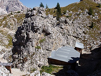
Recently restored, the galleries and the Italian and Austrian trenches of WW1 are now open to the public and can be visited freely as part of the Open-air War Museum (Museo all’Aperto della Grande Guerra), which offers a notable attraction of undoubtededly high historical and naturalistic value (below, see an image of the Open-air War Museum).
Other Mountain Groups in the Ampezzo Dolomites
The Nuvolau
The Nuvolau is another mountain group belonging to the Ampezzo Dolomites. It is situated in the municipalities of Cortina d'Ampezzo and, partly, of San Vito di Cadore, between the Passo Falzarego (2,105 m) to the NW and the Passo Giau (2.236 m) to the SE, straddling the Val CordevoleAlto Agordino and the Val Boite.
It culminates on Monte Averau (a.k.a. Nuvolau Alto), at 2,647 m, and it is among the less extended groups of the Dolomites; nevertheless, it is dominated by bald rock formations such as peaks and needles: often the slender Cinque Torri (a.k.a. Cinque Torri di Averau) are considered to be part of it.
The highest summits are Monte Averau, 2,647 m; Monte Nuvolau, 2,575 m; Gusela del Nuvolau, 2,595 m; Coston d'Averau, 2,518 m, Sass de Stria, 2,477 m, and the Cinque Torri, 2,361 m.
Among the most important Alpine huts of the area are: Rifugio Nuvolau, 2,575 m (near the summit of Monte Nuvolau); Rifugio Averau, 2,413 m (by the Forcella Nuvolau); Rifugio Cinque Torri, 2,137 m (right under the Cinque Torri) and Rifugio Scoiattoli, 2,255 m, on the Monte de Potòr.
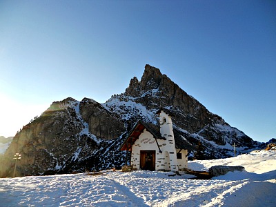
At the foot of the ‘Gusela’ (needle) is still visible the boundary cross between the “Serenissima Repubblica di Venezia” (Republic of Venice) and the Austrian-Hungarian Empire, today marking the boundary between the two municipalities. From the summit, one can follow on for a stretch along the main ridge; then the boundary line descends towards the Cinque Torri, until meeting the scenic second cross, which bears both the Lion of St. Mark’s and the Coat of Arms of the Hapsburgs. Upon reaching the ‘Becco della Muraglia’ – from which two additional headstones were removed in the 1970s – the line bends in a right-angle, then follows the famous ‘Muraglia di Giau’ until it meets the opposite rock cliff of the ‘Lastoni di Formin’ (below, an image of the charming isolated chapel by the Passo Falzarego).
The Conturines
The Cima Cunturines (or more simlpy Conturines) is the highest peak of the Conturines Group, in the Eastern Dolomites; it is 3,064 m high. It is located in South Tyrol, about 3 km to the east of the village of San Cassiano in Badia/St. Kassian, of which it dominates the skyline, and not distant from the Passo di Valparola (2,192 m), which marks the boundary with Veneto (therefore it is included here among the Ampezzo Dolomites).
The Alpine huts Rifugio Capanna Alpina (1,720 m), in the Alta Valle di San Cassiano, and Rifugio Valparola (by the pass, at 2,168 m) are optimal starting points for excursions and treks on the mountain, even on higher ground.
In September 1987 – during an excursion – were incidentally discovered here the remains of an old species of bear, never known before. It was later identified as Ursus ladinicus – that is, ‘Ladin bear’, so named in honour of the area where it was found (the historic ‘Ladinia’). The remains were found in a cave just under Cima Cunturines, at about 2,800 m of altitude, and are now kept in a specially built museum in San Cassiano in Badia/St. Kassian.
Return from Ampezzo Dolomites to Cortina
Return from Ampezzo Dolomites to Italy-Tours-in-Nature
Copyright © 2012 Italy-Tours-in-Nature

New! Comments
Have your say about what you just read! Leave me a comment in the box below.