- Italy Tours Home
- Italy Ethos
- Tours 2023
- Blog
- Contact Us
- Dolomites
- Top 10 Dolomites
- Veneto
- Dolomites Geology
- Dolomiti Bellunesi
- Cortina
- Cadore
- Belluno
- Cansiglio
- Carso
- Carnia
- Sauris
- Friuli
- Trentino
- Ethnographic Museums
- Monte Baldo
- South Tyrol
- Alta Pusteria
- Dobbiaco
- Emilia-Romagna
- Aosta Valley
- Cinque Terre
- Portofino
- Northern Apennines
- Southern Apennines
- Italian Botanical Gardens
- Padua Botanical Garden
- Orchids of Italy
The Oltrepiave Area: Where Nature and
the Art of Cadore Meet.
The Oltrepiave is one of the historical “centene” of Cadore, so-called because of its eccentric position in reference to the Piave, the main river that crosses the region.
As a matter of fact, ‘Oltrepiave’ literally means “beyond the Piave”, as these are the only villages to be found on its orographical left bank in this section of the valley.
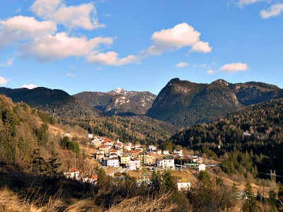
The area is formed by two quite distinct municipalities, of different importance and standing: Lorenzago di Cadore and Vigo di Cadore (above, an image of Pelòs, part of the municipality of Vigo; from the picture is evident the geographic set-up).
Lorenzago di Cadore
Lorenzago is spread along the main National road that leads to Passo Màuria and beyond into Càrnia, and most of it was rebuilt in the latter part of the 19th century (between 1855-65) by the architect Giuseppe Segusini, following a strict ‘Rifabbrico’ plan (for an explanation of the term, see Auronzo). This means that it is actually one of the few places where the outcomes of the ‘Rifabbrico’ movement can be best appreciated – and so is Vigo, albeit for different reasons (see below).
But sticking to Lorenzago first, even a passer-by cannot fail to notice the unusual grid-like pattern of the two parts that form the village, Villagrande (which is the ‘centre’ of town) and Villapiccola.
In both places, if you take the trouble to enter the grid of regular, straight streets (and not many people do), you will be greeted by a geometrical, impeccable repetition of streets crossing neatly at 90° – certainly a most unusual sight for an Alpine village, and not something you would expect to find here. For its grid of perpendicular streets, you could compare this to a small-scale Alpine city (like New York – or Barcelona, or Turin), even though, certainly, with no skyscrapers!
But it is a fascinating sight nonetheless: each street block is occupied by a typically three- or four-storey house, all strictly built in stone, most of them now painted in vivid colours. This was the main purpose of the ‘Rifabbrico’, after all: safely rebuild in stone – and in an orderly fashion – what were before villages mostly composed of wooden houses, all packed together and divided only by tiny alleyways (a set up which made these communities extremely prone to damaging fires).
Lorenzago is also surrounded – pretty much on all sides – by dense coniferous woodland, which makes walking in this area a particularly peaceful and solitary affair, given also that the village stands alone on the long slope that leads up to Passo Màuria, from which you can descend – should you wish to – into the Tagliamento valley to the village of Forni di Sopra, and further into the Dolomiti Friulane.
The surrounding Dolomites are the peaks of the very little-frequented groups of Crìdola (2,580 m), Monfalconi (2,548 m) and Tudaio (2,417 m).
History of Lorenzago
The name Lorenzago — from the Latin Laurentiacum — would probably derive from the name of the land tenure of a Roman homesteader who took up residence here, when the whole of Cadore became part of the Roman Empire. Lorenzago benefits of a privileged geographical position: it is located on a green, sunny plateau surrounded by soft slopes and covered by fields and woods, near the Piave river banks, and overlooking the lake of Centro Cadore. From the village, it is possible to reach the mountains of Monte Cridola (2,581 m), the ridge of Miaron and its four peaks (all of them at around 2,220-2,300 m a.s.l.), the Montanel mountain (m 2,441), the Tudaio-Brentoni group (max. elevation 2,548 m), while the more distant Antelao (3,263 m) — and many other peaks, such as the massif of the Marmarole (2,932 m) — also form a wonderful amphitheater for this spectacular valley.
The village is a long-esteemed holiday place. Lorenzago is divided into different parts: a dense and more compact one, composed of the two historic ‘urban’ hamlets of Villagrande and Villapiccola; another part is more modern (with the localities of Monteona, Dera, Piate, Rivadò). The two historic hamlets are connected by a stretch of the SS52 National Road, ‘Strada Statale Carnica’, which crosses the village and connects the area of Cadore with the Friuli region through the Mauria pass (Passo della Mauria, 1,298 m): a centuries-old transit place, which was probably also the entry point for the Celts. From there, the Piave valley is visible on one side, while the valley of the Tagliamento in Friuli can be glimpsed on the other; along the itinerary that leads to the Mauria pass there are wonderful views over the Dolomites: the mountains of the Marmarole and the small glacier of the Antelao lie to the north and west, on the other side of the Piave valley; the Cridola chain is much closer, and visible to the south-east.
The history of the village is tied to the history of the entire Cadore region. Lorenzago was populated since the Stone Age, as proved by the stone hammer found near the Mauria pass, probably used by the priests for sacrifices. Through this pass, as well as the Celts, also the Illyrians would have poured into Cadore. Later, maybe from 115 BC, Lorenzago and the Cadore region passed under the dominion of Rome. Between the 2nd and 3rd C BC Lorenzago was probably one of the first settlements in Cadore to be evangelized. Tradition has it that Saint Hermagoras (to which the parish church is dedicated today) passed through the Mauria pass too, as testified by the name “Prà del Santo” (the ‘Field of the Saint’), because he was sent to Aquileia by Saint Peter to preach Christianity (he is the patron saint of Udine too).
During its history, Lorenzago was dominated by the Herules (an East Germanic tribe who lived north of the Black Sea, in the third century AD), the Ostrogoths, the Francs, the Byzantines, the Langobards, the Patriarchy of Aquileia and the Republic of Venice. During the first years of the 16th C, Lorenzago — as other villages of Cadore — was a battle scene between the army of the Cambrai League and the Venetian Army. From that time to the 18th C, the village was no more tormented by foreign armies, but it was damaged by many fires (in 1616, 1716 and 1792).
In 1848 the village lived biting battles between the population of Cadore and the Austrian invader. On July 30th, 1855, a terrible blaze destroyed 57 wooden houses in Villagrande, and 300 people remained without their home; the village was then rebuilt following the new town plan designed by architect Giuseppe Segusini, based on a grid model (many European cities — such as Turin and Barcelona — were being expanded at the time after that model). The reconstruction (‘Rifabbrico’) was made following a town plan known as “Quadrato Romano” (Roman Square), innovative and modern for that period, and still today an architectural pride of the village. At the end of the works, the ‘Rifabbrico’ appeared as an organic and ample reconstruction intervention that redrew the urban image of Lorenzago (I must add, however, that even though the urban grid of Lorenzago makes it a unique village within the Alps, the level of maintenance of the built-up environment is not up to standards, which gives the locality a vaguely run-down atmosphere — a great pity).
In the centre of town there are also a lot of stately homes — surprisingly many, given the small dimension of the village — built up between the 16th C and the 19th C. The beauty of these patrician houses has owed Lorenzago the title of “Venice in the mountains”; amongst these houses stand out the ex-Mainardi mansion; the 16th C Tremonti-De Tone House; the De Lorenzo-Nodare House; the Tremonti-Felize House; the Tremonti-De Andol House; the Cadorin House; the Fabbro House (now Town Hall); the De Donà House and the Canonica House.
The Way of the Popes (Via dei Papi)
The Way of the Popes (Via dei Papi) is a spiritual path (long-distance trail) that goes through some of the most suggestive places within the Belluno province, following the biographical landmarks of four Popes. Starting from the high-level ground of the Alpine and Dolomite landscapes, with meadows and pastures, the path passes through rural areas and near rivers, up to the pre-Alpine area and the high plains (‘Alta pianura’) north of Treviso. There are two starting points: Canale d’Agordo (the place where Pope John Paul I was born), and Lorenzago di Cadore — the place where both Pope John Paul II and Benedict XVI spent their holidays.
From Canale d’Agordo — an important religious and economic center in the Biois valley — the trail follows the course of the Cordevole stream, and it goes through Agordo and Valle Imperina, a mining site famous during the time of the Republic of Venice. From the Charterhouse of Vedana, built in 1456 along the historic Via degli Ospizi, the trail then climbs down towards Belluno, where in the locality of Mussoi — now in the outskirts of the city — is the birthplace of Pope Gregory XVI (he was born here between the end of the 18th C and the beginning of the 19th C).
The other starting point of the trail is Lorenzago, and it runs along the Piave river; it then passes through Pieve di Cadore, the town where Tiziano Vecellio was born, and Longarone, where the graveyard of the Vajont tragedy victims can be seen. The trail then reaches Belluno, the provincial capital, enhanced by the Cathedral and its wonderful Baroque spire, realized for the Duomo bell tower after the design of Filippo Juvarra. From here, the trail continues along the right bank of the Piave, inside the territory of the Dolomiti Bellunesi National Park, and it reaches the historic town of Feltre, with the ancient Sanctuary of the Saints Vittore and Corona.
From Feltre, the place where Pope Luciani made his seminal studies, the path goes uphill and crosses the Piave, where it meets the road on the left bank of the river that leads to Lentiai and Mel (Val Belluna), with the majestic Zumelle castle — the only Medieval castle to have survived intact in the province of Belluno. From there, rising through the Praderadego pass (925 m) — an historic communication between the Belluno and Treviso provinces — it is possible to reach Vittorio Veneto, terminus of the “Way of the Popes”. This trail is connected to the network of the European spiritual trails, which from the North of Europe lead to Rome.
In Lorenzago, the trail starts from the Villa Mirabello, where Pope John Paul II stayed 6 times during his summer holidays. The itinerary slots in the thick beech woodlands and fir forests that hide clearings and meadows hosting different plant species, covered in flowers during the summer. By going through the trail it is possible to admire on the background the mountains of Montanel, Miaron — and the imposing mountain group of the Cridola. It is also possible to chance upon the wild fauna that populates this mountainous area, in addition to enjoying the song of many different bird species — reverberating in the silence.
The Romotoi Gorge
The territories of Lorenzago and Vigo are divided by the valleys of the Piova stream and of the small Rio Romotoi, which merge together and are, together, a tributary of the Piave. By walking the atmospheric trail inside the Parco dei Sogni in Lorenzago, or by rising along the ruins of the Mulini (mills) along the Piova, the excursionist, who is in search for a small adventure, will have the possibility to enter one of the most characteristic natural canyons in the area. An equipped trail leads one to rise along the rugged course of the Rio Romotoi, accompanied by picturesque landscape views and unique emotions. Once out of the small canyon, the itinerary continues into woodland and relatively wild environments such as the Val Ciarnera, along tracks which are not always so visible, up until the Forcella (pass) at Stabie, and from there to the Passo della Mauria. As an alternative, it is possible to close the trail by rising north towards Costa, to then descend to the Piova stream along the road to Dumelle. The uniqueness of the narrow gorge, set amongst precipitous rocks; the continuous tumbling of the limpid waters, the ‘facilitated’ difficulties in the repeated crossings of the stream, the almost total isolation of this area and its uncontaminated nature, make this long itinerary one of the most interesting in the area. From there one can continue to into Vigo (or do it in reverse order).
Vigo di Cadore, the “Little Athens of Cadore”
The Churches of San Martino and Sant’Orsola
If one half of the Oltrepiave (Lorenzago) is rustic and down-to-earth, the other half – namely, Vigo di Cadore – on the other hand, has a completely different feel about it: almost aristocratic, one would be tempted to say; in fact, because of its cultural leanings, Vigo has long been known as the “Little Athens of Cadore”, and for good reasons.
To begin with, it hosts not one but three important religious buildings: the least impressive of which (although still interesting) is the main church of San Martino (St. Martin), erected in the second half of the 16th century in a transition style between gothic and Renaissance.
Inside, there are paitings by Cesare Vecellio and a Crucifixion by the famous 19th century local sculptor Valentino Pancera, known as the Besarèl.
Beside San Martino is the small chapel of the Madonna della Difesa, which was erected in 1512-14 by an architect from Friuli, Nicolò Ruopel, following a vow at the time of the plague (same as for similarly named churches in the region – like in San Vito, for example).
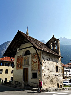
But the most captivating building in Vigo is certainly the small church of Sant’Orsola (St. Ursula): although a beautifully looking Gothic architecture, you wouldn’t think much of it from the exterior, standing as it does at the only junction of the village that has some degree of passing traffic – but once you enter it, it’s a different story altogether (below, a picture of the beautiful church of Sant'Orsola).
Erected in 1344-46 by Ainardo da Vico as a funerary chapel, even the exterior is all covered by 14th century frescoes (amongst them, a gigantic Saint Cristopher and a Madonna and Child), but it’s the interior walls of this tiny chapel that will literally blow you away, completely covered as they are with the most remarkable cycle of Medieval frescoes in Cadore.
Despite being partly quite gruesome, this cycle depicts in fascinating detail and with vivid colours the history of Saint Ursula, who was martyred in Germany in the 4th century AD – the whole story framed under a vaulted, starred ultramarine blue ceiling.
This sight is in itself worth a trip to Vigo, but be aware that the church operates a restricted and mostly seasonal opening time (summer only), so if you plan to make a stop here (and if you come to Vigo, you should), it’s better to check before making the journey. On the main altar, is also a Fluegelatar (wooden altar) by the renowned German artist Michael Parth.
As anticipated before, this village bears an interest for the ‘Rifabbrico’ as well: even though the rebuilding wasn’t as radical here as in Lorenzago, even in Vigo – especially in the neighbouring hamlet of Làggio – you will find traces of the typical grid of planned streets and uniform housing that denotes the ‘Rifabbrico’ style (1856-62, architect Palatini).
The main characteristic here is that in some cases the houses and the barns were separated, and you will be able to spot the difference between the two only if you look carefully at the building materials: rigorously stone for the residences and wood for the barns: even within the ‘Rifabbrico’ movement, this is something quite unique to Vigo and Làggio.
The Historic Library (“Biblioteca Storica Cadorina”)
To finish with the cultural aspect of Vigo, there is yet another institution that deserves a mention here: right as you enter the village, you will be greeted by a sign on a building that reads “Biblioteca Storica Cadorina”.
And this – the “Historical Library of Cadore”, which is also an archive – is a real treasure trove for the researcher, as it contains a precious collection of manuscripts and documents that mark all the most important stages in the cultural and historical development of the region. One could say that the relevance of this institution is second only to the Magnifica Comunità Cadorina headquarters in Pieve di Cadore.
Sometimes, exhibitions with an historical theme are organized here – and those are precious occasions in which to see on display some of the old books and parchments carefully guarded here, normally not accessible to the general public.
Làggio di Cadore and the Ancient Settlement of Salagona
Speaking of Làggio, there is more to mention here; specifically, there are two other notable religious buildings – and in my view, one of these is really the most captivating of all, not just for what you see, but also for what you don’t see.
The church in question is called Santa Margherita di Salagona, and again, from the exterior, it simply looks like a typically Alpine gothic chapel that doesn’t give much of itself away. But its location – isolated in an open field just outside Làggio – is the first indication of the importance of its history, as in ancient times there was a town around here.
The town of Salagona was later destroyed, and only the church was left standing; many centuries later, the area came to be built again with the nondescript homes you see all around, making you assume that this is just a non-descript part of the village – but it isn’t.
In fact, this is quite simply the most ancient church of Cadore, and on a first impression the interior may look empty, but once inside, and accustomed to the dark, you will see traces of frescoes that are even older than the ones in Sant’Orsola – in fact, the oldest in Cadore, as they date back to Carolingian times (around the 10th century AD).
Very pale and damaged, they nonetheless exert the fascination of a distant era, now infused in mystery – the dark and mythical allure of the deepest Middle Ages. This monument is therefore unique in the province of Belluno, so take the time to savour its atmosphere – bearing in mind, once again, that opening times are even more restricted here than in Saint Ursula, and so you would better check before you plan a visit.
In Laggio there is another religious building: the gothic parish church of Sant’Antonio, erected in 1454 by Nicolò Ruopel – but it is less interesting, compared to the other ones.
The Nature of the Oltrepiave
As you would expect, around Vigo di Cadore and in the Oltrepiave area at large there are also numerous opportunities for enjoying nature. An easy trail will take you from Làggio to San Daniele (1,197 m), an isolated chapel on a rocky outcrop (this itinerary is described in more detail below).
While scattered all around you will see remains of a WW1 military outpost, the path that leads to the chapel has been organized with labels as a simple botanical trail. In fact, should you wish to, you can continue further on past San Daniele, on the more demanding paths that climb up the slopes of Monte Tudaio, which at 2,417 m towers above the whole Oltrepiave area.
A single-track road, closed in winter, leads from Làggio to Sella Ciampigotto (1,790 m), and then on to Casera Razzo (1,760 m) – an open, undulated plateau that was traditionally used for animal grazing during the summer season, and that has been converted today as a walker (and plantsman’s) paradise.
With traditional cattle farming activities now dwindling, the location has become, in fact, an ideal destination for walking, immersed as it is in a section of the Dolomites that knows no overcrowding even in the busiest of months. From there, it is also possible to cross the border into Càrnia and the Dolomiti Friulane, eventually reaching the interesting village of Sàuris, renowned for its wooden vernacular architecture, and worth a visit in its own right.
Another road (now closed to the traffic) leads instead to Forcella Lavardet (1,542 m), doubling an ancient route that used to connect Comelico with the Val Pesarina through a solitary, abundantly wooded valley (the Val Frisòn), where it is still a pleasure to walk (and ski) today.
The “Via dei Pascoli” (Pastures’ Way)
This itinerary starts by the Sella Ciampigotto (1,790 m) and rises southbound towards the locality of Campoduro, along a trail which skirts the WW1 trenches – an area that witnessed the skirmish that took place between the Austrian and the Italian troops in November 1917. From Cima Campoduro one takes the ancient ‘dizzon’ (path) that runs under the ‘Col de la Cros’ and passes above the ‘Pian delle Vacie’, continuing until the area of ‘La Sella’. From there, one can reach the locality of ‘La Porta’ along the ridge – where the summit of Col Rosolo has been cut – and then descend to the locality of ‘La Zena’, by a fork between Col Rosolo and Monte Verna; these places too were the theatre of harsh clashes in November 1917. From ‘La Zena’ one can also descend to Casera Doana (aka ‘Casera delle Armente’); it is then possible to close the roundtrip and return to Sella Ciampigotto by continuing through to Doana, then down to the valley floor along the country track that takes one to the foot of Bosconero and along the ‘Roda de Doana’. Once crossed the bridge, one can then rise again along the ‘Valdescosa’, and pass in front of the rock known as ‘Crepo del Landro’.
The Historic Nature Trail Laggio - Col Ciampòn - San Daniele
This itinerary allows to visit the short Botanical Trail dedicated to Gabriele Larese; it also crosses the area of the WW1 Open Air Museum at Col Ciampon – a military outpost that had been created progressively between 1890 and 1917, just below the little church of San Daniele (1,197 m). From the centre of Laggio, one can proceed on foot along the former military track, crossing first the hamlet of Pociase: a nucleus of homes erected following the “General Rifabbrico” (rebuilding) from the end of the 1800s, wanted by the municipality in order to substitute the old wooden houses with new ones in stone, more comfortable and safe. The road then crosses the localities of Val, Ciareida and Tabià della Costa, where the military road takes a wide bend. Here we can admire a barn more than 250 years old, built with wooden logs in the traditional style of Cadore. From here to the locality ‘In Rota’, the road keeps a steady incline; then, once reached the ex-barn once belonging to the Zanetto family (today a private home), the track becomes flat, entering the site of the two “Tabià Bonate”, where it is possible to start admiring the plants and the flowers of the Botanical Trail (at the moment, all the labels have been temporarily removed because of works in the area, but the path remains available).
The track then takes another large bend into the Val Zenaria, where, in the lower part of this small side valley, one can notice the embankments of the military settlements that, during the Great War, hosted the stronghold of Col Ciampon; from there – with a gradual, light rise – (about 500 metres long), one continues along a stretch of road dug in the living rock, characterized by containment walls and flanked by a “Via Crucis”. Past the small chapel of S. Teresa one reaches a flat area at the top of the rise: this is the small plateau of Col Ciampon, where are visible a series of military outposts (‘Blockhouses’) that granted protection to the site. Here are some observation points, a few deposits and two shelters, plus some accessory defenses as well. A series of boards explains the historic and military value of this location. Recent works carried out to enhance the site have brought to light the remains of a shelter used by hunters and shepherds, dating back to the age of the Paleoveneti (about 5000 years ago). In the middle of the small plateau, a statue of the Peace Madonna dominates; it was placed here in 1991.
On the right side of the path, the trail continues climbing up towards the atmospheric chapel of San Daniele (1,197 m). Along the track – punctuated by boards that give historic information on the area – one also passes a small shrine dug into the living rock, where small crosses are placed by passing pilgrims. Legend has it that San Daniele and San Gottardo went up to the church through a small gap in the rock, and some signs still visible in the surrounding walls would be the imprints of their hands. About 10 meters higher, an inscription carved in the stone remembers a local woman who died here in 1841 during a pilgrimage – a poignant reminder of the mountain and its dangers; after about 5 minutes, one reaches the tiny church of San Daniele (this section of trail is described in more detail below).
From this location, the view opens wide over the whole Oltrepiave area, with the historic location of Tre Ponti and the – now mostly industrial – settlement of Cima Gogna in the valley below; the sight reaches all the way towards the distant Danta plateau, while at the back the imposing outline of Monte Tudaio (2,417 m) dominates, divided by the horrid cut of the stony Val Ciariè. From there, one can continue all the way to the summit of Col de Poèca (1,406 m), where is still visible the concrete platform of an intermediate station of the ex-zip-line leading to the fort on Monte Tudaio, from which one can continue to the Forcella di Valfisterna and descend towards Laggio via a different route. The majestic Antelao (3,263 m) is in sight in the background, while other Dolomite peaks encircle the surrounding landscape towards the W/NW.
The Open Air WW1 Museum at Col Ciampòn
This WW1 Open Air Museum, with simulations and an adequate number of boards that provide explanations on the site, relates to the first period of the fortifications that can be seen here (1866-1894), as well as to the WW1 years (1915-17), which have had quite a strong influence on the population of the Oltrepiave area. This project was made possible thanks to EU funds, but it could not have been realized were it not for the help of the numerous volunteers who have contributed, with their work, to the decor and maintenance of the site.
There is therefore an open invitation to visit this place in order to approach a not-very-well known chapter of the local history, and aknowledge oneself with events that had huge implications not only locally – with the added awareness that the sacrifices carried out by the many men (and women) who operated here in times of both war and peace is something that deserves recognition. Today, the work centered around memory and reconstruction of the local history – together with its valorization – must be accomplished and transmitted in a respectful way, so to honor the integrity of the traces left over the landscape. During WW1, access to the military outpost of Col Ciampon was not allowed to civilians, and the location was surveilled day and night by sentinels who presided the entrance with a garrison, which was based in the two shacks just above the road, reproduced on site today. The whole perimeter of the area was also enclosed by strands of barbed wire.
The Col Ciampòn Support Position
The Col Ciampon WW1 Support Position is made up of an outpost unlike any other in Cadore, and it represents a precious historic relic of the strategies and construction principles of its time. It is indeed the only remaining of five outposts located in the foothills around the municipality of Vigo, built above the narrows of Tre Ponti (‘Three Bridges’) by the newly-born Kingdom of Italy, immediately after unification in 1866. The equipped forts on Monte Tudaio (2,417 m) and at Col Vidàl (municipality of Lozzo) were already looking to the future, while Italy’s generals, with their strategy, were still looking back to Bourbon times. All this military apparatus was basically geared at controlling the Tre Ponti bridge system and the two valley-bottom roads which connected Cima Gogna with Auronzo and Santo Stefano (in Comelico), which at one point were set for detonation with conveniently predisposed secret mines.
This was the typical defense of a mountain gorge, and it was made possible by taking up and equipping the positions behind it. It was the most advantageous solution for the defenders, who could count on relatively small numbers against larger forces which, when pouring in through a narrow front, could be subjected to a concentrated attack from above – while they still had the straits behind them. This area had been directly affected by the aftermath of the Italian 3rd war of Independence, as on Aug. 14th, 1866 – just two days after the Armistice was signed at Cormons, in Friuli – a thousand Austrian volunteers from Auronzo were stopped by short of 300 Italians, partly regular, partly voluntary; earlier on still, during the uprising of 1848, P. F. Calvi had set up a barricade in this location with cannons and fixed guards. At the outbreak of the Great War, Col Ciampon received 12 positions, two hangars and a related fuel depot, plus four shelters for about 150 men; the site was also encircled by a series of defensive trenches. The importance of this position is borne out of the fact that Austrian aircrafts bombarded the area repeatedly in the summer of 1917, and therefore the site remained armed throughout the full duration of the conflict; most of the weaponry, however, was only ever used once – for a few hours – on the evening of Nov. 7th, 1917, during the disastrous retreat of the Italian troops from Cadore after the burning Caporetto defeat.
The “Via delle Trincee” (Way of the Trenches)
The “Via delle Trincee” (Way of the Trenches) also allows one to visit the Botanical Trail dedicated to Gabriele Larese and, subsequently, the Open Air WW1 Museum at Col Ciampon. After that, the trail reaches the small church of San Daniele (1,197 m) and continues towards the Col de Poèca (1,406 m), where are visible the remains of the concrete platform of the intermediate station of the ex-zip-line leading to the fort on Monte Tudaio (2,417 m). Then, on the hill of nearby Col Premossei (1,523 m), we find a series of trenches (part of a defense line), and – in the vicinity of old wooden barns – we can see the arrival station of the small zip-line to Monte Tudaio.
Keeping on the military track – which was created in 1916-17 – the itinerary leads to the barns of Masoi (in the area known as “Pain delle Baite”), and then on to the ancient meadows of Zergolon (or Cervolau, 1,490 m), from where the road rises again with slow hairpin bends towards the bivouac Bivacco G. Spagnolli (2,047 m). From there, the itinerary along the military road carries on, and allows one to rise until the Forcella Ciadin Alto Ovest (2,285 m); one can also continue along the ridge on the summit all the way to the Forcella Ciadin Alto Est (2,222 m), peppered with numerous trenches and galleries, to then descend back to the bivouac (this section is suggested to experienced hikers only). The return route to Laggio can be made with CAI marked trail no. 1328 from Premossei, or with no. 328 from Zergolon or Starezza, with a variant though the locality ‘i Crontoi’.
The Military Road 1887-1917
The military road to access the area of Col Ciampon was first created in 1887 by an enterprise from Domegge. The municipality of Vigo granted the use of its funds for free, entrusting them to the Office for the Fortifications “Alto Piave” that was in charge for such operations at the time. It was then decided to enlarge and use a good section of the ancient Roman road – then also consort road – known as ‘Soravia’, which from Laggio took to the meadows of Cima Vardusdei, and from there continued on along the Costa di Roda and the barns known as ‘Bonate’. The remaining section – about 500 metres long – was opened with the help of mines exploded in the living rock, all the way to the Ciampon plateau, where works for the erection of a small ‘Batteria’ (battery) were taking place. Private citizens were allowed free transit on the road and the mowing of the escarpments, so to avoid the requests for compensation to private properties, while the ‘Genio Civile’ was entrusted with the ordinary upkeep.
The expropriations for the creation of the road were paid; nevertheless, the local population didn’t see this operation positively, as it entailed the degradation of the plateau's meadows to “meager pastureland”, which could only be grazed by goat. Several workforce was employed in the construction of the road, amongst whom were many stone masons, as well as local women and children – employed especially to remove materials. Despite the work being hard and not very well paid, it was nonetheless seen as an important integration in a context of rural Alpine economy which only guaranteed bare survival thanks to the activities of animal grazing and a meager subsistence farming, so that many people – mostly men, but not exclusively – were forced to emigrate (to Austria, Germany, or even to places as far away as North America and Argentina).
The Most Ancient Archeological Site in the Municipality of Vigo
On the Col Ciampòn and the overlooking heights of the Col de Poèca, popular legends have always sited stories of strange, gigantic creatures; a place of hermitages, inhabited by the spirits of Pagan gods and Christian saints alike, and of which San Daniele with the two churches dedicated to him — the ancient and the most recent one — is only the latter and perhaps most legitimate descendant.
Many centuries later, where our strategists of the end of the 1800s wanted cannons, the Romans had already raised observation towers, used for signaling, and in visual contact with other localities of Centro Cadore, Auronzo, the Monte Croce Comelico Pass and the flatlands of Col Palotto below, seat of a small fortified site until the 1300s. From here, one could then also control the military road that from Cima Gogna (a settlement of the ancient populations of the Euganei) rose to the highland plateau of Casera Razzo, then continued to the Roman municipium of Julium Carnicum (present-day Zuglio, in Carnia).
As a matter of fact, already during the works to set up the fortifications, in 1915-16, the military had found several objects dating to the Roman times, such as fibulae and coins. In the subsequent decades were also found arrow points in worked flint, a knife of rough make, a chisel and other sharp items. In May 2004, with further cleaning of the site by the Regional Forestry Services, an earth movement revealed a structure of circular shape, displaying a dry-stone wall with an elevation of about 70-80 cm, remains of burnt bones and several ceramic fragments of two types, one more recent (dating to roughy 2,000 years ago), and another a lot more ancient (in the region of 3,000 to 5,000 years ago). The archeologists who have intervened on site have raised the hypothesis that over the Col Ciampòn had existed, during the Iron Age, a settlement of herdsmen and hunters. The hill of Col de Poèca, with its underlying plains devoid of vegetation, in general, lent itself rather well for the grazing of small animals (sheep and goat), while Ciampòn — which in the local dialect means precisely “place dedicated to pasture” — was apt to gather livestock in the small basin facing the site. These suppositions are based on the disposition of some boulders, and an area of flattened stones which could have been the ancient wall that constituted the perimeter of the sheep fold. Here, man and animals alike were safe from predators such as bear and wolf, which still roamed the area at the time — but from other men also. From those heights, the small, independent community — composed by about a dozen individuals — could keep everything under control. For the water, they could descend into the Val di Ciarié via a path, which today has been restored, and in case of danger, the Col de Poèca lent itself rather well to function as hiding place, thanks to some natural small caves in the rocks. Not surprisingly, perhaps, the small church dedicated to San Daniele was erected precisely up there.
The Chapel of San Daniele on the Col de Poèca
San Daniele has always been one of the saints dearest to the Pieve (parish church) of Vigo, so much that the men of the municipality use to gather on the day dedicated to him (“ad fabulam sancti Danielis”) in order to discuss and deal with the most important issues regarding the community. In fact, the first ‘Laudo’ (chart) of Vigo, dating to 1374, was complied on the saints’ day, 28th August (let us recall, with regards to this, that the saints’ holiday in fact falls on the 3rd January, but in Vigo the saint was remembered on August 28th — that is, the day following the migration of the livestock down the summer pastures). ‘San Denè’ (as the saint was called here) was invoked as protector of the countryside and of the domestic animals; there are interesting anecdotes in that respect, as for instance when the saint was pleaded with a vow, made by the community (in June 1579), in order to stop the unseasonal snowfalls that for days on end were impeding the grazing of the animals on the highland plateau of Casera Razzo.
With the arrival of the Napoleonic troops (in 1797), and the relative series of political and social unrest connected to it, the interest towards the little church started to fade, so much that it fell into disrepair. Past the upheaval, and once passed also the difficult political and economic juncture of the first half of the 1800s, the popular devotion returned with a renewed impulse to honor its protector saint, and to beseech its help with the erection of a new, dignified sacellum. In 1858, engineer Luigi Osvaldo Palatini presented a project for a new church to be erected lower down the hill, in the locality of Col Ciampòn. At that point, however, the legend sets in, as the materials that were being prepared during the day, mysteriously disappeared at night: a clear sign that the saint wanted the church to be erected near the ancient one, exactly where one day he had stopped. Therefore, the devout builders changed their mind, and rebuilt the chapel again on the ledge known as Col de Poèca, where it was inaugurated in 1862.
The small cave. Legend goes that San Daniele and San Gotthard ascended to the small church for the first time through a narrow gap, and that on the surrounding rocks are still impressed their fingerprints. This is the reason why the faithful visitors like to place, every time they walk the trail, a small cross upon passing, made with sticks or pieces of found wood. This is perhaps done to perpetuate the old tradition of propitiating protection when passing on the trail, as there are numerous reports, on record, of various incidents and accidents over the centuries — some of them even fatal. But don’t worry, as now the trail is properly maintained and completely safe to walk; this is in fact an easy trek which can be done by most, while paying some extra attention when rising on the steepest section between the Col Ciampòn and the Col de Poèca, where the small chapel of San Daniele still lies.
For centuries, pilgrims have flocked here from all corners of Cadore. The processions were intended like an act of faith; a religious tradition to be renewed and passed on, but also as a moment of aggregation, encounter and comparison, to be lived in a festive atmosphere, all united by the effort of walking the trail. These pilgrimages introduced and enhanced an authentic twinning between different and sometimes distant parishes, and often ended up being good occasions also for cultural exchange and mutual knowing. The municipality was bound to ensure — at the end of the holy ceremonies — a meal, or in any case a symbolic viaticum to feed the guests who had attended, thus favoring a direct and open dialogue; namely, the comprehension and mutual friendship between villages and townships, often very distant for culture — when not downright speaking a different language.
The Tudaio Mountain
Despite its modest height, at 2,417 m above sea level, the Tudaio is one of the most impressive peaks in this section of the Dolomites, which includes Cima Bragagnina (2,281 m), Crissin (2,503 m), Popera val Grande (2,520 m), Brentoni (Cima di Mezzo, 2,548 m) and Cornon (2,378 m). In the past, the population of the villages around this mountain lived mainly on livestock breeding and chamois hunting, which were numerous in the areas known as Pian de Liberal, Col Muto and Le Pegnere. In 1904, the idea of a defensive fortification on Col Piccolo was born, and its construction soon began, opening the way to new forts to be built on Monte Tudaio and Col Vidal – thanks especially to the effort and enthusiasm of Captain Ferdinando Pecco.
The road to the fort was to be built first; works were completed – after overcoming many obstacles – in 1911, while the buildings were finished only in 1915. The Tudaio fortification could rely on cannons, drill-grounds and quarters dug out of the rock at a lower level; it could host up to 200 soldiers and resist several attacks. However, during WW1 the fort was far away from the front line, and it was only ever used once – in 1917 –, as it was in sight of the Austrian troops camped between Santo Stefano and Auronzo after the Caporetto break. During these actions the fort was heavily damaged, and it was later abandoned by the troops. Afterwards, the fortifications were completely left to their demise, and finally destroyed by the Austrians when retiring in 1918.
The Spagnolli Bivouac
This is a building wanted by the Alpine club in Vigo, which was made possible by the passion of many volunteers. Lucky or unlucky? We would simply define providential the diverse historic contingencies which have imposed the isolation of the Tudaio-Brentoni chain, given that precisely to this mountain group we owe to possibility to enjoy a natural context for certain aspects anachronistic, rich in images and atmospheres, which have been all but irremediably lost elsewhere. Therefore, when the Cadore branch of the Italian Alpine Club in Vigo had decided, in 1978, to position a true base under the two Forcelle Ciadin (east and west) for all the admirers of these picturesque places to use, it knew it had a great responsibility, both towards the past but especially towards the future, in order not to spoil an authentic heritage of pristine and severe Alpine beauty. Today, we can serenely affirm that the efforts put into this enterprise then have been intelligent and forward-looking, as the building was truly put to service of the best mountain-climbing, and has not altered that magic equilibrium which history and fate have reserved to the Piova valley, and the jagged peaks of the Brentoni group.
The inauguration of this building took place in Sept. 1985, but where was the idea of a bivouac in this position coming from? At the beginning of the 20th century, when Cadore was generally affected by the creation of heavy fortifications, with an expensive array of structures being built and scattered all over the region, under the imposing peaks of the Ciadin, at an altitude of about 2,047 m, precisely at the point where the trail (now marked CAI no. 330) from Ciadin Alto branches off in order to reach the two passes, east and west, a large clearing was opened, with dry-stone containment walls being built upstream and downstream. Over that land was then erected a first, provisional wooden hut. After WW2, the hut was used as shelter by shepherds, and as improvised bivouac for the (not many, at the time) mountaineers and hikers who were around. Afterwards, A. Berti first, then E. Castiglioni included the bivouac in their worthy guides, of 1928 and 1954 respectively (Dolomiti Orientali and Alpi Carniche). But already in the 1950s, the building was basically abandoned to its own devices, and was starting to become derelict; even the trail leading to it didn’t have a better luck to begin with, invaded as it was by shrubs, creeping Mountain pine and the gravel from minor landslides. In 1973, however, a local section of the Alpine club was born in Vigo, with the primary goal of repairing the abandoned mountain trails, and preventing therefore the loss of an authentic heritage of history, as well as a mountain civilization connected to the management of forestry and animal herding.
And so, in 1980 the local Alpine club section started work on the erection of a basic hut with three bedsits, fitted with an oven and a burner, precisely in order to assist the work of the volunteers engaged in the construction works. At the moment of putting down the foundations for the new bivouac, the opportunity to create a zip-line for the transportation of the materials to the construction site was made clear. The zip-line was then built between 1981 and 1983, and with a length of 1,700 m, it made significantly simpler the efforts of the enthusiasts who had come all the way here to help, and, thanks to favorable atmospheric conditions (and a final rush at the beginning of November), the construction was completed by 1984.
The bivouac intends to imitate the typical characteristics of the malghe existing in this area, and it consists of a building in concrete blocks, with a wooden loft, and a cover in wood and metal sheet. It includes two rooms at floor level and two on the first floor, plus all the necessary basic equipment. It has been dedicated to senator Giovanni Spagnolli, who was then general President of the Italian Alpine Club (CAI). The main access to the hut is via CAI marked trail no. 330, departing from the national road connecting Vigo and Sauris, and the entire route (about 7 km long, with a height difference of circa 850 m) takes about 2h30 to cover. But besides the most demanding destinations that it allows to reach (Crissin di Gogna, Crissin di Auronzo, Monte Schiavone, crossing of the Brentoni chain), the particular position and conformation of this hut must be highlighted, as this makes it a particularly suitable goal for those in search of a still relatively untamed Alpine nature in the Dolomites, without having to climb too high. What more to ask?
Return from Oltrepiave to Cadore
Return from Oltrepiave to Italy-Tours-in-Nature
Copyright © 2012 Italy-Tours-in-Nature

New! Comments
Have your say about what you just read! Leave me a comment in the box below.