- Italy Tours Home
- Italy Ethos
- Tours 2023
- Blog
- Contact Us
- Dolomites
- Top 10 Dolomites
- Veneto
- Dolomites Geology
- Dolomiti Bellunesi
- Cortina
- Cadore
- Belluno
- Cansiglio
- Carso
- Carnia
- Sauris
- Friuli
- Trentino
- Ethnographic Museums
- Monte Baldo
- South Tyrol
- Alta Pusteria
- Dobbiaco
- Emilia-Romagna
- Aosta Valley
- Cinque Terre
- Portofino
- Northern Apennines
- Southern Apennines
- Italian Botanical Gardens
- Padua Botanical Garden
- Orchids of Italy
Fanes-Sennes-Braies Nature Park: Typical High-Altitude Dolomite Landscape in Beautiful Walking Country.
Founded in 1980, the Fanes-Sennes-Braies (Fanes-Sennes-Prags) Nature Park consists of a 25,453 hectare area encompassing the municipalities of Badia/Abtei, Braies/Prags, Dobbiaco/Toblach, La Valle/Wengen, Marebbe/Enneberg and Valdaora/Olang. It is the third largest nature park in South Tyrol.
The Fanes-Sennes-Braies (Fanes-Sennes-Prags) Nature Park exhibits a typical Dolomite landscape, characterised by a complex geology and geo-morphology. The high plateaus of Fanes and Sennes contain a wide variety of Karst elements such as dykes, crevices, shafts, many so-called ‘dolines’ and funnel-shaped sink-holes.
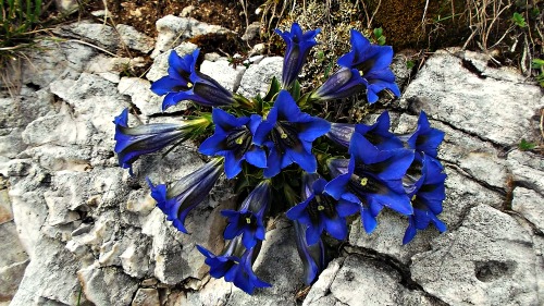
The area is also notable for its typically high-altutude Alpine flora; see above, for instance, a splendid image of Gentiana kochiana, taken in the vicinity of Rifugio Ütia Fodara Vedla.
The Fanes-Sennes-Braies Nature Park
Territory
The park confines to the north with the val Pusteria (Pustertal), to the west with the val Badia (Gadertal), while to the south the wide val Travenanzes marks the boundary between Alto Adige (South Tyrol) and Veneto. To the east, the Fanes-Sennes-Braies borders with the Tre Cime Nature Park – and more precisely with the val di Landro.
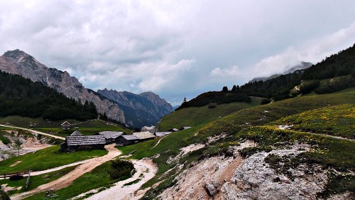
The peaks that dominate the vast plateaus of Fanes, Sennes, Fosses and Prato Piazza (Plätzwiese) reach altitudes of 3,000 m and beyond. This is a magical location (described in more detail below) with wide verdant meadows, suspended above the Braies valley. The park is also crossed by the Alpine Highways No. 1 and No. 3. The main accesses to the Fanes-Sennes-Braies park are via the two branches of the val di Braies (from the lake with the same name or from Ponticello); from the Val Badia (that is, from the village of San Cassiano in Badia/Sankt Kassian) or from the valley of Marebbe/Mareo, through the side valleys of Rudo and Tamersc, both radiating at the back of the village of San Vigilio di Marebbe/Enneberg.
Inside the Fanes-Sennes-Braies park there is also an old Austro-hungarian fort, dating to the First World War: the Prato Piazza fort.
Geology and Hydrology
The high plateaus of Fanes, Sennes and Fosses are delimited by peripheral rocks which then radiate on to the more external mountain slopes. These rocks are young and the succession typically starts with Main Dolomite; substantially, the park has a predominance of rocks dating to the Jurassic and the Cretaceous.
Important, in respect to the Dolomites as a whole, is the geomorphology of Fanes, Sennes and Fosses, strongly characterized by Karst phenomena – for example Karrenfelds (ridged fields), sink-holes and wells.
The main lakes of the park are: Lago di Braies, Lago di Dobbiaco, Le de Fojedöra, Lago di Limo, Le Piciodel and Le de Rufiedo (many of these names are in Ladin, as here we are at the centre of Ladinia – the region right at the heart of the Dolomites).
Main Peaks
The main peaks comprised within the Fanes-Sennes-Braies park include the Croda Rossa d’Ampezzo (3,146 m); Cima Cunturines (3,064 m); La Varella (3,055 m); Sasso di Santa Croce (highest peak: Cima Dieci, 3,026 m); Cima Fanis di Mezzo (2,989 m); Cima Nove (2,968 m); Monte Cavallo (2,907 m); Picco di Vallandro (2,839 m); Croda del Becco (2,810 m); Col Becchei (2,794 m); Monte Pares (2,396 m); Monte Serla (2,378 m); Monte Specie (2,307 m).
Fauna
In ancient times the park was frequented by different species of predators, such as wolf (the last reported specimen was killed in 1896), as well as lynx and bear, extinct since the 19th century (even though, in more recent years, there have been occasional sightings of passing bears). On September 23, 1987, Willy Costamoling – a well-known person from Corvara – during one of his walks bumped into the remains of what seemed to be an ancient species of bear, not previously known. This was indeed the case: Costamoling had found traces of the Ursus ladinicus (that is, the “Ladin bear”, so-called in honour of the region where it had been found – Ladinia – and of its proud people), whose remains were in a cave of the Conturines, at about 2,800 metres of altitude. In actual facts, the remains were not belonging to a single specimen, but it was a veritable ‘bear’s cemetery’, containing the rests of about 60 animals, besides some evidence of Panthera leospelaea – that is, the mythical “Lion of the Caverns” of popular imagination. The first analysis on the remains dated the bones to 50,000-40,000 years ago; following that, specific analysis have been carried out also on the DNA, thus discovering that, in all respects, it was indeed the case of a new species of cave’s bear (then named Ursus speleus). Its dimensions are estimated being just slightly inferior to those of the actual Grizzly bear; in particular, it was revealed that this bear was a herbivore.
The extensive conifer woodlands constitute one of the ideal habitats for Roe-deer (Capreolus capreolus); since a few decades deer has made its reappearance too. At the edges of woodland, instead, it is relatively easy to spot traces of badger and fox. To be noticed is also the presence of Marmot – the very symbol of the Fanes-Sennes-Braies park. This shy animal is quite widespread in the whole territory of the Nature reserve; its presence is easily told by the alarm whistles that it emits when sensing danger. Other species present in the park include: Chamois (Rupicapra rupicapra), Alpine Ibex (Capra ibex), the Highlander (or Highland cattle) – introduced not so long ago –, Alpine hare (Lepus timidus), European pine marten (Martes martes) and Stone (or Beech) marten (Martes foina).
The bird population includes: Black grouse (Tetrao tetrix), Hazel grouse (or Hazel hen; Tetrastes bonasia), Capercaille (Tetrao urogallus), Eurasian eagle-owl (Bubo bubo), Tawny owl (Strix aluco) and Golden eagle (Aquila chrysaetos). At the edges of the woodland also live Woodpeckers, Tits and Woodcock (Scolopax rusticola).
Flora
Rock and soil, together with altitude and micro-climates, determine flora biodiversity. The vegetation stages range from mountain forests near the valley floors to rocky regions at altitudes of 3,000 meters or more.
Forests: Most of the forests in Nature Park Fanes-Sennes-Braies/Fanes-Sennes-Prags consist of Spruce trees (Picea abies) that extend to altitudes of around 900 to 1,200 meters and that are supplanted by Larch (Larix decidua) and Cembra Pine (Pinus cembra) the closer one gets to the timber line. Scots’ Pines (Pinus sylvestris), which are relatively resilient, are found on the dry and gravely slopes of the Valle di Landro/Höhlensteintal and in the Val di Marebbe/Enneberg/de Mareo valley. The relatively sparse mountain forests contain abundant undergrowth, whose Bilberry (Vaccinium myrtillus), Bearberry (Arctostaphylos uva-ursi) and Alpine vegetation is attributable to the presence of acidic humus soil. The knee-timber zones that characterize sparse mountain forests often abound in Dwarf Mountain Pine (Pinus mugo), whose up to ten meter long and highly ramified root systems are instrumental in solidifying steep slopes and scree.
Mountain Meadows and Pastures: Much of the Fanes-Sennes-Braies/Fanes-Sennes-Prags Nature Park is covered with mountain meadows and pastures comprising extremely bio-diverse habitats whose existence is attributable to the historic human use of these areas. Dry zones of extensively used mountain meadows contain – amongst the many present – plants such as Arnica (Arnica montana), some species of Gentian (Gentiana sp.), various Orchid genera (including Orchis, Ophrys and Dactylorhiza), and other plants like Common Bistort (Persicaria bistorta) and Golden Hawksbeard (Crepis aurea). If these pastures are grazed too heavily, plant formations like hassocks and species as Mat-grass (Nardus stricta) – that are unfazed by being trampled on and are not to the liking of bovines – tend to take over.
Alpine Meadows and Scree: More or less self-enclosed pastures or pasture communities occur at altitudes of 2,000 to 2,800 meters above sea level. The calcareous grasslands of the Dolomites are composed of perennial grasses and sedges (Carex sp.), whereby Mountain Avens (Dryas octopetala) and Carex firma are also common. Likewise, widely distributed in the Dolomites are plants such as Dragonmouth (Horminum pyrenaicum), Dolomite Yarrow (Achillea oxyloba), Globe Daisy (Globularia sp.) and – in some areas – Edelweiss (Leontopodium alpinum). Debris cirques, which often penetrate far into the valley floors, serve as habitats for a number of “specialists”, such as yellow Alpine Poppy (Papaver alpinum), Alpine- and Round-leaved Pennycress (Thlaspi caerulescens and T. rotundifolium).
Rock Crevices: Only “specialist” flora is able to survive in rock crevices or on bare rocks. These plants include various cushion plants, and some other Dolomite 'staples' such as Devil’s claw (Physoplexis comosa), Edelweiss (Leontopodium alpinum), Cinquefoil (Potentilla nitida), Alpine Androsace (Androsace alpina), Pale Corydalis (Corydalis solida) and Blue-green Saxifrage (Saxifraga caesia).
Structures in Service of Tourism
In San Vigilio di Marebbe/Sankt Vigil in Enneberg a visitor centre for the Parco Naturale Fanes-Sennes-Braies (Nature Park) has been built, which is free to visit and collects in an atmospheric wooden building information and curiosities about this territory. Here the visitors can obtain information on the environment, geology, paleonthology, human endeavors/activities within the Fanes-Sennes-Braies. The centre can be visited Tue to Sat from May to Oct, and again from Dec to March.
Inside the park also exist several Rifugi alpini (Alpine huts). These are: Rifugio Pederü (1,548 m); Rifugio Lavarela (2,042 m); Rifugio Sennes (2,126 m); Rifugio Ütia Fodara Vedla (1,966 m; see picture below); Rifugio Fanes (2,062 m); Rifugio Scotoni (2,040 m); Rifugio Vallandro (2,040 m). All these mountain huts will be described in more detail below.
The Fanes-Sennes-Braies (Fanes-Sennes-Prags) Nature Park features prominently also in the thematic trails known as ‘Culturonda Dolomythos’: a series of 12 cultural routes – devised by the province of Bolzano/Bozen – which contain all the main features that can be admired in South Tyrol, divided by theme.
Noteworthy Locations Within the Park
Prato Piazza
Geography
By the pass bearing the same name extends the Prato Piazza plateau (Plätzwiese) – one of the most famous locations of the Dolomites inside the Parco Naturale Fanes-Sennes-Braies. The plateau extends at an altitude of about 2,000 m and it is now under the protection of the UNESCO because of its precious Alpine ecosystems and the panorama that can be enjoyed from there. Form the plateau, in fact, it is possible to admire the Croda Rossa d'Ampezzo (3,146 m), the Tre Cime di Lavaredo/Drei Zinnen (2,999 m), the Tofane (3,244 m) and Monte Cristallo (3,221 m).
Besides, Prato Piazza plateau lies also the at the base of the Picco di Vallandro (2,839 m) and Monte Specie/Strudelkopf (2.307 m). The plateau can be reached either via a tarred road from Braies or, from the south, by a dirt road from Carbonin.
Places of Interest
The Prato Piazza plateau is not permanently inhabited; however, there are a hotel and an Alpine hut – the Rifugio Vallandro (Dürrensteinhütte; 2,040 m) – where it is also possible to have accommodation. At the southern fringe of the plateau are the ruins of Forte Prato Piazza – the sole remains of a small fort once belonging to the Austro-hungarian Empire.
Prato Piazza is today a place heavily frequented by tourists, much appreciated both in summer and in winter; yet, for all the crowds that visit it, it is not difficult to find peace in it at any time, thanks to its vastness. During the summer, it is the departure point for numerous excursions in the area – amongst which is the famous trail that takes to the summit of Picco di Vallandro (2,839 m). In the winter season it is also possible to practice Nordic ski, as the snow is nearly always quite abundant during those months, given the plateau's high altitude.
During the summer months, the road from Ponticello to Prato Piazza becomes a toll-road, while in winter access is not regulated and it is possible to drive up freely, but solely when equipped with proper winter tyres or car chains.
Sasso di Santa Croce
General Description
The Sasso di Santa Croce (Kreuzkofel; Sas dla Crusc in Ladin) is a mountain of the Dolomites belonging to the group of the ‘Dolomiti Orientali di Badia’ (Eastern Dolomites of Badia), which dominates the Val Badia with its vertical cliff almost 900 m long.
The Sasso di Santa Croce is part of the mountains of the Alpe di Fanes Piccola. The most elevated peak is Cima Dieci (Ladin: Piz dales Diesc), which reaches 3,026 m, while the most known summit is perhaps Monte Cavallo (Heligkreutzkofel; Ladin: L’Ciaval), 2,907 m. Another important peak of the group is Cima Nove (2,968 m).
The main access to the mountain is through the Passo di Santa Croce (2,612 m), which can be reached either from Rifugio Fanes (2,062 m) and Rifugio Lavarella (2.042 m) on one side, or from the Ospizio di Santa Croce/Heligkreutz – Santa Croce Hospice, situated high above Pedraces in Val Badia – on the other, by using the Via ferrata (iron way) of Monte Cavallo.
Name
The name of the mountain, Sas dla Crusc, derives from the Ladin. In fact, the word ‘sas’ should be rendered in Italian with ‘mountain, mount’, not ‘rock’ or ‘stone’; the correct translation in Italian would therefore be “Monte della Croce”. An analogous case happens for the Italian names of Sassolungo/Langkofel (3,181 m) and Sassopiatto/Plattkofel (2,685 m). The second part of the name derives instead from the Ospizio (or Santuario) di Santa Croce/Heligkreutz, which lies at the foothills of the mountain.
The Ladin name prior to the foundation of the sanctuary, and therefore more ancient – Sas Vanna – was deeply connected to the mythical Kingdom of the “Regno dei Fanes” (for more information on this, see the page on Legends of the Dolomites).
Some Itineraries
1) Lago di Braies – Le de Fojedöra – Lago di Braies
Complete round-trip: 6/7 hours; 800 m of altitude difference; difficulty: medium.
From the Lago di Braies (1,520 m) one reaches its southern shores along trail marked No. 1, at the foot of the Croda del Becco (2,810 m). Once reached a small bridge, one takes the path marked No. 19 that enters the woodland then leads in a short while to the hut called ‘Malga Foresta’ (30 min), where it is possible to see some grazing animals, amongst which are also a few specimens of Highland cattle.
As one continues along the trail, one will enter the val di Foresta (Grünwaldtal), until reaching a clearing with a wooden cabin, where normally a few animals (most notably deer) gather to graze. The first junction is to be found here, and at this location one can take the trail that climbs on the right, while the return route will be with the path on the left (marked No. 25), which comes from the valle dei Larici (Lärchental).
At this point the proper rise starts, until reaching the so-called Capanne di Fojedöra (Fojedöra huts; 2,114 m); subsequently, in about half an hour, one can reach the Le de Fojedöra (Lago dell’Alpedei Colli Alti; Hochalpen-See, 2,252 m), from where one can admire the surrounding peaks of Piz da Peres (2,507 m) and the Punta Tre Dita (2,479 m).
From the Fojedöra lake one can then take the trail marked No. 24, which with little difference in altitude will lead to the junction between the valle dei Larici and the val de Ciastlins, past a small mountain pass. From there one takes the path that re-descends along the valle dei Larici (marked No. 25), which offers an interesting panorama over the Croda del Becco (2,810 m) and the Muntejela de Sennes.
With the trail marked No. 19 one eventually regains the junction already encountered previously, and in a short while one will get back to the Lago di Braies.
2) Capanna Alpina – Rifugio Fanes – Rifugio Pederü
Complete round-trip: 4/5 hours; 600 m of altitude difference, difficulty: medium-easy.
Starting from the Capanna Alpina (1,732 m), in the upper valley of San Cassiano, one proceeds on trail marked No. 11, initially quite steep, to then reach in about 1 h a first, pleasant panoramic point by the Col de Loćia (2,069 m). From there, looking behind, one can appreciate the panorama on the Sella group, with its highest elevation of Piz Boè (3,152 m). By continuing along the same path, one sees on the left the Cima Cunturines (3,067 m) and the Piz de La Varela (3,056 m), while to the right are Monte Ciaval (2,914 m), Monte Casale (2,898 m) and the Furćia Rossa (2,796 m), where the ‘Sentiero della Pace’ (described below) also passes through. Within another hour one arrives at the Malga di Fanes Grande (2,110 m), at whose back one can admire the Col Bechei (2,796 m).
Always proceeding along path marked No. 11, one rises for about 20 minutes more, and reaches the beautiful Lago di Limo (2,154 m). As one continues walking, a beautiful panorama opens up that offers the excursionist a wide vision on the surrounding Dolomite peaks: the Sasso delle Nove (2,971 m), Sasso delle Dieci (3,026 m) and the Piz De Sant’Antone (2,656 m). Further on still, one arrives at a cross, from where one can glimpse Rifugio Fanes (2,062 m) and Rifugio Laverella (2,038 m), surrounded by a well-known amphitheatre of rocks – the so-called “Parliament of the Marmots”. Up to Rifugio Fanes, the route so far is of approximately 9 km – which can be covered in about 2 hrs and 40 minutes – with an altitude difference of circa 600 metres.
From there, one can then take the path marked No. 7, which takes one to Rifugio Pederü (1,577 m) through the valle Rudo (in about 1,5 hours) and descend towards San Vigilio di Marebbe.
3) The “Via della Pace”
The so-called “via della Pace” is a long, equipped trail with some sections of ‘via ferrata’ (iron way). By starting from the Malga di Fanes Grande (2,110 m) one follows the path marked No. 17 towards the south-east, to then reach in about 2 hours the ‘Bivacco della Pace’ (2,758 m). From there, the trail continues uphill, following the tracks opened by the Austro-hungarian soldiers during WW1. After roughly 1 h one arrives at the top of Furcia Rossa (2,796 m), from where one proceeds further towards the north, with the possibility to return to the starting point in 1,5 hours.
In total, this route can be covered in 5/6 hours, by confronting an altitude difference of about 900 metres; along the trail there are well visible war positions built by both the Austrian and the Italian troops during WW1.
4) Sentiero dei Larici/Lärchensteig Interpretive Nature Trail in S. Cassiano/St. Kassian
This interpretive nature trail, which is known simply as “Sentiero dei Larici”/Lärchensteig and extends from Höfen Rüdeferia to Rü farmhouses above S. Cassiano/San Ciascian in Val Badia/Abtei, also forms one of the boundaries of the Fanes-Senes-Braies/Fanes-Sennes-Prags Nature Park, and features interactive stations containing information, pictures and games for visitors’ edification and entertainment. The trail can be walked in either direction, depending on which of the aforesaid farmhouses you start from. As the trail is only about one kilometer long, it is not very demanding, and thus particularly suitable for families with kids. The trail has two stations offering general information and seven stations featuring more specific information.
The trail’s main theme comprises the various types of landscapes such as larch fields/meadows that have been created through human intervention, as well as the forests and watercourses and their natural and man-made characteristics.
The trail’s main attraction is a working mill known as Mill of the Farmhouse Rüdeferia, whose restoration was funded by the local tourist office, the town of Badia/Abtei and the provincial office for nature parks. The mill – which is now a protected landmark – works perfectly, and is open to the public during the summer months via the weekly guided interpretive nature trail tours that are organised by the tourist office and conducted by local guides.
5) Capanna Alpina (1,729 m) – Col de Locia (2,069 m) – Malga Gran Fanes/Großfanes-Alm (2,110 m) – Lago di Limo/Limosee (2,159 m) – Rifugio Fanes/Faneshütte (2,060 m) – Lake Lago Piciodel /Piciodelsee (1,820 m) – Rifugio Pederü/Ücia de Pederü (1,544 m)
If you follow the road to Valparola Pass from S. Cassiano in Badia/St. Kassian im Abteital for around three kilometers, you will reach the turnoff to Capanna Alpina (1,729 m), where you take the trail, located to the right of the existing gravel pit, that leads to Capanna Alpina (no. 11). Then keep following trail no. 11, which leads you through spruce forests and the small pastures of Plan de Furcia. The path, which becomes steeper here, leads you to Col de Locia (2,069 m). The next section of the trail leads through the enclosed hollow between the cliffs of the Fanes and Camperstrin mountain groups, as well as Les Conturines hollow. You will then reach Ju dal’Ega. Continue on the trail (which here is level) through the Alpine pastures of Fanes to Großfanes Alpine pastures (2,110 m) by the Malga Fanes Grande/Großfanes-Hütte – a hike of around three hours. Then follow the trail’s gentle slope upward to Limosee lake, which is also the highest point of the hike (2,159 m). After descending to Rifugio Fanes/Ücia de Fanes, follow trail no. 7 from the refuge, which leads down to Lè Piciodel lake. After a relatively steep descent, the hike ends at Rifugio Pederü/Ücia de Pederü (1,544 m), in the Val di Marebbe/Enneberg /Val de Mareo.
6) Prato Piazza/Plätzwiese (1,976 m) – Sella Monte Specie/Strudelkopfsattel (2,212 m) – Monte Specie/Strudelkopf (2,308 m) – Rifugio Vallandro/Dürrensteinhütte (2,031 m) – Prato Piazza/Plätzwiese (1,976 m)
From the Prato Piazza/Plätzwiese parking lot (1,976 m), follow the trail to the inn called Plätzwiese Gasthaus. From there, follow hiking trail no. 40 toward Vallandro/Dürrenstein, and after a 20 minute walk you will reach trail no. 3. Turn left and follow the markers in the direction of Dürrensteinhütte (path no. 37). Shortly before you reach Dürrensteinhütte refuge, you will come upon a forest road. From there take path no. 34, which will lead you to Strudelkopfsattel (2,212 m), from where you can see the summit cross. From the top of Strudelkopf (2,308 m) there is a superb panoramic view of the surrounding peaks and mountain chains such as the Sesto Dolomites/Sextner Dolomiten, the Cadini group, the Marmarole, the Cristallo mountain group and the Croda Rossa/Hohe Gaisl. After descending to Dürrensteinhütte refuge (2,031 m), take the forest road back to the starting point. Note: During the summer you can also park at Ponticello/Brückele and take the bus to Gasthaus Plätzwiese (1,976 m).
7) Badia/Abtei (1,340 m) – Chairlift summit station (1,836 m) – Santa Croce/Heilig Kreuz (2,043 m) – Sura Valgiarëi (1,786 m) – Pedraces/Pedratsches (1,340 m)
Take the chairlift from Badia/Abtei and arrive at 1,836 meters above sea level, from which Heilig Kreuz (2,043 m) is around a 30 minute hike (path no. 7). Take the Via Crucis trail no. 15 towards Armentara across wet meadows and rough pastures. After leaving the dirt trail, turn left onto trail no. 15A. Turn left at the next junction, which is located amongst intensively used pastures that are nonetheless replete with flowers. The meadow trail now ascends (for the last time) to Prè Comun. Before you descend, take a few moments to appreciate the magnificent flowers, whose colours vary according to the season; whether the anemones and gentians are in bloom or past their prime, whether larches are green or golden, this is always a lovely spot to spend a few moments. At the Valacia hollow, you will see a small moor pool (Sura Valgiarëi, 1,786 m), and if you look closely you may observe various life forms: frogs and toads lay their eggs here in spring, while Alpine newts and insects can be observed during the summer. The descent from Valacia and Razuns to Hof Ćialaruns is a short, very easy hike. After the final segment of the hike, turn left into path no. 7A, and you will reach your starting point in around 45 minutes.
Mountain Huts in the Fanes-Sennes-Braies Nature Park
“Leave the footpaths, immerse yourself in the environment and in the silence; walk slowly, far away from daily thoughts, and discover the treasures of these magnificent mountains.”
Over the years many people have contributed to build these wonderful mountain huts located in peaceful basins or in dramatic places, and perfectly suited as starting point for many hiking excursions in the Dolomites. Here you will enjoy the traditional friendliness that has always characterised these lovely spots amidst green Alpine pastures and conifer trees; the magical environments – full of memories from the past or painted with the colours of the many myths and legends – further contribute to create mysterious or fairy-tale atmospheres. Also, on a more practical note, you will get a chance to savour delicious Ladin dishes in the comfortable wooden Stuben, and you will have the rest you need after a long mountain walk, or before facing the challenge of a ‘via ferrata’. Either way, these unique spots – full of little miracles of nature – will ensure you have an unforgettable pause or stay.
Rifugio Pederü
The Rifugio Pederü (Ücia Pederü in Ladin) is an Alpine hut situated in the Parco Naturale Fanes-Sennes-Braies in South Tyrol, at 1,548 m. By the Rifugio passes also the Alta via (Alpine Highway) no. 1.
The Rifugio is easily reached via the road that takes one from San Vigilio di Marebbe/St. Vigil through the val di Rudo (Rautal), in a south-easterly direction.
History
Since WW1 the end of the Val di Rudo had been occupied by the military, as the road that crosses it performed the important function of linking this area to Rifugio Fanes and Rifugio Sennes. In this location, a few wooden shacks started to be built; these were part of a small village, predominantly lived in by artisans. Here were also the camps for the Kaiserjäger (literally, the Emperor’s hunters), together with a leper hospital, a cemetery and even a water reserve. In order to maintain the connections, dedicated cable-ways and a telephone line were also installed.
During the 1920s the Kingdom of Italy gave permission to demolish what was left of the old military village. A few huts, however, were left in place, and one of them actually became the Rifugio; the others were turned into storehouses or deposits. From 1935, the small wooden hut belonging to the officials was transformed into a stone building, which was only completed after the end of WW2, when the Rifugio started to be lived in by the proprietors.
From 1953 onwards, a few guestrooms were made available and rent out; then in 1959 the living room was erected, together with the first hydro-electric plant. Additional developments of the Rifugio followed in later years, and since 1975 the hut is open in both seasons – summer and winter.
Access
It is possible to reach the Rifugio from:
· San Vigilio, by walking through the val di Rudo;
· Rifugio Sennes, by passing via Rifugio Fodara Vedla;
· Rifugio Fanes, with trail no. 7, in 1,30 h.
Rifugio Fanes
The Rifugio Fanes (Fanes-Hütte; Ütia de Fanes in Ladin) is an Alpine hut situated in the Parco Naturale Fanes-Sennes-Braies in South Tyrol, at 2,062 m, by the Alpe di Pices Fanes (‘Fanes Piccola’), along the old military track that connects the Rifugio Pederü to Cortina d’Ampezzo. The Alpine hut is located in the municipality of Marebbe/Enneberg.
History
Just after the end of WW1, the first motor cars began to enter the upper Valle di Marebbe, thus causing the numbers of tourism to rise, but it was not until 1928 that the Rifugio was finally built. The Rifugio was, for the first few years, a dépendance of the Hotel Posta; subsequently, the building was enlarged and became self-standing only in 1938. After WW2 reaching the hut – and providing for its needs – became easier, thanks also to the exploitation of the energy from a nearby torrent, which allowed the use of electricity. In 1996, a new refurbishment saw the installation of solar panels.
Characteristics and General Information
The Rifugio is open both during the summer season – from the beginning of June to mid-October – and during the winter, from mid-December to mid-April.
Beside the Rifugio Fanes is the Rifugio Lavarella – only about 500 metres to the west.
Rifugio Fanes is easily reached from Rifugio Pederü (1,548 m), either along the path marked No. 7 or with authorised vehicles along a dirt-road parallel to the trail. Finally, for the guests of the Rifugio, free transportation to the hut is also offered with a jeep or snow-cat, in order to reach it in winter time.
Other possible ways to access the Rifugio are from the Capanna Alpina (San Cassiano side), or from the Lagazuoi/Passo Falzarego area.
Rifugio Lavarella
The Rifugio Lavarella (Lavarellahütte; Üćia Lavarella in Ladin) is a Rifugio situated in the Parco Naturale Fanes-Sennes-Braies in South Tyrol in the Alpe di Pices Fanes (‘Fanes Piccola’), at 2,042 m. It is located along the old military track that connects Rifugio Pederü to Cortina d’Ampezzo. The rifugio is within the municipality of Marebbe/Enneberg.
History
Before WW1, in this location existed solely a hut. In 1919, this building was enlarged with materials taken from the war fields, and transformed into a Rifugio (mountain hut) for mountaineers and excursionists; following another expansion, the Rifugio burned down in 1939. During WW2 a new Rifugio was built, which was eventually refurbished in 1997.
On a note of curiosity, during the 1980s part of the hut was hit by mistake by bullets during a military training operation in the area, and the signs are still visible.
Geography
Near the Rifugio Lavarella there are:
· 500 metres to the east is the Rifugio Fanes;
· Just a little to the south is the small, atmospheric Lago Verde;
· Beside the Rifugio is found also the Picia Capela de Fanes – a tiny chapel erected in 2003 in dedication to the local saint and missionary from Oies, Joseph Freinademetz.
Access
The Rifugio Lavarella is easily reached from Rifugio Pederü (1,548 m), either along trail no. 7 or with authorised means of transportation along a dirt road, which runs parallel to the trail.
Other possible ways of accessing the hut are via the Capanna Alpina (San Cassiano side), or from the Lagazuoi/Passo Falzarego area.
Rifugio Sennes
The mountain hut Rifugio Sennes
(2,126 m) is located in the Fanes-Senes-Braies Nature Park and offers a
wide panorama over some of the most beautiful peaks of the Dolomites, including Croda Rossa (Hohe Gaisl; 3,146 m), Cristallo (3,221 m), Sorapis (3,205 m) and Tofana (3,243 m).
Access
From S. Vigilio/St. Vigil by car or bus to the Rifugio Pederü, 12 km; from Rifugio Pederü turn left (path marked No. 7, or Dolomites Highway No. 1) and continue for about 5,5 km; 2 h walk.
Alternatively, from S. Vigilio/St. Vigil by car to the Lago di Limo (the ‘Chalk Lake’, so-called for the milky colour of its waters); then for about 3 km on the paths marked Nos. 25-24 up to Ciastlins-Sennes gap (Forcella Sennes) and down to Rifugio Sennes (4/5 hrs).
From Cortina d’Ampezzo by car or taxi to the alpine pastures of Ra Stua (where the mountain hut Rifugio Malga Ra Stua is also situated); from there to the Val Salata (the ‘salted valley’; probably as it was used by those carrying salt) on the path marked No. 6 for about 5.5 km; 2 h walk.
From Braies Lake with path marked No. 23, or Dolomite Highway No. 1; approx. 4/5 h walk.
The Rifugio Sennes
was built between 1937 and 1939. It was inaugurated in the 1940s and
since then it has always been open, in summer as well as in winter.
However, 1962 was the year of great changes: a spring was found below
the Col de Riciogogn peak, at 2,550 m; a pipe nearly 4 km long was laid down, an electric generator and
heating system were installed and at the same time was traced the road that since then makes the Sennes lodge reachable to jeeps. In
1985 the hut was enlarged and a lot of works were carried out until it
became how you see it today.
The Rifugio Sennes is the ideal
accommodation for climbers, hikers and families who will be able to
appreciate the tranquillity and live close to an uncontaminated nature.
In winter this place changes into a paradise for skiers, where they can
find alternatives to Alpine skiing, best opportunities for
ski-mountaineering, cross-country skiing (with a ring of approx. 3 km)
and snowshoeing.
Rifugio Fodara Vedla
Position of the Rifugio
The mountain refuge Rifugio Fodara Vedla (Ütia Fodara Vedla in Ladin)
is located at the heart of the Nature Park Fanes-Senes-Braies, which
falls almost entirely in the administrative area of San Vigilio di
Marebbe/Enneberg. The vast, green basin – situated at roughly 2,000 metres above sea level – is traditionally used as mountain pasture in the summer and is surrounded by the marvellous peaks of the Dolomites.
To access the mountain hut from San Vigilio/St. Vigil, you may use public or private means of transportation to Rifugio Pederü. From Rifugio Pederü (1,545 m) you can then reach the mountain hut on foot with about 1 h and 15 min. by taking the 3 km long path marked number 7.
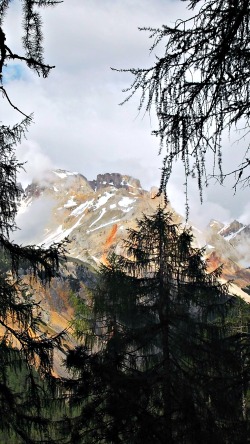
From Cortina d’Ampezzo you may use public or private means of transportation to Rifugio Malga Ra Stua (around 1,700 m); from there, walk for about 5 km along path marked number 9 on a former military road that rises with hairpin bends, and you will reach Rifugio Fodara Vedla within 1.30 hrs (see above a picture of the Croda Rossa/Hohe Gaisl, as it appears from this trail).
From Lake Braies (Alta Val Pusteria), at about 1,600 m, you can reach Rifugio Fodara Vedla within approximately 5 hrs along path marked number 23 or with the Alta via (Alpine Highway) No. 1.
A Traditional Dwelling in the Dolomites
The mountain hut Rifugio Fodara Vedla dates back to the era before the First World War, when the Austrians – who administered the area at the time (as it was still part of the Empire) – built a little village made of wooden cabins on the plateau which carries the same name.
Once WW1 was over, the hut was bought from the soldiers and turned into a summer house – at the beginning just for the buyer’s family. In 1936 board and lodging was offered for the first time to guests, who were starting to spend their holidays in the area. For this purpose, the house was fitted with beds and central heating.
With the arrival of WW2 this activity came to an end. In 1947 the little chapel of Saint Anthony – the protector of cattle – was built a short distance away. After that, efforts were not spared to make the Rifugio a most comfortable and beloved mountain hut for the growing number of guests and walkers visiting the area.
Today's building dates back to 1979, when guest rooms of different guises were properly fitted. The old part of the Rifugio still offers further – albeit more basic – sleeping accommodation to this day.
Rifugio Scotoni
Surrounded by enchanting mountains as it is, just give yourself time to admire the beautiful views that surround the Rifugio Scotoni (2,040 m), which will literally take your breath away.
Geography
This mountain hut is the starting point for many adventurous excursions and fixed rope routes (vie ferrate). For example, you can reach the Lago di Lagazuoi (Lake of Lagazuoi) by walking along the path at the feet of the Scotoni peak (Cima Scotoni, 2,874 m). Hikers with more expertise can undertake something more challenging instead – namely, the well-known fixed rope route Tomaselli (via ferrata Tomaselli), at the southern edge of the Alpe di Fanes (altitude between 1,545 and 2,165 m). Some of the many possible excursions from Rifugio Scotoni are succintly described below.
Excursions and vie ferrate (Fixed Rope Routes):
1. Rifugio Lagazuoi – Rifugio Scotoni: 4,5 km; 1 h 30; signposts: AV 1 (Dolomite Highway no. 1), CAI marked path No. 20; easy.
2. Rifugio Scotoni – Le de Lagaciò (Lake of Lagazuoi): 1 km; 0,40 min; CAI marked paths Nos. 20/20B; a short, easy walk suitable for all.
3. Rifugio Scotoni – Monte Casale: 10 km; 5 h 20; CAI marked paths No. 20/17 and AV1 (Dolomite Highway no. 1); a long excursion, but easy.
4. Rifugio Scotoni – Rifugio Fanes: about 10 km, 3 h 20; CAI marked path No. 20 and AV1 (Dolomite Highway no. 1); a long excursion of medium difficulty.
5. San Cassiano (locality Sciarè) – Rifugio Scotoni: 3,200 km; 1 h 10; CAI marked paths Nos. 11/20; easy.
The First World War in South Tyrol
The surroundings of Rifugio Scotoni were the theatre of many WW1 events. In fact, in this area sinister battles between the Italian and Austrian armies took place, and today you can still see the tunnels that the soldiers dug to look over and defend the front lines. One can also visit the small chapel in honour of all war victims and take the opportunity to learn more about this aspect of the history of the Dolomites.
The First World War Ski Tour
In winter time, the First World War ski tour allows for a completely different take altogether on such a tragic event in the history of Europe. 80 km of routes combine history and nature – including the Pralongià high plane ski run, with views over the Marmolada glacier – along perfectly prepared slopes. The unique Dolomite landscapes are – in and of themselves – quite an experience: this, in a nutshell, is the essence of the Great War Ski Tour.
Rifugio Vallandro
History
This Rifugio is quite distanced from the previous ones, as it is located at the other extremity of the Fanes-Senes-Braies Nature Park, in comparison to the mountain huts just described (that is, at the easternmost sector of the nature reserve); nevertheless, this area is highly worth a visit. The construction of Rifugio Vallandro was started in 1968 by using some dismissed ex-huts built by the Austro-Hungarian troops and dating to WW1. Its completion was retarded by the finding of an unexploded bomb; it was finally inaugurated in the summer of 1970. In 2002 there was an enlargement and refurbishment of the Rifugio.
Characteristics and information
The Rifugio is open both during the summer and the winter season. The Rifugio is near a majestic mountain tree in the locality of Prato Piazza, where is also found the fort bearing the same name.
Access
The Rifugio is mainly accessible via:
· Ponticello, in the valle di Braies, with trail No. 37, in 2 hrs;
· From Carbonin, in the valle di Landro, with trail No. 37, in 2 hrs;
· From Landro, in the valle di Landro, with trail No. 24, in 3 hrs.
Excursions
· Picco di Vallandro (Dürrenstein; 2,839 m), with trail No. 40, in 2,30 hrs;
· Monte Specie (Strudelkopf; 2,308 m), with trail No. 34, in 1 hour.
The Role of Nature Parks
The main objectives of the Fanes-Sennes-Braies nature park include:
– the preservation of natural and cultural landscapes;
– to contribute towards a comprehensive knowledge of the area covered;
– to convey an understanding of nature, and finally;
– to guarantee an orderly development of recreational activities.
This Nature Park is part of Natura 2000, a Europe-wide network of conservation areas with the goal to protect the natural habitats, including flora and fauna. Due to its geologic and geo-morphological importance – as well as its scenic beauty – the Fanes-Sennes-Braies Nature Park has also been accepted into the UNESCO World Heritage List as part of the Dolomites UNESCO serial site, and can thus be counted as one of the most spectacular mountain landscapes in the world.
The Decision of the UNESCO, World Heritage Committee
On the 26th June 2009, at its 33rd session held in Seville, the World Heritage Committee unanimously accepted the Dolomites’ application, with the conditions laid down by the IUCN. What follows is an abstract from the declaration on the outstanding universal value of the Dolomites:
“The nine components of the Dolomites World Heritage property form a series of highly distinctive mountain landscapes that are of exceptional natural beauty. Their dramatic vertical and pale-coloured peaks in a variety of sculptural forms is extraordinary in a global context. These mountains are also of international importance for the Earth Sciences. The quality and concentration of highly varied carbonate formations is unique in the world, whilst the superbly exposed geology provides an insight into the marine life of the Triassic period, which developed after the greatest species’ extinction recorded in the history of life on earth. The sublime, monumental and colourful landscapes of the Dolomites have also long attracted hosts of travelers and were the source of numerous scientific and artistic interpretations”.
The inclusion of the Dolomites in the World Heritage List is an extraordinary form of recognition, but it also implies a strong commitment and responsibility for the safeguarding and sustainable development of this beautiful mountain region.
The United Nations Educational, Scientific and Cultural Organization (UNESCO) seeks to encourage the identification, protection and preservation of cultural and natural heritage sites around the world, through locations considered to be of outstanding value to humanity. These universally significant sites are entered into the UNESCO World Heritage List. So far (as of 2011), 936 sites have been recognized worldwide; of those, 183 are natural sites and 753 are cultural or mixed sites.
Return from Dobbiaco to South Tyrol
Return from Fanes-Sennes-Braies to Italy-Tours-in-Nature
Copyright © 2021 Italy-Tours-in-Nature

New! Comments
Have your say about what you just read! Leave me a comment in the box below.