- Italy Tours Home
- Italy Ethos
- Tours 2023
- Blog
- Contact Us
- Dolomites
- Top 10 Dolomites
- Veneto
- Dolomites Geology
- Dolomiti Bellunesi
- Cortina
- Cadore
- Belluno
- Cansiglio
- Carso
- Carnia
- Sauris
- Friuli
- Trentino
- Ethnographic Museums
- Monte Baldo
- South Tyrol
- Alta Pusteria
- Dobbiaco
- Emilia-Romagna
- Aosta Valley
- Cinque Terre
- Portofino
- Northern Apennines
- Southern Apennines
- Italian Botanical Gardens
- Padua Botanical Garden
- Orchids of Italy
Livinallongo (Fodòm): a Community in the Heart of ‘Ladinia’, in the Shadow of the Sella Group.
The small sub-region of Livinallongo lies at the very head of the Agordino region, and it can be reached in three different ways.
From Caprile and the south, one simply continues along the main axis of the Cordévole to the upper reaches of its valley, thus entering the municipality of Livinallongo del Col di Lana (also known as ‘Fodòm’ in the local Ladin variant), which forms part of a small section of the Province of Belluno where Ladin is still spoken.
Together with Colle Santa Lucia (see below) and Cortina d’Ampezzo, these three communities were part of Tyrol until as late as 1923 – and a few centuries of Austrian rule have left their mark, culturally as well as in the regular attempts of these municipalities to re-enter South Tyrol (present-day province of Bolzano/Bozen), which borders the area to the north.
Livinallongo is also one of the five so-called Ladin valleys that radiate in all directions from the central massif of the Sella (3,152 m), part of a cultural region usually defined as Ladinia.
A Heritage Reflected in the Vernacular Architecture
As a matter of fact, as soon as you enter Livinallongo you can feel the difference: permanent homes and farms reach much higher altitudes than anywhere else in the province – and that calls immediately to mind the ‘masi’ (Höfe) of South Tyrol: isolated farmsteads – in many respects self-sufficient units – that are perhaps the most defining feature in the landscape of German-speaking Alpine communities.
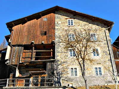
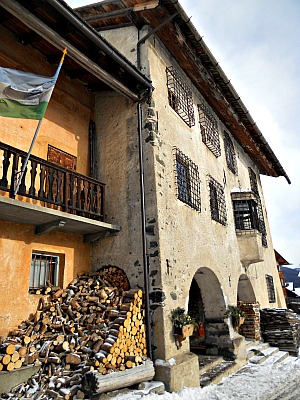
Most hamlets of the municipality of Livinallongo del Col di Lana display very interesting examples of vernacular architecture too: the Fodòm type (the Ladin name of the area) presents houses almost neatly split in two (see picture below).
The Typologies of vernacular architecture
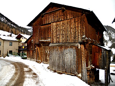
One half of the house is in wood (normally the part dedicated to the barn, and to the shelter of animals), while the other half – inhabited by people – is in stone and usually painted white, facing south whenever possible to make the most of sunlight. Ornella, Andràz (see below) and Cherz are also the highest permanent settlements in the Province of Belluno.
The peculiar, intriguing history of this community is told in the small but captivating “Museo della Gente Ladina” (the ‘Museum of the Ladin People’) in Pieve di Livinallongo, which displays more than 600 objects and photographic documents on local history, customs and traditions. Activities such as hay-making – in an area renowned for the steepness of its slopes – are well documented, while in Ornella one can still visit an old mill and a smithy.
Here and there, some old wooden stacks for drying broad beans – one of the few crops to grow at such an altitude, and therefore a traditional staple food – can also still be admired, but now they stand largely unused.
The Great Dolomite Road and Pieve di Livinallongo
The other two main accesses to Livinallongo are through the Great Dolomite Road – “La Grande Strada delle Dolomiti” – that crosses the whole area longitudinally: a scenic route that was traced in 1909 to connect Cortina with Bolzano through a series of spectacular high-altitude passes.
Pieve di Livinallongo (1,470 m) – the main centre – is situated roughly in the middle of the municipality, so it can be taken as a good reference and starting point from which to explore the rest of the territory. It also lies half-way along the Great Dolomite Road.
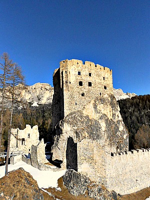
Coming from Cortina d’Ampezzo and the Passo Falzarego (2,105 m), before reaching Pieve the road passes the Castello di Andraz (see image below) – a castle which is cited in a document for the first time in 1027. This was originally a possession of the Prince Bishops of Bressanone/Brixen in South Tyrol, from whom the area depended.
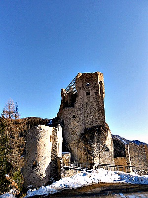
Situated in an unusually high – but sheltered at the same time – location, the castle was part of a system of fortifications for the control of the area. The Prince Bishop himself often took shelter here, and kept the castle until as late as 1853.
Unfortunately, it was later abandoned and it is now in ruins – but these ruins were carefully restored recently, and this fact, combined with the location, makes for quite a unique visit.
Continuing westward past Pieve di Livinallongo, one crosses the elevated ski resort of Arabba, eventually reaching the Pordoi pass (2,239 m), which is the highest point along the Great Dolomite Road – and also one of its highlights before entering Trentino.
The cable car to Sass Pordoi (3,002 m), very popular and unimaginably crowded in summer, takes you nonetheless to one of the most breathtaking viewpoints in the whole Dolomites’ region.
From there, an immense view opens up on all the Dolomites highest peaks, from the Catinaccio/Rosengarten to the Sassolungo/Langkofel; from the Sorapiss to the Antelao.
The surrounding mountains (namely the Col di Lana, 2,452 m; a toponym that could be roughly translated in English as “Woolen Mount”) are sadly famous for their association with bitter fights during World War I – and indeed, as anticipated before, it is only at the end of the hostilities that the area in question became Italian (there is an open-air museum on the Lagazuoi, 2,835 m, and around the Valparola Pass 2168 m; for more information, see also Tofane and Cortina).
The ‘Ladinia’ and the Sella Group
When it gets to mountains, undoubtedly the main ‘star’ of the area is the bulky presence of the Sella group (Sellagruppe in German). Towering at 3,152 m, this is one of the most important and best known massifs within the Dolomites, for several reasons.
Geographically – to begin with – it is located in a pivotal position at the heart of the region, and as the mountain is isolated on all sides, it is followed at its base by a circular road that connects four different high-altitude passes (these are, clockwise: Pordoi/Pordoijoch 2,239 m; Sella/Sellajoch 2,224 m; Gardena/Grödner Joch 2,121 m and Campolongo 1,875 m).
It goes without saying that this is a massively frequented itinerary, not only in the summer months but also in winter, as the rounding of the mountain is doubled by a notorious ski carrousel named ‘Sellaronda’, which attracs skiing crowds far and wide.
From the mountain, four valleys also radiate – and these are known as the ‘Ladin valleys’, as different versions of this old Roman language are spoken in each of them.
These valleys are the Gardena/Grödnertal and Badia/Gadertal (in South Tyrol), the Val di Fassa (in Trentino) and the one discussed here in detail, Livinallongo/Fodòm.
This is indeed the heart of the Dolomites, and collectively the area is also referred to as ‘Ladinia’, because of the main language spoken there.
As can be imagined, the Sella group is peppered with trails, mountain huts and infrastructures of all sorts, but the area is also wide enough so that it is not difficult to find peace and quiet – especially if you venture away from the main roads, the most easily reached mountain huts and the flatter sections of paths.
But do not expect a high degree of wilderness or total solitude here, especially at the height of summer – you likely would be disappointed! Having said that, the views are as grand as anywhere else in the Dolomites, and nature – flora in particular – is as stunning as it can be.
The Andraz Museum Castle
The Andraz Castle (Castello di Andraz; see image above) rises up on a large rock formation which was transported to this dominant position in the valley during the last glaciation. It is a strategic site for the control of communications, in particular the route that arrives from Agordo and is directed towards the val Pusteria/Pustertal, crossing a good deal of the Dolomites. The adjacent Castello stream presumably indicated the border between the Patriarchate of Aquileia and Tyrol.
The first historical documentation on the region was recorded after 1000 AD. Until the 15th century the castle was owned by vassals dependent upon the Prince Bishops of Bressanone/Brixen, who attained complete possession of the building in 1416. Since then, and until the secularization imposed by the Treaty of Paris of 1802, the castle remained property of the bishop, who used it as a base of garrisons commanded by a captain.
Nicolò Cusano was certainly the most notable guest in Andraz; as the Prince Bishop of Bressanone/Brixen, he chose the castle as a place to guarantee his safety for long periods of residence between 1457 and 1460. The castle was also used to protect the Bishop’s economical interests against the Republic of Venice, which was interested in exploiting the forests and mines of the area. In the Alto Agordino region there was an important presence of iron ore – dug at the Fursil mines near Colle Santa Lucia (see below).
The castle has an extraordinary structure, conceived in the 14th century to function together with the rock upon which it sits. The internal layout is characterized by layered horizontal planes that exploit the inclination and shape of the rock, linked by a single staircase. The only access to the castle was granted via this staircase, which could be isolated by a drawbridge; supplies were brought inside with a winch. The crenellated wall encircling the base of the castle was used for restricting enemy approach, and allowed the use of a protected internal space.
The castle suffered many restoration and restructuring interventions. The most important was carried out between 1484-85 by the Maestri Comacini. After the wars, the building lost its strategic relevance because of the suspended political and military situation, as well as the depletion of mining activity, which had ended by 1755. The castle fell into ruin following the removal of the roof and all of the furniture and fittings in 1851. During WW1 conflict the castle was bombed from the then Austrian positions, located high on the mountains of Col di Lana.
Today, the sacredness of the place, the encounter of many cultures, the beauty of the landscape and the extraordinary conservation of the natural environment make this castle once again one of the most fascinating symbols in the eastern Alps – a perfect synthesis of all those factors that led to the recognition of the Dolomites as a UNESCO World Heritage Site.
The castle was also subjected to important conservative restoration works, carried out by National and Regional authorities in the field between 1986 and 2002. The Museum was established in 2001 by the council of Livinallongo del Col di Lana, and also founded with European Community Funds.
It is recommended to visit the castle in conjunction with the following other museums, places of interest and cultural institutions that relate to Andraz and the ‘Ladinia’ region: the Museo Etnografico Ladino at Livinallongo (see above); the Museo Ladino of Val Badia at Castel de Tor, the Miniere del Fursil along the “Strada della Vena” near Posalz at Colle Santa Lucia; the Istituto Culturale Ladino at the ‘Casa delle Inferriate’ in Colle Santa Lucia (see below) and, lastly, the newly refurbished Archeological and Paleontological Museum ‘Vittorino Cazzetta’ at Selva di Cadore.
These locations are all reachable via historical walks and routes of various lengths that start from the castle, or pass nearby. Also noteworthy is the village of Castello itself (see image below), which gathers several notable examples of vernacular houses, in the Fodòm style. This is one of the most elevated settlements in the Province of Belluno too.
Colle Santa Lucia
Colle Santa Lucia (Col in Ladin; Verseil in German) is one of the 18 municipalities forming the so-called Ladinia – the region at the heart of the Dolomites where the old Ladin language is still spoken, and which during the Austro-Hungarian domination was part of Tyrol. Colle is a “sparse municipality” (which means it is composed of many scattered villages), and its main centre is Villagrande.
In the heart of the historical part (Villagrande, that is) is the Casa Chizzali Bonfadini (or ‘Casa delle Inferriate’; in Ladin Ceja de Jan), headquarters of the local Istitut Cultural Ladin (‘Ladin Cultural Institute’), which unites the three Ladin municipalities of Colle Santa Lucia, Cortina d’Ampezzo and Livinallongo del Col Lana (pictured below, the Casa Chizzali Bonfadini; notice the three coloured green-white-blue Ladin flag).
Geography
The majority of the ‘frazioni’ (hamlets) that form the municipality are laid on a high plateau situated at the entrance of the Val Fiorentina, on its northern side. In this area is also comprised the Val Codalunga and the Passo Giau (2,236 m).
The territory of Colle is completely and highly mountainous, ranging from a minimum altitude of 1,015 m (valley bottom of the Fiorentina stream) to a maximum of 2,647 m (summit of the Averau).
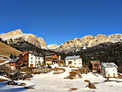
The ‘frazioni’ that compose the village are: Villagrande (the ‘centre’ of town, as we have seen), Canazei, Codalonga, Pezzei, Pian-Fossal, Posalz and Rucavà and many of them display interesting vernacular architectures (see image below). Smaller, more isolated hamlets are Rovei, Colcuc and Tie.
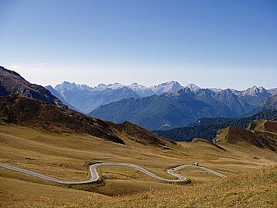
Once part of Tyrol (and therefore of Austria), only in 1923 was the territory of Colle aggregated to Veneto. In 2007, a Referendum was held in order to propose the re-unification of Colle Santa Lucia (together with Cortina d’Ampezzo and Livinallongo del Col di Lana – that is, the so-called Ladinia Veneta) to the autonomous province of Bolzano/Bozen (South Tyrol). The majority voted in favour of this move and the municipality is following the procedure to achieve it, but given the current restructuring of the provincial Italian system, the future is quite uncertain (below, an image of the road winding up on the meadows towards Passo Giau).
Return from Livinallongo to Agordo
Return from Livinallongo to Italy-Tours-in-Nature
Copyright © 2012 Italy-Tours-in-Nature

New! Comments
Have your say about what you just read! Leave me a comment in the box below.