- Italy Tours Home
- Italy Ethos
- Tours 2023
- Blog
- Contact Us
- Dolomites
- Top 10 Dolomites
- Veneto
- Dolomites Geology
- Dolomiti Bellunesi
- Cortina
- Cadore
- Belluno
- Cansiglio
- Carso
- Carnia
- Sauris
- Friuli
- Trentino
- Ethnographic Museums
- Monte Baldo
- South Tyrol
- Alta Pusteria
- Dobbiaco
- Emilia-Romagna
- Aosta Valley
- Cinque Terre
- Portofino
- Northern Apennines
- Southern Apennines
- Italian Botanical Gardens
- Padua Botanical Garden
- Orchids of Italy
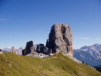
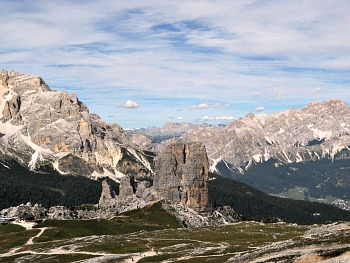
The ‘Cinque Torri’: Five Mythical Towers at the Heart of the Dolomites.
The Geography of the ‘Five Towers’
Sometimes also referred to as the ‘Cinque Torri di Averau’ (Fünf Türme in German; ‘Five Towers’ in English), this is a small mountain range belonging to the Nuvolau group (which culminates at 2,647 m on Monte Averau), within the Dolomiti Ampezzane in the Northern Dolomites, just to the SW of Cortina.
As most of the mountain formations in the area, the Cinque Torri are also formed of Dolomite, characterized by the peculiar light grey colour that distinguishes it (even though there is also some variation to the palette – see below) from the other rocks. This small range is formed by five spurs from which it derives its name; the maximum altitude is 2,361 metres on the Torre Grande.
Each ‘tower’ has its own name:
The Torre Grande – the major one – presents three peaks, very much sought-after by rock climbers: Cima Nord, Cima Sud and Cima Ovest;
The Torre Seconda is also composed of three distinct peaks, known as Torre Lusy, Torre del Barancio and Torre Romana;
The Terza Torre, a.k.a. Torre Latina;
The Quarta Torre is formed by two distinct rock tooth of different height and size, for this reason respectively called Torre Quarta Bassa and Torre Quarta Alta;
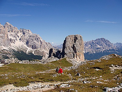
The Quinta Torre, or Torre Inglese (below is an overview of the ‘Five Towers’ emerging from the surrounding plateau).
The ‘towers’ are situated on the south-western edge of the Cortina basin (Conca ampezzana), just to the north of the nearby mountain group of Nuvolau/Averau (2,647 m), of which the Cinque Torri can be considered part. In the area of the Cinque Torri the following mountain huts (‘rifugi’) can be found: Rifugio Cinque Torri (2,137 metres); Rifugio Scoiattoli (2,255 m); Rifugio Averau (2,413 m) and Rifugio Nuvolau (2,574 m) – all described in more detail below.
The Nature of the Cinque Torri
Excursions
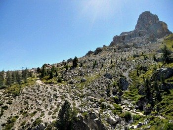
During the summer it is possible to embark on several treks and excursions in the surrounding woods and trails; the latter are usually well-equipped and properly maintained, and also carefully marked by the CAI (Italian Alpine Club). Amongst these, we need to remember at least the Alpine Highway No. 1 (‘Alta via n. 1’) and the trails around the so-called ‘Muraglia di Giau’ – a sort of lesser “Chinese wall”, marking the historical boundary between Cortina and San Vito in the Boite Valley.
The itineraries towards the Nuvolau (2,575 m) and Passo Giau (2,236 m: the area of the Cinque Torri can be accessed from this pass too) are well-worth an excursion, and so are the historical trails within the trenches of WW1 (the Cinque Torri are part of an open-air museum dedicated to First World War events, divided into several locations; see below).
Rock Climbing
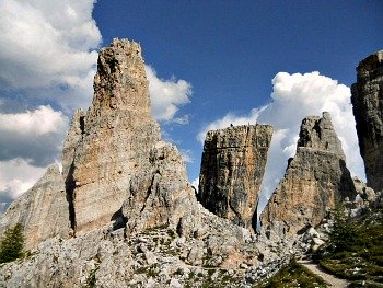
The Cinque Torri are a highly frequented area by mountaineers and by amateur and professional rock climbers alike, thanks to the high number and wide choice of ‘ways’, of varying degrees of difficulty. There have been some historical ascents on these vertical rock walls, which are also the traditional home of the “Scoiattoli di Cortina” – the renowned group of climbers known as “Cortina Red Squirrels” (see an image of the rock walls – with climbers tackling them – below).
Skiing
During the winter, the Cinque Torri become an important skiing hub, connected both with the Lagazuoi and the Col Gallina slopes; a new (debatable) skilift now allows also to reach the slopes past Monte Averau and around Passo Falzarego, making this – on the whole – one of the foremost skiing areas of the Dolomites.
History
This area was the theatre of harsh, bitter fights between the Italian and Austrian troops during WW1, as the frontline passed right through here, and still to this day the Cinque Torri retain lots of evidence of both the fights and – perhaps most importantly – the structures that were erected by the Italian army in support of the war activities, recently restored with a project of renovation and improvement which is aimed at enhancing the area historically: a point of view that had long been undervalued and almost forgotten (understandably so, perhaps) in the past.
The final outcome of this project has been the creation of several interesting historical trails including both the Cinque Torri and nearby Lagazuoi (2,835 m) ranges. Within the two areas – both centered around a distinct massif – has in fact been achieved the most extended open-air museum dedicated to WW1 in the Italian Alps (see image below), covering a radius of about 5 km, and complemented also by the newly refurbished Museum at Forte Tre Sassi, in the vicinity of Sass de Stria (2,477 m) – the Witches’ Rock: a peak that can be encountered along the stretch of road between Passo Falzarego (2,109 m) and Passo Valparola (2,192 m).
Mountain Huts around the Cinque Torri Area
The Cinque Torri area can be reached directly via a chair-lift from Bai de Dones, along the Cortina-Falzarego National Road, but also quite easily via paths and trails that start from along the same National Road (which is also, incidentally, the Great Dolomite Road, west of Cortina), some distance further up towards the Falzarego pass (or from the pass itself). The paths starting from here are all relatively gradual in their rise, so they would be suitable for most abilities; CAI-marked trail no. 441 is perhaps the most fascinating for an ascent, as it crosses a so-called Città di Sassi (Stone City; pictured below). Given the great number of marked trails that criss-cross the area extensively, there are several possibilities of combining the paths to devise a circular route.
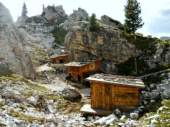
The Rifugio Cinque Torri (2,137 m) was founded originally as a hotel when the area was still Austrian, and it later became an operative centre during WW1. It can be reached either directly from Cortina (through the Bai de Dones area) or from the Falzarego and Giau passes. It is often used as a base by the rock climbers tackling the demanding routes on the Cinque Torri’s rock faces; a similar function is fulfilled by the smaller and simpler Rifugio Scoiattoli (2,255 m), which is situated nearby.
Both huts can be used as a base to hike in the area, or as a way to reach other mountain huts that are located at a slightly higher altitude, such as Rifugio Averau (2,413 m), which shares a similar story to Rifugio Cinque Torri (as a note of curiosity, it might be interesting to add that this mountain hut is still run by the descendants of Santo Siorpaes, who accompanied as guide the Austrian mountaineer Richard Issler – the first man to conquer the summit of Monte Averau, 2,647 m, in 1874).
Nearby Rifugio Nuvolau (2,574 m) deserves a special mention as the first mountain hut to have been erected in the Dolomites, at a time when the region was still Austrian (1883). Originally called Sachsendankhütte by its founder as a sign of gratitude – following an almost miraculous recovery from an illness in that area – the first building was destroyed in the course of WW1, and later re-erected (after Cortina became Italian) with its current name.
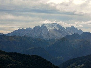
Both these huts can be used as bases for excursions in the Cinque Torri area, or as stopping points when crossing the rocky wastes between Passo Falzarego and Passo Giau (below, climbing up from the Cinque Torri area one reaches Rifugio Averau, 2,413 m, which offers a majestic view on the other side of the valley over the glaciers of the Marmolada).
A Closer Look at the Geology of the Cinque Torri
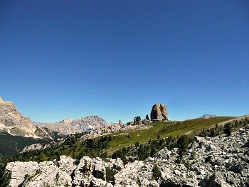
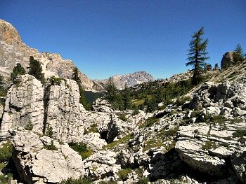
The Cinque Torri (‘Five Towers’) are located SW of Cortina, near Passo Falzarego. Situated to the south of the impressive Tofane group (Tofana di Rozes 3,225 m) and NE of the Nuvolau (2,575 m) and Averau (2,647 m) massifs, they lie on an open plateau at the boundary between Western and Eastern Dolomites. They are also positioned on the watershed between the Boite and Cordevole rivers, both tributaries of the Piave (below, particular of a rock formation in the Cinque Torri).
They Look Like ‘Fragments of Hanging Rocks’ – Why?
Well, in fact that’s what they are. In a nutshell, the Cinque Torri are made of Dolomia Principale (Main Dolomite) – a compact and well stratified rock formation; underneath, there are the layers of a much thinner formation: a mixture of clay, fine Dolomite and chalk. It is easy to imagine how unhappily Main Dolomite sits on such a soft ‘cushion’ – so to speak. And as if that were not enough, through various tectonic vicissitudes the Pre-Alpine deformations have produced numerous vertical fault-lines (surfaces of mechanical discontinuity that can still be appreciated today) along which a sliding movement has developed.
These faults have fractured the rocks and shattered the landscape. The faults have a created huge ‘steps’, lowering some areas at the expense of others. As a matter of fact, the Averau (which lies higher than the Cinque Torri; 2,647 m) is also made of Main Dolomite, but because of those ‘steps’ it has been lifted at a much higher altitude, while the five towers have been left where they still stand today: small and isolated, they look very fractured, and hanging over a frail and supple basement, which is slowly sealing their destiny (in the image below, observe how the Cinque Torri are rising out of soft, undulated soils).
Looking Around
These ‘steps’ can also be seen from the Cinque Torri themselves; especially when looking towards the south-west, they seem like a series of lowered flat surfaces. These surfaces are due to faults, and the rocks that constitute them are those of the so-called ‘Piattaforma Cassiana’ (Cassian Platform). The erosion has taken away with it two formations that were originally placed above the platform, and that we will encounter again later: the Heiligkreuz and Travenanzes Formations. Following the action of the fault-lines, between the Averau and Nuvolau a Graben was created (from a German word which means ‘moat, pit’).
All the Rocks Surrounding the Cinque Torri
There are four names to remember here – those of the four formations visible in the landscape around the Five Towers. These are: 1) the Dolomite of the Cassian Platform; 2) the Heiligkreuz and 3) Travenanzes Formations; 4) Main Dolomite. One number is also important: 228 – that is, 228 million years ago; alias ‘Upper Triassic’.
The names of the formations are characteristic, and were given by the geologists in order to identify, in various places, always the same rocks. So the names originate from the place where a given type of rock was either found first – or more clearly and abundantly. The different types of rocks can be more or less thick, but the main point is that they all have to be easily identifiable, and ought to be grouped according to the characteristics that distinguish them from other layers, above and below.
And So The Story Goes...
In a nutshell, this is what happened: at the beginning there was a situation analogous to that of the actual Maldives and Bahamas – a vast platform with just a thin layer of sea-water; a reef fringed this plain, and a modest slope led from it to the ocean: this is the typical situation of the Kassian Platform, and the sediments that were deposited in the basin opposite were consequently called ‘Formazione Cassiana’ (Cassian Formation).
As anticipated above, this happened during the Upper Triassic, around 228 million years ago. Then another platform formed itself, very similar to the previous one; at last, the marine sediments filled the gaps left empty between the two platforms, and submerged them abundantly. Around halfway through the Carnian age, in a narrow time interval called Julic-Tuvalic, above the latter platform a proper beach was formed, where calcium carbonate – as in the platforms – was equally being deposited, but with a slower cementation process; it was an environment of ‘carbonate ramp’ (a band that connected the platform to the sea), and this is known today as the Heiligkreuz Formation (formerly Dürrenstein).
During the course of the Upper Carnian, the climate turned arid, and evaporation became a common phenomenon where water was low. In this area – identified as ‘sabkha’ (a sort of tidal salt-flat) – then started the deposition of the Travenanzes Formation (formerly Raibl).
At a certain point, the clayey sediment gave way to a completely carbonatic sediment, organized in a series of peritidal cycles (basically, the sea was coming and going), with bio-turbated lagoon-type sediments (where small organisms dug holes and galleries) and the presence of a bivalves’ fauna such as the Megalodonts (large snails with two valves like mussels, but with a thicker shell; now extinct, they are frequently found in the Main Dolomite). Many kilometers to the north-east carbonate reefs were formed, and these were a lot steeper than the gentle slopes of the Travenanzes Formation: thus began the formation of the more famous Main Dolomite.
What is the Cassian Platform?
It is a sedimentary body of rock formed by carbonate produced on the spot by marine organisms. These have attached themselves onto precedent sediments which had filled the basins that were created during the basic volcanic events of the Middle Triassic. These were reefs that had been made ‘Dolomitic’: Dolomite is a carbonate that contains magnesium that has substituted the original rock – which was limestone; this means that often it is not possible to recognize the original texture and its sedimentary structure. Compensating for that, though, is the fact that one can still distinguish the depositional geometries, as for example the underwater scarp (‘slope facies’); in actual facts, here two platforms can be recognized, the Nuvolau Platform and the Lagazuoi Platform. Between them there was a basin in which deep marine sediments were deposited (the so-called ‘Formazione Cassiana’ – Cassian Formation). Sealing this situation we find the layers of the sedimentary sequence – predominantly of a shallow sea – of the Heiligkreuz Formation.
The Heiligkreuz Formation
The Heiligkreuz Formation is being deposited in concordance (that is, a parallel deposition of other sediments) to the preceding basin formation of the ‘Formazione Cassiana’ (Kassian formation). It was being superimposed onto the platform scarp, and also onto the superior layer of that very same platform. From time to time, one can register some interruptions in the continuity of layers, probably due to sub-aerial exposure; one can in fact recognise some structures which are typical of paleo-karst situations. This type of succession signals a complex series of depositional events, where the climate certainly played a significant role, at that time when humid and semi-arid phases probably alternated.
The Travenanzes Formation
These are calcareous layers in which there was an alternation of terrigenous and carbonate levels, in a typical area of passage between continental and marine habitats. With this formation we are located on a coastal plain, in which one finds vast stretches of shallow sea subjected to evaporation, where a type of salt-flat would be formed (there areas are known today as ‘sabkha’). The climate, therefore, was arid; the carbonatic layers represent phases of marine ingression, where one already starts to notice those peritidal cycles which will be more widespread and typical of the successive Main Dolomite (in order of deposition), with fossils of bivalves (such as Megalodonts) and Stromatolites. One also finds peritidal cycles with intercalations of clay. The limit with the superimposed Main Dolomite is signaled, in fact, by an interruption in the terrigenous supplies: this differs from the clear-cut, neat inferior limit that separates the Travenanzes from the Heiligkreuz Formations; the upper limit with Main Dolomite happens gradually, with a transition – thus witnessing the fact that the two sedimentary environments were actually quite close to one another.
The Rock and its Peculiarities
The huge Dolomite slab is extended as a powerful succession of homogenous rock typical of peritidal environments (areas that were subject to tidal fluctuations), present in a large section of the southern Alpine range. Some of the most important peaks of the Dolomites are made of Main Dolomite: Tofane (3,225 m), Cristallo (3,221 m), Marmarole (2,926 m), Antelao (3,263 m), Pelmo (3,168 m), Averau (2,647 m), just to mention a few – and of course the Cinque Torri themselves.
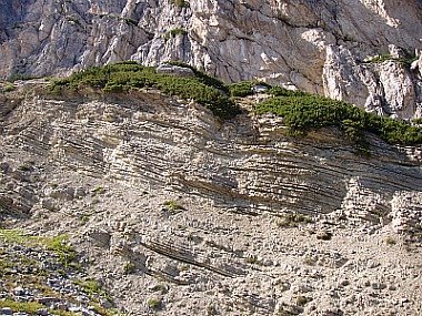
This formation is constituted of lightly-coloured Dolomite, whitish or grey, well-stratified. One finds here alternated – in a cyclical fashion – thinner layers of stromatolites (algae mats turned into soft rocks) with other thicker layers, containing bivalves’ fossils such as gasteropods, bio-turbations and typical lagoon-type sub-tidal deposits (see below the particular of a rock formation in the Cinque Torri area).
The stromatolitic levels present sometimes some typical tepee-structures and mud-cracks. The former are structures in which the layers present some folds that resemble in shape a Native American tent; these are due to the surface expansion following cementation; the latter are regular polygons that are being formed by dessiccation in conditions of high aridity. Both phenomena represent a typical sub-aerial exposure of sediments, and witness a typical tidal plain – or tidal flat – environment; therefore, a situation that would periodically be emerging from the water, in which it is possible to find dinosaurs’ and other tetrapods footprints – as for instance on the Pelmetto (2,990 m; for more information on this, refer to the Civic Museum “Vittorino Cazzetta” page, situated in nearby Selva di Cadore) or even on the more famous Tre Cime (2,999 m).
The Layers (‘stratifications’): How Do They Look Like?
Main Dolomite, more than any other type of rock visible here, clearly shows what a stratification really is – that is, the major or minor thickness of a rock layer. Between one layer and another one can also identify areas that are usually defined as ‘stratification surfaces’ (i.e., surfaces without thickness), in which – for a fraction of geological time – there was no deposition, or rather the conditions had suddenly changed; at the same time, there can also have been erosion. A layer can be recognized as it has characteristics that make it differ from the other rocks above and below. Through the correlation of the different layers it is possible to establish a correspondence between different mountain groups, or even – as in the case of the Cinque Torri – to observe how much the individual towers have moved amongst (and in comparison) to each other.
Main Dolomite – the Rock of the Dolomites
The majority of Dolomite rocks originate from pre-existing calcium carbonate; the calcium ions of carbonate are then substituted by magnesium ions. For this process to happen, though, it is necessary that the carbonate goes into a solution, and that a substitution of the ions takes place – this will in turn allow the precipitation of Dolomite. All this process is to be located within a water solution that percolates through the loose sediment or the rock itself.
The fundamental pre-requisites for such a process to take place are: a high concentration of magnesium ions, so that a chemical reaction can happen – and also a mechanism that allows sufficient quantities of Dolomite solutions, with enough time for the process to be completed. ‘Dolomitization’ happens for instance in environmental conditions of hyper-salinity such as in lakes or tidal areas where there is a intermingling of fresh- and salt-water; algae and bacteria also seem to favor the ‘Dolomitization’ process. Some of the great Triassic Dolomite formations have in fact originated from such a process, which has also produced the immediate consolidation of the rock sediments as a result: this is what is called a precocious type of diagenesis.
‘Microworlds’: Those Little Known Fossils…
At the basis of the construction of the whole Dolomite landscape (a process that, as we said earlier, started about 228 million years ago, in the Upper Triassic – the age of the Cassian Platform) there were small and original marine organisms – quite unlike the more famous dinosaurs. The remains of the fossil faunas – albeit often microscopic in nature – have at times revealed important presences, in that respect. It is a fact that the reefs were formed by corals, such as those of the Cassian Platform, and that bivalves (two-valved shells similar to current days scallops) and gasteropods (shells with a spiraling husk) were present too, but it is known that other marine organisms also existed, and that they were very different amongst themselves – such as the echinoderms.
These were basically sea urchins, starfishes, sea gherkins, sea lilies, and starfishes with longer and thinner arms. What they all had in common was a symmetrical structure, a calcium-based inner skeleton and a very peculiar poly-functional apparatus (respiratory, locomotion and nutritional altogether). These marine forms still all exist today, and they tend to prefer well-oxigenated waters with normal levels of salinity, although they can live at all depths – even in the abysses – and are just one of the components of the so-called Cassian fauna. In the sea basin facing the Cassian Platform are in fact deposited the sediments that form the Cassian Formation, which contain calcareous sponges, brachiopods, foraminiferous creatures, algae and hydrozoans.
Tectonics
When describing the rock successions seen up to this point there are no complications: they appear regular, and overlaid on top of each other almost like the layers of a cake or the pages of a book. On one side, there are the platforms that pro-grade (advance) over a basin extended to the east – in a sea that at times expandend and at other times retreated; in fact, the only disruption came several million years later, with the emergence and rising of the Alpine chain: at that point, the tectonics would produce an important discontinuity line or fault (to be precise, there were two of them, semi-parallel; the Falzarego fault and the Valparola fault).
The latter is an over-thrust oriented to the south that has taken the ‘Lagazuoi-Tofane’ block above the underlying ‘Sasso di Stria-Averau-Nuvolau-Cinque Torri’ block. The units of the Travenanzes and Heiligkreuz formations are thus found both at the Falzarego pass and above, on the Lagazuoi plateau. The displacement has been of more than 1,000 metres vertically, but of as much as 10 km horizontally (as a result of the sliding movement); the whole complex of the stratification clearly presents itself as sinking towards the north (which implies an inclination of the layers in respect to a horizontal axial plain).
Geo-Morphology
The superficial effects of the tectonic movements – somehow deeper – are to be found also in geo-morphology: valleys and rock faces are structured on important dislocation lines such as faults. Lithology, instead, shows the immediate effects of erosion: competent (which basically means resistant to erosion) rocks such as Dolomite form aiguilles, needles, rock faces (known here as ‘crode’), peaks and rock bastions, whereas clays, marl and pelites are being modeled into soft shapes, often becoming covered in meadows.
The glaciations – which in the Pleistocene and in the Olocene have occupied with their glaciers the Alpine valleys at least four times – have left noticeable erosion forms such as glacial cirques and also moraines as a result of accumulation. Such an articulated landscape also imposes itself where the Karstic phenomena have been active; detritus’ cones and slopes are instead the evident product of gravity and of freezing-thawing cycles. In particular, in the area these latter range from scree (known locally as ‘ghiaioni’) to potent debris-flow cones.
The Cinque Torri in Detail
Once the Cinque Torri were part of the same Dolomite block as the Averau (2,647 m). They were lowered because of faults, but at the same time they were spared in part by the erosion that on the contrary – in the more elevated areas – had taken everything away all the way to the Heiligkreuz and Travenanzes Formations layers below, bringing to light the underlying, inner Cassian Platform.
The Cinque Torri are thus a precarious system that weakens day after day, mainly because of two factors: the first is the presence of two big fractures; with an aerial view this becomes very apparent, and the fractures show two prevailing directions. On the other hand, the action of freezing-thawing cycles, whereby ice – augmenting in volume – produces a mechanic pressure on the rocks, acts winter upon winter upon the pre-existing fractures. The second factor is that the Five Towers sit on a not very solid (inconsistent) substrate of clays of the Travenanzes Formation, and therefore there is the occurrence of regular – and inevitable – collapses, due to particular mechanic situations: this is clearly favoured by the regular stratification of the Main Dolomite, whereby often the layers' joints also become weakness points.
The Collapses: Is It All The “Spreading’s Fault”?…
The collapses are interesting gravitational phenomena that imply the fall of rocky parts, often from a steep rock face, for different reasons. The primary cause to be considered responsible for a series of different collapses in the area of the Cinque Torri is the so-called spreading: a fundamental pre-requisite for this phenomenon to occur is the presence of horizontal layers, deeply cut by an important network of joints – such as the fractures and the folds described before – above a more malleable layer of plastic material.
The weight of the rocky banks known as ‘competent’ (see above) of Main Dolomite above the marl-clayey layers of the Travenanzes Formation produces deep plastic deformations in the clays, which then become wrung out and swollen wherever they find enough free space, thus also inducing a loosening of the rock surface. These deep deformations kick-start – in turn – a process of lateral expansion for which the blocks become enlarged towards the outside, spurred on also by the swelling of the underlying plastic material. In such cases, one then speaks of ‘lateral spreading’ – that is, of a deformation/expansion with a sideways trend, which takes off-centre the blocks’ barycentre (see below an image of typical rock collpases in the Cinque Torri area).
Description of the ‘Five Towers’
The Torre Grande (‘Great Tower’)
The Torre Grande presents itself as decomposed by fractures that split it into three distinct monoliths: Cima Nord, Cima Sud (the highest; 2,361 m) and Cima Ovest. One can see, from above, how the movement of the blocks confirms the ‘lateral spreading’ mentioned above: a containing lateral pressure is almost completely absent, and in this way the fractures seem to open up even wider – as in a rose. To continue with the metaphor of the towers as roses, this means that – in geological times – their destiny is sealed, and it will be that of ‘losing their petals’.
The Torre Trephor (‘Trephor Tower’)
In 2004 the Torre Trephor fell down all of a sudden, without much notice and compliments – just like that. What happened then was a phenomenon of over-turning: the height of the rock wall in comparison to its base was a decisive factor; generally one distinguishes an over-turning from a sliding trend by the relationship width-height of the block; high and narrow blocks tend to overturn, and in this case the height was a determining factor. To exacerbate the situation, there were also other factors that need to be taken into account, such as variations in the water content of the soil and the freezing-thawing cycles – which weakened and altered the fractures in the rocks by deepening them. Other contributing factors were the erosion of the surrounding slopes and – finally – the pressure of water from within the joints and stratification layers; therefore, the tower saw its barycentre move and ‘lost the balance’ – so to speak.
The Torre Inglese (‘English Tower’)
The University of Padua is monitoring the complex of the Cinque Torri, and a GPS antennae has been placed on top of the Torre Inglese (‘English Tower’) in order to constantly survey its geographical position, and thus detect any possible movement in real time. These are sophisticated instruments which are used in order to measure and control the relative movements of the cracks and their edges, or for structural checks on the rock faces; in this case, they have been positioned at the base of the tower.
Boulders
A massive landslide has come down from the Torre Grande (‘Great Tower’): it has collapsed, leaving behind a detachment niche shaped like a dihedral, which runs vertically all along the rock wall. The rock, in these points, has a different colour from the external parts, which have become more altered by the atmospheric agents, as they were exposed for a longer time. In the Main Dolomite, this exposed area – as it is ‘fresher’ – results more of a rose-yellow colour.
The presence of a line of discontinuity, the layering of the rock strata inclined towards the valley floor – and gravity – may all have altered the original equilibrium of the rocky mass: this happens especially where the cracks are being opened up and dilated by the cycles of freezing-thawing; eventually, one has a chemical deterioration of the rock as a result, and there will usually be a massive hydration of the clayey material at the layers’ joints too, with a consequent rise of the hydrostatic pressure. This also happens when the inclination of a slope increases or – because of erosion – the matrix that used to include and compact these rock parts is lost. In the collapse phenomena that involve the Cinque Torri one has to take into account the blocks or fragments of coherent rock of varied dimensions that detach themselves from a mass of bigger proportions – but also the collapse of entire towers, such as it happened when the Trephor Tower fell down (read above).
Protecting the Cinque Torri: Are They Falling or Not?!?
Well, ... no – not for the time being, at least. At the time of the collapse of the Trephor Tower there was a lot of talking about global warming and its role and responsibility in accelerating the normal erosion processes that have always taken place on the planet’s surface.
The water that penetrates into the rock fractures augments in volume with the cold and through freezing; the continual cycles of freezing-thawing in turn widen the cracks in the rocks, and that – over time – originates the well-known detachment of rock surfaces which can cause a collapse. All this can also happen between one layer and another, when the water infiltrates itself, polishing and eroding the rock, and similar effects can be determined by the sun, wind, etc.
In the case of the Cinque Torri, the prime motive of their weakness lies above all in the fact that they rest on such an unstable and inconsistent type of soil. Clays belonging to the Travenanzes Formation can easily be de-formed under the weight of Dolomite, and this is roughly how it works: the underlying clays are being bent and contorted to such as extent as to separate themselves from the weight of the Dolomite above, and to produce – whenever they find an appropriate space where to expand – a sort of swollen lump (to help you visualize the phenomenon, you can think of the same effect we get when we lay our head on a pillow made of feathers).
Whenever they swell, these surfaces lose compactness, and they display no more the counter-pressure that contained them; in this way, they withdraw the solid base that was given to the Dolomite: inevitably, this means that the towers will tend to translate and collapse – bearing in mind that this is a process that takes place extremely slowly.
Even if the ultimate occurrence of a rock collapse is something that happens quite suddenly and abruptly, on the whole this process has the breath of the Earth – which by the speed of our watches we calculate in the order of millions of years. This, of course, means that given our time standards we will not see these beautiful mountains disappear overnight – but that is what they are ultimately geared towards: eventually, even the Dolomites will be gnawed by erosion and reduced to flat lands. This should also, however, give us an awareness of the fact that safeguarding our geological and naturalistic heritage is an absolute priority – a first sign in the direction of protecting our Planet and a decisive move towards its global health (below, an atmospheric view of the Cinque Torri – contemplating their future, perhaps?).
Return from Cinque Torri to Dolomites
Return from Cinque Torri to Italy-Tours-in-Nature

New! Comments
Have your say about what you just read! Leave me a comment in the box below.