- Italy Tours Home
- Italy Ethos
- Tours 2023
- Blog
- Contact Us
- Dolomites
- Top 10 Dolomites
- Veneto
- Dolomites Geology
- Dolomiti Bellunesi
- Cortina
- Cadore
- Belluno
- Cansiglio
- Carso
- Carnia
- Sauris
- Friuli
- Trentino
- Ethnographic Museums
- Monte Baldo
- South Tyrol
- Alta Pusteria
- Dobbiaco
- Emilia-Romagna
- Aosta Valley
- Cinque Terre
- Portofino
- Northern Apennines
- Southern Apennines
- Italian Botanical Gardens
- Padua Botanical Garden
- Orchids of Italy
The
Northern Dolomites Include Renowned Peaks as the Antelao, Tofane and Cristallo.
The Northern Dolomites are the name given to the largest of the nine areas that collectively make up the Dolomites UNESCO World Heritage Site, which includes some of the most renowned mountain ranges not only of the Dolomites but of the entire Alpine range, such as the Dolomiti di Sesto/Sextnerdolomiten and the magical plateaus of Fanes and Sennes.
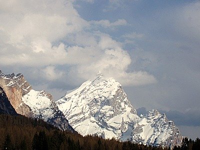
Among the most celebrated peaks, in decreasing order of altitude, this system includes the Antelao (at 3,264 m the second highest summit of the Dolomites; pictured above from Cortina), the three Tofane (Tofana di Mezzo, 3,244 m; Tofana de Inze, 3,238 m and Tofana di Rozes, 3,225 m); Cristallo (3,221 m); Sorapis (3,205 m); Punta Tre Scarperi (3,152 m); Croda Rossa/Hohe Gaisl (3,146 m); Croda dei Toni (3,094 m); Cima Undici (3,092 m); the renowned Tre Cime di Lavaredo/Drei Zinnen (2,999 m); the Marmarole (2,932 m) and finally the Cadini di Misurina (2,839 m; in the image below, the back of the Cristallo, pictured from the road that connects Cortina to Misurina through the Tre Croci pass).
The Northern Dolomites are bounded by mountainous systems all around; they are limited to the north and west by South Tyrol, with the valleys (anti-clockwise) of Sesto/Sexten, Pusteria/Pustertal, Badia/Gadertal and San Cassiano/St. Kassian, while to the south and east they are flanked by the Ampezzano and Cadore regions, with the Boite and Piave valleys.
On the eastern side, the Ansiei valley cuts more directly into the region, branching off northwards at Auronzo, and separating like a wedge the Marmarole group from the Cadini di Misurina.
The Northern Dolomites are a varied system, protected by three different Regional Natural Parks, such as the Dolomiti di Ampezzo, Fanes-Sennes-Braies and Dolomiti di Sesto/Sextnerdolomiten.
The Northern Dolomites are also very articulated, broken up into many peaks alternated with plateaus and lakes – the latter framed like jewels by the surrounding crags and woods.
This extraordinarily evocative succession of fantastic landscapes has given rise to many ancient legends and sagas – and it couldn't have been otherwise, as the Dolomites’ beauty and the sense of awe they inspire cannot leave one untouched (even though that was not always the case).
But the real highlight is from a geological point of view, as this mountain system offers the most complete stratigraphic sequence found in the whole Dolomites.
It starts with the metamorphic bedrock (which is a remnant of the ancient mountain chain that was flattened at the beginning of the Permian period), and it leads all the way up to the most recent (so to speak – 30 million years ago!) Oligo-Miocene outcrop, evidence of which appears at Monte Parei (2,793 m).
The succession of different environments that have characterized the geological history of the Dolomites is extraordinary, and it is displayed here with astonishing completeness.
It ranges from the deserts of the Permian era to the tropical cliffs and sea-beds of the Triassic, then on to the lagoons and beaches of the Jurassic, and on again to the unfathomable depths of the Cretaceous.
Documentation of the geological past of the region is also illustrated at some of the most important fossiliferous sites in the world.
What they contain goes from the fossil plant deposits from the Anisian beds of Braies/Prags (belonging to the San Cassiano Formation), and includes corals from the Alpe di Specie; the oldest amber in the Mesozoic; the megalodontes in the Dolomia Principale; the ammonites of the Puez marls and the bears' footprints, which can be admired by the mythical Conturines group – and these are just but a few examples of the paleontological wealth that these mountains can offer, which has very few matches on the entire planet.
Expressions of the geological phenomena that have led the rocky sea-beds of the Dolomites to become mountains can also be appreciated in the folds, fault-lines and corrugations that characterise the area.
A wide range of geo-morphological processes too can be found within the vast system of the Northern Dolomites, from those phenomena connected with deformations of the terrestrial crust – as demonstrated by the high-energy of the relief and a series of fault scarps – to the morphoclimatic shapes linked to climatic vicissitudes, and bearing numerous signs of ancient modeling by ice.
Karstic phenomena are also well represented on the high plateaus above Ampezzo, as well as the morpho-dynamic activity – some still ongoing today – which is expressed most notably by several examples of landslide phenomena.
Highlight Trails and Mountain Huts
The Fanes Plateau-Sennes Area
Within this system, the Fanes plateau qualifies as one of Italy’s finest tracts of limestone scenery. Guarded by a ring of peaks, it is nestled at the heart of the region, and is one of the Northern Dolomites’ wildest areas, all contained within the Fanes-Sennes-Braies Natural Park.
This high plateau – averaging 2,000 m of altitude – is said to be the seat of the mythical legend of the Kingdom of the Fanes, and is like a veritable city of stone, surrounded by the most dramatic rock shapes. Luckily for the wanderer, this eerie wasteland is also peppered with several mountain huts where to find shelter after a long haul, or in the case of not so unfrequent extreme weather events such as high winds or heavy storms.
These huts comprise – in sequence when reached from Cortina: Malga Ra Stua (1,668 m, which is really the gateway to the area), from where Rifugio Sennes/Senneshütte (2,126 m) can easily be reached. From there, one can branch off in several directions; towards Marebbe/Enneberg one can climb to Rifugio Fodara Vedla (1,980 m), connecting also with Rifugio Pederù (see below).
Slightly above is Rifugio Munt de Sennes (2,176 m), while when heading eastwards – towards Braies/Prags – one is bound to encounter Rifugio Biella/Seekofelhütte (2,327 m), under the weird rock formations of Croda del Becco/Seekofel (2,810 m), the Beak’s peak.
Certain pockets of astonishing scenery – such as the Lago di Braies/Pragssee, caught in a cwm at the northern edge of the system – have their share of summer coach parties, but all in all, the area is still largely ignored by tourist herds.
These mountains offer stunning panoramas, especially around the Croda Rossa/Hohe Geisl (3,146 m), the Conturines group (3,064 m) and the Picco di Vallandro/Dürrenstein (2,839 m).
Paths can be some of the Dolomites’ loveliest – and loneliest. The Alta Via No. 1 (‘Alpine Highway’) starts in Braies/Prags and crosses the whole region until Pieve di Cadore, while for the less experienced hikers there are the old military tracks at Prato Piazza/Platzwiese.
These beautiful open meadows can be accessed either by road from the Braies/Prags area – but this option is not advised to the dedicated walker, who can make the most of the beautiful and easy trails climbing to the area, especially from the valley floor at Cimabanche/Im Gemärk or Carbonin/Schluderbach (along the National road connecting Cortina to Dobbiaco/Toblach).
Apart from Braies/Prags, other lakes worth visiting are clustered around two mountain huts further west, Rifugio Fanes/Faneshütte (2,062 m) and Rifugio La Varella (2,042 m) – such as, for example, the tiny Lago di Fanes and Lago di Limo, dwarfed by the huge crags of Cima Scotoni (2,874 m).
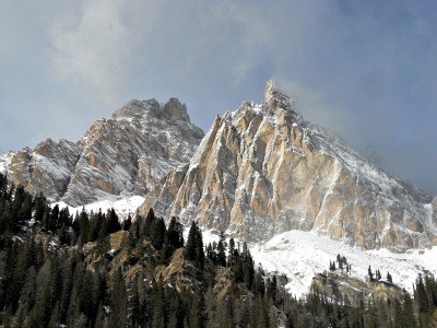
Unlike many others in the Dolomites, here the peak summits tend to be more accessible to the average walker: there are long, silent paths along the Val di Foresta and in the wild, solitary wastes around the red-coloured Croda Rossa/Hohe Geisl (3,146 m; see an image below).
The Area of Prato Piazza
More trails ascend from Passo Cimabanche/Im Gemärk, along the National Road to Dobbiaco/Toblach, and lead – amongst other places – to Rifugio Vallandro/Dürrensteinhütte (2,040 m): a mountain hut on the edge of the beautiful high pastures of Prato Piazza/Platzwiese, from which it is also possible to descend by the shores of the picturesque Lago di Braies/Pragssee.
Otherwise – but you would need a bit more training for this – there is the possibility to ascend from Prato Piazza/Platzwiese to the peak of Picco di Vallandro/Dürrenstein (2,839 m), which would reward you with a wide open view. An easier option from there is to climb up Monte Specie/Strudelkopf (2,307 m).
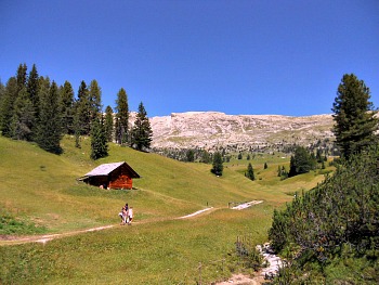
But even if you don't want to venture any further, Prato Piazza/Platzwiese is in itself a beautiful location: a wide, undulated upland pasture with stunning views over the Dolomites to the south and the Tauern chain (at the border with Austria) to the north (see image below).
There are at least three mountain huts on the plateau, on which you can rely for accommodation and/or a hearty meal: Rifugio Prato Piazza/Platzwiesehütte (1,991 m) and Rifugio Vallandro/Dürrensteinhütte (2,040 m), already mentioned above and open all year round, while a third facility – set in a beautiful wooden building – is open summer only.
On the other side from Cortina, more notable trails are to be found in the rugged Vallone di Lagazuoi and in the long, deserted Val Travenanzes; there is also a famous traverse from Rifugio Pederù (1,548 m) to the hamlet of Armentarola, through Passo Tadega (2,157 m).
The Sentiero Geologico Astaldi
Slightly more to the west of Cortina there is a chance to visit a couple of locations which are quite interesting in order to acknowledge oneself with the geology of this part of the Dolomites: the astounding Sentiero Geologico Astaldi is situated at the foot of the Tofane, and it can be accessed from Rifugio Angelo Dibona (2,083 m), just off the National road (Great Dolomite Road) to Passo Falzarego.
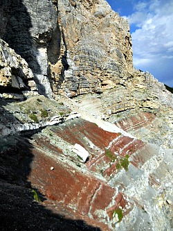
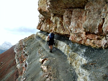
The Sentiero Geologico Astaldi (Astaldi Geological Trail) is a very compelling itinerary, almost suspended on a narrow ledge among multicoloured rocks. See above and below two images of the Sentiero Geologico Astaldi; the iron rope clinging on to the rock wall can be just about made out in the second picture. The crimson-red coloration is due to the presence of the Raibl layers (Strati di Raibl); for more detailed information on this trail, refer to the Tofane page.
A word of warning: although, in my opinion, this trail is an absolute highlight within the context of the Dolomites – and a rope fixed to the rock wall makes the experience quite safe – let me make this clear once and for all: despite not being, strictly speaking, a via ferrata – and therefore technical equipment not being compulsory – still great care should be taken when walking along the Astaldi Geological Trail, in both directions; also, it is not advised to people with little hiking experience or who are afraid of heights.
Another worthwhile visit, for its geologic features, is that to the area of the Cinque Torri (2,361 m), on which an easy-to-read publication has been written; it can be found on sale for a small price at the Cooperativa di Cortina. Bearing in mind that it is only in Italian, if you can read this language it gives an in-depth – but easy to understand – overview on the main geologic features of this area.
And now, let us finish off with a quote from Amelia Edwards, a pioneer English woman travelling across the Dolomites at the end of the 19th century. This is what she wrote in 1872, in Untrodden Peaks and Unfrequented valleys (as they still were then!):
«... and the extraordinary towers of the Drei Zinnen (Tre Cime) come one after the other into view. As for the Drei Zinnen, they surpass in boldness and weirdness all the Dolomites of Ampezzo. Seen through an opening between two wooded hills, they rise abruptly from behind the intervening plateau of Monte Piana, as if thrust up from the centre of the earth, like a pair of tusks. No mere description can convey to even the most apprehensive reader any correct impression of their outline, their look of intense energy, of upwardness; of bristling, irresistible force».
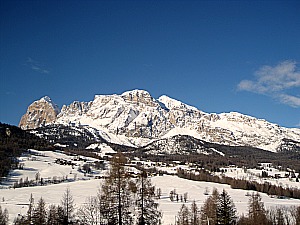
In the closing image below, a winter view on the Tofane as seen from Cortina.
Return from to Northern Dolomites to Dolomites
Return from to Northern Dolomites to Italy-Tours-in-Nature
Copyright © 2012 Italy-Tours-in-Nature

New! Comments
Have your say about what you just read! Leave me a comment in the box below.